Now that we know the Lord's language target for the Book of Mormon (see the blog article "
Early Modern English") was the Tudor period into the Stuart period (1500's and 1600's), we are prepared to investigate one of the most contentious phrases in the text, the "small neck of land"
Alma 22:32 aka "narrow neck"
Alma 63:5 aka "narrow neck of land"
Ether 10:20. What would English speakers in the Elizabethan, Jacobean and Caroline eras have considered a "neck" of land? How large would a neck of land have been? Would a neck have been surrounded by fresh water, estuarial water, salt water, some combination of waters or no water at all?
Fortunately, we have a great deal of data to work with that will help us answer these questions. During the Tudor and Stuart periods, waves of English colonists founded settlements from Nova Scotia to Georgia and beyond. They originated thousands of place names including hundreds of "necks" of land whose names still appear on modern maps. We will use Google Earth to analyze a statistically significant (though far from exhaustive) sample of 115 necks of land named by English settlers. Our conclusions will help us determine what kind of geographic feature we should be looking for when we try to locate Mormon's and Moroni's "narrow neck" on the modern map.
This article expands and extends the previous series of blog articles "
Isthmuses,""
Narrow and Small Things,""
Another Geographic Neck,""
The Narrow (Small) Neck of Land," and "
The Narrow Pass and Narrow Passage."
David R. Ransome published an article entitled "Village Tensions in Early Virginia: Sex, Land, and Status at the Neck of Land in the 1620s" in
The Historical Journal Vol. 43, No. 2 (June, 2000), Cambridge University Press. That particular neck of land is a meander in the James River downstream from modern Richmond in contemporary Chesterfield County. The famous Fry-Jefferson map of Virginia (Peter Jefferson was Thomas' father) first published in 1751 calls it simply "Neck of Land."
![]() |
| Neck of Land south of the James River settled by the 1620's |
The same 1751 map shows at least 2 other necks of land in Virginia. One is Henrico Neck in modern Henrico County.
![]() |
| Henrico Neck north of the James River |
The other is Savith (modern Savage) Neck in modern Northampton County on Virginia's Eastern Shore.
![]() |
| Savith Neck jutting into Chesapeake Bay |
These are the 115 necks of land in our study:
|
| Name | Location | Type | Width (km) |
| Arbuckle Neck | Accomack County, VA | 1 fresh 2 estuary | 1.80 |
| Bailey Neck | Accomack County, VA | 1 fresh 2 fresh 3 estuary | 0.70 |
| Baylys Neck | Accomack County, VA | 1 fresh 2 fresh 3 estuary | 1.34 |
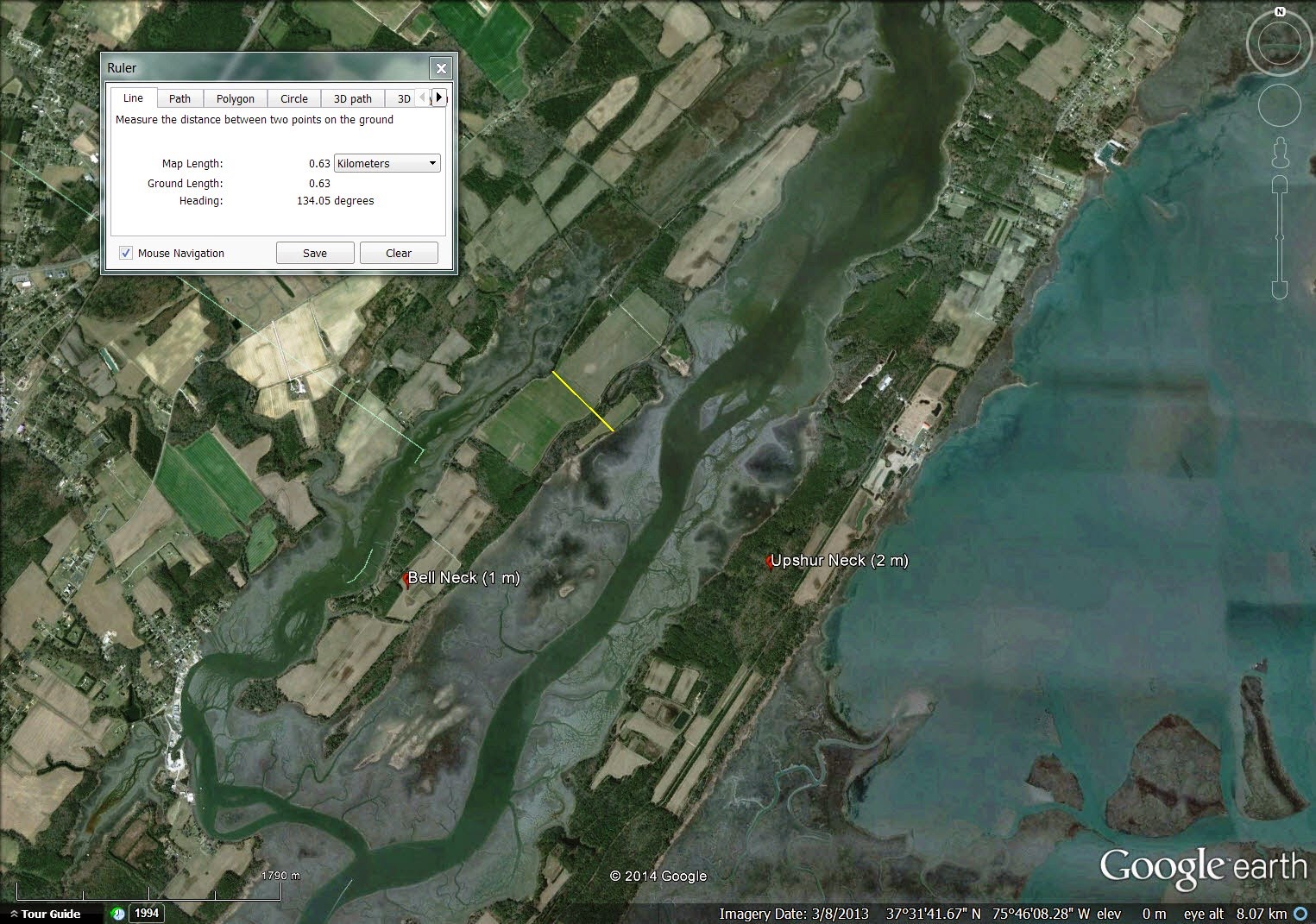
| Bell Neck | Accomack County, VA | 1 estuary 2 estuary 3 estuary | 0.63 |
| Big Neck | Brunswick County, NC | 1 fresh 2 fresh | 15.74 |
| Boone Neck | Brunswick County, NC | 1 fresh 2 estuary 3 estuary | 1.60 |
| Boston Neck | Suffolk County, MA | 1 fresh 2 estuary | 1.97 |
| Boston Neck | Washington County, RI | 1 fresh 2 salt | 1.40 |
| Bradford Neck | Accomack County, VA | 1 fresh 2 estuary | 0.98 |
| Brickhouse Neck | Northampton County, VA | 1 estuary 2 estuary | 0.26 |
| Broad Neck (earliest) | Anne Arundel County, MD | 1 fresh 2 fresh 3 salt | 1.10 |
| Broad Neck Peninsula | Anne Arundel County, MD | 1 fresh 2 fresh 3 salt | 5.93 |
| Broad Neck | Lancaster & Northumberland Counties, VA | 1 fresh 2 fresh 3 salt | 15.94 |
| Broadway Neck | Accomack County, VA | 1 fresh 2 fresh 3 salt | 1.64 |
| Broro Neck | McIntosh County, GA | 1 estuary 2 estuary 3 estuary | 0.53 |
| Bush Neck | Jame City County, VA | 1 fresh 2 fresh 3 fresh | 0.37 |
| Cherry Point Neck | Northumberland County, VA | 1 fresh 2 fresh 3 salt | 1.67 |
| Church Neck | Northampton County, VA | 1 fresh 2 fresh | 0.80 |
| Coles Neck | Westmoreland County, VA | 1 estuary 2 salt 3 salt | 1.98 |
| Copiague Neck | Suffolk County, NY | 1 fresh 2 fresh 3 salt | 0.99 |
| Cove Neck | Nassau County, NY | 1 salt 2 salt 3 salt | 1.27 |
| Crabtree Neck | Hancock County, ME | 1 salt 2 salt 3 salt | 2.24 |
| Craddock Neck | Accomack County, VA | 1 fresh 2 fresh 3 salt | 2.40 |
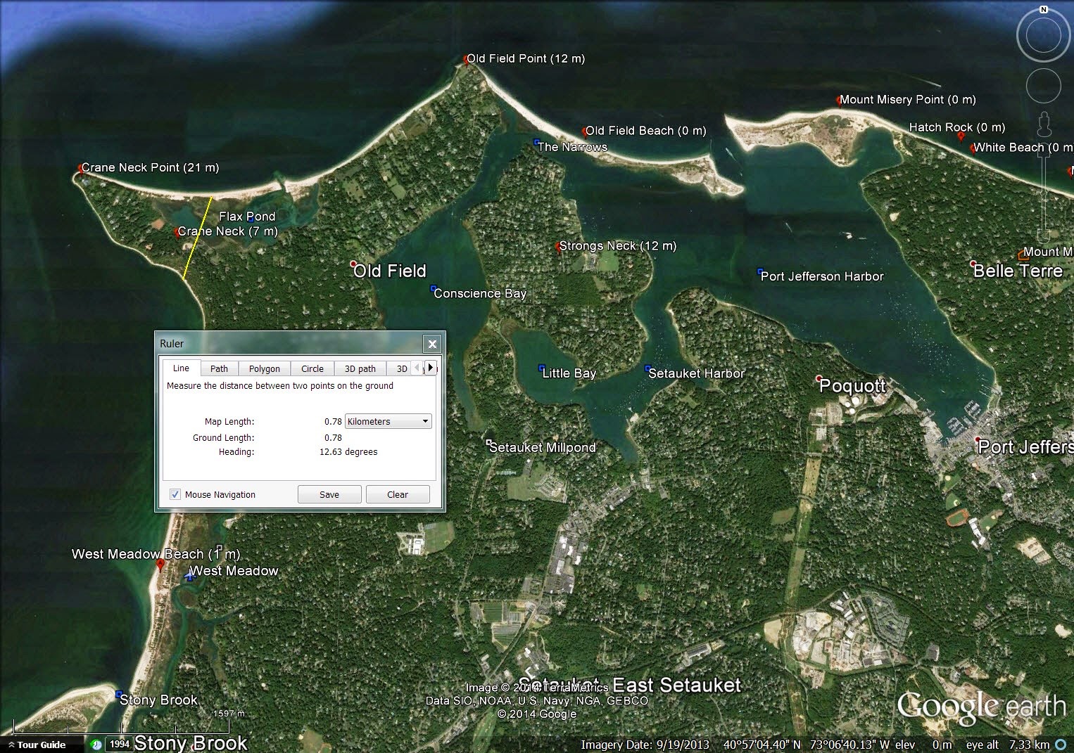
| Crane Neck | Suffolk County, NY | 1 salt 2 salt | 0.78 |
| Curles Neck | Henrico County, VA | 1 fresh 2 fresh 3 fresh | 2.30 |
| Custis Neck | Accomack County, VA | 1 fresh 2 fresh 3 estuary | 1.72 |
| Eagle Neck | McIntosh County, GA | 1 estuary 2 estuary 3 estuary | 1.41 |
| Eaglehawk Neck | Tasmania, Australia | 1 salt 2 salt | 0.11 |
| East Neck | Suffolk County, NY | 1 salt 2 salt 3 salt | 3.00 |
| Eastern Neck | Norfolk County, MA | 1 salt 2 salt | 0.18 |
| Eatons Neck | Suffolk County, NY | 1 salt 2 salt 3 salt | 1.64 |
| Elk Neck | Cecil County, MD | 1 salt 2 salt | 7.83 |
| Elliotts Neck | Northampton County, VA | 1 estuary 2 estuary | 1.89 |
| Eyrehall Neck | Northampton County, VA | 1 salt 2 salt 3 salt | 0.89 |
| Eyreville Neck | Northampton County, VA | 1 salt 2 salt 3 salt | 0.92 |
| Finneys Neck | Accomack County, VA | 1 estuary 2 estuary 3 estuary | 0.67 |
| Glebe Neck | Middlesex County, VA | 1 fresh 2 fresh | 0.30 |
| Gravel Neck | Surry County, VA | 1 estuary 2 salt 3 salt | 2.77 |
| Great East Neck | Suffolk County, NY | 1 fresh 2 fresh 3 salt | 1.05 |
| Great Neck | Accomack County, VA | 1 estuary 2 estuary | 0.22 |
| Great Neck | Bristol County, MA | 1 fresh 2 fresh 3 fresh | 1.08 |
| Great Neck | Essex County, MA | 1 fresh 2 fresh 3 estuary | 0.75 |
| Great Neck | Nassau County, NY | 1 salt 2 salt | 3.13 |
| Great Neck | Northampton County, VA | 1 estuary 2 salt | 0.39 |
| Great Neck | Suffolk County, NY | 1 fresh 2 fresh 3 salt | 1.37 |
| Hacks Neck | Accomack County, VA | 1 estuary 2 estuary 3 salt | 3.41 |
| Harris Neck | McIntosh County, GA | 1 estuary 2 estuary | 0.75 |
| Hog Neck | Accomack County, VA | 1 fresh 2 fresh 3 estuary | 1.72 |
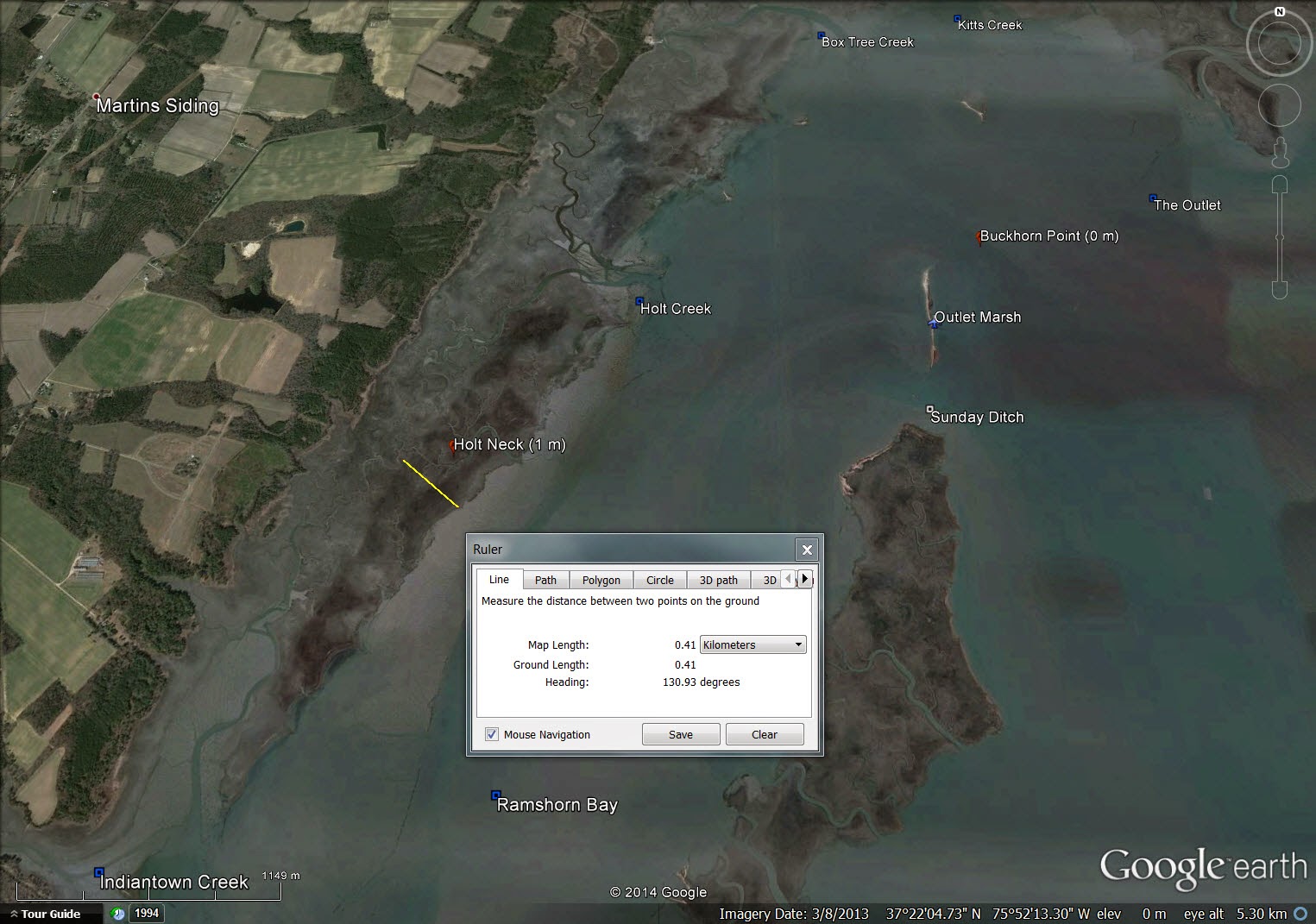
| Holt Neck | Northampton County, VA | 1 estuary 2 estuary | 0.41 |
| Horton Neck | Suffolk County, NY | 1 salt 2 salt 3 salt | 1.07 |
| Houghs Neck | Norfolk County, MA | 1 salt 2 salt 3 salt | 0.31 |
| Indian Neck | Barnstable County, MA | 1 estuary 2 estuary 3 salt | 0.40 |
| Indiantown Neck | Northampton County, VA | 1 estuary 2 estuary 3 estuary | 1.96 |
| Johns Neck | Suffolk County, NY | 1 fresh 2 salt 3 salt | 2.76 |
| Jones Neck | Chesterfield County, VA | 1 fresh 2 fresh 3 fresh | 0.94 |
| Joynes Neck | Accomack County, VA | 1 fresh 2 estuary 3 estuary | 1.59 |
| Knotts Neck | Suffolk, VA | 1 fresh 2 fresh 3 salt | 1.23 |
| Little East Neck | Suffolk County, NY | 1 fresh 2 estuary 3 salt | 0.59 |
| Little Neck | Essex County, MA | 1 estuary 2 estuary 3 estuary | 0.31 |
| Little Neck | Queens County, NY | 1 fresh 2 salt | 0.73 |
| Little Neck | Suffolk County (north), NY | 1 salt 2 salt | 0.52 |
| Little Neck | Suffolk County, NY | 1 fresh 2 fresh 3 salt | 0.76 |
| Lloyd Neck | Suffolk County, NY | 1 salt 2 salt 3 salt | 2.36 |
| Long Neck | Sussex County, DE | 1 estuary 2 estuary | 2.10 |
| Lower Neck | Norfolk County, MA | 1 salt 2 salt 3 salt | 0.18 |
| Machodoc Neck | Westmoreland County, VA | 1 estuary 2 salt 3 salt | 1.63 |
| Marlborough Neck | Stafford County, VA | 1 fresh 2 fresh 3 estuary | 1.48 |
| Mathias Point Neck | King George County, VA | 1 estuary 2 salt 3 salt | 2.47 |
| Middle Neck | between Rappahannock & York Rivers, VA | 1 estuary 2 estuary 3 salt | 19.75 |
| Mill Neck | Nassau County, NY | 1 estuary 2 estuary 3 salt | 1.36 |
| Milners Neck | Suffolk, VA | 1 fresh 2 fresh | 1.64 |
| Mondays Neck | Northumberland County, VA | 1 fresh 2 estuary 3 estuary | 0.48 |
| Narrow Neck (earliest) | Aukland, New Zealand | 1 estuary 2 salt | 0.11 |
| Narrow Neck | Aukland, New Zealand | 1 estuary 2 salt | 1.02 |
| Narrow Neck | New South Wales, Australia | knifepoint mountain ridge | 0.85 |
| Narrowneck | Queensland, Australia | 1 fresh 2 salt | 0.09 |
| Newport Neck | Worcester County, MD | 1 estuary 2 estuary | 1.18 |
| Northern Neck | between Potomac & Rappahannock Rivers, VA | 1 estuary 2 estuary 3 salt | 12.01 |
| Occohannock Neck | Northampton County, VA | 1 estuary 2 salt | 2.90 |
| Old Neck | Northampton County, VA | 1 estuary 2 estuary 3 salt | 0.46 |
| Old Neck | Suffolk County, NY | 1 estuary 2 estuary 3 salt | 0.50 |
| Old Town Neck | Northampton County, VA | 1 fresh 2 fresh 3 salt | 1.29 |
| Parker Neck | Accomack County, VA | 1 fresh 2 fresh 3 estuary | 2.06 |
| Pecatone Neck | Westmoreland County, VA | 1 estuary 2 estuary 3 salt | 1.17 |
| Pine Pole Neck | Pender County, NC | 1 fresh 2 fresh | 5.51 |
| Porters Neck | New Hanover County, NC | 1 fresh 2 fresh 3 estuary | 2.55 |
| Quaker Neck | Suffolk, VA | 1 fresh 2 fresh | 1.61 |
| Salem Neck | Essex County, MA | 1 salt 2 salt 3 salt` | 0.48 |
| Sampawams Neck | Suffolk County, NY | 1 estuary 2 estuary 3 salt | 0.73 |
| Santapogue Neck | Suffolk County, NY | 1 fresh 2 estuary 3 salt | 0.81 |
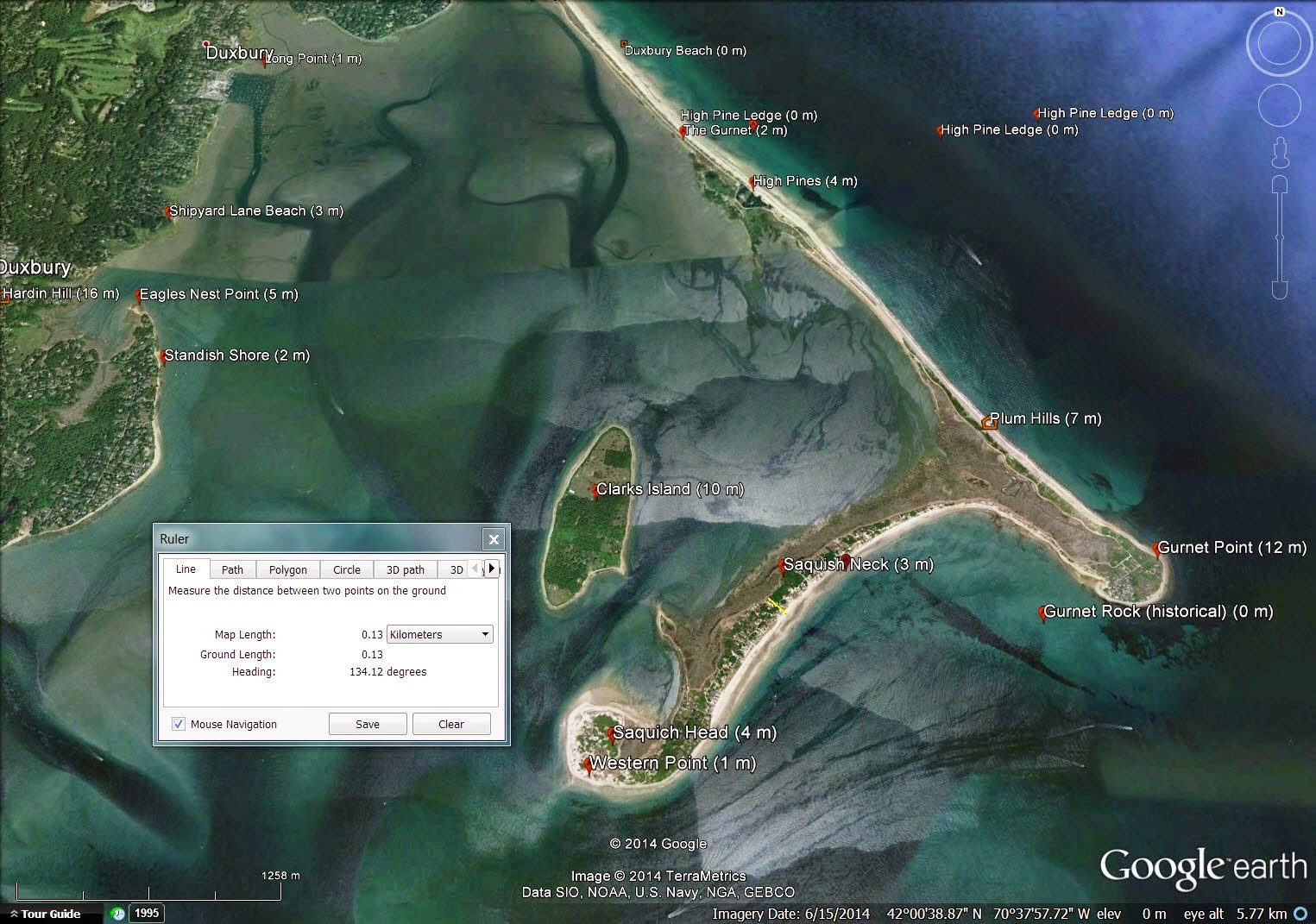
| Saquish Neck | Plymouth County, MA | 1 salt 2 salt | 0.13 |
| Savage Neck | Northampton County, VA | 1 estuary 2 salt | 1.30 |
| Scarborough Neck | Accomack County, VA | 1 estuary 2 estuary 3 salt | 1.41 |
| Sconticut Neck | Bristol County, MA | 1 salt 2 salt | 0.33 |
| Scotland Neck | Halifax County, NC | 1 fresh 2 fresh | 8.29 |
| Scotland Neck | Surry County, VA | 1 fresh 2 estuary 3 salt | 1.66 |
| Sluitkill Neck | Accomack County, VA | 1 estuary 2 estuary 3 salt | 2.07 |
| Smith Neck | Bristol County, MA | 1 fresh 2 fresh 3 salt | 2.92 |
| Smith Neck | Isle of Wight County, VA | 1 estuary 2 estuary 3 estuary | 0.72 |
| Stodders Neck | Plymouth County, MA | 1 estuary 2 salt 3 salt | 0.15 |
| Stove Point Neck | Middlesex County, VA | 1 salt 2 salt | 0.19 |
| Strongs Neck | Suffolk County, NY | 1 salt 2 salt 3 salt | 0.35 |
| Timber Neck | Middlesex County, VA | 1 estuary 2 estuary 3 salt | 1.01 |
| Timber Neck | Surry County, VA | 1 fresh 2 fresh | 0.59 |
| Upper Neck | Norfolk County, MA | 1 salt 2 salt | 0.24 |
| Upshur Neck | Accomack County, VA | 1 estuary 2 estuary | 0.85 |
| Virginia aka Southern Neck | between York & James Rivers, VA | 1 estuary 2 estuary 3 salt | 8.31 |
| Walnut Neck | Suffolk County, NY | 1 salt 2 salt | 0.53 |
| Wellington Neck | Northampton County, VA | 1 estuary 2 estuary | 0.97 |
| West Neck | Suffolk County (north), NY | 1 salt 2 salt 3 salt | 2.35 |
| West Neck | Suffolk County, NY | 1 salt 2 salt | 1.16 |
| Weyanoke Neck | Charles City County, NY | 1 fresh 2 fresh | 2.89 |
| Whites Neck | Accomack County, VA | 1 estuary 2 estuary 3 estuary | 1.57 |
| Wilson Neck | Northampton County, VA | 1 estuary 2 estuary | 2.41 |
| Yeo Neck | Accomack County, VA | 1 estuary 2 estuary 3 estuary | 1.19 |
| Mean Width | | | 2.00 |
| Median Width | | | 1.18 |
| Minimum Width | | | 0.09 |
| Maximum Width | | | 19.75 |
| Fresh count | | | 80 |
| Estuary count | | | 103 |
| Salt count | | | 109 |
During the colonial era, English speakers used the word "neck" to identify small to medium-sized peninsulas or land bridges surrounded by any combination of rivers, inlets, tidal basins, bays, sounds or oceans. Some necks in our sample (41/115) have 2 sides terminating in a point such as Crane Neck on Long Island.
![]() |
| Crane Neck, Suffolk County, New York |
We classify Crane Neck as type 1 salt 2 salt meaning it has 2 sides, both exposed to salt water. The yellow line on the map above shows the point at which we took our width measurement, .78 km.
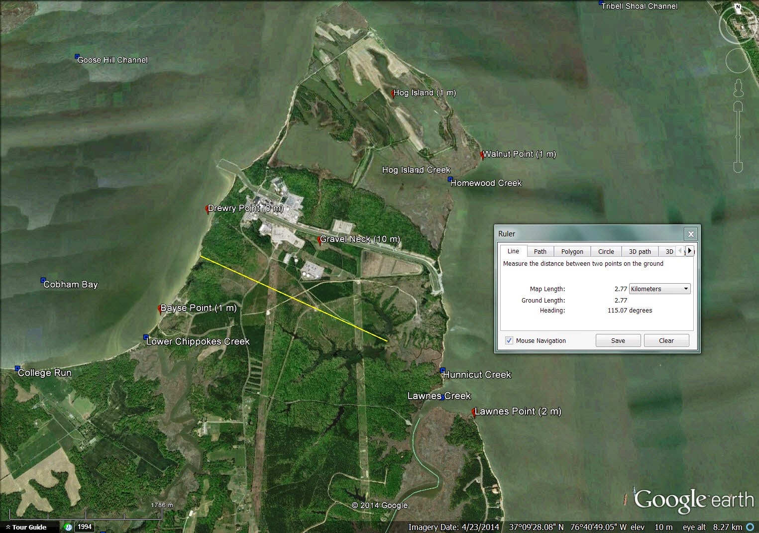
Other necks (74/115) have 3 sides such as Gravel Neck jutting into Chesapeake Bay.
![]() |
| Gravel Neck, Surry County, Virginia |
We classify Gravel Neck as type 1 estuary 2 salt 3 salt meaning it has 3 sides with the first bounding an estuary and the other two exposed to salt water. Gravel neck is 2.77 km wide at the point indicated.
Most necks in our sample (113/115) are peninsular land forms protruding from a larger land mass such as Eastern Neck near Weymouth, Massachusetts which has Lower Neck protruding from it and Upper Neck protruding from Lower Neck.
![]() |
| Eastern Neck, Norfolk County, Massachusetts |
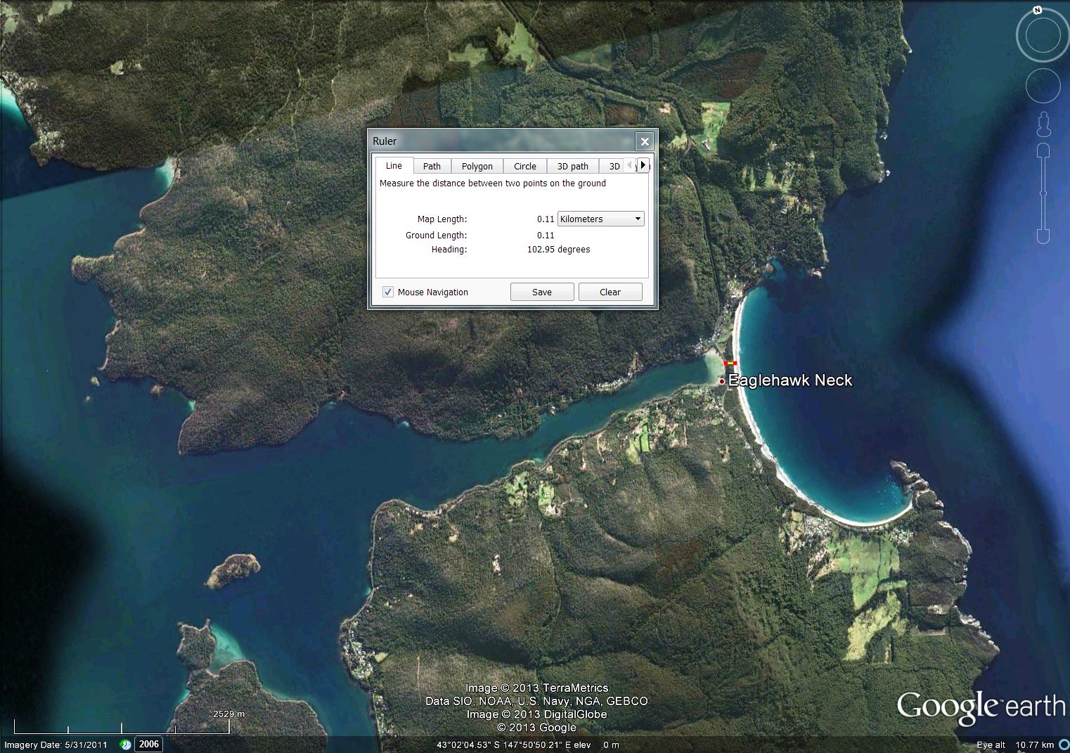
Two necks in our sample are isthmian land forms bridging two much larger land masses. One of those is Eaglehawk Neck in extreme southern Australia. Eaglehawk Neck, .11 km wide, is the second narrowest neck in our sample.
![]() |
| Eaglehawk Neck, Tasmania |
The other is Narrowneck Beach on Australia's famed Gold Coast near Brisbane. Narrowneck Beach is a .09 km wide tongue of land between the Pacific Ocean to the east and a small branch of the Nerang River to the west. Narrowneck Beach is the narrowest neck in our sample.
![]() |
| Narrowneck, Queensland |
Both examples of isthmian necks are from Australia whose English settlement began in 1788 when the First Fleet sailed into Botany Bay (modern Sydney) and founded a penal colony.
One of our sample necks is not surrounded by water. Narrow neck near Katoomba, Australia is a cliff-lined sandstone peninsula less than 1 km wide separating Jamison Valley on the east from Magalong Valley on the west.
![]() |
| Narrow Neck, New South Wales shown with 3X vertical exaggeration |
The other 114 necks of land in our sample are surrounded by some combination of fresh, estuarial and salt water. We have classified 16 different combinations:
| Neck Type | Count |
| 1 fresh 2 fresh | 9 |
| 1 fresh 2 fresh 3 fresh | 4 |
| 1 fresh 2 estuary | 3 |
| 1 fresh 2 fresh 3 estuary | 8 |
| 1 fresh 2 estuary 3 estuary | 3 |
| 1 fresh 2 salt | 3 |
| 1 fresh 2 fresh 3 salt | 13 |
| 1 fresh 2 estuary 3 salt | 3 |
| 1 fresh 2 salt 3 salt | 1 |
| 1 estuary 2 estuary | 10 |
| 1 estuary 2 estuary 3 estuary | 9 |
| 1 estuary 2 salt | 5 |
| 1 estuary 2 estuary 3 salt | 13 |
| 1 estuary 2 salt 3 salt | 5 |
| 1 salt 2 salt | 12 |
| 1 salt 2 salt 3 salt | 13 |
| Total | 114 |
It is obvious from these counts that our sample tends strongly toward estuarial and salt waters.
Nine of the necks of land in our study carry diminutive names (the words "little" or "narrow") implying small size. As we would expect, the mean width of these nine is significantly smaller (.55 km) than the mean width of the entire sample set (2.0 km).
Thirteen of the necks of land in our study carry augmentative names (the words "big,""broad,""great," or "long) implying large size. As we would expect, the mean width of these thirteen is significantly larger (3.88 km) than the mean width of the entire sample set (2.0 km).
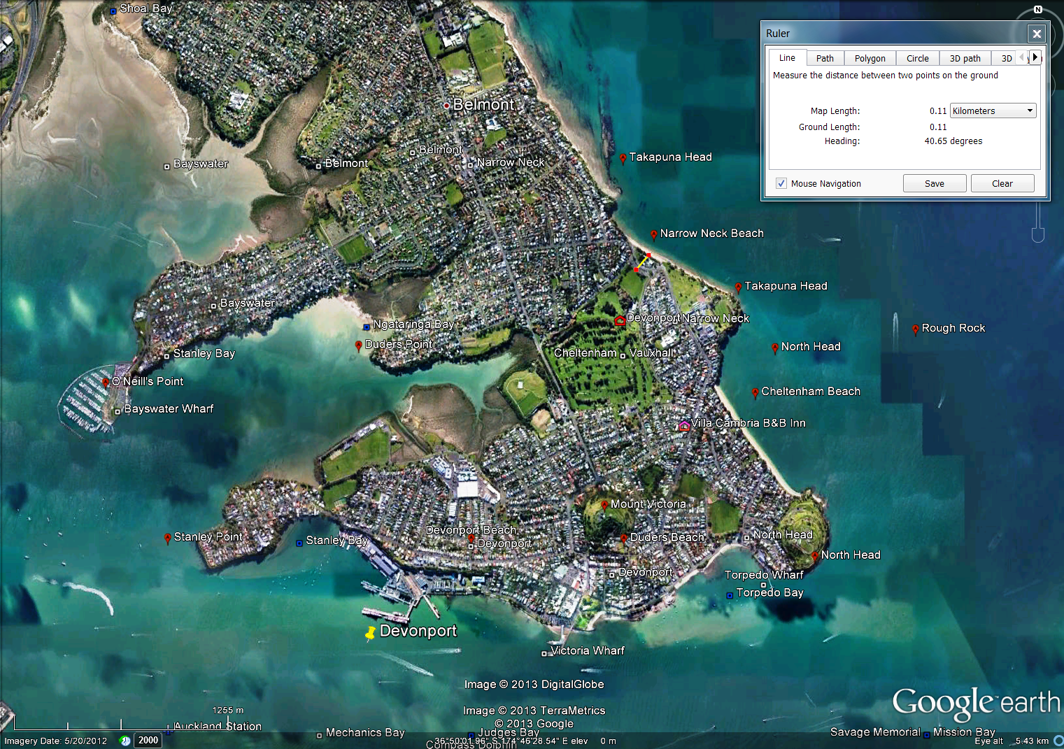
Of course we're interested in any neck of land that includes the word "narrow" in its name. Two examples from Australia are illustrated above. A third is from Devonport Peninsula on Aukland, New Zealand's north shore. Originally this peninsula had a very narrow (.11 km wide) causeway and beach separating its north and south components, with a large mangrove swamp to the west. This small strip of land was called "Narrow Neck. In the 1850's, the swamp was drained and a racetrack constructed. Today the reclaimed land is a golf course, Narrow Neck is an Aukland suburb with about 3,600 inhabitants and a popular urban beach.
![]() |
Narrow Neck, Aukland. The width measures the causeway before
the swamp was drained and the land to the west reclaimed |
Conclusions.Based on our analysis of 115 geographic features English-speaking colonists called a "neck of land" we answer the three questions posed at the beginning of this article and posit three characteristics we will likely find in the Book of Mormon narrow (small) neck of land.
- It will be a peninsula rather than an isthmus. 113/115 of the examples in our study are peninsulas and only 2 are isthmuses.
- It will be on the order of 2.0 km wide. Our 115 examples average 2.0 km in width.
- It will front salt water and estuarial water. 101/115 examples in our study have an exposure to the sea or an estuary
Correlations.The Isthmus of Tehuantepec fails 2 of our 3 criteria.
- It is an isthmus.
- It is 216 km wide.
- It fronts both the open ocean and estuaries.
Barra San Marcos near Tonala, Chiapas, our proposed narrow (small) neck of land, fits all 3 criteria beautifully.
![]() |
| Barra San Marcos, Tonala, Chiapas |
- It is a peninsula.
- It is 2.0 km wide.
- The seaward side fronts the Pacific Ocean, while the landward side fronts an extensive network of estuarial lagoons.
Furthermore, a number of the necks of land in our study have physical characteristics quite similar to Barra San Marcos. Examples include:
![]() |
| Bell Neck, Accomack County, Virginia |
![]() |
| Bradford Neck, Accomack County, Virginia |
![]() |
| Brickhouse Neck, Northampton County, Virginia |
![]() |
| Great Neck, Accomack County, Virginia |
![]() |
| Harris Neck, McIntosh County, Georgia |
![]() |
| Holt Neck, Northampton County, Virginia |
![]() |
| Saquish Neck, Plymouth County, Massachusetts |
![]() |
| Upshur Neck, Accomack County, Virginia |


%2BNeck%2C%2BVA%2B1751.jpg)


%2C%2BAukland%2C%2BNZ.png)