Quantcast
Channel: BOOK of MORMON RESOURCES
Viewing all 358 articles
Browse latest View live

Narrow and Small Things

$
0
0
This article will analyze all 17 occurrences of the word "narrow," all 10 occurrences of the word "strait" and all 50 occurrences of the word "small" in the Book of Mormon text in an attempt to deduce the meanings of those terms in Nephite usage.
1. 1 Nephi 8:20, 2 Nephi 31:18, and 2 Nephi 31:19 all describe a strait and narrow path that leads by a rod of iron along a river of water toward the tree of life. People press forward along this path, holding on to the rod of iron 1 Nephi 8:241 Nephi 8:30. In this context, the words "narrow" and "strait" connote a distance probably less than 5 meters wide.
2, Helaman 3:29 employs similar wording to describe a strait and narrow course leading across an awful gulf. The scriptural imagery suggests a foot bridge crossing a canyon, wide enough for a single pedestrian. In this context, the words "narrow" and "strait" connote a distance probably less than 5 meters wide.
3. 2 Nephi 9:41 introduces the idea of a gate one must go through to access a narrow way or path leading to the Lord and life. 2 Nephi 31:9 and 2 Nephi 33:9 use the words "narrowness" and "narrow" to describe the gate and the words "straitness" and "strait" to describe the path. The more common Book of Mormon usage reverses the word order so the gate is "strait" and the way is "narrow" Jacob 6:11, 3 Nephi 14:14, 3 Nephi 27:33. The gate and the way are restrictive enough that few people find them. In this context, the words "narrow" and "strait" connote a distance probably less than 5 meters wide.
4. 3 Nephi 14:13 and 3 Nephi 27:33 further clarify that "strait" is an antonym of "wide" and "narrow" is an antonym of "broad." A wide gate and a broad way can accommodate many people while a strait gate and a narrow way admit only a few. These texts are straightforward. The word "narrow" describes a distance on a human scale, something on the order of a few meters in width.

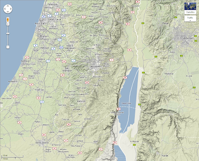
Other passages, though, expand our view. 1 Nephi 21:19-20 comes from the 49th chapter of Isaiah which describes the future gathering of the House of Israel following the Assyrian destruction of the northern kingdom ca. 720 B.C. When Joshua (from the tribe of Ephraim 1 Chronicles 7:27) allocated territory to the tribes following the Israelite conquest of Palestine, the house of Joseph (Ephraim and Manasseh) complained that their lands west of Jordan were too small for their large populations Joshua 17:14. Joshua gave them the opportunity to acquire additional territory through military conquest Joshua 17:15. In this text the word "narrow" describes the trans-Jordan land originally allotted to the tribes of Ephraim and Manasseh. This map of Palestine will help quantify the Josephites' complaint.
Map of Palestine with distances noted
Dan to Beersheba was the Biblical transect representing the entire north to south extension of the Israelite nation Judges 20:1 (and 9 other Old Testament references). This is a straight line (air) distance of 235 kilometers. The land originally granted to the tribes of Ephraim and one-half of Manasseh extended from Bethel in the south to the Plains (or Valley) of Jezreel in the north. This is a distance of 65 kilometers. The original land grant to this portion of the house of Joseph was west of Jordan, so a reasonable approximation of the size of their territory would be 70 kilometers X 70 kilometers or approximately 4,900 square kilometers. This is larger than the state of Rhode Island (4,002 square kilometers) and slightly smaller than Utah County, Utah (5,188 square kilometers). The sense of Joshua 17:15, then, is that the house of Joseph considered a land area of approximately 4,900 square kilometers insufficient ("too narrow") for 2 (actually 1.5) of the largest tribes of Israel. Isaiah 49 (1 Nephi 21) describes the glorious future return of the dispersed tribes of Israel. They will "inherit the desolate heritages" 1 Nephi 21:8 or in other words, re-inhabit the lands originally granted to them. Their numbers will be so great that like Ephraim and Manasseh of old, they will complain that their allotted lands are "too narrow" and "too strait" 1 Nephi 21:19-20 for their large populations. The original territory assigned by Joshua to all 13 (Joseph received a double portion Joshua 14:4) of the tribes of Israel on both sides of Jordan was on the order of 25,000 square kilometers. This is approximately the size of the state of Vermont (24,901 square kilometers) and somewhat larger than San Juan County, Utah (20,254 square kilometers). So, the sense of 1 Nephi 21:91-20 is that the returning house of Israel in the last days will find even the entire original land of Israel inadequate ("too narrow," "too strait") for their numbers.

There is a fundamental difference between the "narrow" and "strait" things discussed in points 1-4 above and the use of those terms in Isaiah 49 (1 Nephi 21) and Joshua 17. When the scriptures call a gate, path, way or course "narrow" or "strait" the words are simple adjectives describing an intrinsic characteristic of the nouns "gate", "path", "way" or "course." When the scriptures describe a geographic region as "too narrow" for a given large population, the word "too" is an adverb modifying the adjective "narrow" under a certain condition "by reason of the inhabitants" 1 Nephi 21:19. The same pattern holds in the next verse where the word "too" is an adverb modifying the adjective "strait" under a certain condition "for me" 1 Nephi 21:20 meaning for the entire returning house of Israel in the last days. Does the Book of Mormon or the Old Testament ever use the terms "narrow" or "strait" to describe an intrinsic characteristic of an extension of territory as large as the Holy Land or some region within it? No. On the contrary, after Joshua had destroyed dozens of the kingdoms whose lands the Israelites inherited, the Lord spoke to his prophet and described the regions still unconquered as "very much land" Joshua 13:1. The entire territory divided among the tribes of Israel is called variously:
  • "the country" Joshua 19:51 (and dozens of other references, variant reading "this country")
  • "all the land" Joshua 21:43 (and many other references, variant reading "all this land")
  • "the good land" Joshua 23:16 (and many other references, variant reading "this good land")
  • "the land" Judges 2:1 (and dozens of other references, variant reading "this land")
When the tribe of Dan conquered Laish and established their eponymous city in its place, they described the surrounding region as "a large land" Judges 18:10.

So, the sense of 1 Nephi 21:19-20 does not imply that the Israelites considered any portion of their territory in Palestine inherently "narrow" or "strait."

This concludes our analysis of the word "strait" in the Book of Mormon. We are ready to examine some very interesting things that are "narrow."

5. A narrow strip of wilderness Alma 22:27 ran from the sea east by the head of Sidon to the sea west dividing the greater land of Zarahemla on the north from the greater land of Nephi on the south. In a parallel text Alma 50:11, Mormon described this Nephite/Lamanite boundary as a "line" running from the west sea by the head of Sidon with the greater land of Nephi on the south and the greater land of Zarahemla on the north. In ca. 72 B.C., the Nephite city of Moroni was built just north of this line Alma 50:13. How wide might this narrow strip or line of wilderness have been? Wilderness by its very nature would be wider than any man-made feature such as a road or wall. A few kilometers seems reasonable. Could anything much wider than 5 kilometers qualify as intrinsically narrow? It could hardly be considered a line. The demilitarized zone (DMZ) separating North and South Korea is generally considered a "strip" rather than a "narrow strip." It is 4 kilometers wide running 250 kilometers from sea to sea with a line, the military demarcation line (MDL), running right down the middle. In the article "Land Southward Travel Times" in this blog, we analyze a number of known historical journeys to deduce a reasonable distance in straight line (air) kilometers for the standard Nephite measure one day's travel. Our resulting rule of thumb is 15 kilometers. If the narrow strip of wilderness averaged 5 kilometers in width a typical Nephite could cross it in one third of a day. That seems reasonable for a physio-graphic feature continental in scope. In this context, the  narrow strip of wilderness probably did not exceed 5 kilometers in width.          
6. A strategic narrow pass Alma 50:34; Alma 52:9; Mormon 3:5 led between the land southward and the land northward, at the border between the lands of Bountiful on the south and Desolation on the north. This pass led by the seacoast. It had salt water to the west and more salt water to the east. It was a small enough place that a Nephite army numbering in the hundreds, perhaps thousands, certainly not tens of thousands could secure it against Lamanite attack. When major battles were fought there near the end of the Nephite era, enemy dead were cast into the sea. It sounds like a place with saltwater lagoons or tidal flats where a spur from a coastal mountain range reaches almost to the water's edge. In order to fit these criteria, the narrow pass could not have been more than 1 or 2 kilometers wide at most, with a few dozen or hundreds of meters more likely.
7. A narrow neck of land Alma 63:5; Ether 10:20 led between the land southward and the land northward, at the border between the lands of Bountiful on the south and Desolation on the north. This narrow neck was on the west seacoast at a point where salt water created a division between stretches of dry land. Ocean-going vessels launched nearby. It sounds like a sand bar running along a seacoast fronting an inter-coastal waterway or a series of saltwater lagoons. How large are known necks of land? A cemetery in Taunton, Bristol County, Massachusetts, established in 1687, is called the "Neck of Land Cemetery." The neck refers to land between the Taunton and Mill (aka Little) Rivers. On this 1858 map, the cemetery is circled in red.
Neck of Land Cemetery, Taunton, Massachusetts
Locating the same area on Google Earth allows us to measure the width of this neck of land.
Closeup of Neck of Land Cemetery, Taunton, Massachusetts
Setting a ruler in Google Earth, we see that the distance between rivers across this neck is .22 kilometers or 220 meters.

North east of Joplin, Missouri is a small town named Neck City. Located near the point where Duval Creek and the North Fork of Spring River come close enough to form a neck of land, Neck City was once a mining boom town called "Hell's Neck."
Neck City, Missouri
The neck of land between 2 streams that gives Neck City its name is .62 kilometers or 620 meters wide.

A single river can also form a neck of land. In Halifax County, North Carolina, the Roanoke River makes a loop known locally as "the neck." The town of Scotland Neck derives its name from a group of Scottish immigrants who in 1722 settled near the neck of the Roanoke.
Scotland Neck, North Carolina
At the points indicated on the map, the neck of the Roanoke River is 8.29 kilometers wide.

In Herefordshire, UK, a meander in the Wye River creates a landform the British call a "neck of land."
Wye River Neck of Land, Herefordshire, UK
The distance across the base of this neck is .49 kilometers or 490 meters.

Highway 682 in Williamsburg, Virginia is called "Neck-o-Land Road." The neck in this case is land between 2 streams. Neck-o-Land Road is highlighted in red on the map below.
Neck-o-Land Road, Williamsburg, Virginia
This particular neck of land is 1.05 kilometers wide at the points indicated.

A peninsula jutting from Long Island, New York is called Great Neck. At its base a much smaller peninsula is called Little Neck. This image shows a ruler across Great Neck. Little Neck is circled in red.
Little Neck (in red) and Great Neck, New York
Little Neck is about 470 meters wide. Great Neck measures 3.13 kilometers at its narrowest point.

Virginia has 3 peninsulas traditionally called necks all bounded by Chesapeake Bay on the east. Northern Neck borders the Potomac River on the north and the Rappahannock River on the south. Middle Neck (Middle Peninsula) has the Rappahannock River on the north and the York River on the south. Southern Neck (Virginia Peninsula) lies between the York River on the north and the James River on the south. This image shows all 3 necks with a ruler measuring the width of Northern Neck.
Northern, Middle & Southern Necks, Virginia
At the points indicated on the ruler, Virginia's Northern Neck is 23 kilometers wide. At its narrowest point near George Washington Birthplace National Monument, Northern Neck is 7.5 kilometers wide.

The wetlands of coastal Georgia contain many tiny island landmasses called necks. We will focus on one in McIntosh County called Harris Neck.
Harris  Neck, Georgia
Harris Neck is 10 kilometers long and .75 kilometers wide at its narrowest point. Surrounded by swamps, it serves today as a National Wildlife Refuge. Notice the triangular shape on the north west corner. During WWII those were the runways of an active army airfield.

Crabtree Neck is a peninsula in Hancock County, Maine.
Crabtree Neck, Maine
At the points marked by the ruler, Crabtree Neck is 2.24 kilometers wide.

Delaware's two large inland bays, Rehoboth Bay on the north and Indian River Bay on the south, are separated by Long Neck, a peninsula that almost connects with the coastal beaches.
Long Neck, Delaware
Long Neck is 2.1 kilometers wide near the base.

Elk Neck, Maryland is a peninsula jutting into the northern part of Chesapeake bay.
Elk Neck, Maryland
Elk Neck is 7.83 kilometers wide at its base.

Devonport is a northern suburb, across Waitemata Harbor from Aukland, New Zealand. It used to be connected to the rest of the North Shore by a causeway called the "Narrow Neck." Narrow Neck Beach lay to the east and large mangrove swamps to the west. About 150 years ago, the locals drained the swamps  and reclaimed the land which today is a golf course. This image has a small ruler measuring the width of the causeway prior to reclamation.
Narrow Neck, New Zealand
The causeway that New Zealanders called their "Narrow Neck" was 110 meters wide before reclamation. The contemporary town of Narrow Neck was named after it.

Eaglehawk Neck, Tasmania connects the Tasman Peninsula with the rest of the island.
Eaglehawk Neck, Tasmania
Eaglehawk Neck is 110 meters wide.

A neck of land can also be created by political boundaries. The Siliguri Corridor is a stretch of land connecting India's north eastern states to the rest of the country. 22.90 kilometers wide, the corridor is bounded on the west by Nepal and on the east by Bangladesh. Contemporary Indians call it "Chicken's Neck."
Siliguri Corridor (Chicken's Neck), India
Pakistan also has its Chicken's Neck. The Akhnoor Dagger, commonly called Chicken's Neck, is a narrow strip of Pakistan plunging into Indian-controlled Kashmir.
Akhnoor Dagger (Chicken's Neck), Pakistan
Pakistan's neck of land measures 2.50 kilometers wide at the base.

Geographers call a neck of land connecting two larger landmasses an "isthmus." Our English word derives from the Greek isthmos meaning "neck." Was the Book of Mormon narrow neck of land an isthmus? Not necessarily. The examples above (and there are dozens of others we could have included such as Land's End in Cornwall, UK) show that landforms commonly called necks are formed by:
  • 2 streams of water running in close proximity to each other
  • Meanders in a single stream of water
  • Peninsulas jutting out from the mainland
  • Wave action building up sand bars along shore lines or in tidal flats
  • Political boundary making
  • Causeways or isthmuses connecting two land masses
The Isthmus of Tehuantepec in southern Mexico has been identified so frequently over the years as the Book of Mormon's narrow neck of land that isthmuses deserve special attention. See the article entitled "Isthmuses" in this blog for relevant information about the Tehuantepec area and an analysis of 52 prominent isthmuses around the world. The result: Tehuantepec, at 216 kilometers, is the widest isthmus on earth. It is so large that some geographic authorities do not consider it an isthmus at all, but rather part of a continental landmass. The narrowest quartile of isthmuses in our study ranged in width from 40 meters to 250 meters. The second quartile ranged from 370 meters to the median width of 2.96 kilometers. The third quartile ranged from 3.75 to 12 kilometers in width. This means that three fourths of the 52 isthmuses in our sample were 12 kilometers wide or less and seven eighths were 30 kilometers wide or less. Where does this leave an isthmus 216 kilometers from sea to sea? In a class by itself. Off the charts. An outlier orders of magnitude removed from the median and the mean. Does the description "narrow neck of land" fit the Isthmus of Tehuantepec? No, for several reasons.
  • Scriptural use of the word "narrow" as an unmodified adjective in either the Book of Mormon or the Old Testament describing the objects gate, path, way, course, strip of wilderness, or pass reference sizes from a few meters to perhaps 5 kilometers in width. Anything wider than 5 kilometers begins to be problematic when the relevant passages are read in context. When the Nephites used the word "narrow" as an adjective, they were probably referring to something 5 kilometers wide or snaller.
  • We analyzed 15 known examples of land forms called a "neck." Our examples come from 6 different countries. Widths range from 110 meters to 23 kilometers. When English speakers use the word "neck" to describe a strip of land, they generally do not have in mind anything wider than 23 kilometers. In order to qualify as a "narrow neck of land" a neck should probably not exceed 5 kilometers in width.
  • Based on a sample of 52 isthmuses around the world, in order to qualify as a "narrow neck of land" an isthmus should probably not exceed the median width of 2.96 kilometers.  
8. A narrow passage Mormon 2:29 led between the land northward and the land southward, which means it was at the border between the lands of Bountiful on the south and Desolation on the north. This narrow passage may be the same geographic feature as the narrow pass referenced in point #6 above. Whether one considers it a unique land form or another name for the narrow pass, this feature probably did not exceed 1 or 2 kilometers in width with a few dozen or hundreds of meters more likely.

This concludes our look at every use of the word "narrow" in the Book of Mormon. We now have the delicious opportunity to examine what the Nephites meant by the word "small."

1. The voice of an angel 1 Nephi 17:45 and the voice of the Lord 3 Nephi 11:3 can both be small.
2. In the last days, the church of the Lamb of God will have small holdings and influence around the world 1 Nephi 14:12 compared with the much larger and more powerful church of the devil. If we take the official membership of The Church of Jesus Christ of Latter-day Saints at the end of 2011 (14,441,346 - Deseret News 2013 Church News Almanac) and divide it by the total population of the planet (7,074,189,326 - U.S. Census Bureau World Population Clock accessed March 23, 2013) we get the number .00204 or in other words 2/10ths of 1%.
3. The 16 transparent stones the brother of Jared held in his hands while he climbed to the top of Mount Shelem Ether 3:1 were small. They probably weighed less than 200 grams (.44 pounds) apiece.
4. The 8 Jaredite barges were small Ether 2:16. Each vessel was the length of a tree Ether 2:17 which probably means from 15 to 35 meters in length. Working with the family sizes given in the book of Ether: Brother of Jared 22 Ether 6:20; Jared 12 Ether 6:20; Friends of Jared and his brother 22 Ether 6:16 we infer that approximately 80 people crossed the ocean in the 8 Jaredite barges, or approximately 10 passengers per barge. Each vessel also carried animals and food stores Ether 6:4 adequate for a 344 day Ether 6:11 voyage .As a point of comparison, the ark of Noah was 300 cubits long Genesis 6:15 or approximately 135 meters. As a second point of comparison, Hagoth's ocean-going ship was exceedingly large and accommodated many passengers with their provisions Alma 63:5-6.
5. Isaiah said the Israelites had disregarded the prophets of God for so long they no longer considered their sins or disobedience a serious problem. It had become a small thing to them to weary (vex) the men God had sent among them 2 Nephi 17:13.
6. The Lord, quoting Isaiah 54, says that he abandoned Israel for a small moment 3 Nephi 22:7, but in the last days he will gather her again. If we take the abandonment of Israel as the ca. 720 B.C. date when the Assyrian destruction of the Northern Kingdom was complete and the gathering as the April 6, 1830 date when The Church of Jesus Christ of Latter-day Saints was formally established on earth, then the "small moment" is about 2,550 years.
7. At the waters of Mormon near the city of Nephi, the young prophet Alma1 hid from King Noah's guards in a thicket of small trees Mosiah 18:5. These trees probably did not exceed 25 meters in height. Large trees in the Guatemalan rain forest canopy are typically 30 to 45 meters high.
8. The founding prophet, Nephi1 called the pointers in the Liahona where divine script appeared from time to time "small means" 1 Nephi 16:29. These minor interventions from God brought about great results. Alma2 took up the same theme when he commissioned his son, Helaman1, to be the Nephite record keeper. Minor miracles from God had kept and would keep the plates of brass and other Nephite metallic records bright and free from decay. By these small means Alma 37:6-7 great and important results would follow. Alma2 then reiterated that the miracles surrounding the Liahona were "small means" that wrought "marvelous works" Alma 37:41. One is reminded of Pres. Monson's remark that "the door of history turns on small hinges" ("Finishers Wanted," Ensign June, 1989).
9. Nephi1 made two set of plates for record keeping. The large plates containing secular history passed down through his own descendants who were the Nephite kings. The small plates containing spiritual matters passed down through his brother Jacob's descendants who were the Nephite priests. Jacob 1:1, Jarom 1:2 and Jarom 1:14 all describe the plates as small. The size of the plates probably does not refer to their physical dimensions, but rather to the number of plates bound together in a volume.
10. Nephite record keepers also described their own and other's writings as small. This was because a) Mormon's writings on his own plates were an abridgment of a much larger Nephite archive 3 Nephi 5:15; b) divine command limited how much from Nephi1's glorious visions could be committed to writing; c) the logistical difficulty of manufacturing and then engraving on plates limited how much could be recorded Jacob 4:2; d) Mormon was under a divine mandate to be concise Mormon 5:9; e) articulating feelings is inherently difficult Alma 26:16; f) any one man, even a prophet, will have limited written output Jacob 7:27; g) the  small plates, by design, were compact compared with Nephi1's large plates Words of Mormon 1:3.
11. "Great and small" is a phrase modifying and illustrating the comprehensive nature of "all things" taught by the risen Lord to the Nephites 3 Nephi 26:1. cf. 1 Samuel 30:19. "Both small and great" also describes all people who will stand before the judgment bar of Christ Mormon 9:13 in a theme repeated by the prophet Moroni Moroni 10:27 at the end of his writings.
12. When internal strife among the Nephites decreased somewhat in the 48th year of the reign of the judges (ca. 44 B.C.) "wars and contentions began to cease, in a small degree" Helaman 3:22.
13. The word "small" appears most frequently in Nephite writ describing a group of people, often in a military context.
  • Mosiah 11:16 In the days of King Noah, Lamanites slew small numbers of Nephites working their fields and tending their flocks. These "small numbers" of Nephite casualties were probably in the range of 5 to 25 people.
  • Mosiah 19:2 After a series of military encounters with the Lamanites, the forces of King Noah were small, having been reduced. They were probably in the range of 500 - 2,000 men at arms. A given population can only support a small percentage of their numbers in active military service at any point in time. One of the most heavily militarized societies the world has ever known, North Korea, has a population of 24,720,000 (CIA World Factbook). According to the U.S.State Department, the country has 1,210,000 active duty military personnel. That means 4.89% of North Koreans are in the armed forces as their full-time jobs, one of the highest ratios known in modern times. The number of people subject to King Noah must have been at least 20,000 and probably did not exceed 40,000. That estimate is based on several metrics: a) The original military expedition Zeniff was part of considered themselves powerful enough to destroy the Lamanite army Mosiah 9:1 in the land of Nephi; b) the population of Zeniff's colony must have been at minimum several thousand to have rebuilt both the city of Nephi and the city of Shilom Mosiah 9:8; c) in their first major battle with the  Lamanites, the Zeniff colony suffered 279 war dead and killed 3,043 of the enemy; d)  in their second major battle with the Lamanites, the Zeniff colony killed an even greater undetermined number of Lamanites Mosiah 10:20; e) by imposing a 20% tax on his subjects, King Noah was able to undertake ambitious public works Mosiah 11:8; f) About 450 of Noah's former subjects Mosiah 18:35 followed Almainto the wilderness. If Noah's subjects numbered 40,000 and Noah's standing army constituted 5% of the population of his kingdom, his "small" forces would have numbered about 2,000 soldiers.   
  • Mosiah 20:2 A small number of Lamanite maidens gathered together in the land of Shemlon to sing and dance. 24 of them were abducted by the wicked priests of King Noah Mosiah 20:5 and taken into the wilderness. Reading these verses in context, it is clear that the "small number" of young women was at least 24 (if the singing and dancing events being described happened on different days) and probably did not exceed 100 (if the events being described all happened on the same day).
  • Mosiah 21:25 King Limhi send a small expeditionary force into the wilderness to search for the land of Zarahemla. In this case, "small number of men" meant 43 Mosiah 8:7
  • Mosiah 28:1 says the four sons of Mosiah and a "small number" of friends approached King Mosiah2 asking permission to undertake a dangerous mission to the Lamanites. In Alma 20:2 we learn the names of 2 of the friends: Muloki and Ammah. Alma 21:13 says Aaron and a "certain number" of his brethren were cast into prison in the land of Middoni, while the remainder of his brethren escaped into surrounding regions. Based on these verses, we infer that the "small number" of Nephite missionaries headed by Ammon, Aaron, Omner and Himni was at least 20 and probably did not exceed 50.
  • Mosiah 29:29 In the Nephite republic instituted by Mosiah2 one of the governmental checks and balances allowed a small number of lower judges to unseat a higher judge who had not judged righteously according to the voice of the people. In this case, the "small number" was probably between 3 on the low end and 9 on the high end. Israelite tradition seated an odd number of judges in a Sanhedrin in order to avoid tie votes (Talmud, tractate Sanhedrin), a tradition that continues to this day in the Supreme Court of the United States.
  • Alma 46:33 Captain Moroni pursued the traitor Amalickiah and his armies into the wilderness south of Manti where most of them were apprehended and forcibly repatriated back to the greater land of Zarahemla. Unfortunately for the Nephites, Amalickiah himself and a small number of his men escaped further south to the land of Nephi where Amalickiah eventually became the Lamanite emperor Alma 47:35. In this case, Amalickiah's "small number" was probably at least 50 but fewer than 500 men.
  • Alma 52:22 Teancum with a small number of men decoyed the Lamanites out of the city of Mulek and led them on a high speed wild goose chase northward up the Nephite east coast. This allowed part of Moroni's larger army to re-occupy the city of Mulek. The number of men Teancum commanded on this special operation must have been at least a few hundred. Otherwise, the entire Lamanite army stationed in Mulek would not have given chase. How many fighters did the Lamanites have in Mulek? Probably a few thousand. They were defending a highly fortified city, and Captain Moroni's fortification design allowed a modest number of men to hold a city as long as they remained inside the defensive perimeter. Teancum's "small number" was likely between 300 and 1,000 men. Lehi's defensive garrison guarding the city of Bountiful probably numbered 2,000 to 3,000. Moroni's larger force was probably in the 10,000 to 20,000 range. This would have put total Nephite troop strength on the north eastern front at roughly 13,000 to 25,000 men. This seems reasonable given the number of men Helaman1 reported (6,000 to 16,000 see the article "Population Sizes & Casualty Counts" in this blog) in his various campaigns on the south western front.
  • Alma 52:27 When Teancum with Lamanites in hot pursuit reached almost to the city Bountiful, Lehi and a small army came south, joined Teancum's forces, and engaged the enemy. Lehi's "small army" was clearly larger than Teancum's "small number of men." A contemporary commander, Helaman1, considered 2,000 reinforcements to be a "small force" Alma 58:12. Applying the logic outlined in the discussion of Alma 52:22 above, Lehi's "small army" probably numbered between 2,000 and 3,000 troops. Did it take that many men to hold one of Captain Moroni's fortified cities against invasion? That is one of the most fascinating questions in all of Nephite military history. See the article "Captain Moroni in Space and Time" in this blog for a detailed discussion of Captain Moroni's military engineering genius and the false sense of security it gave the Nephites until they got experience holding one of their fortified cities against a vastly superior Lamanite force. Inside a fortified city, could a Nephite force of 500 hold off a Lamanite force of 10,000? That would be 1:20 leverage. Given Amalickiah's blitzkrieg from south to north up the Nephite east coast Alma 51:26, the 1:20 ratio seems excessive. 1:10 is more likely. Holding the city Bountiful was an all-important Nephite military objective during Captain Moroni's career. Lehi and his "small army" probably thought they were prepared for a worst case scenario - fending off a Lamanite invasion of 15, 20 or even 25,000 men. Lehi also enjoyed a qualitative advantage. Captain Moroni deployed his best troops in Bountiful Alma 51:31 which is why Alma 52:36 calls them "strong men."
  • Alma 55:6-7 reports the curious incident of Laman, one of the former Lamanite king's guards who fled  from the land of Nephi north into the land of Melek Alma 47:29 when Amalickiah assassinated his sovereign. 9 years later, Laman was a military leader fighting for the Nephites on the north eastern front when Captain Moroni selected him for a special operation. Laman took a small number of his men and they carried wine to the Lamanite guards standing watch over the city of Gid where many Nephite prisoners of war were incarcerated. Since the mission of Laman's small group was to interact with sentries on guard duty, they probably numbered about 10 or 20 men. Any fewer than 10 would have had difficulty transporting very much wine. Any more than 20 would probably have intimidated and frightened the guards.
  • Alma 58:1 In his lengthy epistle to his commanding officer, Captain Moroni, Helaman1 recounted Nephite military campaigns to defend Judea and re-take the cities of Antiparah, Cumeni and Manti. As the 29th year of the judges (ca. 63 B.C.) played out, Manti was the only Nephite city along the south western front still in Lamanite hands. Facing a vastly superior Lamanite force Alma 58:8, the Nephites hoped to decoy the enemy out of their fortified stronghold at Manti by parading small bands of fighting men as tempting targets past the city. Remembering similar Nephite tactics in other cities (Antiparah, Mulek) that had led them into traps, the Lamanites did not fall for the decoy. Like Teancum's "small number" of men at Mulek Alma 52:22,  Helaman1's "small bands" were probably between 300 and 1,000 men.
  • Alma 58:12 While plotting their strategy to re-take Manti, Helaman1 and the other Nephite commanders on the south western front received 2,000 reinforcements from the central government in the local land of Zarahemla Alma 58:8. This "small force" of 2,000 men gave the weary Nephite army a morale boost at a critical point in their long war.
  • Alma 58:16 The Nephite strategy to re-take Manti was to encamp their main army on the wilderness side of the city, with a small number of men hidden in two places just off the beaten path. When the Lamanites pursued the main Nephite army into the wilderness, the two small groups at their rear converged and overpowered first the Lamanite spies following their column and second the guards who had been left behind in the city of Manti. The "small number of men" with Gid were probably a force of 200 to 500 men. Ditto the "small number of men" with Teomner.
  • Alma 58:32 Helaman1 lamented to Captain Moroni that Nephite forces were stretched very thin, that their armies were small to maintain the large amount of territory then under Nephite control. Months earlier, before the siege of Cumeni, this same Helaman1 exulted that the main Nephite army in the south western front was strong Alma 57:6-8. The "strong" army numbered somewhat less than 16,000 men. See the blog article "Population Sizes and Casualty Counts" for the arithmetic behind the 16,000 count. The Nephites then suffered "great loss" in the battle for Cumeni Alma 57:23 and received 2,000 reinforcements Alma 58:8. So, the "small" army also numbered close to 16,000 men. Helaman1's descriptions of strong or small must be taken in context. A force of 16,000 was strong when compared with the hungry Lamanite defenders desperately trying to hold Cumeni. When Lamanite reinforcements arrived from Manti, the Nephite army was not so strong anymore. In fact, the Nephites nearly lost the battle for Cumeni Alma 57:18. With all the Lamanite forces in the south western quarter of the greater land of Zarahemla ammassed in and around the city of Manti, the Nephites' mere 16,000 men were clearly inadequate Alma 58:2 when confronting a foe that was "innumerable" Alma 58:8. After the Nephites liberated Manti, Lamanite military forces abandoned the south western front for a time Alma 58:30. This was the situation when Helaman1 wrote his lament to Captain Moroni. The Nephite military was responsible for defending Judea, Antiparah, the city beyond, Cumeni, Zeezrom and Manti along the southwestern flank of the greater land of  Zarahemla, plus all points north of that southern tier. If it required 2,000 men to defend a fortified city (see the discussion of Alma 52:27 above) then a force of 12,000 would be required just to hold those 6 named cities against an enemy onslaught that could happen practically at any time with little warning. Helaman1 was right. The Nephite army was stretched too thin. They simply lacked the manpower resources ca. 63 B.C. to adequately defend the vast expanse of territory they nominally controlled.
  • Alma 62:3 Captain Moroni ca. 62 B.C. was still engaged with the Lamanites along the east coast when he learned that the king men had reared their ugly heads again in the local land of Zarahemla, forcing the chief governor, Parhoran (critical text orthography) to set up a government in exile east of Sidon in the land of Gideon. Captain Moroni took a small number of men with him to Gideon, leaving most of his forces under the command of Lehi and Teancum along the eastern front. The number of troops Captain Moroni took with him to Gideon was probably between 200 and 500. Recruiting thousands along his line of march Alma 62:5, he arrived in Gideon with a sizable force and quickly restored legitimate government in the local land of Zarahemla. Notice how the ca. 62 B.C. operation was reversed from a similar expedition 5 years earlier. In the ca. 67 B.C. campaign, Captain Moroni took most of his army with him to put down the king men in the local land of Zarahemla Alma 51:17-18. This left the newly-constructed, fortified cities of Moroni, Lehi, Morianton, Omner, Gid and Mulek lightly defended Alma 51:23 and within a very short period of time all 6 cities fell into Lamanite hands Alma 51:26. (Note that Alma 51:26 contains a known error in the 1981 LDS text. See the article entitled "Scribal Error" in this blog. Royal Skousen has correctly emended this verse in his critical text to read "Moroni" in lieu of "Nephihah.")
  • Helaman 1:24 describes the rapid assault of Coriantumr and his Lamanites on the local land of Zarahemla and the most capital parts of the land. Captain Moronihah had the Nephite standing army deployed in the borders of the land. Coriantumr thus encountered light resistance as his forces cut down small bodies of men in the center of the land. In this context "small bodies" probably meant ad hoc neighborhood groups of 30 to 100 men.
  • 4 Nephi 1:20 A golden era of peace following the Savior's glorious appearance in the land Bountiful lasted approximately 200 years. Toward the end of that period, a small part of the people dissented away from the church and began to call themselves "Lamanites." This ominous development signaled the end of the Pax Cristiana that had prevailed for generations. How many were "a small part of the people?" Mormon said the unified Nephites and Lamanites had "multiplied" during the 200 years of harmony and prosperity until "they were spread upon all the face of the land ..." 4 Nephi 1:23. Taking the days of Captain Moroni (ca. 75 B.C. to 60 B.C.) as our benchmark (because the war chapters offer some demographic data to work with) we estimate total Nephite population at that time to be 600,000. That is based on 40,000 men at arms X 15 which assumes that 6.66% of the population was on active duty in the armed forces. The 40,000 count is an extrapolation based on the solid number of 16,000  Helaman1 reported as the Nephite troop strength along the south western front (see the blog article entitled "Population Sizes and Casualty Counts"). We estimate total Lamanite population in our benchmark era to be 1,800,000 based on Nephite scribal comments such as Jarom 1:6, Mosiah 25:3 and Helaman 4:25. So, we estimate total Nephite + Lamanite population at 2,400,000 ca. 60 B.C.  By ca. 200 A.D. the combined population was much higher, perhaps as high as 7,500,000, practically all of whom belonged to the church. So, the "small part of the people" who left the church and began calling themselves "Lamanites" were probably on the order of 20,000 to 50,000 people.
  • Ether 9:9 Nimrah, angry with his father, king Akish, gathered a small number of men and traveled to Ablom by the seashore where he joined forces with the exiled king Omer. This "small number" was probably on the order of 10 to 30.
14. The power of the Lord often looks small to people who lack spiritual discernment Ether 3:5.
15. Amulek was a man of no small reputation among his family, friends and neighbors in the city of Ammonihah Alma 10:4.
16. The Nephites had lands, cities, villages and small villages Alma 8:7. Lands were approximately analogous to modern counties. Cities probably had at least a few thousand inhabitants. Villages probably had at least a few hundred residents. Small villages probably had a few families. For a more comprehensive look at Nephite polities, see the article "Nephite Politcial Geography" in this blog.
17. Captain Moroni not only fortified Nephite cities. He also had the Nephites build small forts so his troops had multiple places to defend themselves against Lamanite attack Alma 48:8. These small forts were probably stockades or palisades designed to protect a few hundred people.
18. This exercise in ferreting meaning from Nephite usage of the term "small" provides background to help us understand Alma 22:32 that describes a small neck of land between the land northward and the land southward. Is the small neck of land the same geographic feature as the narrow neck of land mentioned in Alma 63:5 and Ether 10:20? Yes. We know that because the same motifs appear in all 3 scriptural passages:
a) the narrow or small neck was located near the land northward/land southward boundary which is also the land Desolation/land Bountiful boundary; b) it was on the seacoast (2 of the 3 passages identify the sea as the West Sea); and c) it was a travel corridor for people going northward or southward. How large could the small neck of land have been? Based on our analysis of Nephite usage of the term "small," anything larger than 20 kilometers seems completely out of the question with 5 kilometers being a more likely upper limit. This is precisely in line with our analysis of the word "narrow" earlier in this article.

    Another Geographic Neck

    $
    0
    0
    We have looked at every occurrence of the terms "narrow," "strait," and "small" in the text of the Book of Mormon in an attempt to deduce meaning based on Nephite usage. See the article "Narrow and Small Things" in this blog. Our overarching purpose in this rather laborious exercise was to shed light on the enigmatic narrow (small) neck of land referenced in Alma 22:32, Alma 63:5 and Ether 10:20. There is, however, one other use of the term "neck" in a geographic context in the text of the Book of Mormon that we should analyze. The relevant passage is 2 Nephi 18:8 quoting Isaiah 8:8. "And he shall pass through Judah; he shall overflow and go over, he shall reach even to the neck; and the stretching out of his wings shall fill the breadth of thy land, O Immanuel." This passage refers to the Assyrian destruction of the Northern Kingdom ca. 720 B.C. and the subsequent destruction of most of the Southern Kingdom ca. 701 B.C. "He" refers to the king of Assyria, Sargon and then Sennacherib. A gentle brook represents good government, while an overflowing torrent symbolizes conquest and tyranny. That is the sense of 2 Nephi 18:7 where the Assyrian juggernaut is characterized as a flood raging through Israel. The Assyrian invasion is also represented as a bird of prey whose large wings cover the entire breadth of the land of Israel. Josephus (De Bello, lib. iii, ch. ii) describing Jerusalem, says "Jerusalem, eminent above all the surrounding region, as the head of the body." This image from Google Maps with the terrain layer turned on shows Jerusalem in the Judean hill country. The Temple Mount, as a benchmark, sits at an elevation of 740 meters.
    Jerusalem Among the Judean Hills
    Isaiah referenced the same metaphor Josephus recorded - Jerusalem was the head of the body and the Assyrian invasion reached almost to the head like a flood whose waters rose up to a man's neck.This idea of the conquerors reaching the neck, but not the head, is also found in Isaiah 30:28 and Habakkuk 3:13. We know from many sources that ca. 701 B.C. Sennacherib and his Assyrian army laid siege to Jerusalem. This was the origin of Hezekiah's Tunnel, famous with modern tourists visiting Jerusalem. After laying waste to 46 cities throughout the kingdom of Judah (Sennacherib Prism, currently in the Oriental Institute, Chicago) the formidable Assyrian war machine encamped around Jerusalem and was destroyed by divine intervention as recorded in Isaiah 37:36 and 2 Kings 19:35. This awesome display of divine protection gave rise to the tradition of Jerusalem's invincibility evident in 1 Nephi 2:13.

    This Google Earth image shows Jerusalem's old city, the approximately 90 hectares (.9 square kilometers) that comprise the UNESCO World Heritage site. The Temple Mount itself is a model superimposed over Google Earth's base satellite imagery. Vertical exaggeration is 3X to highlight the topography.
    Modern Old City Jerusalem with Temple Mount Model
    Archaeological sources tell us that Jerusalem in 598 B.C. when Nebuchadnezzar invaded Jerusalem and installed Zedekiah as a puppet ruler was about 50 hectares in size, or about one-half the size of the modern old city. See Margreet Steiner, Excavations in Jerusalem by K M Kenyon 1961 - 1967, Vol. III: The Settlement in the Bronze and Iron Ages (Sheffield: Sheffield Academic Press, 2001).

    The "neck" mentioned in 2 Nephi 18:8 was roughly a ring around the city of Jerusalem, a line marking the furthest advance of the Assyrian military under Sennacherib ca. 701 B.C. If that ring were 2 kilometers in diameter, then it looked something like the white circle (fit to the uneven topography) in the image below.
    Visualization of the "Neck" around Jerusalem
    A "neck" of land 2 kilometers wide is clearly in line with the results we found by analyzing all occurrences of the words "narrow," "strait," and "small" in the text of the Book of Mormon. See the blog article "Narrow and Small Things."


    The Narrow (Small) Neck of Land

    $
    0
    0
    The 3 most recent articles in this blog:
    have laid important groundwork that will now allow us to establish the textual requirements and identify a viable candidate for the narrow (small) neck of land referenced in Alma 22:31-33, Alma 63:5-8 and Ether 10:19-21. For reasons why we believe all 3 passages refer to the same geographic feature, see point #18 at the end of the article "Narrow and Small Things."

    Careful exegesis of the relevant texts allows us to identify fifteen criteria the narrow (small) neck must satisfy, enumerated as 1 - 15 with aqua shading.
    • These texts reference the land northward and the land southward. The lay of the land in this part of Nephite territory should be explicitly southward to northward 1, not south to north or east to west Alma 22:32, Alma 63:5, Ether 10:21.
    • The narrow (small) neck was by the west sea 2Alma 22:32, Alma 63:5.
    • It was near a border between the land Desolation on the north and the land Bountiful on the south 3 Alma 22:31-32, Alma 63:5. This Bountiful/Desolation line was also the border between the land northward and the land southward.
    • The Bountiful/Desolation line was oriented east-west 4Alma 22:32-33.
    • The Bountiful/Desolation line terminated at the west sea 5Alma 22:32.
    • The Bountiful/Desolation line was a natural strategic line of defense 6. If the Nephite military could hold this line, they could prevent hostile incursions coming up from the land southward into the land northward Alma 22:33.
    • The east-west Bountiful/Desolation line was approximately 22.5 kilometers 7 long Alma 22:32. For a data-driven derivation of the standard Nephite unit of measure "one day's travel," see the article "Land Southward Travel Times" in this blog. 
    • The narrow (small) neck was a natural travel corridor 8 for people moving both northward and southward Alma 63:5, Ether 10:19.
    • The greater land of Zarahemla combined with the greater land of Nephi were nearly surrounded by water Alma 22:32. The narrow (small) neck on the west seacoast was part of this perimeter 9 of water.
    • The narrow (small) neck lay between 10 the land northward and the land southward Alma 22:32. Coming up from the land southward, the neck led into the land northward Alma 63:5. The actual boundary between the  lands northward and southward was a line Alma 22:32 so part of the neck lay northward of the line and part lay southward.
    • Near the narrow (small) neck was a harbor 11 suitable for berthing and launching ocean-going vessels. This harbor was just south of (on the Bountiful side of) the Bountiful/Desolation line Alma 63:5.
    • Near the narrow (small) neck the Jaredites in the days of King Lib built a great city 12Ether 10:20. See the blog article "Great Cities" for context behind that term. This city should be located northward of the Bountiful/Desolation line since the Jaredites reserved the land southward for hunting game Ether 10:21
    • Near the narrow (small) neck is a dramatic natural feature where the sea divides the land 13Ether 10:20. This means we will find a land-salt water-land pattern in the topography.
    • At times, large portions of the land southward were a game preserve Ether 10:21filled with wild animals 14Alma 22:31.
    • In order to qualify as narrow and small, the neck of land should not exceed 5 kilometers in width 15. See the blog article "Narrow and Small Things" for a comprehensive analysis of the meaning of the terms "narrow" and "small" in Nephite usage.
    Our candidate for the narrow (small) neck of land is the coastal sand bar running between the Mexican states of Oaxaca on the northward and Chiapas on the southward.
    Possible Narrow (Small) Neck of Land
    Zooming in, we find that this part of the Mexican Pacific coast has a vast network of salt water lagoons, tidal flats and estuaries.
    Possible Narrow (Small) Neck of Land Closeup
    This sandbar is known locally as Barra San Marcos in Chiapas and Barra de Tonala in Oaxaca.

    The criteria:
    1. The lay of the land in this part of Middle America is decidedly southeast to northwest.
    316 Degree Heading of  Coastal Chiapas 
    The vector in the map above is on a heading of 316.02 degrees. 360 would be due north. 270 would be due west. 315 would be due North West. The terms "southward" and "northward" fit precisely. Criterion 1 satisfied.

    2. Our candidate narrow (small) neck is on the west seacoast, just as the text requires.
    Proposed North, South, West and East Seas
    Criterion 2 satisfied.

    3. This map is an attempt to reconcile Alma 22:29-34 with the modern map.
    Mulek, Lehi, Desolation & Bountiful
    Key points: The land Bountiful (in green) was the northern tier of the land southward. The land Desolation (in brown)  was the southern tier of the land northward. The Bountiful/Desolation boundary was also the land southward/land northward boundary. Mulek first made landfall in the land Desolation, but did not remain there long. The Mulek colony eventually ended up in a wilderness area within the land southward. On the west seacoast, the Bountiful/Desolation boundary was an east-west line terminating at the west sea. This Bountiful/Desolation line was a strategic defensive littoral. Nephites populated this area to prevent Lamanites coming up from the land southward from invading the land northward. The Nephites valued the land northward as a potential safety valve in the event their land southward territory were overrun. A plausible Bountiful/Desolation border is very close to our proposed narrow (small) neck of land. Criterion 3 satisfied.

    4, 5. Our proposed Bountiful/Desolation line (in red) is oriented east - west and does go from the east to the west sea. It terminates at the Mar Muerto, a salt water lagoon open to the Paicific.
    Proposed East West Bountiful Desolation Line
    Criteria 4 & 5 satisfied.

    6. Our proposed Bountiful/Desolation line (in red) is a strategically defensible choke point along the west coast. The white line in the map below is the continental divide. Yellow placemarks note elevations. The red circle shows the place where a mountain spur comes right to the water's edge.
    Strategic Defensive Area
    First, note that this area is the point along the west coast where the continental divide comes closest to the ocean. This means the coastal plain is narrow, the foothills steep, and the mountains rugged. Second, note that in this area a mountain spur comes almost to the ocean. At that particular point, there is essentially no coastal plain at all. Third, note the high elevations that cause steep vertical rises as one goes inland. All of these factors make our proposed Bountiful/Desolation line a strategic line of defense. If Nephite armies could hold that line, they could prevent hostile movements northward along the preferred coastal route. Criterion 6 satisfied.

    7. The Bountiful/Desolation line (in red) we have posited is very close to 22.5 air kilometers in length, the idealized distance based on our derivation of the standard Nephite unit of measure "one day's travel." See the blog article "Land Southward Travel Times."
    Proposed Bountiful/Desolation Line Length
    Criterion 7 satisfied.

    8. The map below shows modern routes of travel through our proposed narrow (small) neck of land area. Rivers are shown in yellow. The trans isthmian railroad is in magenta. Roads are in black. Our proposed Bountiful/Desolation line is in red.
    Modern Travel Routes
    The Barra San Marcos, our proposed southward leg of the narrow (small) neck of land, is indeed a travel corridor today as it was anciently. Criterion 8 satisfied.

    9. The map below attempts to reconcile Alma 22:27-32 with the modern map.
    Land Southward Nearly Surrounded by Water
    Key points: The narrow strip of wilderness (in light green) ran from the sea east to the sea west with some circularity near the west coast. Both the land of Manti and the greater land of Zarahemla were north of this narrow strip of wilderness. The greater land of Nephi was south of it. The narrow strip of wilderness ran by the head of river Sidon. The land Bountiful (in green) was the northernmost tier of Nephite land in the land southward. Beyond the land Bountiful lay the land northward. Some references to the greater land of Zarahemla (such as Alma 22:32) include the land Bountiful such that Zarahemla + Nephi becomes a euphemism for the entire land southward. The greater land of Zarahemla + the greater land of Nephi (i.e. the land southward) was nearly surrounded by water. The entire red perimeter shown above is 3,808 kilometers in length. 3,363 kilometers (88.31%) is ocean shoreline. 445 kilometers (11.69%) is land. If the Bountiful/Desolation boundary followed major rivers such as the Coatzacoalcos shown above in yellow, and if the eastern boundary of the greater land of Nephi followed major rivers such as the Ulua shown above in yellow, then it is possible that the sense of Alma 22:32 included both fresh water and salt water. Regardless of how one views the water that nearly surrounded the land southward, our proposed narrow (small) strip of land along the west coast was certainly part of this aqueous perimeter. Criterion 9 satisfied.

    10. This map shows our proposed narrow (small) neck of land (in green) with part on the Desolation (northward) side of the Bountiful/Desolation line (in red) and part on the Bountiful (southward) side.
    Proposed Narrow (Small) Neck of Land
    If our candidate for the Bountiful/Desolation line is near the right place, our proposed narrow (small) neck of land is clearly between the land northward and the land southward Alma 22:32. Coming northward from the land southward, our proposed narrow (small) neck of land clearly leads one into the land northward Alma 63:5. Criterion 10 satisfied.

    11. Just south of our proposed Bountiful/Desolation line (in red), there are 3 marinas (red circles) where hundreds of small boats dock. Most of these craft are used for fishing and shrimping. They are about 10 kilometers from the open ocean in protected corners of the large Mar Muerto lagoon. Nearly 25,000 people in the state of Chiapas make their living in the fishing and aquaculture industries (Secretaria de Pesca y Acuacultura - Gobierno del Estado de Chiapas).
    Mar Muerto Marinas
    This is a closeup of the marina we have labelled "Hagoth's Port" immediately south of our Bountiful/Desolation line.
    Closeup of Proposed Hagoth's Port
    On the southward (land Bountiful) side of our proposed Bountiful/Desolation line, near our proposed narrow (small) neck of land, harbors do exist where ocean-going vessels could have been built, launched and berthed in Nephite times. Criterion 11 satisfied.

    12. Jaredite civilization was largely coeval and coterminus with Mesoamerican Olmec culture. This map shows known Olmec sites and sites with significant Olmec influence.
    Known Olmec Sites
    Some of these sites are fundamentally Olmec. Others are hybrids of different cultures with varying degrees of Olmec influence. Drilling down in our area of interest, we find a fundamentally Olmec site precisely where our model predicts one should be.
    Olmec Site of Tzutzuculi near Tonala, Chiapas
    Tzutzuculi was excavated by Andrew J. McDonald under the auspices of the BYUNew World Archaeological Foundation. The archaeological field report is Andrew J. McDonald, Papers of the New World Archaeological Foundation, Number 47, Provo: Brigham Young University, 1983. This 35 hectare site dates to the middle preclassic, about 1,000 B.C. It is best known for its Olmec sculpture. Rebeca B. Gonzalez Lauck, INAH's principal investigator at the site of La Venta for many years, says Tzutzuculi was contemporaneous with La Venta, a planned regional center with impressive public architecture. Rebeca B. Gonzalez Lauck, "La Zona del Golfo en el Preclasico: la etapa olmeca; Lo Olmeco mas alla de la costa del Golfo" in Historia Antigua de Mexico, Vol. 1, Mexico City: INAH and UNAM, 2001. Tzutzuculi is just across the Zanatenco River (in yellow) from Tonala, 12 kilometers from salt water, 15 kilometers from Barra San Marcos, our proposed narrow (small) neck of land, and 6.5 kilometers north of our Bountiful/Desolation line (in red). Ether 10:20 calls Lib's city a "great city." See the blog article "Great Cities" for background on this term. Compare Tzutzuculi at 35 hectares with Jerusalem ca. 598 B.C. at 50 hectares and the site of Santa Rosa, Chiapas at 54 hectares (documentation in the blog article "Site Sizes.") Many informed people (John L. Sorenson chief among them) consider Santa Rosa a viable candidate for the city of Zarahemla.
    --
    So, a regional middle preclassic Olmec site very near our proposed narrow (small) neck of land has been professionally excavated and reported. Criterion 12 satisfied.

    13. Book of Mormon students have struggled with the phrase "by the place where the sea divides the land" Ether 10:20 for decades. The two leading candidates for Lib's "great city" have traditionally been San Lorenzo (50 kilometers inland) on the western branch of the Coatzacoalcos and La Venta (14 kilometers inland) near the Bay of Campeche (Gulf of Mexico). Is the Coatzacoalcos River the place where the sea divides the land? The Gulf of Mexico itself? The arguments have been singularly unpersuasive. If Tzutzuculi is Lib's city, we have a spectacular candidate for the place where the sea divides the land - a dramatic breach in the coastal bar where the large Mar Muerto lagoon has its outlet to the Pacific. If we have sited Hagoth's Port in the right neighborhood, this is where the large Nephite ships would have entered the open ocean. 
    Proposed Place Where the Sea Divides the Land
    We are looking for a topographic pattern terra firma || salt water || terra firma in close proximity. In all Mesoamerica we are unlikely to find a place more apt to Moroni's description than this. Criterion 13 satisfied.

    14. Southward from our Bountiful/Desolation line, the Mexican state of Chiapas is rich in biodiversity. This  is how the government of Chiapas divides their state into administrative regions.
    Administrative Regions in the State of Chiapas
    We will focus on the Itsmo-Costa, Frailesca, Soconusco and Sierra regions as most likely to have been exploited by the Jaredites for wild game. These regions are in 3 of the major physio graphic areas in Chiapas - the Pacific Coastal Plain, Sierra Madre and Central Depression. According to authoritative local sources, 30 mammalian species are hunted for  meat or hides in this part of Chiapas. The most important species for subsistence hunting include:
    • Armadillo (Dasypus novemcinctus)
    • Anteater (Tamandua mexicana)
    • Opossum (Didelphis marsupialis)
    • Peccary or Javelina (Pecari tajacu)
    • Raccoon (Nasua narica)
    • Red deer (Mazama americana)
    • Various large rodents including (Agouti paca)
    • Tapir (Tapirus bairdii)
    • White tailed deer (Odocoileus virginianus)
    Source: Mario Gonzalez Espinosa, Neptali Ramirez Marcial and Lorena Ruiz Montoya, Diversidad Biologica en Chiapas, Mexico City: ECOSUR, COCYTECH and Plaza y Valdez, S.A. de C.V., 2005, Capitulo 6, La Diversidad de Mamiferos en Chiapas.

    As you would expect, bird, reptile and aquatic species are also harvested in this region today. Despite human encroachment, prime wildlife habitat is still abundant, particularly in the rugged Sierra Madre mountains. The Jaredites in the days of King Lib could certainly have used this part of Chiapas as a vast hunting preserve. Criterion 14 satisfied.

    15. We have belabored the point that when the Book of Mormon says "narrow" or "small" we should expect a geographic feature that English speakers in King James' or Joseph Smith's day would have considered "narrow" or "small." See the blog articles "Isthmuses," "Narrow and Small Things" and "Another Geographic Neck." So, how wide is our proposed narrow (small) neck of land?
    Width of Proposed Narrow (Small) Neck of Land
    Placing a ruler on Barra San Marcos at Cabeza de Toro, we find a width of 1.93 kilometers. Voilà. We are right in the sweet spot. Criterion 15 satisfied.

    Our candidate for the narrow (small) neck of land meets all 15 textual requirements with flying colors. So, have we found the elusive narrow neck? Not quite. In the first place, others have been here long before us. F. Richard (Ric) Hauck and his loyal comrade, Joe V. Andersen, have been trying to get Book of Mormon students to pay attention to the Pacific coast of Chiapas for decades. In his book Deciphering the Geography of the Book of Mormon, Salt Lake City: Deseret Book, 1988 Hauck makes many of the same points we have just elaborated in this article. Secondly, there are other geographic features closely associated with this area that we have not yet examined in detail. After we have taken a look at the narrow pass and narrow passage, we will be in a better position to assess our correlation's degree of fit to the text.

    The Narrow Pass and Narrow Passage

    $
    0
    0
    The last post entitled The Narrow (Small) Neck of Land showed why many Book of Mormon students think a) the narrow (small) neck of land, b) Lib's city, c) the east-west Bountiful/Desolation line, d) Hagoth's port and e) the place where the sea divides the land are all clustered near each other along f) the Nephite west coast. We showed plausible correlates on the modern map for all 6 of these geographic referents and demonstrated with satellite imagery how our candidates are a good fit to the text. That is a lot going on in a relatively compact area (the Municipio of Tonala, Chiapas) but there is more. In this post we analyze in-depth the narrow pass mentioned in Alma 50:34, Alma 52:9 and Mormon 3:5-8 as well as the narrow passage referenced in Mormon 2:29. We also look at the fortified defensive line described in Helaman 4:6-8.

    A natural question: Do all 3 references to the "narrow pass" refer to the same topographic feature? Yes. Common textual motifs such as borders of the lands Bountiful & Desolation, movement into the lands northward and southward, fortifications, military activity and proximity to the sea assure us that we are dealing with the same place on the Nephite map.

    A second question: Are the "narrow pass" and the "narrow passage" the same thing? Probably not. The text in Mormon 2:29 lacks most of the motifs mentioned above, so we will assume the narrow pass and narrow passage are two different topographic features.

    A third question: Is the narrow pass near the narrow neck of land? Yes. In point #18 of the article "Narrow and Small Things" we identified three textual motifs common to the passages (Alma 22:32, Alma 63:5 and Ether 10:20) describing the narrow (small) neck of land: a) the narrow or small neck of land was located near the land southward/land northward border which was also the land Bountiful/Desolation border, b) the narrow (small) neck of land was on the seacoast, with 2 of the 3 relevant texts identifying the sea as the west sea, and c) the narrow (small) neck was a travel corridor for people going northward or southward. We find all 3 textual motifs in the passages (Alma 50:34, Alma 52:9, and Mormon 3:5-8) describing the narrow pass: a) the land southward/land northward border which was also the land Bountiful/Desolation border appears prominently in these passages, b) the narrow pass was near the seacoast, with 1 of the relevant texts specifically mentioning the west sea, and c) the narrow pass was in a travel corridor for people going northward or southward. There is also a fourth textual motif that further links the narrow neck and narrow pass together geographically: Alma 22:33 describes Nephite guards and armies who prevented the Lamanites from moving through the narrow neck of land area into the land northward. Denying Lamanite access to the land northward at this particular point was a strategic Nephite military objective. We find the same thing in Alma 50:34-35. Teancum militarily engaged Morianton to prevent the Nephite dissenters from moving into the land northward. In Alma 52:9 Captain Moroni ordered Teancum to militarily fortify and secure the narrow pass area to prevent Lamanite incursions into the land northward. Over 400 years later Mormon did the same thing. Mormon 3:5-6 talks about armies and fortifications attempting to prevent the Lamanites from breaching a Nephite defensive line established by the narrow pass. The conclusion is unmistakable. All 6 texts are describing the same locale using similar words and concepts. The narrow neck of land and the narrow pass are very near each other.

    This means the 15 textual criteria we established for the narrow (small) neck of land (see the blog article "The Narrow (Small) Neck of Land") are directly relevant to the narrow pass as well.           

    Careful exegesis allows us to identify sixteen additional criteria the narrow pass must satisfy, enumerated as 1 - 16 with aqua shading.

    Morianton and his people were moving northward but had not yet reached the land northward Alma 50:33 when they encountered Teancum and his army. Teancum was moving southward, coming to the battle from the Desolation (northward) side of the Bountiful/Desolation line Alma 50:34. Both groups were in a hurry and would have traveled via efficient routes. Teancum had the advantage that he could travel through Nephite controlled areas while Morianton, with the Nephite equivalent of an all points bulletin and a warrant out for his arrest, would have avoided places with a strong Nephite presence. Where did Teancum come from? Alma 50:35 tells us that Teancum had been with Captain Moroni in the fortified city of Moroni. So, Teancum traveled from the extreme south eastern corner of Nephite lands to the west coast and arrived at the east-west Bountiful/Desolation border ahead of Morianton. We should find 2 logical travel routes 1 into the narrow pass. One route should come from the northward (Desolation) side of the Bountiful/Desolation line and the other should come from the southward (Bountiful) side.

    Coming up from the southward, the narrow pass led a) by the sea 2 and b) into the land northward 3Alma 50:34. The next textual phrase has perplexed many Book of Mormon students: "yea, by the sea on the west and on the east" Alma 50:34. Were there 2 seas here? No. Royal Skouson has taught us that "yea clauses" in the Book of Mormon expand on an immediately prior phrase. There was only one sea, the one the narrow pass was adjacent to. But, at this place in Nephite geography, the one sea whose primary direction was west also had an eastern extension. We will find a salt water || dry land || salt water topographic pattern 4 by the narrow pass. It sounds like a coastal sandbar fronting a salt water lagoon.

    Teancum and his troops fought a battle, killed Morianton and repatriated the Nephite dissenters who followed him by the narrow pass in the 24th year of the reign of the judges, ca. 68 B.C. There must be land immediately adjacent to the narrow pass large enough for two armies 5 to engage in battle. We are not told the size of the armies. No adjectives such as "small" or "large" modify the singular noun "army."  Based on our analysis of the term "small" in the article "Narrow and Small Things" we estimate an army to have been at minimum 3,000 troops. Our analysis of troop strengths elsewhere in the text (see the article "Population Sizes and Casualty Counts") reinforces this number as reasonable for the size of a militia from a newly-planted land (Morianton) on the Nephite settlement frontier ca. 68 B.C.

    Two years after defeating Morianton by the narrow pass, Teancum received orders from his commanding officer, Captain Moroni, to militarily fortify the land Bountiful and secure the narrow pass Alma 52:9 with a portion of his troops. The remainder of Teancum's forces and Teancum himself remained in the general vicinity of the city Bountiful on the extreme northern edge of the Nephite east coast. The term "fortify" is not a great deal of help. 6 years earlier, Captain Moroni had his troops busily digging up "heaps" and "ridges" of earth around every city throughout "all the land" under Nephite control Alma 50:1. Securing the narrow pass, though, gives us a quantifiable textual requirement to consider. The narrow pass had to be small enough that an army probably not exceeding 5,000 men 6 could prevent movement along it. The narrow pass was clearly a natural choke point in the terrain 7 because Lamanite control of this strategic west coast area would bottle up the Nephites and deny them access to their land northward escape route Alma 52:9. It is important to note that at the precise time Teancum received these orders, the Lamanites already controlled most of the Nephite east coast from Moroni on the south to Mulek on the north.

    Over 400 years later, ca. A.D. 360, Mormon was the supreme commander of Nephite military forces. He gathered much of the Nephite nation together in the area around the city Desolation 8 just north of the east-west Bountiful/Desolation line Mormon 3:5 by the narrow pass. This means the area northward of the narrow pass opens up into an expanse wide enough 9 to accommodate at minimum several hundred thousand people. This also means the area just north of the narrow pass had a high carrying capacity 10. In other words, enough food could be produced in this area to feed the large Nephite population gathered there.

    We saw in Alma 50:34 and Alma 52:9 that when coming from the southward, the narrow pass led into the land northward. From Mormon's perspective already in the land northward, the narrow pass led into the land southward Mormon 3:5. This means a portion of the narrow pass was northward of the east-west Bountiful/Desolation line and another portion was southward 11.

    Mormon caused the Nephites to fortify their lands around the city Desolation against Lamanite invasion "with all our force" Mormon 3:6. Mormon knew this was the Nephite's last real chance to hold sizable contiguous territory for a substantial period of time. The fortifications he directed were extraordinary 12. Captain Moroni, one of Mormon's heroes (see Alma 48:17), directed extensive fortification efforts throughout the entire Nephite nation which ranged from the sea east to the sea west. Mormon's fortifications were more intensive in a limited area. Early in his career, Mormon had directed the fortifications around Angola that ultimately proved ineffective Mormon 2:4. Late in his career, Mormon's military engineering was so effective that not only did the Nephites win two decisive battles around the city of Desolation Mormon 3:7-8, they could have remained in and around their fortified city indefinitely Mormon 4:4 had they not arrogantly gone on the offensive and mounted a disastrous invasion of Lamanite lands which decimated their ranks.

    The Lamanites came down to the city of Desolation to battle their ancient foes Mormon 3:7. This means the city of Desolation was lower in elevation 13 than the Lamanite homelands. The city of Desolation was on the seacoast 14 because after a battle large numbers of Lamanite dead were cast into the sea Mormon 3:8.

    The narrow pass crossed the Bountiful/Desolation border which was also the land southward/land northward border. "Bountiful" was a political entity in Nephite times, but the name also had ecological connotations. See the article "Bountiful Context" in this blog. We should find observable differences 15 between the lands Bountiful and Desolation that justify the ecological implications of the term "Bountiful."

    The narrow pass must be narrow 16. Anything over 5 kilometers wide would be inconsistent with Nephite usage of the term "narrow" as we found in the article "Narrow and Small Things."

    Our candidate for the narrow pass is the route the Isthmian Railroad follows today as it winds around the southern flank of Cerro Bernal and the northern shore of Laguna de la Joya. This map shows our narrow  pass in green in its Mesoamerican context. The Mezcalapa-Grijalva River in blue is shown as it flowed in early Nephite times (See the blog article "Wandering River").
    Proposed Narrow Pass in Green on the Pacific Coast of Chiapas
    This map shows a closeup of the narrow coastal plain between the mountains and the sea. The magenta line represents the modern railroad, with the section we are designating the narrow pass in green.
    Isthmian Railroad in Magenta, Proposed Narrow Pass in Green
    And this map shows the narrow pass in context with the other six geographic features (narrow (small) neck of land, Bountiful/Desolation line, city of Lib, Hagoth's port, place where the sea divides the land, and sea west) we discussed in the prior article "The Narrow (Small) Neck of Land." The white line is the continental divide running along the ridge line of the Sierra Madre Mountains. The blue line is a tributary of the Mezcalapa-Grijalva river, and the yellow lines are small rivers emptying into the Pacific Ocean. As before, the magenta line shows the route of the Trans Isthmian Railroad with the section we call the narrow pass shown in green.
    Proposed Narrow Pass, Narrow Neck and Nearby Features
    Let's see how our proposed narrow pass fits the sixteen textual requirements outlined above.

    1. A number of minor trails are known from the Central Depression of Chiapas over the Sierra Madre down to the Chiapas coast, but there are two major routes that people used anciently and still use today. See Carlos Navarrete, "The Prehispanic System of Communications Between Chiapas and Tabasco" in Thomas A. Lee, Jr. and Carlos Navarrete, Mesoamerican Communication Routes and Cultural Contacts, Papers of the New World Archaeological Foundation Number 40, Provo:  BYU NWAF, 1978. This map shows modern Mexican highways in yellow. The northward route into the Tonala area comes from Cintalapa or Villa Corzo through a natural pass in the Sierra Madre Mountains (highlighted as a green circle) and into Arriaga before coming southward into Tonala. The magenta line represents the Trans Isthmian Railroad.
    Northward Pass Through the Sierra Madre Mountains into Arriaga
    The southward route into Tonala goes from Motozintla over a natural pass in the Sierra Madre Mountains (highlighted as a green circle) into Huixtla, and from there along the coastal route northward into Mapastepec and beyond.
    Southward Pass Through the Sierra Madrea Mountains into Huixtla
    This map shows the Narrow Pass area with the two major routes over the Sierra Madre Mountains highlighted as green circles.
    Northward and Southward Routes into the Tonala Area
    We do find 2 logical travel routes into our proposed narrow pass, one coming in from the northward (Desolation) side and the other from the southward (Bountiful) side. Criterion 1 satisfied.

    2, 3. Coming from the southward, our proposed narrow pass is 3.5 kilometers across the Barra San Marcos [our narrow (small) neck of land] from the open Pacific Ocean.
    Proposed Narrow Pass by the Sea
    It certainly does lead by the sea into the land northward (across the red Bountiful/Desolation line). Criteria 2 & 3 satisfied.

    4. Now things get really interesting. At this precise point along the Chiapas coast, the topography deftly matches Mormon's description of a narrow pass by the sea on the west and also on the east. The Pacific Ocean is the sea on the west. The salt water Laguna de la Joya is a credible eastward extension of the west sea. On this map, we call it "Sea West East" which means that part of the sea west that lies east of the narrow neck of land.
    Proposed Narrow Pass Leading by the
    Sea on the West and on the East
    Our narrow pass clearly goes by the sea west, the Pacific Ocean, and then by the eastward extension of the sea west, the Laguna de la Joya. Criterion 4 satisfied.

    5. Just south of the Bountiful/Desolation line, there is an area west of our narrow pass large enough to have been the battlefield where Teancum slew Morianton. It is highlighted as a red-shaded polygon in the map below.
    Proposed Teancum Morianton Battlefield
    The red-shaded polygon covers 46 square kilometers, much more than enough territory for a battlefield accommodating 6,000 to 10,000 combatants. Criterion 5 satisfied. As a point of comparison, the 2010 Mexican census from INEGI reported the modern city of Tonala, shown on the map above, with a population of 35,322.

    6. To determine the defensibility of our proposed narrow pass, we selected 8 points along it and set a .5 kilometer transect perpendicular to it at each point. Transects begin at the water's edge and run up the slope of Cerro Bernal. In one case, the transect is 1 kilometer in length because the Trans Isthmian Railroad is already .5 kilometer from the coastline. This map shows the 8 transects in white.
    8 Transects Perpendicular to our Proposed Narrow Pass
    Google Earth has a feature called "Elevation Profile" that graphs the elevation along a line. This is the elevation profile for Narrow Pass Transect #7. It shows a steep rise from near sea level to over 100 meters in elevation across the .5 kilometer length of the transect.
    Elevation Profile, Narrow Pass Transect 7
    We see very similar results on all 8 transects. Moving from southward to northward, maximum transect elevations are 109 meters, 127 meters, 171 meters, 87 meters, 127 meters, 50 meters (on the 1 kilometer long transect), 107 meters, and 111 meters. We chose transect lengths of .5 kilometers (500 meters) because history shows that is a reasonable length for a defensive line protected by a small army of a few hundred men. At each of our 8 sample points, attackers would have had a very small coastal plain to maneuver before encountering the steep, heavily forested slopes of Cerro Bernal where defenders would have held a significant uphill advantage.

    The narrow coastal plain around Cerro Bernal is clearly a place where a Nephite army of fewer than 5,000 troops could have prevented large scale northward movement. Criterion 6 satisfied.

    7. To show the dramatic terrain around our proposed narrow pass, we turn on shaded relief, resulting in this map.
    Proposed Narrow Pass Area in Shaded Relief
    Cerro Bernal is a spur of the Sierra Madre nearly 1,000 meters in elevation. It is the place along the entire Chiapas coast where the mountains come closest to the sea. This creates a natural choke point in the topography where movement northward or southward is channeled in three narrow travel corridors. The Trans Isthmian Railroad, a portion of which we have designated the narrow pass, follows the middle of these corridors. Criterion 7 satisfied.

    8, 9. The following map shows our concept of the land Bountiful in green overlay and the land Desolation in brown overlay with the east west Bountiful/Desolation line in red between them.
    Proposed City of Desolation Area North of the
    East West Bountiful/Desolation Line 
    Two things are readily apparent on the map above. 1) A poorly studied ancient site known to archaeologists as Paredon lies on the coast of Mar Muerto just north of our Bountiful/Desolation line. Paredon could have been the city of Desolation. The surveyed ruins are engulfed by the modern city of Paredon which had a population of 6,126 in the 2010 Mexican Census. So, we find a candidate for the city of Desolation in the precise place where our model predicted it should be. 2) The coastal plain which is less than 1 kilometer wide along most of our narrow pass broadens out to 12 kilometers between the cities of Paredon and Tonala as the yellow ruler on the map above indicates. Assuming that the greater city of Desolation area where Mormon concentrated the Nephites ran from our east west Bountiful/Desolation line to the Tiltepec River and was bounded on the west by the Mar Muerto and on the east by our proposed border of the land Desolation, the area would have looked like the yellow-shaded polygon on the map below.
    Proposed Greater City of Desolation in Yellow
    The area in yellow is 278 square kilometers. As a point of comparison, Washington D.C. has a surface area of 177 square kilometers. Is this Tonala, Chiapas area large enough to have been the Nephite capital from ca. A.D. 360 to ca. A.D. 363? Yes. 278 square kilometers should have been adequate space for the events being described in Mormon chapters 3 & 4. Criteria 8 & 9 satisfied.

    10. The Mexican government uses the 2,348 municipios in the country as primary units for statistical reporting and analysis. The municipio of Tonala is shown in the map below.
    Municipio of Tonala, Chiapas, Mexico
    Among the 122 municipios in the state of Chiapas, Tonala is the leading producer of fish and shrimp. The large Mar Muerto is one of the most productive fisheries in all of Mexico, and the city of Paredon is the leading fishing port on the Mar Muerto coast. Tonala also exports large quantities of beef. It is the third most important cattle ranching area in Chiapas. Other important agricultural exports include corn and mangoes. See production statistics published by SAGARPA, Secretaria de Agricultura, Ganaderia, Desarrollo Rural, Pesca y Alimentacion. As a large net exporter of foodstuffs, the Tonala area has a high carrying capacity. Criterion 10 satisfied.

    11. As the map below shows, the Cerro Bernal mountain spur extends north westerly beyond our Bountiful/Desolation line shown in red. This means our narrow pass, shown in green, crosses over the land southward/land northward border and can properly be described as leading into the land southward when one is coming from a northward direction, or leading into the land northward when one is coming from a southward direction.
    Proposed Narrow Pass Northward and Southward
    of the Bountiful/Desolation Line
    Criterion 11 satisfied.

    12. If we have sited the city and land Desolation in the right place, we should find evidence of unusually effective fortifications in use anciently, and we do. The area around Tonala has archaeological sites described as "megalithic" or in other words, built of very large stone blocks. And the type of stone being used? Granite with a hardness of 6 on the mohs scale. The Tonala area is unique in all Mesoamerica in its use of megalithic architectural granite. Some of the granite blocks are 3 meters long and weigh more than a ton. This is a geologic surface map of Mexico published in 1992 by the Instituto de Geologia de la UNAM showing where the granite came from.
    Granite Outcroppings in the Tonala, Chiapas Area
    The red oval on the map above highlights the location of the kind of granite used anciently as building material. The stone came from the Cerro Bernal and a small area immediately north of the modern city of Tonala. This particular type of architectural grade granite is quite rare in Mexico, but abundant in the precise location we have identified as the narrow neck of land - narrow pass area.

    In 2007, INAH began a major excavation project at the large site of Iglesia Vieja 4 kilometers north of the city of Tonala. The lead investigator is Akira Kaneko. An accessible early field report is Akira Kaneko, "Investigacion Arqueologica en la Region Tonala de la Costa del Pacifico de Chiapas" in J. P. Laporte, B. Arroyo and H. Mejia, XXII Simposio de Investigaciones Arqueologicas en Guatemala, 2008, Guatemala City: Museo Nacional de Arqueologia y Etnologia, 2009. Some items of interest to Book of Mormon students from the Kaneko report:
    • Tzutzuculi was an Olmec site that flourished from ca. 1,000 B.C. to ca. 400 B.C.Originally it had more than 14 major mounds. 11 large sculptures have been discovered to date, including a stone head .91 meters high. No megalithic architecture is known from this site.
    • Tiltepec was an Olmec site that flourished from the middle preclassic to the late preclassic, ca. 950 B.C. to ca. 400 B.C. More than 60 mounds have been reported, as well as 36 sculpted monuments carved from granite.
    • La Perseverancia was a large site that flourished from ca. 400 B.C. to ca. A.D. 200. It is similar in many ways to Izapa and Takalik Abaj, but without any known stone sculpture. This site used large granite blocks for structural cornerstones and stairways.
    • Iglesia Vieja consists of 80 structures in 5 architectural groups covering 60 hectares. Structures are built on natural hills. Some structures are surrounded by walls. Megalithic granite is used throughout. The large blocks are joined without mortar. Radio carbon dates from this site range from A.D. 242 to A.D. 385.
    • The site of Ciudad Perdida on Cerro Bernal had close ties with Iglesia Vieja. It was also built with metalithic granite throughout. It is located strategically on the narrowest part of the Chiapas coast to control movement along the coastal travel route.
    • The site of Los Horcones sits beside Cerro Bernal. It had more than 100 structures oriented north - south. 4 stelae, carved from granite, are known. Most archaeologists believe Los Horcones was a trading center and one of its main functions was to control the travel route between Teotihuacan (near Mexico City) and Kaminaljuyu (Guatemala City).
    • Over 20 ancient sites are known in the Tonala area. The earliest sites were located by rivers in the typical Olmec and Mesoamerican pattern. Later sites from the late preclassic and early classic (ca. A.D. 200 to A.D. 400) were built atop natural hills to maximize defensive potential. The later sites also made more extensive use of megalithic granite. Many sites are clearly located to control transit routes along the Chiapas coast. This part of the Chiapas coast was strategically located on a natural transportation corridor. 
    • The human effort required to construct large sites with heavy granite blocks was enormous. This area is blessed with a natural environment that provided enough food to sustain large populations, freeing up labor for massive public works.
    This map shows the 4 sites studied to date that were built with megalithic granite architecture.
    4 Ancient Megalithic Granite Architecture Sites
    And this map shows 13 of the 20+ archaeological sites currently known to science in the Municipio of Tonala, Chiapas.
    13 Known Archaeological Sites in and around Tonala
    So, unique in all Mesoamerica, we do find extraordinary defensive fortifications made of granite sitting atop natural hills in the precise area where we have sited the narrow neck of land and the narrow pass. Criterion 12 satisfied.

    Megalithic architecture has been reported at a number of Maya sites. This map shows Kaneko's list of known sites built with very large stone blocks.
    Megalithic Architecture in Mesoamerica
    The Maya sites all used some form of limestone which averages a hardness of 3 on the mohs scale. The granite used in the Tonala sites was orders of magnitude more difficult to work, but also much more effective as a defensive building material.

    13. Our candidate for the city of Desolation, Paredon, is essentially at sea level on the coast of the large Mar Muerto. Practically anywhere the Lamanites would have come from would have been up in elevation relative to Paredon.
    Paredon, Chiapas Surrounded by the Sierra Madre Mountains
    This topography precisely fits the text. The Lamanites would have come down to battle the Nephites in their city Desolation by the sea. Criterion 13 satisfied.

    14. Zooming in on our candidate city of Desolation, Paredon, we see that it is indeed on the seacoast of the large Mar Muerto lagoon that opens to the Pacific Ocean. 
    The Ancient Site of Paredon by the Sea
    Criterion 14 satisfied.

    15. Our proposed boundary between the lands of Bountiful and Desolation is very near the political border between the modern Mexican states of Chiapas to the southward and Oaxaca to the northward. The east west Bountiful/Desolation line is shown in red on the map below.
    Bountiful/Desolation Line near the  Chiapas/Oaxaca Border 
    Part of the meaning of "Desolation" in Nephite parlance was cultural, derived from the presence of Jaredite ruins in the land Alma 22:30. This is a map of known Olmec and Olmec-influenced sites northward from our Bountiful/Desolation line in red.
    Bountiful/Desolation Line Relative to the Olmec Heartland
    The orange line surrounds Olmec heartland sites in southern Veracruz and western Tabasco. The magenta line represents the Trans Isthmian Railroad that follows the ancient communication route between the Chiapas coast and the Gulf of Mexico. The yellow line is our representation of the route Mulek and his colony took landing first in the Papaloapan River Basin, coasting by the Coatzacoalcos and Mezcalapa-Grijalva River Basins and finally settling in the Usumacinta River Basin. Northward from our Bountiful/Desolation line in red, the ancient route to the Veracruz coast passed by the Olmec sites Tzutzuculi, Tiltepec, Laguna Zope, and Tepalcate before crossing the center of the Isthmus of Tehuantepec and entering the Olmec heartland via the site of Las Limas. This direct connection between the Tzutzuculi/Tiltepec area and the Olmec heartland supports our use of the term "Desolation" near Tonala.

    Another part of the meaning of "Desolation" in Nephite usage was ecological. Desolation had far fewer trees than Bountiful Helaman 3:6-7Helaman 3:9. This map based on satellite imagery from NASA shows land cover with denser vegetation darker shades of green.
    NASA Land Cover Classification 
    The red line is our east west Bountiful/Desolation line referenced in Alma 22:32. The yellow line is our proposed boundary between the entire lands of Bountiful and Desolation. It is clear that vegetation is much denser on the Bountiful side of the border.

    Satellite imagery also has the ability to map forest canopy heights. In this map from NASA, darker green means taller trees.
    NASA Forest Canopy Heights
    It is obvious that there are more trees and taller trees on the Bountiful side of the border.

    This image is from NASA's famed Blue Marble series. It shows our area of interest in the dry season.
    NASA Blue Marble Image - Dry Season
    Clearly, the earth is much greener on the Bountiful side of the border.

    This map from INEGI shows areas of dense vegetation.
    Areas of Dense Vegetation per INEGI
    Desolation has fewer areas of dense vegetation than Bountiful.

    This is a map from INEGI showing average annual precipitation. We are only showing isobars for those areas that receive more than 1,500 millimeters of precipitation each year.
    Areas Receiving more than 1,500 Millimeters
    of Average Annual Precipitation per INEGI
    In the southern part of the Isthmus of Tehuantepec, our Bountiful/Desolation border is a pretty stark line. All points immediately on the Bountiful side of the boundary receive at least 1,500 millimeters of precipitation annually. Almost all points immediately on the Desolation side of the border are drier.

    Rainfall is reflected in stream flow. This map shows rivers and streams emptying into the Pacific in yellow. Tributaries of the Mezcalapa-Grijalva are show in blue. Our east west Bountiful/Desolation line is in red, and our proposed boundary between the entire lands of Bountiful and Desolation is in brown.
    Streams Emptying into the Pacific
    As you move northward across the east west Bountiful/Desolation line and travel across our land Desolation,  the streams become fewer and further between.

    The Bountiful/Desolation line which is also the land southward/land northward line clearly separates areas that differ politically, culturally (in antiquity) and ecologically. In general, the area we have called "Bountiful" has denser vegetation, more and taller trees, higher rainfall and more flowing streams than the area we have called "Desolation." There is ample justification for the ecological implications of our use of the term "Bountiful." Criterion 15 satisfied.

    16. Our proposed narrow pass truly is narrow according to the Nephite sense of that term. Here is a closeup of our narrow pass skirting around the south western edge of Cerro Bernal.
    Proposed Narrow Pass around Cerro Bernal
    At the point indicated by the yellow ruler in the image above, the coastal plain flanking Cerro Bernal is .29 kilometers wide. This is narrow enough to fit the definition we have established based on Nephite usage of the term. Criterion 16 satisfied.

    Our candidate for the narrow pass, the route of the Trans Isthmian Railroad around Cerro Bernal and Laguna de la Joya, is a decidedly good fit to the text. It comfortably meets all 16 criteria we developed through careful reading.

    A single verse, Mormon 2:29, refers to a geographic feature called the narrow  passage which led into the land southward. The context was ca. A.D. 350 when the Nephites negotiated a treaty with the Lamanites and Gadianton Robbers. The Nephites got the entire land northward, their enemies the entire land southward. There are 3 reasons we believe the narrow passage was in the same locality as the narrow (small) neck of land and the narrow pass:
    • The language Mormon used to describe the narrow passage (which led into the land southward) is identical to his description of both the narrow (small) neck of land (which led into the land northward) Alma 63:5 and the narrow pass (which led into the land southward) Mormon 3:5.
    • The narrow passage was clearly at the border between the lands northward and southward. All other references in the text to this border can be shown in context to refer to the area near the narrow (small) neck of land and the narrow pass.
    • Events in the text after A.D. 350 (Mormon 3:5) show that the Nephites were in the area near the narrow (small) neck of land and the narrow pass.
    This means there were 3 different land routes to move between the lands northward and southward:
    • via the narrow (small) neck of land
    • via the narrow pass
    • via the narrow passage
    Our candidate for the narrow passage is the route followed by Mexican Federal Highway 200 as it passes between Cerro Bernal and the Sierra Madre Mountains. This  map shows our proposal as an aqua colored line.
    Proposed Narrow Passage in Aqua
    This map shows the 3 different land routes to move between the lands northward and southward. The narrow (small) neck of land route is shown in purple, the narrow pass route in green, and the narrow passage route in aqua.
    3 Routes Across the Bountiful/Desolation Line
    The known archaeological sites in the Municipio of Tonala, Chiapas correlate remarkably well with the 3 land routes we have identified. Cabeza de Toro and Las Animas are on Barra San Marcos which we correlate with the narrow (small) neck of land. Estacion Mojarras guards our narrow pass. And, Ocuilapa, La Polca and Los Horcones all straddle our proposed narrow passage. Fraccion Mujular and Ciudad Perdida overlook our narrow passage from the heights of Cerro Bernal, while Perseverancia is just down the road following the same trajectory. So, the locations of the ancient sites in the area support our 3 proposed travel routes through the constricted Cerro Bernal area.
    Ancient Sites Correlated with our 3 Routes
    across the Bountiful/Desolation Line
    One final question: Is the proposed narrow passage truly narrow? This is a closeup of the area around the site of Los Horcones.
    Proposed Narrow Passage near the Site of Los Horcones
    As the yellow ruler on the map above indicates, our narrow passage at this point measures 1.77 kilometers from mountain to mountain. Our analysis (see the article "Narrow and Small Things") suggests that a topographic feature less than 5 kilometers wide could reasonably be considered "narrow" according to Nephite usage. Our narrow passage candidate easily qualifies. An archaeologist who recently worked in this area, Claudia Garcia-Des Lauriers, called the passage a "narrow natural corridor" Claudia Garcia-Des Lauriers, "The Early Classic Obsidian Trade at Los Horcones, Chiapas, Mexico," FAMSI: 2008. 

    One final feature will complete our map of the narrow (small) neck of land, narrow pass area. Helaman 4:7 describes a fortified east west defensive line that lay entirely within the land of Bountiful on the west coast. It had the familiar trappings of military defenders trying to keep the Lamanites from invading the land northward. Our candidate for this fortified line is shown in red on the map below, beginning at the modern town of La Polka on the shores of Laguna de la Joya, passing through the site of Los Horcones, and terminating at an elevation of of 514 meters in the Sierra Madre.
    Proposed East West Bountiful Defensive Line with Ruler
    These are the 3 textual requirements for this fortified line (in aqua) we have gleaned from our reading:
    1. There was a land near the land Bountiful southward from Bountiful Helaman 4:5.
    2. The defensive line began at the west sea and terminated at an unspecified location to the east Helaman 4:7.
    3.The line was approximately 15 straight line kilometers long based on the standard Nephite unit of measure "a day's journey" discussed in the article "Land Southward Travel Times."

    1. In the map above, the land Desolation is represented with a brown overlay. The land Bountiful is represented with a green overlay. The land which was near the land Bountiful is represented with a blue overlay. The land of Joshua mentioned in Mormon 2:6 may be a later appellation for this same land. There is a plausible space southward from our land Bountiful that could have been the land which was near the land Bountiful. Criterion 1 satisfied.

    2. In the map above, the east west Bountiful defensive line begins at the salt water Laguna de la Joya which is an eastward extension of the Pacific Ocean. It runs east, up the slopes of the Sierra Madre Mountains. This feature is very similar to the east west Bountiful/Desolation line that figures so prominently in our discussion of the narrow (small) neck of land, narrow pass area. Our Bountiful/Desolation line begins at the Mar Muerto and terminates at an elevation of 525 meters. Our Bountiful defensive line begins at the Laguna de la Joya and terminates at an elevation of 514 meters. Criterion 2 satisfied.

    3. The ruler placed on the map above shows the length of our Bountiful defensive line as 15 straight line (air) kilometers. Criterion 3 satisfied.

    Have any ancient fortifications been discovered along our proposed Bountiful defensive line? F. Richard (Ric) Hauck has reported fortification walls at the site of Los Horcones (Joe V. Andersen, personal communication). The megalithic architecture at the site of Ciudad Perdida was defensive in nature. This poorly studied hilltop fort overlooked the natural travel corridor we have identified as the Book of Mormon's narrow passage. See Akira Kaneko, "Investigacion Arqueologica en la Region Tonala de la Costa del Pacifico de Chiapas" in J. P. Laporte, B. Arroyo and H. Mejia, XXII Simposio de Investigaciones Arqueologicas en Guatemala, 2008, Guatemala City: Museo Nacional de Arqueologia y Etnologia, 2009.

    So, our proposed east west Bountiful defensive line is a good fit to the text with 3 of 3 criteria correlating well.

    We end up with a map that includes these 15 features from Nephite geography:
    • Bountiful defensive line (1 day's journey) Helaman 4:7 (red line running east from the modern town of La Polka on the shores of Laguna de la Joya)
    • Bountiful/Desolation line (1.5 day's journey) Alma 22:32, 3 Nephi 3:23 (red line running east from a point south of the modern city of Paredon on the shores of Mar Muerto) 
    • city of Desolation Mormon 3:5-7 (ancient site of Paredon)
    • city of Lib Ether 10:19-20 (ancient site of Tzutzuculi)
    • Hagoth's port Alma 63:5 (Mar Muerto coast south of the modern city of Paredon)
    • land Bountiful Alma 63:5 (green overlay, political but also ecological entity)
    • land Desolation Alma 63:5 (brown overlay, political entity with ancient cultural, ecological implications)
    • land which was near the land Bountiful Helaman 4:5 (blue overlay)
    • narrow (small) neck of land Alma 22:32, Alma 63:5, Ether 10:20 (purple path runs through it into the land northward)
    • narrow pass Alma 50:34, Alma 52:9, Mormon 3:5 (green path following Trans Isthmian Railroad)
    • narrow passage Mormon 2:29 (aqua path following Mexican National Highway 200)
    • place where the sea divides the land Ether 10:19-20 (outlet of Mar Muerto to the Pacific)
    • sea on the west and on the east Alma 50:34 (Pacific Ocean & Laguna de la Joya)
    • Teancum - Morianton battlefield Alma 50:34-35 (coastal plain between Mar Muerto & Laguna de la Joya)
    • west sea Alma 63:5 (Pacific Ocean)
    As with all images on this blog, click to enlarge.
      15 Proposed Nephite Geographic Features near Tonala, Chiapas

      The Narrow Strip of Wilderness

      $
      0
      0
      The Book of Mormon makes a single reference to the narrow strip of wilderness Alma 22:27 but this natural feature on the Nephite/Lamanite landscape looms large in any attempt to correlate the text with the modern map. Actually, there are other references to the narrow strip of wilderness, but under different names. For example:
      • Alma 22:29 calls it the wilderness at the head of the river Sidon
      • Alma 27:14 calls it the wilderness which divided the land of Nephi from the land of Zarahemla
      • Alma 50:11 calls it the line between the Nephites and the Lamanites, as well as (the line) between the land of Zarahemla and the land of Nephi
      • Alma 50:13 calls it the line of the possessions of the Lamanites
      Detailed exegesis of these texts yields 32 criteria that will help us identify the narrow strip of wilderness on modern maps. These requirements are enumerated 1 - 32 below in aqua.
        The narrow strip of wilderness was the northern boundary 1 of the greater land of Nephi. This land of Nephi border was relatively straight 2, particularly along its eastern section Alma 50:8. The land of Nephi was continental in scope, running from the east sea Alma 50:8 to the west sea 3 Alma 50:11 which is precisely the sense of  Alma 22:27 when it says that the land of Nephi ran even to the sea on the east and on the west. The narrow strip of wilderness itself was oriented east west 4 and ran from the sea east even to the sea west 5Alma 22:27. North of the narrow strip of wilderness lay the greater land of Zarahemla. Early in its history (ca. 90 B.C.), this greater Zarahemla was confined to the central Sidon corridor and environs and did not yet reach the east sea 6. The east coast was filled with Lamanites Alma 22:29 who had been driven eastward by the expansion of Nephite settlements moving their direction See the blog article "Expansion of the Nephite Nation." The Nephites finally reached the east sea ca. 72 B.C. when they founded the city of Moroni Alma 50:13.

        Note 1. In terms of geographic content, Alma 22 and Alma 50 are parallel texts describing the Nephite geo-political situation from Mormon's point of view in 2 axial periods: ca. 90 B.C. (when the 4 sons of Mosiah were beginning their missionary labors among the Lamanites at the beginning of the reign of the judges) and ca. 72 B.C. (when Captain Moroni was expanding the size of the Nephite nation toward its territorial maximum just before the Nephite golden age Alma 50:23) respectively.

        In the earlier period (ca. 90 B.C.) the greater land of Zarahemla did not yet extend to the west coast either. Lamanites lived on the coast west of Zarahemla Alma 22:28. Emboldened by Captain Moroni's strategic innovation, fortified cities, the Nephites only began a westward push ca. 72 B.C. Alma 50:11 and by ca. 66 B.C. we see the first mention in the text Alma 52:11 of Nephite settlement along the west coast of greater Zarahemla. Nephites had earlier established a defensive outpost at a strategic location along the west coast, but it was in the  land Bountiful Alma 22:33 just southward from the land Desolation. See the final map in the article "The Narrow Pass and Narrow Passage" for our correlation of the east west Bountiful/Desolation line in context with 14 other Nephite geographic features clustered near each other in the Municipio of Tonala, Chiapas. So, it is clear why Mormon said the Nephites, ca. 90 B.C., were nearly surrounded by Lamanites Alma 22:29. They had Lamanites on the east coast, the west coast, and south of the narrow strip of wilderness. Eventually the Nephite domain, like the Lamanites before them, extended from sea to sea 7 Helaman 11:20.

        The narrow strip of wilderness had some circularity to it near the west coast 8Alma 22:27. This is the sense of the phrase "round about on the borders of the seashore." Additional wilderness lay north of the  narrow strip of wilderness and south of the then (ca. 90 B.C.) inhabited portions of the greater land of Zarahemla 9Alma 22:27. Keep in mind that ca. 90 B.C. the Nephites had begun settling eastward from the central Sidon corridor but had not yet established settlements in their west. See the articles "Ammonihah Noah & Sidom all East of Sidon" and "Sidon East then West." Continuing further west, the narrow strip of wilderness passed by the southern border of the land of Manti 10 and then passed by the head of the river Sidon 11 Alma 22:27.

        Note 2. It order to understand Mormon's thought process in Alma 22:27 it is important to keep in mind that he passes three times from east to west. The first pass describes the land belonging to the King of the Lamanites which stretched from the sea on the east to the (sea) on the west. The second pass describes the narrow strip of wilderness boundary that separated the greater land of Zarahemla on the north from the greater land of Nephi on the south. The narrow strip of wilderness also ran from the sea east even to the sea west with some circular (round about) irregularity near the west coast. The third pass follows the narrow strip of wilderness again (running from the east towards the west), filling in some details (of only the eastern half) along the way. As you move west along the narrow strip of wilderness, you come first to wilderness south of the greater land of Zarahemla, second to the southern boundary of the land of Manti (which was east of Sidon - see the blog article entitled "Manti"), and third to the head of Sidon. The Sidon ran generally from south to north 12 (See the article "Sidon South to North") through the center 13 Helaman 1:24-27 or heart Helaman 1:18 of Nephite lands. In the parallel passage Alma 50:11, Mormon indicates a Nephite geo-political shift through a textual shift. The geo-political shift was that the Nephites had fulfilled their manifest destiny in the east and their strategic focus was now on the west and beyond into the land northward. The textual shift is that every reference prior to Alma 50:11 mentions the east before the west (As Alma 22:27 does 3 times). Alma 50:11 starts out in the east (east wilderness) and then mentions that the Nephite military under Captain Moroni forcibly ejected the Lamanaites from Nephite lands in the west. From that point on in the Book of Mormon, all east west couplets mention the west before the east. Mormon describes the narrow strip of wilderness line beginning at the west sea and running eastward by the head of the river Sidon. And what do we find in that western half of the narrow strip of wilderness boundary? Nephite control north of the line (after ca. 72 B.C.), the land Bountiful (by the west sea) 14 Alma 63:5 and the land northward beyond Bountiful 15 Alma 22:33..

        The head of the river Sidon deserves some analysis of its own. The relevant scriptural passages are Alma 22:27, Alma 22:29, Alma 43:22, Alma 50:11, and Alma 56:25. The foregoing has shown that the head of Sidon was on the extreme southern boundary of Nephite territory 16 a considerable distance inland from both the east sea 17 [starting at the east sea, you come to wilderness (The Nephites had not yet settled Moroni nor Nephihah ca. 90 B.C.) and then the land of Manti before you get to the head of Sidon Alma 22:27] and the west sea 18 [we learn from Helaman's epistle to Captain Moroni that Judea (near the west coast), Antiparah, Cumeni and Zeezrom Alma 56:14-15 all lay west of the head of Sidon which was immediately south of Manti]. This confirms that the upstream head of Sidon and the downstream local land of Zarahemla were both roughly in the center of Nephite lands. There was a logical route 19 for the Lamanites under Zerahemnah to travel from the land of Antionum near Jershon (near the east sea Alma 27:22, Alma 31:3) in a south westerly arc through the wilderness [see the article "A Note About Wilderness" for perspective - wilderness meant absence of Nephite (or Lamanite as the case may be) political control, not absence of human beings] and then passing by the head of Sidon before attempting an unsuccessful invasion of Manti Alma 43:22. This wilderness south and west of Antionum (ca. 74 B.C.) is probably the same wilderness Mormon was describing in Alma 22:27 that lay east of Manti and north of the narrow strip of wilderness (ca. 90 B.C.). This was clearly part of the big east wilderness (east relative to the local land of Zarahemla and the central Sidon corridor) that Captain Moroni cleared Alma 50:11 before founding Moroni Alma 50:13 and Nephihah Alma 50:14 ca. 72 B.C. By coming into the land of Manti from the south near the head of Sidon, rather than a more direct route simply entering from the east, the Lamanites under Zerahemnah hoped to achieve an element of surprise 20 Alma 43:22. Coming in from a generally north easterly direction, it was possible to pass by the head of Sidon without crossing over it 21 Alma 43:22. One could then cross Sidon itself from east to west further downstream 22 Alma 43:35. Coming from the west one would cross over 23 the head of Sidon en route to Nephihah Alma 56:25. A persistent thread of Book of Mormon geographical exegesis interprets the phrase "running from the east towards the west" in Alma 22:27 to mean that the river Sidon itself flowed in a westerly direction at this point in its course. I (Kirk Magleby) do not read the text that way. I believe Mormon was referring to the narrow strip of wilderness rather than the river. Nevertheless, in deference to this alternate viewpoint, we will consider that the river Sidon may have flowed from east to west 24 in the immediate vicinity of the head of Sidon before turning generally northward past the local lands of Manti, Melek, Minon, Zarahemla and Gideon.

        What is the head of a river? 1 Nephi 8:17 is not a great deal of help. The head of a river is clearly upstream from one's point of view along the main channel. Is it the headwaters like Lake Itasca spawning the Mississippi? the tributary furthest from the mouth like Mount Mismi in Arequipa Province, Peru 6,800 kilometers from the Amazon's mouth in the Atlantic? Not necessarily. Genesis 2:10 (repeated in Moses 3:10 and Abraham 5:10) describes the head of a river as the origin point of distributaries, each of whom is a river in its own right. Consulting the Oxford English Dictionary, we find that the head of a river can be a) the point at which a stream either enters or exits a lake, b) the highland source of a stream, or c) the confluence point where two tributaries join to form a new river. The area around Three Rivers Stadium in Pittsburgh, for example, is often referred to as the head of the Ohio because the Allegheny coming in from the north joins the Monongahela coming in from the south at that point. So, the geographic feature we call the head of the river Sidon must meet one of these commonly accepted definitions 25 for a "head" of a river.

        Turning our attention again to the narrow strip of wilderness boundary, the area was large enough to accommodate the people of Ammon (Anti Nephi Lehies) 26 while they waited word from the Nephites about a new homeland Alma 27:14-15. On the other hand, it was small enough to justify the adjective "narrow" 27 (See the article "Narrow and Small Things"). The dictionary definition of a "strip" is something much longer than it is wide. The most famous strip of land in U.S. History was the Cherokee Strip (not to be confused with the much wider Cherokee Outlet). It had a 3.96 kilometer wide section in the modern state of Kansas and a 3.2 kilometer wide section in what is now Oklahoma between the 96th and 100th meridians of longitude. The Cherokee strip was approximately 362 kilometers long and 7 kilometers wide. So, our narrow strip of wilderness should conform to commonly held notions of what constitutes a "strip" of land 28.
        From a continental perspective, the narrow strip of wilderness was small enough to be considered a "line" 29 Alma 50:11, Alma 50 13.

        The narrow strip of wilderness had properties that made it a natural line of defense 30 for the Nephites who placed fortifications at key points along its northern edge Alma 50:10-11.

        The narrow strip of wilderness was the principal boundary between the Nephites and Lamanites Alma 22:27, Alma 50:11, groups who differed politically, ethnically and religiously, but who shared a very similar material culture. We would expect to find evidence of this littoral function 31 along our boundary line in the archaeological literature.

        The narrow strip of wilderness should exhibit characteristics of wilderness 32 (human occupation on a modest scale) throughout most of its extent.

        Our candidate for the narrow strip of wilderness is the boundary between the North American and the Caribbean tectonic plates that runs from the Caribbean just north of Livingston, Izabal, Guatemala to the Pacific near Huixtla, Chiapas, Mexico.
        Boundary of North American and Caribbean Tectonic Plates
        This striking natural feature, visible from space, is a long string of cliffs with many streams flowing east west at their base. Over much of its length, it is known as the Polochic fault, named after the eastward flowing Polochic River that empties into Lake Izabal. Here is a perspective from 2 geologists: M. Guzman-Speziale & J.J. Meneses-Rocha.
        East West Polochic Fault 
        And this is what the plate boundary looks like in the celebrated Blue Marble imagery from NASA, marked with a small red arrow. This image is from the month of October, the height of the rainy season. As with all images on this blog, click to enlarge.
        North American Caribbean Tectonic Plate Boundary
        Shown in NASA Blue Marble Imagery (October) 
        Another image shows our narrow strip of wilderness, marked with a small red arrow, on a shaded relief map. Notice how clearly the circularity shows up as the North American Caribbean Tectonic Plate Boundary goes through a major mountain pass in the Sierra Madre and then down to the Pacific coast. This is the area between Motozintla and Huixtla, Chiapas where Mexican Federal Highway 211 runs today.
        North American Caribbean Tectonic Plate Boundary
        Shown on Shaded Relief Map
        And, a final image shows the northern edge of our narrow strip of wilderness in white with a map of major rivers. The Usumacinta network is in red. The Mezcalapa-Grijalva system is in blue. All other drainage basins are in yellow.
        Proposed Narrow Strip of Wilderness with Major River Systems
        Clicking to enlarge this image, you will notice a nearly unbroken string of rivers (Lake Izabal is part of the Polochic drainage system) immediately south of the white line. These rivers flow at the base of the long line of cliffs we correlate with the narrow strip of wilderness.

        Assessing our candidate for the narrow strip of wilderness in light of our 32 textual requirements, these are our results.

        12345. This map shows our proposed narrow strip of wilderness in green with the greater land of Nephi immediately south of it in white overlay.
        Proposed Narrow Strip of Wilderness in Green
        with Greater Land of Nephi in White Overlay
        Our narrow strip of wilderness is the northern boundary of the greater land of Nephi. The northern boundary of the greater land of Nephi runs in a relatively straight line along its eastern section. See the 135 kilometer long black line in the image above that runs from the Caribbean to the confluence of the Samilja with the Polochic. Our proposed land of Nephi does run from the Caribbean to the Pacific, from the sea east to the sea west. Our correlation of the narrow strip of wilderness is oriented east-west. The ruler in the image above is on a heading of 263.23 degrees. 270 degrees would be due west. And, our narrow strip of wilderness does run from the sea east to the sea west. Criteria 1 - 5 satisfied.

        6. This map shows what we believe the Nephite nation looked like ca. 90 B.C., the time period Mormon was describing in his geographical essay in Alma 22. For background, see the articles "Expansion of the Nephite Nation" and "The Church in Zarahemla." The river in red represents the Sidon (Chixoy - Salinas - Usumacinta) with two of its principal tributaries, the San Pedro coming in from the east and the Lacantun coming in from the west.
        One Interpretation of Nephite & Lamanite Lands ca. 90 B.C.
        The 2 white circles and 2 white ellipsoids represent Nephite settlements. Notice the incipient eastward expansion out from the culture core along the San Pedro River. The white circles represent defensive outposts. The areas enclosed in black represent Lamanite or other non-Nephite territory. The yellow areas, the Chontalpa in Tabasco and the Mirador Basin in the Peten were probably never under Nephite control at any time. The two small black circles represent Piedras Negras to the north and the Altar de Sacrificios/Dos Pilas area to the south at the confluence of the Pasion (not shown) with the Salinas that forms the Usumacinta. Except for the defensive outpost in the land Bountiful on the west sea, the Nephites at this time had settled primarily along the central Sidon corridor. The green line represents the narrow strip of wilderness with the greater land of Nephi shown in white overlay south of it. Lamanites inhabited large areas both east and west of the central Sidon corridor. This is the sense of Mormon's comments that the Nephites were nearly surrounded by Lamanites Alma 22:29 and had taken possession of the central Sidon corridor from the narrow strip of wilderness on the south to the land Bountiful on the north. According to this vision, the Nephites ca. 90 B.C. had not yet reached the east coast, although they were moving in that direction, pushing the Lamanites before them. Criterion 6 satisfied.

        7. This map shows our correlation of Nephite lands and cities as they existed ca. 57 B.C. when battle-wounded Captain Moroni retired to his home in the city of Zarahemla Alma 62:42-43.
        Proposed Nephite Lands & Cities ca. 57 B.C.
        If our correlation is correct, The Nephites by the end of Captain Moroni's career had planted settlements on both coasts and the Nephite nation did extend from the sea east to the sea west. Criterion 7 satisfied.

        8. The North American Caribbean tectonic plate boundary has been a subduction zone during much of geologic time. That is the reason for the long string of cliffs that create a distinct line on the landscape visible from space. That line runs generally east to west from the Rio Dulce (Livingston) on the Guatemalan Caribbean coast to the Guatemala Mexico border at Amatenango de la Frontera, Chiapas. This is the place where the large Cuilco river changes from a westerly to a northerly direction of flow. From that point to Motozintla, Chiapas and then down to the city of Huixtla, Chiapas, the tectonic plate boundary bends southward in a wide (approx. 30 kilometer radius) arc. This is the circularity we believe Mormon had in mind when he described the narrow strip of wilderness running "round about on the borders of the seashore" Alma 22:27.
        Proposed Narrow Strip of Wilderness Running
        Round About through the Sierra Madre
        The red line on the map above shows the northern edge of our proposed narrow strip of wilderness curving southward on its westward extent through the Sierra Madre mountains along the Pacific coast of Chiapas. Our correlation for the narrow strip of wilderness does run "round about" as it approaches the sea west. Criterion 8 satisfied.

        91011. Beginning at the east coast, the narrow strip of wilderness ca. 90 B.C. passed 3 geographic features as it ran westward toward the center of Nephite lands.
        Focus on Our Correlation of Eastern Nephite Lands ca. 90 B.C. 
        First, the narrow strip of wilderness passed south of wilderness inhabited by idle Lamanites. The white lines enclose territory we believe was settled by Nephites ca. 90 B.C. The black line encloses territory (the Mirador Basin) we don't think was ever part of the Nephite nation. The green polygon represents our view of the large east wilderness prior to the establishment of the lands of Sidom, Noah or Jershon (or the city of Aaron). Those were the first places settled by the Nephites east of the central Sidon corridor.

        Second, the white circle encloses our candidate for the land of Manti. After passing by wilderness, the narrow strip of wilderness ran south of the land of Manti.

        Third, a green push pin shows the location of our candidate for the head of Sidon.

        In our correlation, the narrow strip of wilderness does pass by wilderness, Manti and then the head of Sidon as it runs from east to west. Criteria 9, 10 & 11 satisfied.

        1213. From the head of Sidon, the big river flowed generally northward through the center or heart of Nephite lands in the land southward. Our candidate for the head of Sidon is the quadruple confluence of the Chixoy-Negro with the Salama, Carchela, and an unnamed tributary of the Chixoy that we in the Book of Mormon Google Earth Model (see the article "Book of Mormon Model") call Tributary Chixoy E.
        Proposed Sidon (Usumacinta) Running Northward through
        the Center or Heart of Nephite Lands
        The ruler on the map above shows a heading of 328.02 degrees where 360 would be due north, 270 would be due west and 315 would be due northwest. So, beginning at our head of Sidon where the Departments of Alta Verapaz, Baja Verapaz and Quiche come together and ending at the mouth of the Usumacinta near Frontera, Tabasco, our proposed Sidon does run in a northerly direction through the central part of Nephite territories in the land southward. Criteria 12 & 13 satisfied.

        1415. Focusing on the western half of the narrow strip of wilderness, we find that our model precisely conforms to the Nephite text. After Captain Moroni cleared the Lamanites from the west wilderness Alma 50:11 ca. 72 B.C., Nephite settlements (such as Judea) were founded in the greater land of Zarahemla along the west coast. Moving further northward, we find the land Bountiful also on the west coast and even further northward the land Desolation. The Bountiful/Desolation line was the boundary between the land southward and the land northward.
        Focus on our Correlation of Western Nephite Lands ca. 72 B.C.
        Criteria 14 & 15 satisfied.

        161718. Geographers identify the confluence of the Chixoy-Negro with the Salama as the point where the Chixoy river begins. The Chixoy becomes the Salinas at the Guatemala Mexico border and then the Usumacinta at the Pasion confluence. This area today is a reservoir backed up behind Chixoy Dam, the largest hydroelectric installation in Gautemala. The green circle has a radius of .75 kilometer. In that compact space, 4 streams come together to form the mighty Chixoy. V. Garth Norman in the 1960's identified this point as the head of Sidon. All the work we have done in recent years substantiates Garth's correlation.
        Confluence of the Chixoy-Negro, Salama, Carchela and
        an Unnamed Stream to Form the Chixoy
        Zooming out, we see that our proposed head of Sidon is the place where the Chixoy system ends its eastward direction of flow, reverses course and runs westward for 26 kilometers, and then begins to flow generally northward.
        Chixoy River System Flowing East, then West, and Finally North
        Zooming out still further to a continental scale, we see that our proposed head of Sidon is on the extreme southern edge of our greater land of Zarahemla, represented in white overlay on the map below.
        Proposed Greater Land of Zarahemla in White
        North of the Head of Sidon
        Putting a ruler on the map, we compute the straight line distance from our head of Sidon to both coasts.
        Air Distance from the Pacific to the Head of the Chixoy
        The results: Pacific Ocean to the head of the Chixoy = 231 kilometers. Caribbean Ocean to the  head of the Chixoy = 196 kilometers. Our candidate for the head of Sidon is a considerable distance inland from both coasts. Criteria 16, 17 & 18 satisfied.

        19. The logical route for Zerahemnah ca. 74 B.C. from our correlation of the Jershon Antionum border (Belize River) to the head of Sidon south of Manti would be down the Caribbean coastal plain of Belize and up the Polochic. This route is shown in white on the map below.
        Proposed Route for Zerahemnah Marching from the
        Jershon Antionum Border to the  Head of Sidon
        Replacing the default Google Earth base map with shaded relief shows why this route makes sense - it skirts around the rugged Maya Mountains.
        Proposed Zerahemnah Route with Shaded Relief
        There is a logical route Zerahemnah could have traveled from our proposed land of Antionum to the head of Sidon. This route does go "round about in the wilderness away by the head of the river Sidon" Alma 43:22 as the text requires. Criterion 19 satisfied.

        20. We correlate the city of Manti with the site of Chama, a large trading center at the confluence of the Chixoy with the Sachichaj. See the blog article "Manti." On the map below, the white line represents Zerahemnah's likely line of march around Hill Riplah and down to a crossing of the Chixoy. The concentric circle symbols represent battle grounds. Z12 represents Captain Lehi's victory over Zerahemnah east of Sidon. Z13 represents Captain Moroni's final victory over Zerahemnah west of Sidon. (See the article "Sidon East then West" for a list of 35 battles fought in the greater land of Zarahemla enumerated Z1 - Z35). By crossing Sidon from east to west, Zerahemnah hoped to take the city of Manti by surprise.
        Likely Zerahemnah Battles East and West of Sidon South of Manti
        As the map above makes clear, the level ground around our city of Manti is east of Sidon. By crossing over to the thinly populated mountainous terrain west of the river, Zerahemnah's forces could approach the city undetected. The Lamanites never executed their plan. For an extended treatment of Captain Moroni's brilliant battle tactic that led to the decisive defeat of a much larger enemy force, see the articles "Manti" and "Captain Moroni in Space and Time." The point is that had Zerahemnah been able to cross the river with his troops and invade Manti from the west (crossing the river a second time from west to east), he could have surprised Manti with little advance warning. Criterion 20 satisfied.

        Note: How did the ancients cross a large river such as the Chixoy with an army? They lashed a long string of canoes together several abreast and lashed planks on top, creating a crude pontoon bridge. When Hernan Cortes traveled across northern Tabasco and through the Peten in 1524 on his way to quell a rebellion in Honduras, he and the other Europeans were amazed at the natives' skill building these portable pontoon bridges that were so sturdy they allowed even Spanish horses and cannon to easily cross wide rivers.

        2122. Zerahemnah came from the Antionum Jershon border far to the north east of the head of Sidon. He passed by (about 11 air kilometers away in our correlation) the head of Sidon without ever crossing over it, then crossed Sidon from east to west further downstream. This map shows his likely route in white.
        Probable Route of Zerahemnah Passing by the  Head of Sidon
        The lay of the land in this area allows travel precisely as the text in Alma 43:22 and Alma 43:40 describe.
        Criteria 21 & 22 satisfied.

        23. On the other hand, according to Helaman's epistle to Captain Moroni, if the Lamanites garrisoned in the western city of Antiparah had wanted to invade the distant city of Nephihah, they would have crossed the head of Sidon en route. This map shows the likely route in white.
        Probable Route Antiparah to Nephihah Crossing the Head of Sidon
        "Cross the head of Sidon" probably meant cross over the Salama and possibly the Carchela at their  confluence with the Chixoy-Negro. The lay of the land in this area supports travel precisely as the text in Alma 56:25 describes. Criterion 23 satisfied.

        24. Some students of the Book of Mormon interpret Alma 22:27 to mean the river Sidon itself rather than the narrow strip of wilderness ran east to west in the immediate vicinity of the head of Sidon. Downstream from the Salama confluence, the Chixoy does flow westward for about 25 kilometers before turning generally northward. The region within the green circle on the map below highlights this westward flowing section of the river.
        Chixoy Flowing Westward Downstream
        from the Salama Confluence
        Our candidate for the river Sidon (Chixoy - Salinas - Usumacinta) does flow westward just downstream from our head of Sidon. Criterion 24 satisfied.

        25. The geographic feature we have identified as the head of Sidon is the confluence of four streams (the Chixoy - Negro, Salama, Carchela and an unnamed stream) that all come together within 1.5 kilometers of each other to form a new river - the Chixoy.
        The Confluence of 4 Streams that Form the Chixoy
        This meeting of the waters precisely fits one of the standard English definitions of a "head" of a river. Geographers pinpoint this very place (the confluence of the Chixoy-Negro with the Salama) as the head of the Chixoy. Criterion 25 satisfied.

        26. When the people of Ammon (Anti Nephi Lehies) left the greater land of Nephi and travelled to the greater land of Zarahemla to dwell among the Nephites, they probably followed a route like the one shown in white on the map below. Important way points north of Guatemala City (Kaminaljuyu) included Salama, Baja Verapaz and Coban, Alta Verapaz.
        Typical Ancient Route From Kaminaljuyu (Proposed Nephi)
        to Chama (Proposed Manti) via Salama and Coban
        Notice how similar the ancient trail shown above was to the modern highway route between Guatemala City and Coban.
        Google Maps Route Guatemala City (A) to Coban (B) via Salama
        Alma 27:14 tells us the people of Ammon waited in the narrow strip of wilderness while Ammon and his brethren consulted with their fellow Nephites about a homeland for the Lamanite converts. How large a group were the people of Ammon? The text does not specify, but we have some demographic indicators that will help us derive an informed estimate.
        • Mormon tells us they numbered in the thousands Alma 23:5 and they came from 4 Lamanite lands (Ishmael, Middoni, Shilom, Shemlon) and 3 cities (Nephi, Lemuel, Shimnilom) Alma 23:9-12
        • In Alma 23:13 Mormon indicates that entire Lamanite cities were converted 
        • 1,005 were passively slain by their wicked brethren Alma 24:22
        • More than 1,005 repentant converts immediately joined their ranks Alma 24:26 
        • Ammon said they numbered in the thousands Alma 26:4Alma 26:13
        • Alma also said they numbered in the thousands Alma 37:9
        • They were able to internally raise an army of 2,000 young men of fighting age Alma 53:18
        • Approximately one year later, they were able to send 60 more young men to the front Alma 57:6
        • They absorbed 4,000 former Lamanite warriors who came to live among them in the land of Melek Alma 62:17
        Taking all these metrics together, it is likely that the people of Ammon numbered about 40,000 people. Helaman's 2,000 stripling warriors would then have represented about 5% of the group's population. History shows that a military participation rate of 5% is on the high end of reasonable for most societies and a rate of 10% would be unsustainable under normal circumstances.

        Could 40,000 people reasonably have pitched their tents Alma 27:25 and camped for a few weeks with their flocks and herds Alma 27:14 in the territory we have identified as the narrow strip of wilderness along the Nephi to Manti travel route? Yes. The map below shows our area of interest.
        Proposed Narrow Strip of Wilderness near Head of Sidon
        Our narrow strip of wilderness is in green. Our Sidon (the Chixoy) is in red. The river shown in yellow is the Cahabon. The white line represents the ancient travel route between Salama and Coban. The modern town of Coban is clearly visible near the top of the image. The surface area of our narrow strip of wilderness between the Chixoy and the Cahabon is close to 80 square kilometers. 40,000 people camping in this area would result in a temporary population density of 500 per square kilometer, about the same as the Netherlands or South Korea and considerably less than Taiwan. The current population density of Guatemala is 142 per square kilometer. The population of the city of Coban in 2005 was just over 86,000. So, our proposed narrow strip of wilderness was large enough to temporarily accommodate the estimated population of the people of Ammon. Criterion 26 satisfied.


        Plainness

        $
        0
        0
        Nephi set a high standard for clarity and precision in his oral communication "I have spoken plainly that ye cannot err" 2 Nephi 25:20. He wanted his words to communicate effectively "my soul delighteth in plainness unto my people that they may learn" 2 Nephi 25:4. "I glory in plainness; I glory in truth; I glory in my Jesus" 2 Nephi 33:6. Nephi taught that deity values this same standard of lucidity "[The Lord] doeth nothing save it be plain unto the children of men" 2 Nephi 26:33. Father Lehi, quoting Joseph son of Jacob (Israel), said the words of the Book of Mormon itself would be "simpleness" 2 Nephi 3:20. With this tradition of unambiguity in Nephite culture, it is little wonder that King Benjamin spoke "plainly unto you that ye might understand" Mosiah 2:40. Alma reprised Nephi when he taught that the Nephites had received divine communication "in plain terms, that we may understand, that we cannot err" Alma 13:23.

        Nephi said it best "For my soul delighteth in plainness; for after this manner doth the Lord God work among the children of men. For the Lord God giveth light unto the understanding; for he speaketh unto men according to their language, unto their understanding" 2 Nephi 31:3.

        If this kind of clear and understandable prose works for unshaken faith 2 Nephi 31:19, repenting of our sins 2 Nephi 31:13, baptism by water 2 Nephi 31:17, receiving the Holy Ghost 2 Nephi 31:18, and enduring to the end 2 Nephi 31:20 it also works for the sea east Helaman 11:20, the narrow (small) neck of land Alma 22:32 and the narrow strip of wilderness Alma 22:27.

        Motive
        We pray the Book of Mormon becomes a much more significant force for good worldwide. We consider the degree of market penetration it has achieved since 1830 modest. We believe a verifiable ancient setting will help many more people take this inspired masterpiece seriously.

        Modus Operandi
        We use the 2009 Yale University Press edition of the Book of Mormon to take advantage of Royal Skousen's decades of painstaking work piecing together the text that fell from the lips of the Prophet Joseph as he had the Nephite plates open in front of him. We link to the lds.org 2013 edition of the text whenever possible as a convenience to readers and to keep ourselves honest. If we cite a scriptural passage, we go to some effort to ensure the text at that point really says what we claim it says. We take the text at face value assuming the words that fell from the Prophet's lips meant the same thing they would have in Elizabethan (King James) English.
        • We assume consistency in the text. If we find a pattern where a phrase carried a discernible meaning in Nephite usage, we assume similar exegesis for all occurrences of that phrase.
        We use Google Earth as our repository of geographic information and we periodically update our complete Book of Mormon model so students of the text worldwide can reproduce our results.
        • If the text says a place is up or down relative to another place, we calculate vertical rise or fall. We have built two versions of a terrain plane that allow us to set an absolute altitude and quickly see what features rise above that elevation like volcanoes rising through the clouds.
        • We follow the rivers. Rivers were the highways of the ancient world. We have invested several thousand hours plotting major river systems in southern Mesoamerica, but much more remains to be done before our watershed map is reasonably complete. The Olmec typically sited settlements on streams. The Maya did the same. Ditto the Zoque. We assume the Nephites were no different.
        • If the text says round about, we look for circularity in a path or movement.
        • If the text cites a cardinal direction, we let Google Earth calculate a heading where 360 is due north, 90 is due east, 180 is due south, and 270 is due west.
        We assume Mesoamerica. We find the correlation between the Book of Mormon text and Mesoamerica compelling, growing deeper and richer over time.

        We correlate space and time. The Nephite nation was a very different entity ca. 90 B.C. than it was ca. 72 B.C.

        We look for analogues in the real world.

        We do not assume territorial exclusivity. We view the Nephite nation as a confederated string of often non-contiguous settlements.

        We assume Mormon intended us to solve the geography puzzle and when we are finished, every textual piece will fit although there will be missing pieces because the text as a geographic reference is incomplete Helaman 3:14.


          Things Near and Far

          $
          0
          0
          I was in north central Tennessee years ago looking for a gravel pit operated by one of my customers. Slightly disoriented, I stopped by a farmhouse where an older couple sat on the front porch. I asked them to please direct me to the mining operation. The fellow pointed down the road and said it was in that direction "a fur piece." His wife protested. "No," she insisted, "it ain't a fur piece, it's a short piece." When I finally found the quarry, it was about five miles down the road from the friendly farmhouse. To this day, I am unsure whether five road miles is generally considered "a fur piece" or "a short piece" in the vernacular of the Tennessee hills.

          The Book of Mormon uses the terms "near" and "far" to describe comparative spatial relationships. This article will attempt to quantify what the Nephites meant when they used these terms in a geographic context.

          1. After Lehi left Jerusalem, he and his family traveled near the shore of the Red Sea 1 Nephi 2:5. The Old World portion of the Lehite's journey has been studied many times by capable researchers (Aston, Brown, England, Hilton, Phillips, Potter, Wellington). Virtually all agree that the first leg of the eight year odyssey took the family from Jerusalem down the Great Rift Valley to the Gulf of Aqaba. That route is shown in white on the map below.
          Lehite's Journey in White from Jerusalem to the Red Sea
          Zooming in on the shores of the Gulf of Aqaba, we find a coastal plain seaward and a mountain range inland. Placing 4 transects at various points along the coastal plain, we measure the distance from sea level to 100 meters elevation. The results are 1.75, 2.5, 2.4 and .35 kilometers respectively. It is obvious why Nephi wrote the family traveled "near" the shoreline and when the mountains encroached they traveled "nearer" the shore 1 Nephi 2:5.
          4 Transects Measuring the Width of the Gulf of Aqaba
          Coastal Plain as it Rises to 100 Meters Elevation
          In this case, near the shore of the Red Sea probably meant within 5 kilometers of the water.

          2. After three days travel, Lehi and family camped in the valley of Lemuel near the mouth of the river Laman 1 Nephi 2:8. George Potter and colleagues have shown convincingly that the river Laman flowing through the Valley of Lemuel was probably a small perennial stream originating from a spring in Wadi Tayyib al Ism about 23 air kilometers north west of Al Bad, Saudi Arabia. See George Potter, "A New Candidate in Arabia for the Valley of Lemuel" in Journal of Book of Mormon Studies, Volume 8, Issue 1, Provo: Maxwell Institute, 1999. Their candidate for the river Laman is shown in yellow on the map below. The stream flow disappears into a gravel wash about 600 meters from the Gulf of Aqaba shoreline, but geological evidence indicates ca. 600 B.C. it may have reached the sea.
          Proposed River Laman Flowing into the Red Sea
          on the Western Coast of Saudi Arabia
          Zooming in on the stream area, we see steep cliffs on either side of the likely narrow valley of Lemuel.
          Closeup of the Proposed River Laman in Yellow
          If Lehi's camp was at the place we have indicated on the map above, it was .75 air kilometers from the Red Sea shoreline. In this case, near the mouth of the River Laman probably meant within 3 kilometers of the sea.

          3. Nephi found Laban in a drunken stupor lying on the ground near his (Laban's) house in Jerusalem 1 Nephi 4:7. We know from archaeological excavations that Jerusalem ca. 600 B.C. enclosed about 50 hectares within its city walls. See Margreet Steiner, Excavations in Jerusalem by K. M. Kenyon 1961 - 1967, Vol. III: The Settlement in the Bronze and Iron Ages (Sheffield: Sheffield Academic Press, 2001). This means Laban was at most a few hundred meters from his house.

          4. In Lehi's vision of the Tree of Life, he beheld a river of water flowing near the tree 1 Nephi 8:13. This verse makes no sense if the implied distance from the river to the tree exceeded a few hundred meters.

          5. As the houses of Lehi and Ishmael journeyed down the western coast of what is today Saudi Arabia, they followed the most fertile parts of the land in the borders near the Red Sea 1 Nephi 16:14. When the Book of Mormon text uses the term "borders" in conjunction with a body of water, it means the waterline as in Alma 51:32. So, the most fertile parts of the land were on the coast. We would expect to see concentrations of people living along the coast south southeast of the place the Nephites called Shazer which itself was four day's travel south southeast of the valley of Lemuel. The valley of Lemuel was three day's travel south of the area around the modern city of Aqaba at the northern tip of the Red Sea. Using George Potter's Valley of Lemuel location to calibrate distance, we estimate 1 day's travel = approximately 36 air kilometers, a little over twice the distance we expect in heavily-watered southern Mesoamerica. See the article "Land Southward Travel Times." This map shows our projected location of Shazer relative to Jerusalem, the northern tip of the Gulf of Aqaba, and the likely valley of Lemuel.
          Probable Shazer in Context
          A striking feature of this text is Nephi's degree of directional precision. He said from the valley of Lemuel they traveled in "nearly a south-southeast direction" 1 Nephi 16:13 to Shazer. We set some cardinal direction   lines to test the prophet's accuracy.
          Testing the Directionality of Shazer From the Valley of Lemuel
          Nephi was spot on as they say in Britain. Do we have any reason to mistrust the Book of Mormon when it says north, south, east or west? No. Google Earth confirms the accuracy of the Nephite text 100% of the time. See the article "Plainness" for perspective.

          While camped at Shazer, the party sent out hunters who brought back wild game 1 Nephi 16:14, probably ibex. The Nubian Ibex, capra nubiana, is a desert goat that grows to 50 kilograms (110 pounds). Our proposed location for Shazer is only 10 kilometers from Duba, a city of 22,000 known as "the pearl of the Red Sea" where the Saudi royal family maintains a palace. Scholars of the Quran consider Duba the southern boundary of the ancient land of Midian noted for the relationship between Moses and his father-in-law, Jethro. The image below is from NASA's Earth City Lights series.
          Proposed Shazer 10 Kilometers North of Duba, Saudi Arabia
          This image shows the location of ibex habitat near Duba.
          Nubian Ibex Habitat near Duba, Saudi Arabia
          From their camp at Shazer, Nephi and his brothers would have traveled about 20 kilometers inland from the coast to reach herds of ibex. Continuing on their journey south southeast from Shazer, they stayed near the Red Sea and followed the directions on the Liahona to find the most fertile parts of the wilderness. They probably passed through some of the sites indicated on the map below. These are modern population centers, most of which were also ancient oases along the coastal caravan route. The base map is NASA's land cover classification system where urban areas show red.
          Modern Cities and Ancient Oases Along Lehi's Coastal Route
          Showing the same area with a shaded relief base map, the Red Sea coastal plain is obvious.
          Lehi's Coastal Route Showing Red Sea Coastal Plain
          In the case of 1 Nephi 16:14, near the Red Sea probably meant within 5 kilometers of the coast. Almost all population centers along this coastal plain are right on the water.

          6. Ammon and his brethren met King Limhi and his guards near the walls of the city of Nephi Mosiah 7:10. Our best candidate for the city of Nephi is John L. Sorenson's suggestion - Kaminaljuyu currently surrounded by metropolitan Guatemala City. I advise everyone to purchase a copy of Sorenson's Mormon's Codex when it becomes available through Deseret Book and the Maxwell Institute in September, 2013. John's magnum opus contains exciting new details about the Nephi - Kaminaljuyu correlation. In this case, the chance encounter between Ammon and King Limhi was probably less than 1 kilometer from the city walls and certainly no more than 2 - 3 kilometers.

          7. Zeniff and his followers, up from the land of Zarahemla, camped on a battlefield near the local land of Nephi Mosiah 9:4. This map represents our best current thinking about the local land of Nephi and environs.
          Proposed Local Land of Nephi and Lands Round About
          Much more work remains to be done to understand Lamanite lands and cities in detail, but some relationships are clear. First, Kaminaljuyu (likely city of Nephi) was right on the continental divide, the reason King Noah from his tower could overlook the lands of Shilom and Shemlon Mosiah 11:12. Second, the hill north of Shilom was enroute for travel either direction between the city of Nephi and the land of Zarahemla Mosiah 7:5, Mosiah 11:13. Third, people who wanted to get out of the city of Nephi undetected did not go through the land of Shilom - they skirted around Shilom probably going through the land of Mormon Mosiah 22:8, Mosiah 22:11. Fourth, the land of Mormon had some wilderness characteristics Mosiah 18:4. Fifth, Mormon was a place where hundreds of people could hide from suspicious authorities in the city of Nephi Mosiah 18:5, Mosiah 18:31.

          Soon after leaving the land of Nephi and going with Mosiahdown to the land of Zarahemla Omni 1:12-13 via the hill north of Shilom Mosiah 11:13 Zeniff returned up to the local land of Nephi as part of a military expedition Mosiah 9:1. We have elsewhere explained the likely reason (climate) why large numbers of Nephites, once in the relative safety of the local land of Zarahemla, quickly returned to an uncertain future in their previous homeland in the land of Nephi. See the article "Asking the Right Questions" Question #12. See also the articles "Water Fight on the River - Round Twelve" and "The Usumacinta/Sidon Correlation" Point 12. Key details from the record of this military expedition and Zeniff's subsequent mass emigration include:
          • A large number of Nephites returned from Zarahemla up to Nephi Omni 1:27
          • Once near the local land of Nephi, they sent out spies to determine Lamanite fighting strength. Zeniff was one of those spies. Mosiah 9:1.
          • Seeing admirable qualities among the Lamanites, Zeniff tried to convince his comrades and commander to make peace rather than war Mosiah 9:2.
          • The Nephite military commander ordered Zeniff's execution.
          • This order for a military death penalty sparked armed rebellion in the ranks.
          • Most of the men in the expedition, all except 50, were killed Omni 1:28, Mosiah 9:2. Zeniff was one of the survivors.
          • This Nephite on Nephite battle happened in the wilderness Omni 1:28, Mosiah 9:2.
          • Zeniff and the other 49 men returned to Zarahemla.
          • Zeniff immediately recruited a "considerable number" and led them back up to the land of Nephi Omni 1:29, Mosiah 9:3. For perspective on why 10,000 is probably a reasonable estimate of the number of people in Zeniff's colony, see the discussion of Mosiah 19:2 in the article "Narrow and Small Things."  
          • After many days wandering in the wilderness, this second group of emigres reached the land of Nephi and camped on the same battlefield where the military expedition had self-destructed only a short time before. This battlefield was near the local land of Nephi Mosiah 9:4.
          An important fact emerges from this analysis - a wilderness, not yet integrated into the security apparatus of the Lamanite polity ca. 200 B.C., was near the local land of Nephi. This wilderness harbored a Nephite fighting force while Zeniff and others gathered military intelligence. This wilderness later sheltered a large Nephite emigrant population while Zeniff and four of his associates visited king Laman in his capital city of Nephi Mosiah 9:5. The logical candidate for this wilderness is the land of Mormon which approximately 50 years later shielded Almaand his converts from wicked King Noah. In our correlation mapped above, the land of Mormon immediately adjoined the land of Shilom and the local land of Nephi on the west. In this case near the local land of Nephi probably meant immediately adjacent - sharing a common border. 

          8. King Noah built a very high tower in the city of Nephi near the temple Mosiah 11:12, Mosiah 19:5. Given the estimated size of the site of Kaminlajuyu ca. 160 B.C., the distance from the temple to the tower was probably less than 1 kilometer and certainly no more than 1 - 2 kilometers.

          9. In the waters of Mornon a thicket of small trees grew near the water Mosiah 18:5Mosiah 18:30 says a forest grew near the waters of Mormon. Where might we find the storied waters of Mormon? Tour operators for decades have been taking LDS travelers on boat rides across magnificent Lake Atitlan, often called "the most beautiful lake in the world." Located in the Department of Solola in western Guatemala, Lake Atitlan is a candidate for the waters of Mormon in many Book of Mormon New World geographic correlations. If we correlated the city of Nephi with Solola or even Patzicia, Lake Atitlan would make some sense. If the city of Nephi was ancient Kaminaljuyu in metro Guatemala City (the correlation we support), then Lake Atitlan is much too far away. Mosiah 18:23-25 makes it clear that Almafounded a typical church  with Sabbath day observance and people working at their day jobs six days a week. Mosiah 18:30-31 makes the land of Mormon the blessed location for all this religious activity. So, Nephites were leaving their homes and labors in the local land of Nephi and the land of Shilom and making day trips to the land of Mormon.

          The people of Ammon with their flocks and herds waited just south of the line that separated the land of Zarahemla on the north from the land of Nephi on the south. They camped near the borders of the land of Zarahemla Alma 27:14.
          Captain Moroni hid his army in a valley west of river Sidon, near the river bank Alma 43:27.
          Amalickiah camped with his army in a valley near mount Antipas Alma 47:9.
          Captain Moroni's fortifications included towers from which defenders could hurl stones at attackers who approached near the walls of a city Alma 50:5.
          Teancum led a small force on a march near the seashore to lure Lamanites out of the fortified city of Mulek Alma 52:22.
          Teancum's decoy march led the Lamanites near the city Bounti ful Alma 52:27.
          Helaman led his army of 2,000 stripling warriors on a march near the city Antiparah Alma 56:31, Alma 56:33.
          Manti had a wilderness side near the city proper Alma 58:13, Alma 58:14.
          When the Lamanites who had been lured out of Manti returned near the city they saw the men of Helaman inside the fortifications Alma 58:29.
          The plains of Nephihah were near the city of Nephihah Alma 62:18.
          A Nephite land, part of the greater land of Zarahemla, was near the land Bountiful Helaman 4:5.
          Nephihad a tower in his garden near the garden gate which fronted one of the major roads in the city of Zarahemla Helaman 7:10.
          The city of Jashon was near the land where Ammaron had deposited the Nephite record archive Mormon 2:17.
          The city Teancum, by the seashore, was near the city Desolation Mormon 4:3.
          The Jaredite land of Moron was near the land the Nephites called Desolation Ether7:6.
          The valley of Shurr was near the hill Comnor Ether 14:28.
          Coriantumr and his army pitched their tents at the waters of Ripliancum. Shiz and his army pitched their tents near Coriantumr. Ether 15:8.
          --
          Isaiah addressed the scattered tribes of Israel as people from far 1 Nephi 21:1, Isaiah 49:1.
          When the scattered tribes of Israel return, they will come from far 1 Nephi 21:12, Isaiah 49:12.
          When the Israelites return to their original lands of inheritance, the Assyrians and Babylonians who once despoiled them will be far away 1 Nephi 21:19, Isaiah 49:19.
          In the last days, an ensign will be raised to the nations from far as part of the gathering of Israel 2 Nephi 15:26, Isaiah 5:26.
          At the scattering of Israel, the Lord removed men far away 2 Nephi 16:12, Isaiah 6:12.
          Isaiah addressed scattered Israel as ye of far countries 2 Nephi 18:9, Isaiah 8:9.
          Isaiah said the Assyrian depredation of Israel would come from far 2 Nephi 20:3, Isaiah 10:3.
          Isaiah describes Babylon as a far country relative to the kingdom of Judah 2 Nephi 23:5, Isaiah 13:5.
          At the gathering of Israel, people will be brought from far 2 Nephi 24:2. Note: this is one verse where the Book of Mormon version of Isaiah differs significantly from the King James text.
          The Nephite land Desolation extended so far northward it came into the land Ramah-Cumorah where the Jaredites met their demise Alma 22:30.
          In the battle of Mulek, the distance the Lamanite forces retreated from near the city Bountiful until they met Captain Moroni's army was not far Alma 52:31.
          Helaman and his 2,000 stripling warriors lured a large Lamanite force out of the city of Antiparah and led them on a 3 day chase northward. On the 3rd day, the Lamanites did not pursue Helaman and his men far before they stopped, turned around, and began to engage Antipus. Alma 56:42.
          In the days of Nephica. 1 B.C., unbelievers mocked prophecies of Christ saying the Jewish nation was in a far distant land where Nephites could not witness the events firsthand Helaman 16:20.  

              Generations

              $
              0
              0
              It is sometimes hard to keep everyone straight in the Book of Mormon. This article is a chronological outline of key people in the Nephite portion of the text whose names are often sub scripted. It will serve as an online repository for copying and pasting into other more substantive articles.

              Nephison of Lehi was the founding prophet king of the Nephite nation. The books of 1 Nephi and 2 Nephi are named after him. Born in Jerusalem ca. 615 B.C. 1 Nephi 1:4.

              Mosiahdescendant of Nephi1 was the king who led the Nephites down from the land of Nephi into the land of Zarahemla.

              Mosiahgrand son of Mosiah1 was the king who disbanded the monarchy and established the reign of the judges. The book of Mosiah is named after him. Born in Zarahemla ca. 154 B.C. Mosiah 6:4. Died in Zarahemla ca. 91 B.C. at age 63. Mosiah 29:46.

              Almapriest of King Noah repented, founded a church in the wilderness, and became the Nephite high priest. He founded 7 churches in the greater land of Zarahemla. See the article "The Church in Zarahemla." Born ca. 173 B.C. in the Zeniff colony in the local land of Nephi or Shilom. Died ca. 91 B.C. in Zarahemla at age 82. Alma 29:45.

              Almason of Almarepented, became the first chief judge of the Nephite nation, and succeeded his father as the Nephite high priest. The book of Alma is named after him.

              Moronicommonly known as Captain Moroni was chief captain of the Nephite military forces. About 10% of the entire Book of Mormon recounts his military career. See the article "Captain Moroni in Space and Time."   

              Helamanson of Almawas the Nephite high priest and a distinguished military leader. See the article "Captain Moroni in Space and Time" for an overview of his campaigns.

              Helamanson of Helamanwas the high priest and chief judge of the Nephite nation. The book of Helaman is named after him. 

              Nephison of Helamanwas the high priest and chief judge of the Nephite nation. He and his brother, Lehi, were powerful teachers just prior to the Savior's advent.

              Nephison of Nephiwas the first disciple chosen by the Savior in the land Bountiful. The book of 3 Nephi is named after him. 

              Nephison of Nephiwas the Nephite record keeper following the visit of the resurrected Savior. The book of 4 Nephi is named after him.

              Amosson of  Nephisucceeded his father as Nephite record keeper.

              Amosson of Amossucceeded his father as Nephite record keeper.

              Moronison of Mormon was the final Nephite prophet record keeper. The book of Moroni is named after him. Moronias a resurrected being appeared to the prophet Joseph Smith Jr. several times beginning in 1823.

              Some Questions and a Rule

              $
              0
              0
              My friend, John W. (Jack) Welch, is fond of quoting the German proverb "a good question is half an answer." This proverb harks back to Socrates (ca. 469 B.C. - 399 B.C.) "understanding a question is half an answer" and Solomon ibn Gabirol ben Judah (A.D. 1021 - 1058) "A wise man's question contains half the answer." If we ask the right questions we will discover the best fit correlation between the Book of Mormon text and the modern map. In September, 2011, we asked a series of 18 questions designed to discover whether the Mezcalapa-Grijalva or the Usumacinta better fit the textual requirements for the river Sidon. See the article "Asking the Right Questions." The results were conclusive in favor of the Usumacinta. See the article "The Usumacinta Sidon Correlation." We now address the larger issue of a comprehensive correlation with Nephite lands, cities and places in the land southward by asking a series of questions and positing one interpretive rule. First, the rule.

              Rule of Book of Mormon Interpretation 
              Textual phrases must be interpreted consistently. Sounds simple enough. We run that up the flagpole and almost everyone will salute. In reality, though, it has proven frustratingly difficult. All previous Book of Mormon correlations of which I am aware (there are dozens) violate this principle, some more egregiously than others. For example:

              1. Some correlations suggest the sea south and sea north mentioned in Helaman 3:8 were metaphorical rather than physical salt water oceans. Following our rule of consistency, we locate suitable candidates for all four seas referenced in the text. As with all images on this blog, click to enlarge.
              Candidate Seas North, South, East and West
              2. Some correlations suggest there was a "Nephite" north, south, east and west different from the cardinal directions we use today. Following our rule of consistency, we illustrate the "nearly eastward" of 1 Nephi 17:1 and the "east" of Alma 51:26 using the same Google Earth directionality tools where a heading of 360 degrees = due north, 180 degrees = due south, 90 degrees = due east and 270 degrees = due west.
              Bountiful in Oman Nearly Eastward from Nahom in Yemen
              Cities on the East Borders by the Seashore
              Note that Alma 51:26 in the 2013 LDS edition of the Book of Mormon contains one of only a handful of known errors in the text. In that verse, the city "Nephihah" should be "Moroni." See the article "Scribal Error." For more information about cardinal directions in the Book of Mormon, see point #10 in the article "The Usumacinta Sidon Correlation" and the article "Water Fight on the River - Round Ten."

              3. Some correlations are content with a travel distance of approximately 12 air kilometers per day when Almaled his followers with their flocks and herds from the city of Nephi to the local land of Zarahemla Mosiah 23:3 + Mosiah 24:20 + Mosiah 24:25. Those same correlations often then increase that daily travel distance by more than one order of magnitude so a superstar ultra marathoner could have crossed the Isthmus of Tehuantepec (216 kilometers from sea to sea) in a day and a half Alma 22:32. Following our rule of consistency, we take the Nephite phrase "a day's journey" as a standard unit of measure and derive an estimated value based on known historical journeys in southern Mesoamerica. See the article "Land Southward Travel Times." We then apply that derived distance (15 straight line kilometers per day) everywhere the text mentions a day's journey. Thus, Alma1's 21 day journey comes out at 320 air kilometers (including 5 extra kilometers for the long day between the land of Helam and the valley of Alma Mosiah 24:20) and the day and a half across the east west Bountiful/Desolation boundary line comes out at 23 air kilometers.
              Plot of Alma's 21 Travel Days from Nephi to the Local Land of Zarahemla
              1.5 Travel Days Across the Bountiful/Desolation Border Line
              4. Most correlations proof text the Book of Mormon. That means they cherry pick select words or phrases  for private emphasis, ignoring other occurrences of the same word or phrase that evidence a contrary meaning. Some of the most prolific words are the most problematic because the amount of work required to analyze every occurrence in the text is huge. Key words that need to be understood include:
              • relative elevation prepositions "up" and "down"
              • relative distance prepositions "near" and "far"
              • the relative location preposition "over"
              • adjectives "exceeding,""great," "large," "narrow," "small," "strait"
              • nouns "borders" and "wilderness"
              How does one go about analyzing every occurrence of a word or phrase in the text? George Reynolds' A Complete Concordance of the Book of Mormon has been available since 1899. R. Gary Shapiro's An Exhaustive Concordance of the Book of Mormon, Doctrine and Covenants and Pearl of Great Price appeared in 1977. The searchable lds.org version of the text has been online for over a decade. A major problem is that none of the sources above index such ubiquitous words as "up." To search for ultra common words in the text, one has to do a lot of copy and paste from the lds.org edition into a Word document, PDF or similar format and then use the search functionality available for that format. Click here, for example, to download the complete 1981 LDS text of the Book of Mormon as a word document. Click here to download the same text as a PDF. Note: the doc and pdf files are raw words, not formatted with chapters or versification. They are research tools, not versions intended for use by the general public. Only text that was on Nephi's and Mormon's plates (including colophons) is included. Modern accretions such as chapter summaries are not in the files. And even after all this work to get the text in a common searchable format, it can still be difficult to find a search engine that will distinguish the word "up" without also including "upon" in the search results.

              So, how have we tried to avoid the bias inherent in proof texting? We have patiently analyzed every occurrence of the words "narrow," "small" and "strait" in the article entitled "Narrow and Small Things." We have similarly analyzed every occurrence of the words "near" and "far" in the article entitled "Things Near and Far." We have looked at every occurrence of the phrase "great city" in the article entitled "Great Cities." We have begun the process of analyzing demographics in the article "Population Sizes and Casualty Counts." We have looked at the various meanings of the phrase "cross over" in the article "Crossing Things." We have done a preliminary analysis of Nephite polities in the article "Nephite Political Geography." And, we have tried to understand the Nephite meaning of the word "wilderness" in the article entitled "A Note about Wilderness." There is much more to do along these lines, but the idea is clear. Before we can pontificate about a narrow this or a great that, we have to do our homework so we can accurately represent what the Nephite text means or implies when it uses a particular word or phrase.

              Royal Skousen's experience is highly insightful. When he began his critical text project lo these many years ago, he was initially excited to find "errors" in the various printed editions of the text. As he patiently worked through the material, though, much more exciting patterns began to emerge. His textual emendations trended strongly toward greater consistency in the text, so much so that he coined the term "systematic phraseology" to represent the Book of Mormon authors' tendency to employ the same word constructs over and over again to convey standardized meanings in similar contexts. See Royal Skousen, "The Systematic Text of the Book of Mormon" in Journal of Book of Mormon Studies, Volume 11, Issue 2, Provo: Maxwell Institute, 2002.

              5. Few correlations make a serious attempt to synthesize space and time. The 1979 LDS edition of the Bible contains 21 maps. 20 of them represent some portion of the Mediterranean world at a particular point in time. In the outstanding Mapping Mormonism just published by BYU Studies, maps and timelines are inseparable. In similar fashion, geography and chronology must be analyzed synthetically to interpret the Nephite text consistently, because that is the way Mormon and the other authors wrote it. We reference approximate time (e.g. ca. 72 B.C. which was an axial moment in Nephite history) routinely and important spatial insights have resulted. See for example, "Expansion of the Nephite Nation," "Sidon East then West," and "Captain Moroni in Space and Time."

              Hard work facilitated by great tools allows us to interpret textual phrases consistently. Don't be too hard on those diligent pioneers who made sense of many Book of Mormon spatial relationships in the era before lds.org, Google Earth and the 2009 Yale University Press edition of the text. "If I have seen further it is by standing on the shoulders of Giants," Isaac Newton letter to Robert Hooke, 1676. Now that powerful analytical tools exist, though, we should demand consistent interpretation from authors who explicate the Book of Mormon. For other aspects of textual interpretation germane to this discussion, see the article "Plainness."

              Some Questions
              1. Was the land southward nearly surrounded by water? Yes. Alma 22:32. If that is true, what are we to make of Jacob's comments that the Lehites inhabited an isle of the sea 2 Nephi 10:20-21? Jacob was explaining his earlier recitation of Isaiah 51 2 Nephi 8:5 that referred to the isles. Jacob was likening 2 Nephi 6:5 the words of Isaiah to the Nephites as Nephi had previously done 1 Nephi 19:23-24, 1 Nephi 22:8. Isaiah uses the term "isles" frequently referring to the far reaches of the earth where the house of Israel has been scattered (e.g. Isaiah 24:15, Isaiah 49:1). In Isaiah's prophetic and symbolic worldview, the Western Hemisphere was an isle.

              This map shows one interpretation of Alma 22:32 where "water" = salt water.
              Land Southward Nearly Surrounded by Salt Water
              In the map above, total circumference = 3,808 kilometers. 445 kilometers or 11.69% is land. 3,363 kilometers or 88.31% is water.

              This map shows another interpretation of Alma 22:32 where "water" = fresh + salt water.
              Land Southward Nearly Surrounded by Fresh + Salt Water
              In the  map above, we have included sections of the large Coatzacoalcos and Ulua Rivers. Total circumference (because of river meanders) = 4,249 kilometers. 698 kilometers or 16.43% is fresh water. 3,415 kilometers or 80.37% is salt water. 136 kilometers or 3.20% is land. In this correlation, water = 96.8% and land = 3.2%.

              "Nearly surrounded by water" probably means a waterline to land ratio above 75%.

              2. Did the greater land of Nephi extend from the sea east to the sea west? Yes. Alma 50:8 says the land of Nephi ran from the east sea in a relatively straight line toward the west. Alma 50:11 adds the land of Nephi ran from the west sea eastward to the head of Sidon. Alma 50 describes the geo-political situation ca. 72 B.C. So, ca. 72 B.C., the greater land of Nephi extended from the sea east to the sea west, passing by the head of Sidon in the middle.
              Greater Land of Nephi in White Overlay Running from
              the Sea East Past the Head of Sidon to the Sea West
              Zooming in on the eastern part of the greater land of Nephi, we place a 135 kilometer long black line along the narrow strip of wilderness boundary. In this correlation, Nephi's comment that the border ran in a straight course from the east sea to the west Alma 50:8 strikes us as remarkably accurate.
              Greater Land of Nephi in White Overlay Running in
              a Straight Course from the East Sea to the West
              3. Did the Greater Land of Zarahemla Extend from the Sea East to the Sea West? Yes, but not until the Nephites reached their territorial maximum in the days of Helaman1 and Captain Moroni. We know that at the time Mosiah1 discovered them in and around the local land of Zarahemla, ca. 200 B.C., the people of Zarahemla (Mulekites) had a large population Omni 1:17. In the nearly 400 years they had been in the New World, the Mulekites had not settled far afield from their homeland in the local land of Zarahemla Omni 1:16. Among King Mosiah2's subjects ca. 120 B.C., the Mulekites outnumbered the Nephites, but the alien Lamanites were much more numerous than the Mulekites + Nephites combined Mosiah 25:2-3. That was the fundamental problem the Nephite nation faced during the 500+ years from Mosiah2 (ca. 120 B.C.) to Moroni2 (ca. A.D. 385). The Nephites were vastly outnumbered by their enemies Helaman 4:25, yet they had large expanses of territory to defend Alma 58:32.

              In the days of Mosiah2 and Alma1 the geo-political entity we call the greater land of Zarahmela was beginning to develop. It consisted of a number of federated lands allegiant to the monarchs and later the chief judges resident in the capital city Zarahemla which was in the local land Zarahemla. See the article "Zarahemla" for a description of the multiple ways the Nephites used that toponym. In Mosiah 25:19 the phrase "all the land of Zarahemla" refers to the greater land of Zarahemla where Alma1 founded 7 churches Mosiah 25:23. We know that one of those seven churches was in the land of Gideon because Alma2 ca. 83 B.C. on his first visit to Gideon Alma 7:1 preached to an existing church established by the previous generation Alma 6:8. Nine years before, Gideon himself, after whom the land was named Alma 2:20, Alma 6:7, had served as a teacher of the church in Gideon Alma 1:7. For a discussion of the 7 churches established by Alma1 in the greater land of Zarahemla (we determine they were in the lands of Ammonihah, Melek, Gideon, perhaps Minon, and various locations within the local land of Zarahemla) see the article entitled "The Church in Zarahemla." This incipient greater land of Zarahemla is referenced in Words of Mormon 1:14 where lands (plural) are noted during the reign of King Benjamin and in Mosiah 27:2 where it is called "the land round about." This greater land of Zarahemla is the sense of three very similar passages describing the Nephite nation under Benjamin Mosiah 1:1, Mosiah2 Mosiah 27:35, and Alma2 Mosiah 29:44. The rapid expansion of the greater land of Zarahemla is the point of Mosiah 27:6.

              This map shows our correlation of the greater land of Zarahemla ca. 120 B.C. when Mosiah2 had been on the throne for about 4 years and Alma1 was in his prime as the high priest, establishing churches throughout the land.
              Proposed Greater Land of Zarahemla ca. 120 B.C.
              Key features illustrated on the map above:
              • circle represents the land round about the local land of  Zarahemla Mosiah 27:2
              • north south and east west transects represent the quarters of the land Mosiah 27:6
              • structure icons represent the 7 churches established by Alma1 throughout the greater land of Zarahemla. See the article "The Church in Zarahemla."
              • white background represents the approximate extent of Nephite settlement ca. 120 B.C. Notice that all settlement at this early period in Nephite history was along the central Sidon corridor or along major tributaries (San Pedro coming in from the east, Lacantun coming in from the west). This image shows our interpretation of Mosiah 27:6 with settlement north, south, east and west of the local land of Zarahemla. Major settlement activity in the next 50 years would be primarily eastward along the San Pedro and the Pasion, eventually reaching the east sea ca. 72 B.C.
              • The 4 yellow polygons enclosed in black represent areas not likely to have ever been under Nephite control - the Tabascan Chontalpa from La Venta to Comalcalco, the Mirador Basin, the Altar de Sacrificios - Dos Pilas area, and the Piedras Negras area.
              30 years later, ca. 90 B.C., the Nephite nation had expanded significantly. Alma2 was the newly-elected chief judge residing in the city of Zarahemla. The 4 sons of Mosiah were on their 14 year mission to the Lamanites in the greater land of Nephi. In this setting, Mormon authored his most extensive geographical treatise, Alma 22:27-34, intended to show how the Nephite and Lamanite nations related to each other spatially ca. 90 B.C. These 8 verses have been the source of so much confusion over the years we will go through them phrase by phrase to illustrate the clarity consistent interpretation brings to a complex subject.

              Alma 22:27 The king was Lamoni's father, the Lamanite emperor who reigned over several kingdoms Mosiah 24:2. The phrase "all the land, amongst all his people who were in all his land" was a stock phrase among the Nephites. Earlier in this article we referenced this phrase being used for the Nephite nation under Benjamin Mosiah 1:1, Mosiah2 Mosiah 27:35, and Alma2 Mosiah 29:44. Lamoni's father resided in the local land of Nephi Alma 22:1, probably in the ancient city Kaminaljuyu whose ruins are currently engulfed by the urban sprawl of modern Guatemala City. The "regions round about" are the Lamanite lands and cities surrounding the capital city of Nephi represented by the circle on this map.
              Proposed Regions Round About the City of Nephi 
              The map above is crude and very incomplete since the vast majority of our time has been spent on Nephite cities, lands and places with little effort expended to date on Jaredite or Lamanite locations. The white line represents the continental divide separating Pacific from Atlantic (Caribbean, Gulf of Mexico) watersheds. Note that our proposed city of Nephi, Kaminaljuyu, sits right atop the continental divide.

              Alma22:27 The greater land of Nephi ca. 90 B.C. (white overlay) bordered both the east sea and the west sea. It was continental in scope. (See question #2 above). The greater land of Nephi was divided from the greater land of Zarahemla by a narrow strip of wilderness (thin green polygon). Like the greater land of Nephi south of it, the narrow strip of wilderness also ran from the sea east to the sea west. See the article "The Narrow Strip of Wilderness." Near the west coast, the narrow strip of wilderness bent in a circular fashion "round about on the borders of the seashore." This circularity is highlighted by a white circle on the map below. As in previous maps, the white line represents the continental divide.
              Proposed Greater Land of Nephi and Narrow Strip of Wilderness
              Alma 22:27 So far in this verse, Mormon has taken us twice from the sea east to the sea west, first in his description of the greater land of Nephi and second in his description of the narrow strip of wilderness. He is about to take us a third time on a continental sweep from the east to the west, noting features the narrow strip of wilderness passed by in its course. Beginning at the sea east and moving west, the narrow strip of wilderness passed by a wilderness on the north (the Zarahemla side) of the Nephite/Lamanite boundary. This wilderness goes by various names in the text depending on the author's point of view at the time.
              • Here in Alma 22:27 Mormon called it "the wilderness which was on the north by the land of Zarahemla." Was it in the land of Zarahemla? No. Mormon was describing the geo-political situation ca. 90 B.C. and at that time the greater land of Zarahemla did not yet extend to the east sea. What was the wilderness north of? It was north of the narrow strip of wilderness, the principal subject of this verse and Mormon's point of view in this description.
              • Alma 31:3 calls it "the wilderness south" because it was south of the land of Antionum, the principal subject of this verse and Mormon's point of view in this description.
              • Other references, though, call it the "east wilderness." In Alma 25:5-8 we learn that descendants of the wicked priests of King Noah fled into this east wilderness and were hunted and slain in fulfillment of Abinadi's prophecy Mosiah 17:18.  Alma 50:7-11 explicitly links the east wilderness to the narrow strip of wilderness boundary with Nephite lands on the north and Lamanite lands on the south. Alma 50:9 calls it "the east wilderness, which was north of the lands of their (the Lamanites) own possessions" using language very similar to Alma 22:27. What was the wilderness east of? The river Sidon and the greater land of Zarahemla which had been moving eastward for decades and finally reached the east sea ca. 72 B.C. Alma 50:9.
              This map shows our correlation of the greater land of Zarahemla ca. 90 B.C. (white background) pushing northward to the Bountiful line, eastward along the San Pedro and Pasion Rivers and southward along the Sidon. New features added since the ca. 120 B.C. map above are the lands of Sidom, Noah & Manti and the city of Aaron. All of these Nephite polities are attested in the text by ca. 81 B.C. with Manti mentioned ca. 90 B.C.  The map also shows the east wilderness as it probably existed at that time (green polygon) north of the narrow strip of wilderness (thin green polygon) which itself was north of the greater land of Nephi (faint white overlay).
              Proposed Greater Land of Zarahemla & East Wilderness ca. 90 B.C. 
              Prior to the establishment of the land of Manti, groups routinely got lost travelling in either direction between Zarahemla and Nephi. See the article "Asking the Right Questions" Point #5. After Manti was incorporated into the Nephite sphere sometime between ca. 120 and 90 B.C., the text never again mentions any groups getting lost along this travel route.

              This map shows how the Nephite nation had expanded and the east wilderness shrunk by ca. 74 B.C. In those 16 years, the lands of Jershon, Antionum and Siron had been settled, the result of significant eastward expansion along the San Pedro River, across the Maya Mountains, and down northern Belizean drainages.

              Problematic Passages

              $
              0
              0
              The 1981 LDS edition of the Book of Mormon in English contains 268,158 words if you count only content from the plates and ignore modern accretions such as chapter summaries. The word count comes from Microsoft Word. See the article "Some Questions and a Rule," Rule of Book of Mormon Interpretation, point #4 for a link to download the word document. Most of these words are easy enough to understand that Aymara saints around Lake Titicaca and Kekchi saints around Lake Izabal draw profound personal meaning from the Nephite text. Some of these words, though, have proven difficult for serious students to interpret. This article lists some phrases bearing on the New World setting of the Book of Mormon whose ambiguous interpretation has created division among readers.

              Alma 22:27 "running from the east towards the west" has been interpreted as:
              • the river Sidon was running from the east towards the west
              • the narrow strip of wilderness was running from the east towards the west
              Alma 22:32 "from the east to the west sea" has been interpreted as:
              • from the east sea to the west sea
              • from an unspecified point in the east to the west sea
              Alma 22:33 "even from the east unto the west sea" has been interpreted as:
              • from the east sea to the west sea
              • from an unspecified point in the east to the west sea
              Alma 46:17 "all the land both on the north and on the south" has been interpreted as:
              • all the land northward and the land southward
              • all the continental land of Zarahemla including land Bountiful (see the article "Zarahemla") that divided into northern and southern tiers
              Alma 50:32 "the people who were in the land Bountiful or rather Moroni" has been interpreted as:
              • the people who were in the land Bountiful or rather Captain Moroni
              • the people who were in the land Bountiful or rather the land of Moroni
              Alma 50:34 "by the sea into the land northward, yea, by the sea on the west and on the east" has been interpreted as:
              • by the west sea and by the east sea
              • by the west sea which at this point had both a western and an eastern component such as a coastal saltwater lagoon behind a sandbar
              Helaman 4:7 "from the west sea even unto the east" has been interpreted as:
              • from the west sea to the east sea
              • from the west sea to some unspecified point in the east

              Mormon's Codex Available

              $
              0
              0
              John L. Sorenson, Mormon's Codex: An Ancient American Book, Salt Lake City: The Neal A. Maxwell Institute for Religious Scholarship & Deseret Book Company, arrived on bookstore shelves along the Wasatch Front today, September 11, 2013. 826 pages in length, this is Sorenson's magnum opus, the result of more than 60 years of disciplined research into the Book of Mormon text and things Mesoamerican.
              Mormon's Codex: An Ancient American Book
              by John L. Sorenson
              This handsomely illustrated weighty volume, suggested retail price $59.99, significantly extends John's earlier works "The Book of Mormon as a Mesoamerican Codex,"Newsletter and Proceedings of the S.E.H.A. (Society for Early Historic Archaeology) No. 139, December, 1976 and An Ancient American Setting for the Book of Mormon, Salt Lake City: Deseret Book Company and F.A.R.M.S. (Foundation for Ancient Research and Mormon Studies), 1985.

              Congratulations to Dr. Sorenson, now 89 years old, for a superb contribution to Book of Mormon studies. This volume will likely remain in print for decades as John's landmark 1985 work has done.

              Morgan Deane has published an online review here. My brief Amazon review is here. The book has an index, but no scripture index, so John Gee compiled one available online here.

              Sorenson followed a model used successfully by William G. Dever in his influential What Did the Biblical Writers Know and When Did They Know It? What Archaeology Can Tell Us About the Reality of Ancient Israel, Grand Rapids: Eerdmans, 2001. Dever describes an apparent similarity between the text and the archaeological record as a "convergence." Sorenson prefers the term "correspondence." Similarities are not equally convincing. Many traits are universal or nearly so. Some, though, are so arbitrary and precise they seem to establish beyond reasonable doubt an historical connection between the text and an artifact or cultural trait. We are not dealing with "proof." which is an unattainable standard. We have a spectrum in the balance of probability from "unconvincing" to "possible" to "probable" to "beyond reasonable doubt." Similarity can't prove anything.

              On Monday, October 21, 2013 about 20 people gathered in the Dean's Conference Room in the Joseph F. Smith Building on BYU campus. The occasion celebrated the publication of Mormon's Codex and allowed John L. Sorenson to meet William G. Dever. Discussion centered on ways to adequately review John's book. Both Dever (80) and Sorenson (89) were delightful. Dever was in town prior to his participation in the 2nd annual Temple Conference co-sponsored by the Academy for Temple Studies and the Utah State University Religious Studies program. Some notes from the meeting:
              • During Dever's career, his field has been re-named twice. It began as "Biblical Archaeology" but that died out because it was too amateurish. It then became "Syro-Palestinian Archaeology" and now goes by the name "Levantine Archaeology."
              • Sorenson's task was more complex than Dever's. We know where the Bible took place. Dever studies what the Biblical writers knew and when they knew it. Sorenson also had to deal with the uncertain spatial element.
              • Sorenson believes he has documented 400+ correspondences, many of them so arbitrary and precise the balance of probability must be deemed "beyond reasonable doubt."
              • In Dever's case, any pre-exilic convergence fit his paradigm. Sorenson used anything pre-Columbian.
              • Kenneth Kitchen published On the Reliability of the Old Testament, Grand Rapids: Eerdmans, 2003 using the same convergences model.
              • Dever has another book that will be appearing soon, An Archaeological History of Ancient Israel and Judah. He is neither a minimalist (nothing in the Hebrew Bible pre-dates the Persian Era ca. 500 B.C.) nor a maximalist (the Bible is inerrant or nearly so). His conclusion in his new book will be that much of the Hebrew Bible is fiction, but it does contain some good history that can be externally corroborated.
              • Dever considers himself in a line of succession from William F. Albright.
              • Dever: post-modernism scholars, particularly in Europe, hate the Bible. There is a strong strain of anti-Semitism in their work.
              • Sorenson cites Michael D. Coe 25 times.
              • Mark Wright has agreed to author a review of Mormon's Codex for Interpreter.
              • The list of LDS mesoamericanists is small: Mark Wright, Brant Gardner, John Clark, Kerry Hull, Allen Christenson.
              • Suggestions for reviews of Mormon's Codex
                • Convene a symposium & publish the papers
                • Invite a Biblical scholar not of our faith
                • Invite a Mesoamericanist not of our faith
                • Determine what purpose the reveiws hopefully accomplish
                • Determine how well the 826 page book fits the 531 page book (the Book of Mormon text)
                • Rate each correspondence unconvincing, possible, probable, and beyond reasonable doubt
                • Compare and contrast John's book with Brant Gardner's 7 volume series Second Witness: Analytical and Contextual Commentary on the Book of Mormon, Draper, UT: Greg Kofford Books, 2007
                • Convene a discussion about the mesoamerican archaeology in the volume
                • Review the work as a grand narrative, a book that will launch 1,000 ships
                • Compare and contrast the various extant Book of Mormon geography models 
              Article last updated October 22, 2013.

              190th Anniversary of Moroni's Visit

              $
              0
              0
              The ancient American prophet Moroni (ca. AD 350 - ca. AD 420), now a glorified being, visited the boy prophet Joseph Smith, Jr. on the evening of Sunday, September 21, 1823, on the Smith farm just outside Palmyra, New York. It was the autumnal equinox, mid-point in the sun's annual cycle between summer and winter solstices. 17 year old Joseph was instructed to meet angel Moroni on that same day for annual training sessions until the time was right for him to take possession of the plates & interpreters. Four years later, on Friday, September 21, 1827, Joseph, now a married man of 21, was entrusted with the precious Nephite artifacts.

              Saturday, September 21, 2013 is the 190th anniversary of Moroni's first visit to Joseph Smith Pearl of Great Price, Joseph Smith - History, 1:29-54. At 7:30 a.m. a small group of us met on grounds west of the Mt. Timpanogos Temple for a memorial sunrise service led by V. Garth Norman. We sang hymns of the restoration and read the Joseph Smith - History passage cited above. As the sun rose over Mt. Timpanogos, bathing the temple and its crowning statue in brilliant daylight, we bore testimony to each other of the profound impact the Book of Mormon has had in each of our lives.

              Today is the 190th anniversary of the fulfillment of the prophecies in Psalms 85:11 and Revelation 14:6.

              Angel Moroni statue atop the Mt. Timpanogos Temple aligned with
              the summit of Mt. Timpanogos on the morning of September 21, 2013

              French Connection

              $
              0
              0
              My wife, Shannon, and I took our summer holiday this year in France. It was her seventh or eighth trip to the place, my second (she teaches high school French). We traveled for 17 days in a grand circle around the periphery of the country, celebrating our 37th wedding anniversary on the Riviera. Dining on bread, cheese and produce from farmer's markets was a treat. Wandering around the Clos Luce manor house in Amboise where Leonardo da Vinci spent the last three years of his life was sublime. A number of things we saw helped me understand the Book of Mormon in a more intimate and profound way.

              1. Rivers determine interior settlement patterns, the confluence of 2 streams creates a special place, and upstream from the delta + downstream from the head of navigation is a highly favorable location. As a country is being settled, important cities tend to be built on major rivers or good harbors. In France, The #1 city, Paris, is on the Seine at an elevation of approximately 60 meters 165 air kilometers from the mouth. The #2 city, Marseille, has a good port near the mouth of the Rhone. The #3 city, Lyon, lies at the confluence of the Saone and the Rhone at an elevation of about 180 meters 270 air kilometers from the mouth of the Rhone. The #4 city, Toulouse, is on the Garonne at an elevation of about 150 meters 297 air kilometers from the mouth. The #5 city, Nice, has a spectacular port. The #6 city, Nantes, is on the Loire at an elevation of about 12 meters 48 air kilometers from the mouth. The #7 city, Strasbourg, a major river port, is located at the confluence of the Ill and the Rhine at an elevation of about 140 meters 450 air kilometers from the mouth of the Rhine. The #8 city, Montpellier, is on the Lez at an elevation of about 55 meters 11 air kilometers from the mouth. The #9 city, Bordeaux, is on the Garonne, near its confluence with the Dordogne, at an elevation of about 20 meters 93 air kilometers from the mouth of the Garonne. And the #10 city, Lille, is on the Deule at an elevation of about 35 meters 96 air kilometers from the mouth. These 10 cities have a mean elevation of approximately 65 meters and lie at a mean distance of 143 meters from the coast. France is a nation (not counting overseas dependencies) with 551,500 square meters of surface area and 3,427 kilometers of coastline on 3 major bodies of water (English Channel, Atlantic, Mediterranean). It's highest point, Mont Blanc, has an elevation of 4,810 meters.
              10 Most Populous Cities in France, with Elevations
              2. At the same time the Mulekites (likely with Phoenician help) were settling Zarahemla, the Greeks were settling southern France. Massalia (modern Marseille), founded in 600 BC., is the oldest city in France. Nibley, quoting Karl Jaspers, calls the 6th century BC the "axial period" of world history (An Approach to the Book of Mormon, Preface to the Second Edition, Salt Lake City: Deseret Book, 1964). At that very moment, the Greeks and Phoenicians were competing to colonize vast stretches of Mediterranean and Black Sea coastlines. This map shows where they planted colonies. Blue = Greek and red = Phoenician.
              Greek (blue) and Phoenician (red) colonies around the Mediterranean
              and Black Seas, ca. 550 B.C.
              Note where these ancient peoples settled. Except for the country of Greece itself and a single exception in the Nile delta, all Phoenician and Greek territories ca. 550 B.C. were within 20 - 30 kilometers of the coast.

              2a. Greek coastal settlements in southern France (and NE Spain) during the 6th century BC. represented with blue placemarks.
              Eight Greek settlements in southern France and
              north eastern Spain during the sixth century BC
              2b. During the Roman era, settlements expanded throughout much of ancient Gaul. Administrative centers were established to exploit natural resources and control trade. This map shows major Roman settlements represented with red placemarks.
              Major Roman centers in ancient Gaul
              Tongeren is near the Geer which flows into the Maastricht canal system. Metz is at the confluence of the Moselle and the Seille. Autun is on the Arroux, tributary of the Loire. Vaison-la-Romaine, Orange, Glanum, Nimes and Arles are all part of the lower Rhone system. Narbonne anciently was a port on the Aude, until the river changed course, landlocking the city.

              3. The Egyptian Hall in the Louvre has a display of weights and measures. Rather than coins, the Egyptians used weights of metals and grains as stores of value and media of exchange.
              Egyptian weights used for commercial transactions on display in the Louvre
              This exhibit text explains the Egyptian system of commercial interchange based on commodity values.
              Louvre exhibit text referencing weights of metals and grains
              4. Ancient France had many walled cities. The walls surrounding Aigues-Mortes have a perimeter 1.63 kilometers long, enclosing an area of 16.2 hectares (.162 square kilometers). The population inside the city walls probably never exceeded 1,500 which would have been a population density of approximately 9,260 per square kilometer.
              The modern city of Aigues-Mortes inside a medieval wall
              The walls surrounding Carcassonne have a perimeter 1.28 kilometers long, enclosing an area of 9.7 hectares (.097 square kilometers). The population inside the city walls probably never exceeded 1,200 which would have been a population density of approximately 12,370 per square kilometer).
              Carcassonne wall & moat
              4a. The Emperor Augustus ordered a wall built around the city of Nimes ca. 15 B.C. It was roughly in the shape of a circle with a diameter of about 1.91 kilometers and a circumference of nearly 6 kilometers, enclosing approximately 286 hectares (2.86 square kilometers) of surface area.The famous tour Magne in Nimes is a remnant of this ancient wall.
              Tour Magne in Nimes, ruin of city wall built about the time of Christ
              Population estimates for Nimes during Roman times run as high as 60,000. The city's coliseum seated about 20,000.
              Roman Coliseum, Nimes
              Could 60,000 people have lived within the Nimes city wall? That would have been an ancient population density of 20,979 per square kilometer, about on par with modern Karachi, Pakistan. The excavated Roman city Pompeii had a population density of approximately 18,000 per square kilometer. Rome's port, Ostia, had an estimated population density of 32,000 per square kilometer, about the same as modern Mumbai (Bombay) in India. J.E. Stambaugh, The Ancient Roman City, Baltimore: John Hopkins University Press, 1988. So, 60,000 living within the city wall of ancient Nimes is a plausible number.

              5. Nimes ca. 15 BC was home to many veterans of Julius Ceasar's Nile campaigns who were given land grants in the area after 15 years of service in the legion. These retired Roman military men adopted a distinctive symbol for their new city - a crocodile chained to a palm tree representing their victory in Egypt. This is a Roman coin from the era of the Emperor Augustus.
              Augustinian Coin
              This is a representation of the Nimes emblem one sees frequently in the modern city.
              Crocodile chained to a palm tree
              And this is a modern, stylized version.
              Nimes municipal symbol
              6. On the north coast of Brittany lies the picturesque walled port city Saint-Malo, home to the notorious corsairs (privateers, pirates) that preyed on Spanish and British shipping. Even though Saint-Malo was a thorn in Britain's side for centuries, the town never fell to enemy action. Many other ports along the French coast were captured by the British from time to time, but never Saint-Malo which maintained a certain autonomy even among other Bretons. What was the secret to Saint-Malo's incredible defenses? While most cities in France were built of limestone, Saint Malo was built of much harder granite found along that part of the Breton coast. It was not until the high explosive aerial bombardments of World War II that Saint Malo's granite ramparts were breached. You won't find the gothic splendor of Notre Dame or Chartres in Saint-Malo. Granite is much too hard to work for filigree or extensive statuary. What you will find are massive fortifications that stood for centuries against the most powerful military force on earth at the time.
              Granite defensive walls of Saint-Malo
              --
              So, what do these French observations have to do with the Book of Mormon?

              1. Rivers determined settlement patterns in Mesoamerica. The Olmec and their successors tended to locate major cities on rivers. The confluence of 2 streams and the headwaters of 2 streams (continental divide) created strategic areas. The coastal plain upstream from the flood-prone delta but downstream from the head of navigation (fall line) was highly favorable for settlement.Plotting the largest ancient population centers in the area occupied by the Jaredites, Mulekites, Nephites and Lamanites, we find San Lorenzo on the Coatzacoalcos at an elevation of approximately 20 meters 58 air kilometers from the mouth. La Venta was anciently at the confluence of the Tonala with the Mezcalapa-Grijalva (see the article "Wandering River" in this blog) at an elevation of approximately 30 meters 15 air kilometers from the mouth of the Mezcalapa-Grijalva. Comalcalco was also anciently on the Mezcalapa-Grijalva (after it shifted course - see the article "Wandering River" referenced above) at an elevation of approximately 12 meters 18 air kilometers from the mouth. Palenque was built between the headwaters of the Chacamay which flowed eastward to the Usumacinta and the Michol which flowed westward to the Chilapa and eventually to the Usumacinta at an elevation of approximately 150 meters 141 air kilometers from the mouth of the Usumacinta. Piedras Negras was on the Usumacinta at an elevation of approximately 130 meters 220 air kilometers from the mouth. Its rival, Yaxchilan, was in an oxbow bend of the Usumacinta at an elevation of approximately160 meters 262 air kilometers from the mouth. Kaminaljuyu was located strategically on the continental, divide between the La Canada flowing to the Pacific and the Platanos, tributary of the Motagua flowing to the Caribbean at an elevation of approximately 1,540 meters 80 air kilometers from the mouth of the La Canada. Copan was on the Copan, tributary of the Rio Grande de Zacapa, which itself is a tributary of the Motagua at an elevation of approximately 600 meters 137 air kilometers from the mouth of the Motagua. Caracol was on a tributary of the Ceibo Grande which itself is tributary to the Belize at an elevation of approximately 525 meters 127 air kilometers from the mouth of the Belize. Tikal was situated on the continental divide between the headwaters of the Rio Azul - Rio Hondo which forms the border between Mexico and Belize and the headwaters of the San Pedro, major tributary of the Usumacinta, at an elevation of approximately 310 meters 197 air kilometers from the mouth of the Rio Azul - Rio Hondo at Chetumal Bay. Nakbe, on the other hand, was on the continental divide between the Candelaria drainage to the north and the San Pedro drainage to the south, at an elevation of approximately 290 meters 186 air kilometers from the mouth of the Candelaria at Laguna de Terminos. El Mirador was on a tributary of the Candelaria at an elevation of approximately 290 meters 174 air kilometers from the mouth. Calakmul was on another tributary of the Candelaria at an elevation of approximately 230 meters 167 air kilometers from the mouth. These 13 cities had a mean elevation of approximately 330 meters and were situated at a mean distance of 137 kilometers from the coast. Book of Mormon lands occupied approximately 387,730 square kilometers of surface area with 2,370 kilometers of coastline on 3 major bodies of water (Gulf of Mexico, Caribbean, Pacific). The highest point, Volcano Tajumulco in Guatemala, has an elevation of 4,220 meters.
              13 Most Populous Cities in Ancient Southern
              Mesoamerica with Elevations
              1a. Plotting Nephite cities (and in a few instances, lands where no city is attested in the text) in the greater land of Zarahemla according to our correlation shows very similar results. Rivers determined settlement patterns among the Nephites who tended to build cities on rivers. The confluence of 2 streams and the headwaters between 2 streams were strategic areas. The area upstream from the delta but downstream from the head of navigation (fall line) was a favorable location. Note in the map below that not all correlated sites have labels. At this viewing altitude, some of the sites appear very close together, and Google Earth only renders one label to avoid superimposition. As with all images on this blog, click to enlarge.
              31 Proposed Book of Mormon Correlates with Elevations
              Google Earth Has Rendered Labels for 28
              On the map above, the Usumacinta (Sidon) system is in red, the Mezcalapa-Grijalva system is in blue and all other river systems are in yellow. We will analyze our Nephite Book of Mormon correlates by drainage which will permit more detailed closeup maps.

              7 Pacific (Sea West) Sites
              1a1. Villa del Mar (Teancum) was coastal, on the shores of Mar Muerto at an elevation of about 3 meters, flanked by the Lagartero & El Rosario Rivers.
              1a2. Paredon (Desolation) was coastal, on the shores of Mar Muerto at an elevation of about 3 meters, flanked by the Tiltepec & Paredon Rivers.
              1a3. Tzutzuculi (Jaredite Lib) was on the Zanatenco River at an elevation of about 45 meters, 13 air kilometers from the mouth.
              1a4. Joaquin Amaro (representing the land of Joshua) was on the  Espiritu Santo River at an elevation of about 8 meters 12 air kilometers from the mouth.
              1a5. Pueblo Nuevo (Judea) was on the Cintalapa River at an elevation of about 20 meters 19 air kilometers from the mouth.
              1a6. La Concepcion (City Beyond) was near the coast on the Cinlola River, tributary of the Vado Ancho, at an elevation of about 3 meters bordering a large estuary about 7 kilometers from the open sea.
              1a7. Tuzantan (Antiparah) was on the Lazaro Cardenas River, tributary of the Zapaluto (also known as the Despoblado), at an elevation of about 445 meters 39 kilometers from the mouth. The site was also just north and west of our narrow strip of wilderness boundary between the greater lands of Zarahemla on the north and Nephi on the south.
              7 Candidate Book of Mormon Sites with Elevations
              on Pacific (Sea West) Drainages Shown in Yellow
              2 Mezcalapa-Grijalva Sites
              1a8. Amatenanco de la Frontera (Cumeni) was at the confluence of the Chimalapa with the Cuilco, just north of our  narrow strip of wilderness (shown in green on the map below) at an elevation of about 1,000 meters 374 air kilometers from the mouth of the Mezcalapa-Grijalva (as it flowed in early Nephite times).
              1a9. Tecpan (Zeezrom) was on the Selegua, just north of our narrow strip of wilderness at an elevation of about 2.020 meters 396 air kilometers from the mouth of the Mezcalapa-Grijalva (as it flowed in early Nephite times).
              2 Candidate Book of Mormon Sites with Elevations
              on Tributaries of the Mezcalapa-Grijalva Shown in Blue
              11 Usumacinta Sites
              1a10. Nueva Esperanza Calatraba (Zarahemla) was upstream from the permanent flood plain + downstream from the head of navigation on the Usumacinta at an elevation of about 40 meters 131 air kilometers from the mouth.
              1a11. Balancan (representing the Most Capital Parts of the Land) was upstream from the permanent flood plain + downstream from the head of navigation on the Usumacinta at an elevation of about 11 meters 151 air kilometers from the mouth. In our correlation, the Most Capital Parts of the Land also included the confluence of the San Pedro with the Usumacinta.
              1a12. Chinikiha (representing the land of Minon) was on the Chinquita, tributary of the Usumacinta, at an elevation of about 140 meters 180 air kilometers from the mouth of the Usumacinta.
              1a13. Los Callejones (Gideon) was in a valley adjoining the Usumacinta at an elevation of about 190 meters 196 air kilometers from the mouth.
              1a14. El Hormiguero II (Ammonihah) was at the confluence of the La Profundidad with the San Pedro, tributary of the Usumacinta, at an elevation of about 50 meters 240 air kilometers from the mouth of the Usumacinta.
              1a15. Pie de Gallo (representing the land of Sidom) was on the Arroyo Pie de Gallo at the confluence of the Tamaris with the San Pedro, tributary of the Usumacinta, at an elevation of about 70 meters 288 air kilometers from the mouth of the Usumacinta.
              1a16. Tornillo (representing the land of Melek) was on the Echeverria, tributary of the Usumacinta, at an elevation of about 115 meters 276 air kilometers from the mouth of the Usumacinta.
              1a17. Itzan (Noah) was at the confluence of a minor tributary with the Pasion, tributary of the Usumacinta, at an elevation of about 150 meters 328 air kilometers from the mouth of the Usumacinta.
              1a18.  El Ceibal (Aaron) was at the confluence of the Riachuelo San Martin with the Pasion, tributary of the Usumacinta, inside a great bend of the Pasion, at an elevation of 220 meters 362 air kilometers from the mouth of the Usumacinta.
              1a19. Cancuen (Nephihah) was on the Pasion, tributary of the Usumacinta, just downstream from the confluence of the Sebol with the Pasion, the point at which the Pasion becomes navigable (head of navigation). Cancuen was at an elevation of about 140 meters 402 air kilometers from the mouth of the Usumacinta.
              1a20. Chama (Manti) was at the confluence of the Sachichaj with the Usumacinta at an elevation of about 305 meters 398 kilometers from the mouth of the Usumacinta.
              11 Candidate Book of Mormon Sites with Elevations
              on the Usumacinta & its Tributaries Shown in Red
              10 Caribbean (Sea East) Sites
              1a21. Bugambila (Bountiful) was coastal, on Chetumal Bay at the mouth of the Rio Azul - Rio Hondo that defines the modern border between Mexico on the north and Belize on the south. It sat at an elevation of about 8 meters.
              1a22. Cerros (Mulek) was coastal, on an arm of Chetumal Bay at the mouth of the New River, at an elevation of about 10 meters.
              1a23. Yakalche (Gid) was on Ernesto Creek, tributary of the Northern River, at an elevation of about 20 meters 13 air kilometers from the mouth of the Northern River.
              1a24. Lamanai (representing the land of Jershon) was on the New River at an altitude of about 10 meters 70 air kilometers from the mouth.
              1a25. Altun Ha (Omer) was between the headwaters of Santana Creek and a tributary of the Belize River at an altitude of about 20 meters 12 air kilometers from the mouth of Santana Creek.
              1a26. Oshon (Morianton) was on the Sibun River at an elevation of about 14 meters 12 air kilometers from the mouth.
              1a27. Esperanza (representing the land of Antionum) was at the confluence of the Mopan with the Belize River at an elevation of 95 meters 95 air kilometers from the mouth of the Belize.
              1a28. Tzimin Kax (representing the land of Siron) was on a tributary of the Belize River at an elevation of about 655 meters 111 air kilometers from the mouth of the Belize.
              1a29. False Cay (Lehi) was coastal, located at the mouth of Silver Creek where the stream enters the estuary behind Placentia Peninsula, at an elevation of about 10 meters.
              1a30. Tiger Mound (Moroni), now underwater in the Bay of Amatique, was coastal, located at the mouth of the Rio Grande at an elevation presumed to have been near sea level.
              10 Candidate Book of Mormon Sites with Elevations
              on Caribbean (Sea East) Drainages Shown in Yellow
              These 30 proposed Nephite locations had a mean elevation of about 194 meters and were situated at a mean distance of 134 kilometers from the mouths of their respective rivers.

              Conclusion #1. As we study settlement in Roman France, modern France, ancient southern Mesoamerica and our proposed Book of Mormon territory, we find very similar patterns. In all cases, settlement followed rivers and the confluence of 2 streams created a strategic area. In Mesoamerica, the continental divide or the land between the headwaters of 2 or more streams created a strategic area. Coastal plains upstream from the delta but downstream from the head of navigation were prime settlement zones. In France and Book of Mormon lands, 20% of the cities analyzed were on the coast, so they had lower average elevations than the large Mesoamerican centers which were all inland. The fact that settlements in the 3 data sets averaged 143, 137 and 134 kilometers upstream from the mouths of their respective rivers is quite striking. This puts our Book of Mormon correlations squarely in the sweet spot of plausibility.
              --
              2. If the Mulekites employed the services of Phoenicians to cross the Atlantic in the sixth century B.C. as many Book of Mormon scholars suspect (e.g. John L. Sorenson, Mormon's Codex: An Ancient American Book, Salt Lake City: Deseret Book & The Neal A. Maxwell Institute for Religious Scholarship, 2013, page 33) then Phoenician and Greek settlement patterns throughout the Mediterranean at this same time period could help us locate Zarahemla. In the Mediterranean, the sea-faring Greeks and Phoenicians founded coastal settlements except in the Nile Delta where they ventured some distance upstream and settled on the banks of the large, navigable river.

              Helaman 6:10 tells us that Mulek settled in what would eventually become Nephite territory north of the narrow strip of wilderness. Mosiah 25:2 adds that the land Mulek settled was a wilderness. Words of Mormon 1:13 explicitly says the  land of Nephi was at a higher elevation than the local land of Zarahemla. We learn in Omni 1:13 and Omni 1:27 that a great deal of wilderness lay between Nephi and Zarahemla, and this wilderness was at a higher elevation than Zarahemla. Mosiah 7:4 is quite clear that the land of Nephi was at a higher elevation still. So, one went down from Nephi to the wilderness and down again from the wilderness to Zarahemla. Omni 1:14 says the Nephites and Mulekites were unaware of each other's existence for more than 380 years before their joyous meeting ca. 200 B.C.In Omni 1:16 we learn the Mulekites, after their ocean voyage, settled the local land of Zarahemla and remained in that same vicinity for centuries until Mosiah1 arrived ca. 200 B.C. Alma 22:30 explains that the Mulekites, after crossing the North Atlantic, made first landfall in the land northward at the place the Nephites later called Cumorah. Alma 22:31 shows that the Mulekites, after leaving the beach near Hill Ramah-Cumorah, came up into a wilderness in the land southward and settled there permanently. This map illustrates our interpretation of Mulekite peregrinations.
              Proposed Mulekite Migration
              The correlation shown above fits the Book of Mormon text precisely at all points. It is also consistent with the Greek & Phoenician settlement pattern known from the Old World in the sixth century B.C. The scenario we envision:
              • Mulek and company made landfall at the mouth of the Papaloapan in southern Veracruz.
              • After letting the sweet water remove barnacles from their hull and taking on fresh stores, they coasted around the Tuxtla Mountains.
              • They stopped at the mouths of the Coatzacoalcos and Tonala/Mezcalapa-Grijalva, but found both places too densely populated for their purpose.
              • Coming to the mouth of the Usumacinta, they were impressed with the huge volume of water it discharged into the sea. (The Spanish first saw the mouth of the Usumacinta on Juan de Grijalva's 1518 expedition. They were amazed to taste sweet water 15 - 20 kilometers out to sea.) 
              • Sailing up the Usumacinta, the Mulek party passed through a vast wilderness of wetlands and settled on the first high ground they found upstream from the permanent flood plain.
              • From the mouth of the Usumacinta to our proposed city of Zarahemla, they had traveled 200 river kilometers (131 air kilometers) upstream and risen 40 meters in elevation.
              • They were still 164 river kilometers (48 air kilometers) downstream from the head of navigation at Boca del Cerro.
              Conclusion #2. Our location for Zarahemla, on the west bank of a large, north-flowing, navigable river fits comfortably with scriptural and ancient historical criteria.
              --
              3. The Nephite system of stored value and media of exchange was based on standardized weights of grains and metals Alma 11:7.

              Conclusion #3. The Louvre display of a similar Egyptian system lends credibility to the Nephite text. For a provocative discussion of the Nephite exchange system, see John W. Welch, "Weighing and Measuring in the Worlds of the Book of Mormon" in Journal of Book of Mormon Studies Volume 8 Number 2 (1999) and John W. Welch "Ancient Parallels for Mosiah's System of Weights and Measures" in Donald W. Parry, Daniel C. Peterson & John W. Welch, editors, Echoes and Evidences of the Book of Mormon, Provo: FARMS, 2002, pp. 348-350. Concise visuals of the Nephite and Egyptian systems are in John W. Welch and J. Gregory Welch, Charting the Book of Mormon, Provo: FARMS, 1999, charts 110-113.
              --
              4. The Book of Mormon talks about walls and defensive fortifications around many cities. Mosiah 9:8 describes the city of Nephi as walled. Helaman 13:4 says the same for the city of Zarahemla. Alma 53:4 mentions a formidable wall around the city of Bountiful. Alma 50:1 references crude walls hastily erected around every urbanization in the entire Nephite domain.

              For years, one of the criticisms Book of Mormon students had of the Kaminaljuyu/Nephi correlation was that no wall around Kaminaljuyu had ever been found. That has now changed. Japanese archaeologists in the early 1990's found remains of a very suitable wall. John L. Sorenson, Mormon's Codex: An Ancient American Book, Salt Lake City: Deseret Book & Neal A. Maxwell Institute for Religious Scholarship, 2013, pp. 385-386.

              Earthen walls tend to erode over time. Timber palisades deteriorate. Stone walls are often pillaged for building materials when a once powerful city goes into political and economic decline. So, the discovery of a wall around any ancient urban area in any part of the world is a fortuitous find for an archaeologist. Walls define boundaries and facilitate precise mapping. Walls that do get preserved through the ages become major tourist attractions (e.g. the great wall of China, Mont-Saint-Michel in Normandy).

              As we look for the remains of walls around potential Book of Mormon cities, it would be useful to have a rule of thumb to correlate the length of a wall with the size of the population living inside, i.e. population density usually expressed in terms of people per square kilometer or people per hectare (1/100 of a square kilometer). Some modern referents (the 26 megacities with populations over 10 million) showing people per square kilometer according to the 2012 edition of Demographia World Urban Atlas:
              World's Largest Cities Ranked by Population Density
              And, some ancient referents gathered from many sources including Noe V. Ilano's 1961 M.I.T. Master's Thesis entitled "A Survey of Population Density of Ancient, Medieval and Modern Cities in Relation to Transportation" and Paul F. Healy, Christopher G. B. Helmke, Jaime J. Awe, & Kay S. Sunahara, "Survey, Settlement and Population History at the Ancient Maya Site of Pacbitun, Belize" in Journal of Field Archaeology, Volume 37, Number 1, Spring 2007:
              Ancient Cities Ranked by Population Density
              In general, ancient Mesoamerican cities were far less densely populated than their Old World counterparts. Setting a high (5,000 people per square kilometer) medium (2,500 people per square kilometer) and low (750 per square kilometer) population density estimate allows us to build a crude area to population conversion table that shows the length of a city wall we would expect for a given population, or vice versa.
              Estimated Areas and Populations within Mesoamerican City Walls
              Conclusion #4. If we were to discover a city wall 10 kilometers in length, it would have enclosed an area of approximately 800 hectares or 8 square kilometers and would have supported an ancient population of 6,000 to 40,000 depending on density. For an idea of relative site areas, see the blog article entitled "Site Sizes."
              --
              5. The Roman founders of the city of Nimes, France represented Egypt with depictions of palm trees and crocodiles. Hugh W. Nibley found the geographic place names Hermonthis (Egypt) and Hermounts (Book of Mormon) to be striking cognates. Nibley characterized the Egyptian riverine wild land as home to lions and crocodiles. See the blog article "Hermounts." In our correlation, the wilderness of Hermounts is the large Pantanos de Centla wetlands in the Usumacinta delta of Chiapas, Tabasco and Campeche. The Pantanos de Centla is home to the jaguar (panthera onca) and Morelet's Crocodile (crocodylus moreletii). If the popular association of the Nile with crocodiles that made its way to Nimes, France in the first century B.C. also came across the Atlantic with the Mulekites in the sixth century B.C., that would neatly explain the presence of an Egyptian toponym in southern Mexico immediately north west of the local land of Zarahemla (Alma 2:37 says Hermounts was north west of Zarahemla). Strabo's 17 volume Geographica written shortly after 20 B.C. calls Egyptian Hermonthis (modern Armant) a city of crocodiles. No other city in Strabo's ancient world was so designated.
              Egyptian Nile with Hermonthis (Armant) marked
              Proposed cognate Hermounts (Pantanos de Centla) largely in Tabasco:
              Likely Wilderness of Hermounts (green) as part of the larger
              Usumacinta river delta (white overlay)
              Conclusion #5. The popular image of crocodiles amid palm trees in a large, north-flowing river may link upper Egypt and the lower Usumacinta via the text of Alma 2:37.
              --
              6. The use of hard granite in its defensive fortifications helped the Breton city of Saint-Malo remain independent and unconquered for centuries. Mesoamerica was awash in soft architectural limestone. Archaeologists have discovered only one Mesoamerican place where hard granite was used in construction - the Iglesia Vieja area near Tonala, Chiapas. See Edwin N. Ferndon, Jr., "The Granite Ruins of Tonala, Chiapas" in Archaeology Volume 4, Number 2 (1951) pp. 83-88. See also Carlos Navarrete, "A Brief Reconnaissance in the Region of Tonala, Chiapas, Mexico"Papers of the New World Archaeological Foundation, Number 4, Orinda, California: New World Archaeological Foundation, 1959. The principal contemporary archaeologist working in this area is Akira Kaneko, employed by INAH, who has published a number of pieces about the unusual use of megalithic granite (some blocks weigh more than a ton) at Iglesia Vieja and environs in the A.D. 350 - 400 time period. See for example, Akira Kaneko, "Investigacion Arqueologica en la Region Tonala de la Costa del Pacifico de Chiapas" in Laporte, et. al., editors, XXII Simposio de Investigaciones Arqueologicas en Guatemala, 2008, Guatemala City: Museo Nacional de Arqueologia y Etnologia, 2009.

              Our correlation places the Tonala, Chiapas area right in the heart of the narrow neck cluster of Book of Mormon geographic features where the Nephite city of Desolation was located. Improving on previous failure Mormon 2:4, Mormon personally supervised the unusually strong fortifications the Nephites erected in and around the city of Desolation Mormon 3:6. These fortifications successfully repelled 2 successive Lamanite attacks Mormon 3:7,8, the second of which resulted in large numbers of Lamanite casualties. Mormon was satisfied that had the Nephites simply stayed home and worked his plan, they would have been as impregnable in their land of Desolation fortress as Saint-Malo was a millenium later on the Brittany coast Mormon 4:4. Mormon's defenses at Desolation and the resulting Nephite military victories gave the rank and file Nephites such an arrogant sense of superiority that they did something entirely unprecedented in all of Nephite history - they sent an offensive military expedition deep into Lamanite territory Mormon 4:1. This raid driven by hubris so infuriated Mormon that he relinquished his command as supreme Nephite general Mormon 3:11. Their troop strength decimated, the Nephites were driven from their Desolation stronghold to neighboring Teancum where they held no technological advantage. While in Desolation under Mormon's leadership, the text does not mention Nephite casualties. Outside their fortified citadel, without Mormon at the helm, the Nephites suffered tremendous loss of life Mormon 4:2. This was a major turning point in Nephite affairs. Despite winning a few subsequent battles, the die was now cast. The Nephites would soon lose the war and their nation would become extinct Mormon 4:18.

              This map shows modern towns in Chiapas as yellow pushpins, our proposed Book of Mormon city of Desolation as 3 black dots (the universal symbol for an archaeological site), and sites with megalithic (in these cases, granitic) architecture as red pyramids.
              Megalithic granite architecture near
              the proposed city of Desolation
              Conclusion #6. Fortresses built with tough granite gave ancient defenders a significant advantage over attacking forces. We find granite being used in a very small area in Mesoamerica, precisely where our model predicts we will find the Nephite city of Desolation, at the same time Mormon was fortifying that city. This correlation provides a compelling interpretation of the events described in Mormon chapters 3 & 4.   

              New edition of Book of Mormon Model on Google Earth

              $
              0
              0
              A new version of the Book of Mormon Model is available for download from Google Drive. This is a 10 MB kmz (Google Earth) file with several thousand geo-coded data points and many external linkages. See the blog article entitled "Book of Mormon Model" for more details.
              Image rendered with the October 2, 2013 edition
              of the Google Earth Book of Mormon Model

              Test #1 Ups and Downs

              $
              0
              0
              Several Book of Mormon maps, advocated by impassioned proponents, currently circulate in LDS and Restoration Branch circles. John L. Sorenson has just made a major contribution to this effort with his massive 826 page Mormon's Codex: An Ancient American Book, Salt Lake City: Deseret Book and Neal A. Maxwell Institute for Religious Scholarship, 2013 which was generally available in bookstores along the Wasatch Front by September 11, 2013.

              Yesterday we published the latest edition of our Book of Mormon Model that runs on Google Earth. We believe this model, in progress since 2011, is the most empirically rigorous and sophisticated attempt to date to correlate the text of the Book of Mormon with the modern map. We are now going to up the ante. What follows is the first of several tests that demonstrate our correlation may be correct, that at minimum it fits the text precisely and consistently. We submit that any correlation, in order to be taken seriously, should pass these same tests.

              The first version of this article used the word "proof" rather than "test." Some very bright people such as Mark Wright (BYU) and Bill Dever (University of Arizona) convinced me the word "proof" is radioactive and entirely unattainable. The best we can hope for is a point along the balance of probability that is beyond reasonable doubt.

              Test #1. The LDS 2013 text of the Book of Mormon uses the word "up" 613 times and the word "down" 361 times. The word "up" appears 71 times in a topographical context with identifiable from and to points. The word "down" appears 74 times in a topographical context with identifiable from and  to points. Many of the 71 and 74 instances of elevational "up" and "down" refer to the same from and to couplets. For example, Mormon 3:10 says there was a rise in elevation between the then Nephite capital, the city of Desolation, and the then Lamanite stronghold (unnamed). This same relationship, from Desolation up to the Lamanite stronghold, gets repeated in Mormon 3:14, 3:16, 4:1 and 4:4. The text also describes a corridor of temporary defensive camps between the local land of Zarahemla and the west coast Bountiful/Desolation line 3 Nephi 3:23. Gadianton robbers both north and south 3 Nephi 4:1 of this corridor came down from multiple mountain wilderness retreats 3 Nephi 4:1 and got very hungry occupying empty Nephite settlements. The Gadiantons' mountain strongholds were higher in elevation than the corresponding portions of the Nephite defensive corridor 3 Nephi 3:25. The defensive corridor in turn was higher in elevation than the recently-abandoned permanent Nephite settlements 3 Nephi 4:4-7, 4:16. This Gadianton wilderness down to defensive corridor down to abandoned settlement pattern existed at multiple points along the corridor. For purposes of this test, we have limited our sample data to 4 representative locations that lie on both sides of the corridor. The same 4 representative locations illustrate the relationship of multiple Gadianton wilderness strongholds down to the local land of Zarahemla 3 Nephi 3:3-4, 3:8, 3:12, 3:17, 3:20-21.

              Netting out duplicates and using 4 likely locations to represent what may have been dozens of Nephite refugee camps and robber hideouts, we end up with 37 discrete point a up to point b relationships and 41 separate point a down to point b relationships attested in the text. We plot each of these points with Google Earth, note Google Earth's elevation metric for that place, and calculate the elevation difference in an Excel spreadsheet. If we see 37 positive numbers on the "up" sheet and 41 negative numbers on the "down" sheet, our correlation has passed the test. As with all images on this blog, click to enlarge. The "up" sheet:
              Spreadsheet showing 37 vertical rises
              And, the associated "down" sheet:
              Spreadsheet showing 41 vertical drops
              The spreadsheet xlsx file is available for download here.

              Each from location is numbered F01 through F28 on the vertical rise (up) spreadsheet and F29 through F49 on the vertical drop (down) spreadsheet. Each to location is numbered T01 through T25 on the vertical rise (up) spreadsheet and T26 through T47 on the vertical drop (down) spreadsheet.

              This map shows from and to points in the Near East.
              Places marked on this map of the Near East represent
              from and to points on the elevational spreadhseets
              This map is a closeup of the greater Jerusalem area.
              Proposed Book of Mormon correlates near Jerusalem
              This area along the Syrian/Turkish border is where many think the Tower of Babel and Valley of Nimrod were located. Most other correlations near ancient Babylon in modern Iraq contradict the text of the Book of Mormon.
              Candidate for the Shinar area in the
              Khabur triangle of northern Syria 
              Proposed Book of Mormon sites in the Levantine area:
              Parts of modern Egypt, Saudi Arabia, Jordan, Syria, and Israel
              Likely location of the land Bountiful:
              Wadi Sayq along the coast of Oman
              If the Jaredites crossed the Pacific Ocean, as their 344 days of drift time Ether 6:11 imply, then this coastal peak near Pingyang, China is a striking candidate for Mount Shelem.
              Proposed Book of Mormon correlates along the Chinese coast
              Our Mesoamerican correlates with up or down relationships attested in the text:
              Places marked on this map of southern Mesoamerica
              represent points on the elevational spreadsheets
              Local land of Nephi and environs in the greater Guatemala City area:
              Proposed Book of Mormon sites in Kaminaljuyu (city of Nephi) area
              City of Manti and environs in Quiche and Alta Verapaz:
              Proposed Book of Mormon sites in Chama (city of Manti) area 
              Nephite culture core in north eastern Chiapas, Tabasco, and the north western Peten:
              Proposed Book of Mormon sites in the local land of Zarahmela
              and the lands of Gideon and Ammonihah
              Nephite defensive corridor shown in light blue overlay in the San Cristobal de Las Casas - Ocosingo, Chiapas area:
              Proposed Nephite sites in and around the land between
              Zarahemla and the land Bountiful (defensive corridor)
              Test #1 conclusion. If the Book of Mormon text says "up" we calculate vertical rise. If the text says "down" we calculate vertical drop. Plotting 75 discrete points and calculating the elevational differences between 78 different from and to relationships attested in the text, our correlation fits the text 100%. There are no discrepancies. We believe any viable text to map correlation will show similar results.

              We believe this rigorous empiricism accomplishes a number of important things:
              • It evidences a viable geographic setting exists for the Book of Mormon.
              • It demonstrates precision in the text.
              • It shows consistent word usage between the Old World and New World portions of the text.
              • It establishes a high standard of evidence any proposed correlation should meet.
              • It is based on results easily reproduced by anyone who uses Google Earth.

              Test #2 One Half of Nephite Lands

              $
              0
              0
              Helaman chapters 4 and 5 describe a curious situation ca. 31 B.C. in which the greater land of Zarahemla was partitioned into 2 roughly equal halves Helaman 4:10, 4:16 with Nephites re-establishing sovereignty over the northern half and Lamanites maintaining control in the south.

              The setting. As early as ca. 90 B.C. the Nephites claimed the narrow strip of wilderness Alma 22:27 shown in green on the map below as their southern border, although at that early date they did not effectively control very much of that vast territory Alma 22:28-29. 18 years alter, ca. 72 B.C., Captain Moroni established Nephite control over the lands north of the narrow strip of wilderness, aka the line between the Nephites and the Lamanites Alma 50:11. This was the first time Nephite sovereignty in the greater land of Zarahemla extended from coast to coast. The narrow strip of wilderness boundary was breached between ca. 67 B.C. Alma 51:22 and ca. 61 B.C. Alma 62:38 during the disastrous seven years' war. The line was breached again 10 years later when Tubaloth sent Coriantumr north ca. 51 B.C. on an unsuccessful invasion into the heart of the Nephite culture core Helaman 1:19-33. The line then held for another 17 years until the massive Lamanite invasion/homesteading settlement of ca. 35 - 34 B.C. Helaman 4:5. At that time, the former Nephite/Lamanite boundary line became irrelevant and it is never again mentioned in the text. For more details about this strategic boundary, see the blog article "The Narrow Strip of Wilderness."

              The greater land of Zarahemla in the land southward was bounded on the north by the land Bountiful Alma 22:29, Helaman 1:23. Ca. 90 B.C. the Nephites occupied territory along the central Sidon corridor up to but not yet in the land Bountiful Alma 22:29. Ca. 90 B.C. the Nephites did maintain a defensive military presence in that strategic portion of the land Bountiful along the west coast Alma 22:32-33. 18 years later, ca. 72 B.C., the Nephites had begun to settle not only the greater land Bountiful but beyond Alma 50:11.

              So, prior to the unprecedented and permanent Lamanite incursion ca. 35 - 34 B.C., the greater land of Zarahemla claimed by the Nephites extended from the narrow strip of wilderness on the south to the east sea to the land Bountiful on the north to the land Bountiful/west sea on the west. By ca. 34 B.C. all of the greater land of Zarahemla was in Lamanite hands Helaman 4:5 and the Nephites under General Moronoihah had fled into the land Bountiful Helaman 4:6. Here the Nephites established a second west to east fortified defensive line along the west coast Helaman 4:7 south of the one that was in place 55 years earlier Alma 22:32. How do we know the line mentioned in Helaman was south of the line described in Alma? Because the line in Alma 22:32 was the Bountiful/Desolation border. North of this line was the land northward Alma 22:30. The line in Helaman 4:7 on the other hand was entirely contained within that portion of the land Bountiful itself that ran along the west coast in the land southward.

              After 2 years of regrouping in the land Bountiful, Captain Moronihah ca. 32 B.C. began his reconquest of the greater land of Zarahemla Helaman 4:9. A year later, the Nephites had regained control of one half their former territory Helaman 4:10. That was as far as they could go, though, militarily Helaman 4:18-19. An uneasy detente prevailed with the Nephites limited to their northern half of the greater land of Zarhahemla and the numerically superior Lamanites Helaman 4:20, 4:25 securely established in their southern half.

              What Captain Moronihah was unable to accomplish through military force, Nephiand Lehi(sons of Helaman2) set out to do ca. 30 B.C. through powerful missionary work. The companion brothers began their preaching in the city of Bountiful, followed by Gid and then Mulek Helaman 5:14-15. We know that Gid and Mulek at this time were Nephite cities because the missionaries went first to the Nephites Helaman 5:16, then to the Lamanites in the other half of the greater land of Zarahemla Helaman 5:16, and finally to the Lamanites in the greater land of Nephi Helaman 5:20.

              This means the Nephite-controlled half of the greater land of Zarahemla ca. 30 B.C. included at minimum the city of Gid on the east coast and the west to east fortified defensive line in the land Bountiful on the west coast. That gives us 2 known points to work with.

              Test #2a. Draw a line between Gid Helaman 5:15 on the east coast and the west to east fortified defensive line Helaman 4:7 on the west coast. Calculate the land area between this partition line and the land Bountiful to the north. Then calculate the land area between this partition line and the narrow strip of wilderness to the south. The surface areas of the two territories should be roughly equal.
              Proposed Nephite/Lamanite partition line ca. 31 B.C. that divided
              the formerly Nephite greater land of Zarahemla in half
              In our correlation, the northern territory regained through Nephite military action, shown in white, has a surface area of 89,449 square kilometers. This is an area larger than the state of South Carolina (82,932 square kilometers) but smaller than the state of Maine (91,646 square kilometers).
              Proposed Nephite lands regained by Moronihah ca. 31 B.C.
              The southern territory still under Lamanite control, shown in white, has a surface area of 89,465 square kilometers.
              Proposed Lamanite-controlled territory in the greater land of Zarahemla a. 31 B.C.
              The river Sidon was the principal north south feature in the greater land of  Zarahemla. Furthermore, it was near the center Helaman 1:25 or heart Helaman 1:18 of the land. The midpoint of the section of river between the land Bountiful on the north and the narrow strip of wilderness on the south will be the approximate geographic center of the greater land of Zarahemla.

              Test #2b. Draw a midpoint line on the river Sidon between the land Bountiful border on the north and the narrow strip of wilderness border on the south. The partition line dividing the greater land of Zarahemla in half should come close to intersecting this midpoint line at the river.
              The intersection of our midpoint line with the river Sidon is the
              approximate geographic center of the greater land of Zarahemla 
              Since the river Sidon runs from south to north through the center Helaman 1:24-27 or heart Helaman 1:18 of Nephite lands, then the size of the land southward area occupied by the Nephites west of the river should roughly equal the area east of the river. At the time period referenced by Helaman chapter 1, ca. 51 B.C., the Nephites occupied both the greater land of Zarahemla and the land Bountiful.

              Test #2c. Let Google Earth calculate the surface area of Nephite lands in the  land Bountiful and the greater land of Zarahemla west of river Sidon. Then do the same for the area east of the big river. The two areas should be similar in size. On this map, the white overlay represents our Nephite lands west of the river Sidon ca. 51 B.C. This surface area covers 113,914 square kilometers.
              Western half of Nephite lands ca. 51 B.C.
              This map shows proposed Nephite lands east of the river Sidon during the time described by Helaman chapter 1 as a white overlay. This surface area covers 114,211 square kilometers.
              Eastern half of Nephite lands ca. 51 B.C.
              The text mentions one other geographic midpoint. 3 Nephi 3:21 describes the extraordinary measures the Nephites employed to starve out and destroy the Gadianton robbers. They appointed a defensive corridor between the local land of  Zarahemla and the the east west Bountiful/Desolation line 3 Nephi 3:23 along the west coast. This means the corridor was west of river Sidon. The corridor was oriented generally east west because abandoned Nephite lands and Gadianton robbers were both north and south of it 3 Nephi 4:1, 6:2. Our correlation of this defensive land between Zarahemla and Bountiful is shown in light blue on the map below.
              Proposed Nephite defensive corridor between the local land of
              Zarahemla and the land Bountiful on the west coast
              Test #2d. 3 Nephi 3:21 explicitly says the defensive corridor between the local land of Zarahemla and the Bountiful/Desolation line on the west coast was in the center of Nephite lands in the land southward ca. A.D. 17. Calculate the surface area of Nephite settled territory north and south of this corridor. The two area should be approximately equal in size.On this map, the white overlay represents lands with Nephite settlements in the land southward, north of the defensive corridor and west of Sidon. This area measures 52,251 square kilometers.
              Nephite lands north of defensive corridor ca. A.D. 17
              This map shows lands with Nephite settlements in the land southward, south of the defensive corridor and west of Sidon. This area measures 52,333 square kilometers.
              Nephite lands south of defensive corridor ca. A.D. 17
              Test #2 Conclusion. The Book of Mormon mentions one way Nephite lands were divided east/west and two different ways Nephite lands were divided north/south. In all three cases, textual words like "half,""center" and "heart" suggest the divided lands were approximately equal in size. When we measure all six divided areas in our correlation, we find strikingly similar surface areas between the three paired halves. We believe any viable text to map correlation will show similar results. We further believe this kind of data-driven, empirical rigor will have a salutary effect on Book of Mormon studies generally.

              Test #3 Cultural Boundaries

              $
              0
              0
              The Nephite greater land of Zarahemla was bounded on the east by the sea Alma 50:13, 51:26. Its west boundary was also the seacoast Alma 52:11, 53:22, On the south, the boundary was the narrow strip of wilderness that ran from the sea east to the sea west with some curvature on the western side Alma 22:27. Alma 22:27 confirms this wilderness separated the greater land of Zarahemla on the north from the greater land of Nephi on the south. This fortified line Alma 50:11, 50:13 was a major cultural boundary separating the Nephites from the Lamanites. North of Zarahemla lay the land Bountiful which was also a significant boundary Alma 22:29, Helaman 1:23 in Book of Mormon times. Part of the land Bountiful had a coastline along the sea west Alma 22:32-33, 63:5. This map shows our proposed relationships. The Mezcalapa-Grijalva River is shown as it flowed in early Nephite times (see the blog article "Wandering River").
              Proposed greater land of Zarahemla bounded by 2 seas, the
              narrow strip of wilderness and the land Bountiful
              The sea east and sea west borders are intuitive and clear. Seacoasts serve as polity boundaries in every culture on the planet. Does any evidence exist that our narrow strip of wilderness and Zarahemla/Bountiful border were major ethnic and cultural boundaries in antiquity? The answer is yes when we examine the Maya world. This map shows the extent of Maya territory as a white overlay in what the Nephites called the land southward. Except for outliers such as Cacaxtla in Tlaxcala and the Huastec region in northern Veracruz and surrounding areas, Mayan speakers lived in this part of southern Mesoamerica. The Maya, though, were a heterogeneous group. They were divided into the highland and lowland Maya, with the lowland peoples further sub-divided into northern and southern zones.
              The Maya world in white with major boundaries in orange
              Test #3a. Our narrow strip of wilderness is the Polochic Fault, a thin line of  cliffs with rivers running east west at the base of the escarpments (See the blog article entitled "The Narrow Strip of Wilderness". One of those rivers is the Polochic that runs for 100 air kilometers eastward to empty into Lake Izabal. The Polochic and its sister river, the Cahabon, were part of a very important ethnic and cultural boundary from Book of Mormon times to the present. The boundary between the highland Maya to the south and the southern lowland Maya to the north ran along the Polochic over part of its length, precisely where we have plotted the narrow strip of wilderness. In the map below, major Maya boundaries are in orange, the narrow strip of wilderness in green and the area immediately north of the local land of Nephi where the two boundaries coincide is obvious.
              Major  Maya boundaries, including a section along the Polochic River
              that parallels the Polochic Fault, our narrow strip of wilderness
              Test #3b. Our greater land of Zarahemla/land Bountiful boundary is the northern fork of the Candelaria River in Campeche and the Rio Azul - Rio Hondo on the Mexico/Belize border. The head of Rio Hondo is the confluence of the Rio Azul with the Rio Bravo near Blue Creek, Belize. The boundary between the southern lowland Maya and the northern lowland Maya follows essentially this same path. In the map below, major Maya boundaries are in orange. Rivers that drain to the Usumacinta are in red. Rivers that drain to the Mezcalapa-Grijalva are in blue. All other rivers are in yellow.
              Major Maya boundaries, including a section along the Candelaria
              and Hondo Rivers that parallels our Zarahemla/Bountiful line
              Test #3 Conclusion. The Book of Mormon says the line separating the Nephites on the north from the Lamanites on the south was an important ancient boundary. In our text to map correlation, a significant portion of that boundary is still recognized today as the line between the highland and lowland Maya. The Book of Mormon further describes a boundary between the greater land of Zarahemla on the south and the land Bountiful on the north. According to our correlation, much of that boundary is recognized today as the line between the southern lowland and northern lowland Maya. We believe any viable text to map correlation will show correspondence between major Book of Mormon boundaries and ethnic/cultural boundaries known from antiquity.

              BMAF 2013

              $
              0
              0
              The 11th Annual Book of Mormon Archaeological Form (BMAF) Book of Mormon Lands Conference was held on Saturday, October 19th, 2013 at the Utah Valley Convention Center in Provo, Utah. Approximately 200 people attended. The keynote speaker was Dan Peterson who discussed similarities between the Book of Mormon and the Quran, two books from angels. He was followed by Mark Alan Wright who elaborated a vision of future Book of Mormon Studies from his perspective as a member of the BYU Religion faculty and the Neal A. Maxwell Institute for Religious Scholarship.Then F. Richard Hauck gave a fascinating analysis of the chiastic structure behind Alma 22:27 - Alma 23:1 (first reported by Shirley Heater in the 1990's). V. Garth & Cheryl Norman received the Father Lehi and Mother Sariah awards for lifetime achievement serving the Book of Mormon and its peoples. Elder Clate W. Mask, recently released as President of the Guatemala City Temple, presented insights from the Cakchiquel Maya and the life of Pablo Choc, Branch President in Patzicia, Guatemala when the 1976 earthquake struck. Royal Skousen identified areas where he has had to change his mind after making new historical or documentary discoveries in or about the Book of Mormon text. Last year, as part of BMAF 2012 in Salt Lake City, John W. Welch and Kirk Magleby presented an overview of Book of Mormon studies from the time of Joseph Smith to the middle of the 20th century. That 2012 presentation can be viewed on YouTube here. This year they presented a run through of Book of Mormon Studies from 1951 to the present. Their 115 slide (107 MB) Powerpoint can be downloaded here.

              Past BMAF Father Lehi Award Recipients
              2003 Dale T. Tingey
              2005 Juan O'Donnell
              2006 Bruce W. Warren

              Past BMAF Father Lehi & Mother Sariah Award Recipients
              2007 Robert E. & Helen Wells
              2008 Ted E. & Dorothy Brewerton
              2009 John L. & Helen Sorenson
              2010 Hugh W. (posthumous) & Phyllis Nibley
              2011 Joseph L. & Rhoda Allen
              2012 F. Richard & Laura Hauck
              2013 V. Garth & Cheryl Norman

              Notes from Dan Peterson
              Both Joseph Smith and Muhammad are regarded by their respective faith communities as post-Biblical prophets. Islam considers Muhammad the final prophet. Latter-day Saints believe Joseph Smith began a prophetic line that continues today with Thomas S. Monson. The LDS/RLDS split over the rightful successor to Joseph Smith. The Sunni/Shia split over the rightful successor to Muhammad. The Sunni accept a line of caliphs with varied backgrounds. The Shia insist that only caliphs directly descended from Muhammad or his close family are acceptable. The Shia position was complicated from the beginning because Muhammad had no male children who lived to maturity. Both Mormonism and Islam have accepted polygamy. The Book of Mormon and the Quran are both post-Biblical scripture. Islam shares a great deal of common ground with Christianity. Muhammad restored truth during an age of barbarism. Joseph Smith restored truth following centuries of apostasy. Both faiths have a dispensational view of history. Muhammad wondered which religion to embrace and was dissatisfied with his then-available options. 7th century Arabia expected a uniquely Arabian revelation. The Quran calls Muhammad the "seal of the prophets" commonly interpreted as the final prophet in a line going back to Adam. Abraham is particularly reverenced within Islam. LDS leaders in the 19th century showed sympathy for Islam and spoke about it favorably in general conference sermons. Muhammad was visited by the Angel Gabriel while he was meditating in a cave on Mount Hira above Mecca. Gabriel asked Muhammad to read some writing on fabric. Gabriel approached Muhammad three different times. Muhammad had a throne theophany vision. 1 Nephi 1:8 begins the finest throne theopany account recorded in any ancient literature. Lehi's version is the quintessential throne theophany. No artifacts back up the  Quran. The Quran is not translation literature. All translations are considered deficient interpretations. The true Quran only exists in its original Arabic. The Book of Mormon was produced through a translation process that required over 2 intense months to complete. The Quran was revealed over the 23 year span from A.D. 610 to A.D. 632. Its 116 revelations are more like the Doctrine & Covenants than the Book of Mormon. No grand narrative underlies the Quran. The story of Joesph sold into Egypt is the most extensive narrative in the text. Islam believes all ancient prophets were given books. Moses received the Torah, David the Psalms. Christ received the Gospel. Muhammad received the Quran and both are considered supreme, Muhammad the final and most glorious prophet, the Quran the final and most glorious book. The mother (original text) of the Quran resides in heaven. Muslims believe in a strong doctrine of pre-destination. The inlibration of divinity in the Quran is roughly equivalent to the incarnation of divinity in Jesus Christ. See John 1:1. Muslims believe in apocalypse, resurrection and judgment. They are rigorous monotheists, uncomfortable with Christian trinitarianism. Islam has no priesthood and no ordinances, but demanding expectations of adherents. When Muslim students attend BYU, they are scandalized to see LDS students putting their scriptures on the floor and marking them up with colored pencils and highlighters.

              Notes from Mark Wright
              Some of the excellent Book of Mormon scholars currently at BYU include Brian Hauglid, Thomas Wayment, John Hilton III, Robert Millet, Paul Hoskisson, Royal Skousen and Kerry Hull. Others are Adam Miller, David Bokovoy and Joseph Spencer. Claremont and the University of Virginia now have Mormon Studies programs. The University of Utah has a course studying the Book of Mormon as literature. The Maxwell Institute recently assembled a "Book of Mormon Think Tank." They want to consider the world behind the text (Old World, New World, 19th Century); the world of the text (critical text, literary analysis, comparative texts); the world in front of the text (canonicity) and the Book of Mormon in the academy (Book of Mormon studies, religious studies). Robert Millet is focused on the doctrines within the Book of Mormon, Joe Spencer on the theology. Mark really likes Spencer's 2012 book An Other Testament: On Typology. We need to know who the speakers (authors) are, the types of literature. There are blessings, sermons, letters. A recent article that came across Mark's desk shows a preponderance of Book of Mormon chiasms in sermons, for instance, and a paucity in other types of literature. We need to study the structure of the text. Why is there a 2nd Nephi but only one Alma even though Helaman wrote Alma chapters 45 - 62? Types of criticism that can be productively applied to the Book of Mormon: text, historical, grammatical, literary, form, tradition, redaction, structuralist and canonical. A mesoamerican image shows a bound captive being tortured to death by multiple pokes with fiery torches. This sounds much more like Mosiah 17:13 (the critical text replaces "scourged" with "scorched") than the traditional European image of burning a victim at the stake. David Bokovoy is studying intertextuality between the Bible and the Book of Mormon. We need to know the reasons and contexts behind New Testament passages that appear in the text prior to the time of Christ. John Hilton III is using wordcruncher to study instances where the Book of Mormon cites itself. We need a better chronology and a historical geography tied to chronology. Kirk Magleby has done some good work in this regard. The Maxwell Institute has recently put up a website dedicated to the Book of Mormon onomasticon that includes the ability to search by suffix. Only 5% of the 6,000 known Maya sites have been studied, although the pace of exploration is accelerating. Kerry Hull is now the second mesoamericanist (Mark Wright being the first) to be hired by the BYU Department of Religious Education. Hull has done work on hydrology which shows that the Peten and parts of Veracruz were wetter anciently than they are today. Bruce Warren's suggestion that the Kix glyph (stingray spine) might be related to the name "Kish" in the Book of Mormon Ether 1:18 we now know is invalid. The word "Peten," in use since at least classic Maya times, means "island" which has significant implications for our exegesis of 2 Nephi 10:20. Brian Hauglid, Joe Spencer and Mark Wright edit the Journal of Book of Mormon Studies which will recommence under the original name in 2014. James Faulconer, on the Philosophy faculty at BYU, says richness is the new proof. Wright wishes to demonstrate the Book of Mormon interesting, not necessarily true. Proof is an unattainable standard. Archaeology is an imprecise science and most interpretations are highly subjective. The joke in the profession is that if you don't know what an item was used for, you call it a "ritual object." The Maya conceived the world resting on the back of an enormous turtle. Turtle carapaces have 13 sections, which helps explain Maya reverence for the number 13. Why the sudden interest in things Mormon by academic presses? A typical academic title sells 1,000 to 2,000 copies. LDS academic books typically sell 10,000 copies.Kerry Hull is a linguist and mayanist with a Ph.D. from the University of Texas, Austin. He is an expert on the Chorti Maya of eastern Guatemala and Honduras.

              An Historical Observation from Kirk Magleby
              I was thrilled to hear the BYU Department of Religious Education now has two credentialed mesoamericanists on its faculty: Mark A. Wright (PhD U.C. Riverside 2011) and Kerry M. Hull (PhD U.T. Austin 2004). When Jack Welch, John Sorenson & I were putting FARMS together in the early 1980's, we encountered thinly-veiled and sometimes open hostility from the BYU religion faculty. Joseph Fielding McConkie (1941 - 2013) expressed his disdain saying "I don't care what color the buttons were on Nephi's coat, and I don't think God cares." John Fugal was one of our few allies within the department in those early years. We have come a long way.

              Notes from F. Richard (Ric) Hauck
              The 10 verses from Alma 22:27 through Alma 23:1 are a complex chiasm bracketed with the Lamanite king sending a proclamation throughout all his land to all his people (Stanza 1). The passage divides into 4 additional stanzas with key words:
              Stanza II borders, sea, east, west, wilderness, land of zarahemla, river Sidon.
              Stanza III Lamanittes, wilderness, borders, seashore, west, land of Nephi, land of Zarahemla.
              Stanza IV Nephites nearly surrounded by Lamanites, lands of Nephi and Zarahemla nearly surrounded by water, wilderness head of Sidon, borders, Bountiful, Desolation, northward, southward. This fourth stanza documents several major movements - Jaredites into the land northward, Mulekites into the land northward and then from there into the land southward, and animals from the land northward into the land southward.
              Stanza V Nephites, Bountiful, country whither they might flee, wisdom, Lamanites south, suffer their afflictions, no more possessions.
              These 10 verses employ the word "borders" or a variant 10 times. These borders include the narrow strip of wilderness, the line Bountiful and the land Desolation, and the small neck of land. The narrow neck Alma 63:5 is not an isthmus. It is part of the border between Bountiful on the south and Desolation on the north.

              Comments from Kirk Magleby
              I'm not sure how many people in the audience picked up on the significance of Ric's last point. The narrow or small neck Alma 22:32, Alma 64:5, Ether 10:20 could not have been the Isthmus of Tehuantepec. It was not an isthmus at all. It was associated with one and only one sea, the west sea, near the Bountiful/Desolation border. See the blog article "The Narrow (Small) Neck of Land." Ric and his colleage, Joe V. Andersen, were the first to point out the importance of the east to west, Pacific to Sierra Madre fortified wall running through the site of Los Horcones, Chiapas and associate it with the Bountiful/Desolation line in Alma 22:32 and 3 Nephi 3:23.

              Notes from Elder Clate W. Mask
              Elder Mask was Pablo Choc's missionary companion in the Central American Mission. Pablo was the Branch President in Patzicia when the February 4, 1976 earthquake struck, killing his wife and 2 of their children. Pres. Choc was the one who extricated Elder Randall Ellsworth from under a concrete beam that had crushed his back. Here is a short synopsis of the remarkable Randall Ellsworth story. Elder Mask was President of the Guatemala City Temple when Pablo Choc, just prior to his death, was sealed to his own parents. The Cakchiquel had traditions that they came from across the sea, from the west. Elder Mask's assumptions for reconstructing Book of Mormon geography: up = rise in elevation, down = drop in elevation, north = north, water flows downhill. He begins with the 4 seas, correlating the north sea with the Gulf of Campeche (Gulf of Mexico) coast of Veracruz and Tabasco, the east sea with the Caribbean coast of Quintana Roo, Belize and Guatemala, the south sea with the Pacific coast of Guatemala, and the west sea with the Pacific coast of Chiapas. He correlates the head of Sidon with the head (nacimiento) of the San Juan River labelled "Nacimiento del rio San Juan" on the map below.
              Nacimiento (Head) of the San Juan River in Aguacatan, Huehuetenango
              In his October, 1954 General Conference address, Elder Milton R. Hunter associated Tulan with Bountiful. Monument 21 at Bilbao shows the 7 tribes motif, 3 + 4. Totems of the 7 tribes are shown within a womb. The Cakchiquel claim to descend from the group of 4. One of the totems on Monument 21 is a bat, widely used among the Cakchiquel today. Another totem is the flint. Other sculptures of interest include Kaminaljuyu stela 10 and Tres Zapotes monument C. Elder Mask was President of the Guatemala City Temple from 2009 - 2012. Faithful saints from all over Central America flock to the Guatemala City Temple in such numbers that there is not room in the parking lot to accommodate all the buses and families have to set up picnic lunches on the grounds while they wait their turn to go inside.

              Notes from Royal Skousen
              Evidence shows the text was revealed to the Prophet Joseph word for word, even letter for letter. The printer's manuscript was taken to Canada in January, 1830 in an attempt to secure a Canadian (and hence, British Empire) copyright. When Skousen learned this (by reading Stephen Ehat's 2011 article in BYU Studies) he revised a notion he had been suggesting in print for 20 years - the reason the original manuscript was used to typeset Helaman 13:17 to the end of Mormon was because the copyists preparing the printer's manuscript fell behind in their work. They did not fall behind. The printer's manuscript was already finished. It was simply in Canada so the original manuscript was used as the copytext in setting type for one-sixth of the first edition. The text uses early modern English from the 1540 - 1730 period. In some cases, the vocabulary in the Book of Mormon is earlier than that used in the King James Bible (begun in 1604 and completed in 1611). The vocabulary is at least 100 years older than Joseph Smith's 1830 milieu. The original manuscript is 100% consistent in its use of words and phrases in context. Skousen found this quite remarkable early in his research and it has now become axiomatic with him.   

              Temple Conference 2013

              $
              0
              0
              On Wednesday, October 23, 2013, an all-day conference was held in the Eccles Event Center on the Utah State University campus. Co-sponsored by the Academy for Temple Studies and the Utah State University Department of History Religious Studies Program, the morning presenters included the renowned Margaret Barker and William G. Dever. In the afternoon we got to hear from LDS egyptologist John S. Thompson and LDS female scholars Alyson Von Feldt and Valerie Hudson. The conference theme was "The Lady of the Temple: Examining the Divine Feminine in the Judeo-Christian Tradition." The conference was largely about two books: Margaret Barker, The Mother of the Lord, volume 1: The Lady in the Temple, London: Bloomsbury, 2012 and William G. Dever, Did God Have a Wife?: Archaeology and Folk Religion in Ancient Israel, Grand Rapids: Eerdmans, 2005. Barker's work has been reviewed for an LDS audience here and Dever's here.

              Barker described her background: "I was classically trained at Cambridge, U.K. During the nappy (diaper) washing years I read the Septuagint." Females in the audience were noticeably impressed when Dever, trained as a Biblical archaeologist at Harvard, gallantly said, "I call my wife my Lady."

              I attended the conference with V. Garth Norman who is keenly interested in the subject because one of the two divine figures attending the tree of life on Izapa Stela 5 is female. We took notes of motifs, images and symbols associated with the divine lady in near Eastern texts, artifacts & iconography so we could compare them with what Garth has found on the Izapa monuments. Norman is convinced Izapa was a Nephite (and Lamanite) temple center. If that is true, one would reasonably expect to find similar motifs, images and symbols on Stela 5 and the other Izapa stelae.

              My notes on motifs, images & symbols associated with the Lady of the Temple.
              Barker 49 motifs in alphabetic order: altar, angels, animals, ark of the covenant, army, baptism by water, being hidden which could also mean remote or eternal, bovine with horns & hooves, bread, bride, cherubim, childbirth, cloud, crown, dragon, earthquake, fire, fish, garments, hail, healing, holy of holies, incense, Jerusalem, lightning, lioness, Melchizedek, moon, pools of water, rod of iron, shields, stars, storm, sun, sunrise, table, the Holy Spirit, the number 12, throne, thunder, tower, tree, virgin, water, wilderness, wine, winged sun, wings, wisdom. Barker's sources were ancient Judeo-Christian texts.

              Dever 13 additional motifs in alphabetic order: anthropomorphic trees, courtyards, death, doves, four horned altars, gates, goats, life, lions, olive oil, Pleiades, sustenance, winged lion. Dever's sources came from Levantine archaeology.

              Thompson 12 additional motifs in alphabetic order: ascent, cleanliness or purity, east, guide, horizon, journey to the netherworld, lamp, light, path, sunset, tree branches, west. Thompson's sources came from Egyptian archaeology.

              Book of Mormon passages referencing these same motifs, images & symbols, although some are in dissimilar contexts compared with their Near Eastern counterparts:
              Most of these motifs, images and symbols appear multiple times in the Book of Mormon text. We only reference a single typical passage for each to demonstrate they were extant in the Nephite scribal world. Daniel C. Peterson explored the possibility of a Nephite female goddess in his article "Nephi and His Asherah: A Note on 1 Nephi 11:8-23" which was published in Mormons, Scripture, and the Ancient World: Essays in Honor of John L. Sorenson, Davis Bitton editor, Provo, UT: Foundation for Ancient Research and Mormon Studies, 1998. Alyson von Feldt found evidence of the Wisdom (generally regarded as a divine female based on passages such as Proverbs 8:22-30) literature tradition in the Book of Mormon. See her article "His Secret is with the Righteous: Instructional Wisdom in the Book of Mormon."

                Test #4 Ecological Boundaries

                $
                0
                0
                The Book of Mormon text describes at least three abrupt boundaries between different ecological zones. The first is the border between the populated local land of Zarahemla to the south and east and the wilderness of Hermounts to the north and west Alma 2:37. Gravely wounded men staggered across this border and died from their battle injuries, their flesh promptly consumed by ravenous beasts and vultures Alma 2:38. On the Zarahemla side of this border we would expect to find settled agricultural lands. On the Hermounts side we would expect wild, undomesticated country. This kind of stark border is discernible using modern geographic information systems technology such as Google Earth.

                We find another obvious ecological border between the city of Ammonihah and its wilderness side Alma 16:2. The Lamanite armies invaded Ammonihah in a lightning strike, completely destroyed the city before its inhabitants could escape, marauded around the city of Noah, and retreated back toward the greater land of Nephi with captives before the Nephites could even begin to assemble a defensive army Alma 16:3. The line between Ammonihah and its wilderness side, which must have been very close to the city, is a feature that should show up on satellite imagery.

                Another life zone boundary in the text is the line along the west coast Alma 22:32, Alma 63:5 separating the land Bountiful on the south and east from the land Desolation on the north and west. The text paints a picture of a wetter, more verdant Alma 22:31 Bountiful fronting a drier Mosiah 21:26, more sparsely vegetated Helaman 3:5-11 Desolation. Again, this is a border we should be able to detect using specialized data sets in Google Earth.

                Test #4a Our local land of Zarahemla is shown in red overlay on the map below, our candidate for Hermounts (Pantanos de Centla) in light green. The border between them is in white. For a more detailed discussion of the wilderness of Hermounts, see the blog article entitled "Hermounts."
                Proposed Local Land of Zarahemla with Wilderness of Hermounts
                to the North and West 
                Zooming in on this border region we set a terrain plane at an altitude of 15 meters. Everything lower than that altitude appears in white.
                15 meter terrain plane showing higher ground on the
                Zarahemla side of the Hermounts border
                At an average elevation of about 15 meters, our border between Zarahemla on the south and east and the wilderness of Hermounts on the north and west is the line between arable piedmont and the permanent flood plain of the Usumacinta River Delta. North and west of this line the land is a huge swamp, the largest wetlands in Mexico. The dramatic image below was taken by NASA's Moderate Resolution Imaging Spectroradiometer (MODIS) satellite on October 10, 2010. The blue-black areas are standing water. The white puffs are clouds. There is near total inundation on the Hermounts side of our line, virtually no standing water on the Zarahemla side.
                NASA image of our Zarahemla Hermounts border
                region at the height of the rainy season
                NASA's land cover imagery (LANDSAT) confirms a similar pattern. We have changed the color of the Hermounts/Zarahemla line to black so it stands out on the image below. Land on the Zarahemla side is almost all planted in crops. On the Hermounts side we see standing water, wetlands, grasslands and various forest types in addition to scattered cropland. Much of the farming taking place in this very wet area is recent. As Mexico's population has continued to increase, more and more marginal land is being brought under cultivation, even in legally protected areas such as Pantanos de Centla which is a UNESCO biosphere reserve.
                NASA image of our Zarahemla Hermounts border
                region showing land use
                Test #4b We correlate the city of Ammonihah with the site of El Hormiguero II in the San Pedro River Valley just east of the Mexico/Guatemala line. For more details about this correlation, see the blog article "Ammonihah." Turning on a shaded relief layer, it is obvious that a sizable mountain lies immediately south of the city.
                Proposed Ammonihah (El Hormiguero II) at the foot of
                a mountain that rises to an elevation of 450 meters 
                Our Ammonihah sits at an elevation of approximately 50 meters. Setting a terrain plane at an elevation of 100 meters shows that less than 1/2 kilometer from the city the mountain begins its sharp vertical rise to a height of 450 meters.
                100 meter terrain plane showing our proposed Ammonihah
                immediately north of a heavily forested mountain
                Test #4c We place the Bountiful/Desolation line on an east - west transect (shown in red on the map below) fronting Mar Muerto and rising to an elevation of 522 meters in the Sierra Madre. From that point, we follow rivers and other terrain features in a general NW direction to the great southern bend of the Coatzacoalcos. From then on, we postulate the Bountiful/Desolation line followed the big river to the sea.
                Proposed border between the land Bountiful (shown in green)
                and the land Desolation (shown in brown) 
                We turn off all other details except the Bountiful/Desolation line shown in white and overlay that with isobars from INEGI showing average annual precipitation.
                INEGI rainfall map
                There is a great deal of detail in the map above. The dark blue areas receive more than 4,000 millimeters of rain annually, making them among the wettest places on the planet. The light blue areas receive more than 3,000 millimeters of rain each year, still very wet. The green areas receive more than 2,000 millimeters of annual precipitation, still wet. The orange areas only receive 1,500 millimeters of rain annually, which makes them significantly drier. The tan areas receive from 1,000 to 1,200 millimeters of rainfall each year, making them quite dry. And, the brown areas receive less than 800 millimeters of annual precipitation which creates very dry conditions, particularly during the dry season (November to April). The black areas (further north in Mexico beyond the range of the map above) receive less than 500 millimeters of rainfall annually, making them deserts or nearly so.

                The white line on the map above is our proposed Bountiful/Desolation line from the west sea to the mouth of the Coatzacoalcos. It is 505 kilometers long following the meandering river, 246 kilometers long in air (straight line) distance. Along that vast distance, four distinct ecological zones show up clearly, marked by black transect lines. During the first segment of the border, from the Mar Muerto outlet to Santa Maria Chimalapa, land on the Bountiful side of the line is generally much wetter than land on the Desolation side, receiving as much as 2X or even 3X more annual precipitation. From Santa Maria Chimalapa through the center of the isthmus of Tehuantepec to the area just south of the ancient Olmec site of San Lorenzo, there is no distinguishable difference between annual precipitation on either side of the Bountiful/Desolation line. From the area upstream from San Lorenzo to the area just south of Minatitlan, again we see land on the Bountiful side of the line is generally much wetter than land on the Desolation side. Then from the area upstream from Minatitlan to the mouth of the Coatzacoalcos, there is no discernible difference between average annual rainfall on either side of the Bountiful/Desolation line.

                Another way to look at the differences on either side of the Bountiful/Desolation border is through vegetation density. INEGI publishes a map of areas within Mexico with very dense foliage. We use it as a base map and place our Bountiful/Desolation line on top.
                Areas of dense vegetation in green according to INEGI
                It is obvious in the border region there is a great deal more dense foliage on the Bountiful side of our line, precisely as we would expect from the text.

                Test #4 Conclusion In all three cases examined above, the distinct ecological boundaries described in the text are obvious when viewed through satellite imagery or specialized data sets rendered in Google Earth. Our proposed local land of Zarahemla/wilderness of Hermounts boundary is the edge of the largest swamp in Mexico and Central America. Our proposed city of Ammonihah/wilderness side boundary is the foothill line of a mountain with 400 meters of vertical rise immediately south of the city. Our proposed Bountiful/Desolation line precisely aligns with major annual rainfall boundaries along much of its length. These three examples corroborate our text to map correlation. We believe any viable correlation will show similar results.
                Viewing all 358 articles
                Browse latest View live