Quantcast
Channel: BOOK of MORMON RESOURCES
Viewing all 358 articles
Browse latest View live

Test #5 North South East and West

$
0
0
Celestial phenomena form the basis for most cardinal and ordinal directional systems and the same was true anciently.

Fact #1. In temperate and tropical latitudes (south of the Arctic Circle, north of the Antarctic Circle), the sun rises in the east and sets in the west. On a flat horizon, sunrise will be due east and sunset due west twice a year, on the vernal equinox (near March 21) and the autumnal equinox (near September 21). The site of Dzibilchaltun in Yucatan is justifiably famous with tourists partly because of spectacular site alignments on equinox sunrise.
Equinox sunrise, Dzibilchaltun
This is the same structure on vernal equinox about 30 minutes after sunrise.
Equinox sunrise + 30, Dzibilchaltun near Merida
Even more renowned among tourists is the serpent of light that appears on the steps of the Temple of Kukulcan (El Castillo) at Chichen Itza on the afternoon of each equinox.
Serpent image created by the equinoctial afternoon sun
Fact #2. The earth's spin axis is tilted 23.5 degrees from the plane of the ecliptic, the hypothetical plane that intersects both the earth and the sun. This tilt causes the seasons as days lengthen toward summer solstice (near June 21) and shorten toward winter solstice (near December 21).
Visual representation of earth's tilted axis
At the equator on a flat horizon, the sun will rise on the summer solstice at a point 23.5 degrees north of due east. On the winter solstice that point will be 23.5 degrees south of due east. So, at the equator throughout one solar year, the sunrise point will vary across 47 degrees of a 360 degree arc, with that variation centered on due east. As one moves north or south of the equator, variation in solstitial sunrise points increases according to the formula 23.5/cosign(latitude). So, for example, the solstitial variation between sunrise points at Guatemala City (15.5 degrees north latitude) is 48.76 degrees on a flat horizon, slightly more than at the equator. The solstitial variation between sunrise points at Mexico City (19 degrees north latitude) is 49.68 degrees on a flat horizon. Mexico City (Teotihuacan) is about the northern extreme of New World locations that could plausibly be referenced in the Book of Mormon text. So, when the Nephites observed sunrise or sunset, they were looking at points on the horizon within 24.84 degrees of due east or due west. As with the equinoxes, solstice sunrise points were important in ancient architectural layouts. This, for example, is the entrance to the  famous Temple of Karnak in Egypt on the winter solstice sunrise.
Entryway, Temple of Karnak, Winter Solstice
Fact #3. The earth's rotational axis slowly changes orientation, moving in a circle that requires about 25,770 years to complete. This phenomenon, called axial precession, is illustrated in the graphic below.
Earth's Precession
Because of the earth's rotation, the sky at night seems to wheel in a huge circle around the pole star. This time lapsed image captures the essence of apparent star motion, noted by ancient sky watchers around the globe.
Stars in apparent rotation around the pole star
Today, the pole star in the northern hemisphere is Polaris, commonly called the north star. Because of the earth's axial precession, the faint star Gamma Cephei will replace Polaris as the pole star about 1,000 years from now. In 2,000 B.C., the pole star was the faint star Thuban in the constellation Draco. This chart shows the way the pole star changes through the 25,770 years of earth's axial precession cycle.
Precession Polar Star Chart
Sometimes in past ages the celestial pole was simply a void with no visible star at the center of the wheel. Nonetheless, ancient mariners and astronomers oriented to this pole as an unerring indicator of true north at right angles with the eastern sunrise and western sunset.

These celestial phenomena gave rise to systems of cardinal directionality broadly similar to the one we use today. Biblical authors, for example, called their cardinal points zaphon, negev, kedem and yam, words derived largely from their Levantine geography.
Biblical Cardinal Directions
The association of east with sunrise is well attested in the Biblical text. Numbers 2:3, Joshua 12:1, Isaiah 45:6, Isaiah 59:19Ezekiel 8:16,

In the New World scribal tradition, east was also the direction of sunrise. See "The Defeat of Cabracan" phrases 4, 14 in Popol Vuh Electronic Library, Allen J. Christenson translator and editor, Provo, UT: Brigham Young University, 2007. See the blog article "Water Fight on the River - Round Ten" for a number of other indications the ancient Mesoamericans knew and used an astral-based system of cardinal directionality similar to our own.   

The Aztec Calendar Stone served many purposes and illustrated many cosmological, chronological and geographic concepts among the ancient Nahuatl of central Mexico. Among other things, the Aztec Calendar Stone was a classic compass rose, dividing space into equal quadrants centered on the cardinal points we know today as north, south, east and west with ordinal points NE, SE, SW and NW.
Aztec Calendar Stone, National Museum of Anthropology, Mexico City
We commissioned Mexican graphics artist Fernando Vazquez to create a compass rose based on the Aztec Calendar Stone with cardinal, ordinal and intermediate points indicated. We will use this graphic to help us keep everything straight as we wander through the Book of Mormon text examining all occurrences of the words "north,""south,""east," and "west" with variants.
Aztec Calendar Stone as Compass Rose

Sidon East then West

$
0
0
An interesting textual shift occurs at Alma 50:11, a passage describing events in the Nephite golden age ca. 72 - 71 B.C. Alma 50:23. Captain Moroni's ingenious fortifications worked so well at Noah (1,000+ Lamanites killed in action, 0 Nephites slain Alma 49:23) that the Nephites were busy erecting similar moats, walls & palisades around all of their settlements Alma 50:1. Nephite military forces cleared Lamanites from the east wilderness and drove them south of the east-west line that separated the greater land of Zarahemla on the north from the greater land of Nephi on the south Alma 50:7. Nephite settlers were brought in from the heavily populated local land of Zarahemla and environs to occupy the newly vacated eastern lands Alma 50:9. With the founding of the city of Moroni ca. 72 B.C. Alma 50:13 in the extreme south eastern corner of the greater land of Zarahemla, the process of colonizing the east coast that was well underway ca. 77 B.C. in the land of Jershon Alma 27:22 was nearing completion. Up to this point in the text, all of the action in the greater land of Zarahemla had been in the central riverine corridor and points east (all references to the west sea were in the lands of Bountiful and Desolation). Alma 50:11 marks an important turning point when the west began its ascendancy in Nephite affairs.

The word series "north, south, east, west" was formulaic among the Nephites to mean omni directional 2 Nephi 29:11Mosiah 27:6, Helaman 1:31. The terms "east" and "west" as a duo are coupled 13 times in the text. The order is always east to west from Alma 22:27 through Alma 50:11. Then from Alma 50:34 to 3 Nephi 1:17 the order reverses and is always expressed west to east. To wit:
Alma 22:27       ca. 90 B.C.  sea on the east and on the west
Alma 22:27       ca. 90 B.C.  sea east even to the sea west
Alma 22:27       ca. 90 B.C.  from the east towards the west
Alma 22:29       ca. 90 B.C.  from the east to the west
Alma 22:32       ca. 90 B.C.  from the east to the west sea
Alma 22:33       ca. 90 B.C.  from the east unto the west sea
Alma 50:8         ca. 72 B.C.  from the east sea to the west
Alma 50:11       ca. 72 B.C.  in the east wilderness, yea, and also on the west
-- Textual turning point --
Alma 50:34       ca. 68 B.C.  on the west and on the east
Helaman 3:8      ca. 46 B.C.  from the sea west to the sea east
Helaman 4:7      ca. 35 B.C.  from the west sea, even unto the east
Helaman  11:20 ca. 16 B.C.  from the sea west to the sea east
3 Nephi 1:17      ca. A.D. 1    from the west to the east

What is going on here? The text is telling us that in the ca. 72 B.C. time frame, the Nephite nation, having settled lands from the river all the way to the east coast, changed its focus from an eastward orientation to a westward outlook as the land northward assumed a much greater role in Nephite affairs. We are seeing the first manifestation of a 1) Sidon 2) east then 3) west pattern.

This semantic shift is even more impressive when you realize that 5 of the 13 east, west couplets are describing features that are probably clustered within 30 kilometers of each other in the area along the west coast where the Sierra Madre reaches almost to the Pacific. Click to enlarge.
Cluster of proposed Nephite geographic referents along the west coast
near the modern boundary between Oaxaca and Chiapas 
The textual transition is clear when we analyze the east west narrow strip of wilderness and the line separating the Nephites in the greater land of Zarahemla on the north from the Lamanites in the greater land of Nephi on the south. In this map, the narrow strip of wilderness is shown in green and the Nephite Lamanite line along its northern (uphill) edge in red.
Narrow strip of wilderness (green) ran from the east sea to
the west sea with the head of Sidon roughly at its midpoint
Alma 22:27 first says that the northern boundary of the greater land of Nephi ran from the sea on the east to the sea on the west. It then says that the narrow strip of wilderness separating Nephites on the north from Lamanites on the south ran from the sea east to the sea west. Finally, it says that the narrow strip of wilderness ran from the east towards the west, passing by the head of the river Sidon with wilderness areas to its north. Alma 50:8 continues this same theme, adding that the eastern portion of the northern boundary of the greater land of Nephi was more rectilinear than curvilenear. In our correlation, this eastern portion of the boundary generally followed the Polochic/Dulce, roughly parallel to the Motagua.
Eastern portion of the narrow strip of wilderness running
in a straight course from the east sea to the west
In Alma 50:11, though, this eastward primacy suddenly changes. We learn that by ca. 72 B.C.:
  • Nephite military forces for the first time drove Lamanites out of the wilderness west of the central Sidon corridor
  • The Nephites began fortifying the east west dividing line - the northern part of the narrow strip of wilderness that separated the Nephites on the north from the Lamanites on the south
  • for the first time, the narrow strip of wilderness was characterized as running from the west sea eastward to the head of Sidon rather than from the east sea westward
  • the Nephites for the first time had now begun to inhabit not only the land Bountiful but also the land northward beyond Bountiful. Alma 46:17 ca. 73 B.C. confirms that the Nephites by this time had settled the land Bountiful. 
Going back 18 years to ca. 90 B.C., the text paints quite a different picture:
  • While the greater land of Nephi extended westward to the west sea, the greater land of Zarahemla did not. The west wilderness, full of idle Lamanites living in tents, was explicitly west of the greater land of Zarahemla Alma 22:28. The land of Melek was in the central Sidon corridor west of the river with nothing but wilderness west of Melek Alma 8:3.
  • While the Lamanites in the west wilderness were exploiting a Nephite settlement vacuum, the Lamanites in the east wilderness had been explicitly driven there by the Nephites' eastward expansion Alma 22:29.
  • With the exception of their defensive garrison on the west coast Alma 22:33 the Nephites had not yet inhabited the land Bountiful Alma 22:29.  
These verses make the situation clear: by ca. 90 B.C. the Nephites in the greater land of Zarahemla had settled multiple lands along the central Sidon corridor including the land of Manti in the extreme south just north of the head of Sidon. They had established a defensive outpost in the land Bountiful along the west coast. And, they had begun expanding eastward, driving the Lamanites before them. The settlement of Jershon ca. 77 B.C. was a major milestone in this eastward movement. By ca. 72 B.C. the Nephites had expelled the Lamanites from the entire east wilderness area and were themselves establishing settlements along the east coast from the city of Bountiful on the north to the city of Moroni on the south. Having largely filled in their eastern lands, the Nephites ca. 72 B.C. began to finally turn their attention westward, driving the Lamanites out of the west wilderness and fortifying the east west narrow strip of wilderness line that separated the greater land of Zarahemla on the north from the greater land of Nephi on the south.

In the greater land of Zarahemla, the Nephites settled:
  1. first, the river Sidon corridor beginning ca. 200 B.C.
  2. second, the east with settlement well underway by ca. 90 B.C. The second wave of eastern expansion near the east sea was going strong with the establishment of the land of Jershon by ca. 77 B.C. By ca. 72 - 67 B.C. there were many cities up and down the east coast.
  3. third, the west, beginning ca. 72 B.C.
These conclusions come from analyses of two data sources: 1) the list of geographic referents organized by date of first mention in the text (as a surrogate for polity founding date) published in the blog article "Expansion of the Nephite Nation", and 2) a list of all occurrences of the words "Sidon,""east," and "west" organized by contextual date of the passage in which they appear. This second list is available as an Excel spreadsheet here. To download, click first on "File" and then on "Download."

This map shows the first Nephite settlements in the river Sidon corridor, a single defensive outpost in the land Bountiful beside the west sea, and the beginnings of eastward expansion along the San Pedro river as per point #1 above.
Nephite lands (in white) ca. 90 B.C. either
explicitly attested or inferred in the text
This map adds those lands included in the eastward expansion of the Nephite nation as per point #2 above. The black circles represent areas (Piedras Negras on the north, Altar de Sacrificios/Dos Pilas on the south) unlikely to have ever been under Nephite control at any time.
Nephite lands (in white) ca. 67 B.C.
explicitly attested in the text
This map adds those lands mentioned in the text as part of the westward expansion of the Nephite nation as per point #3 above.
Nephite lands (in white) ca. 66 B.C. attested in the text
We can corroborate the Nephite settlement pattern outlined above by plotting the long string of Lamanite invasions and other military actions in and near the greater land of Zarahemla. These hostilities are organized in ascending chronological order from the time period ca. 200 B.C. when Mosiah1 first entered the local land of Zarahemla through the time period ca. 31 B.C. when the Lamanites permanently occupied the south half of the greater land of Zarahemla. In the Book of Mormon Model dated August 21, 2012 or later, these 35 military actions are in the battles folder labelled Z1 through Z35, the "Z" designation meaning the greater land of Zarahemla.
  1. King Benjamin, local land of Zarahemla & probably land of Minon, ca. 150 B.C. Omni 1:24, Words of Mormon 1:13-14
  2. Amlicites, hill Amnihu in land of Gideon, ca. 87 B.C. Alma 2:15-19
  3. Lamanites + Amlicites, local land of Zarahemla via land of Minon, ca. 87 B.C. Alma 2:27-28
  4. Lamanites, land of Minon, ca. 87 B.C. Alma 3:20-23
  5. Lamanites + Amulonites, land of Ammonihah, ca. 81 B.C. Alma 16:2, Alma 25:2
  6. Lamanites + Amulonites, land of Noah, ca. 81 B.C. Alma 16:3
  7. Captain Zoram & Sons, wilderness south of land of Manti & east of Sidon, ca. 81 B.C. Alma 16:7-8
  8. Captain Zoram & Sons, wilderness south of land of Manti & east of Sidon, ca. 81 B.C. Alma 25:3
  9. Lamanites, location not specified, ca. 78 B.C. Alma 16:12
  10. Lamanites, east wilderness south of newly settled land of Jershon, ca. 77 B.C. Alma 28:1-3
  11. Zerahemnah (Lamanites + Zoramites + Amlicites (critical text emendation for "Amalekites"), southern border of Jershon & northern border of Antionum, ca. 74 B.C. Alma 43:18
  12. Zerahemnah, east of Sidon, south of land of Manti, ca. 74 B.C. Alma 43:36-38
  13. Zerahemnah, west of Sidon, south of land of Manti, ca. 74 B.C. Alma 43:41
  14. Amalickiah, wilderness south of the land of Manti, ca. 73 B.C. Alma 46:32
  15. Lamanites + Zoramites, city of Ammonihah, ca. 72 B.C. Alma 49:11
  16. Lamanites + Zoramites, city of Noah, ca. 72 B.C. Alma 49:21-23
  17. Morianton, narrow pass near the west sea Bountiful/Desolation border, ca. 68 B.C. Alma 50:33-35
  18. Amalickiah, cities of Moroni, Lehi, Morianton, Omner, Gid & Mulek along the east seacoast, ca. 67 B.C., Alma 51:22-26. Note: the term "Nephihah" in Alma 51:26 is a known error in the text. Royal Skousen's critical text correctly emends this word to read "Moroni."
  19. Teancum, southern border of the land Bountiful near the east seacoast, ca. 67 B.C. Alma 51:28-31
  20. Ammoron, cities of Manti, Zeezrom, Cumeni & Antiparah, ca. 66 B.C. Alma 56:13-14
  21. Helaman & Antipus, west sea area north of Antiparah, ca. 65 B.C. Alma 56:49-54
  22. Jacob, northwest of the city of Mulek near the east coast, ca. 64 B.C. Alma 52:31-36
  23. Helaman & Gid, Cumeni on the south western border of the greater land of Zarahemla, ca. 63 B.C. Alma 57:17-22
  24. Moroni, city of Gid on the east coast, ca. 63 B.C. Alma 55:20-23
  25. Helaman, Gid & Teomner, city of Manti on the extreme southern border of the greater land of Zarahemla, ca. 63 B.C. Alma 58:27-29
  26. Lamanites, city of Nephihah in the south eastern quarter of the greater land of Zarahemla, ca. 62 B.C. Alma 59:7-8
  27. Moroni & Parhoran (critical text emendation of "Pahoran"), north of the city of Nephihah, ca. 61 B.C. Alma 62:14-15
  28. Moroni & Parhoran, city of Nephihah, ca. 61 B.C. Alma 62:23-26
  29. Moroni, Lehi & Teancum, city of Moroni, ca. 61 B.C. Alma 62:38
  30. Moronihah, location not specified, ca. 53 B.C. Alma 63:15
  31. Coriantumr, city of Zarahemla, ca. 51 B.C. Helaman 1:19-20
  32. Moronihah & Lehi, north of the local land of Zarahemla, south of land Bountiful, ca. 51 B.C. Helaman 1:28-30
  33. Lamanites, all of the greater land of Zarahemla, Nephites driven into land of Bountiful, ca. 34 B.C. Helaman 4:5-6
  34. Moronihah, west sea to the east along a fortification line 1 day's journey in length, ca. 33 B.C. Helaman 4:7
  35. Moronihah, northern half of the former Nephite homelands in the greater land of Zarahemla, ca. 31 B.C. Helaman 4:9-10
This map shows military actions 1 - 8 in and near the greater land of Zarahemla through ca. 81 B.C. Action 9, ca. 78 B.C. has no provenance in the text, so cannot be mapped. Note that all of these engagements are in the central Sidon corridor or slightly east of it as the Nephite settlement data predicts for this time period.
Military actions through ca. 78 B.C. Nephite victories
are shown as red icons, Lamanite victories as blue
This map adds military actions 10 - 19 with dates through ca. 67 B.C. Note that all of these hostilities are in the central Sidon corridor or the east, except for one area near the Bountiful/Desolation border on the west sea. Again, the hostilities map mirrors the Nephite settlement map for this time period.
Military actions through ca. 67 B.C. - central Sidon corridor,
points east, and a single defensive outpost by the west sea
This map adds military actions 20 - 32 with dates through ca. 51 B.C. when the Nephite nation had begun settling the west. Action 30 has no provenance in the text, so cannot be mapped.
Military actions through ca. 51 B.C. Nephite victories in red
Lamanite victories in blue
In ca. 34 B.C., the Lamanites conquered all of the greater land of Zarahemla, forcing the Nephites into the land Bountiful and beyond. The following year, the Nephites set up a fortified east west line along the west coast. This map represents military actions 33 & 34. The white overlays represent the greater lands of Nephi and Zarahemla, both under Lamanite control in ca. 33 B.C.
Military actions through ca. 33 B.C. when the Lamanites
had conquered the entire greater land of Zarahemla
In ca. 31 B.C., the Nephites under Captain Moronihah regained the northern half of their former territories. This map shows the reduced Lamanite possessions, again as a white overlay. Note how the proposed lands recaptured by Moronihah follow the San Pedro river, northern tributary of the Usumacinta. The lands that from ca. 31 B.C. on were permanent Lamanite territory follow the Pasion river, southern tributary of the Usumacinta.
Military actions through ca. 31 B.C. when the Nephites
had regained one half of their former territory
Summary: The Nephites settled the central Sidon corridor from Zarahemla on the north to Manti on the south early in their history. They established a defensive outpost at a key point on the west coast, then began to expand eastward, probably following tributaries of the Sidon. Every Nephite polity in the greater land of Zarahemla referenced in the text through ca. 67 B.C. was along the central Sidon corridor or in the east. The Nephite westward expansion began in ca. 72 B.C. with the first place names in the west appearing in the text 4 years later. The textual semantic, settlement and military action data all match this Sidon - east - then west pattern.

    The Church in Zarahemla

    $
    0
    0
    We begin with an interesting research question: Could we locate the seven churches Alma1 founded in the greater land of Zarahemla Mosiah 25:23 ca. 120 B.C.? Terms of  interest in the text include variations of:
    • baptize
    • church
    • establish
    • ordain
    • order
    • people of God
    • priests and teachers
    • regulate
    Alma1 founded a church in the wilderness of Mormon near the local land of Nephi ca. 147 B.C. Mosiah 18:17, Mosiah 23:16 when he was about 26 years old. We derive his age by calculating backward from Mosiah 29:45. 27 years later, ca. 120 B.C., Alma1 and his flock of several hundred Mosiah 18:35 arrived in the local land of Zarahemla Mosiah 24:25 where King Mosiah2 immediately recognized Alma's priesthood and moral authority Mosiah 25:14. Soon, Alma1 had founded seven churches throughout the greater land of Zarahemla Mosiah 25:23.

    Had the church existed in the greater land of Zarahemla before Alma1 arrived ca. 120 B.C.? Yes. King Benjamin called priests to teach the gospel Mosiah 6:3 and Ammon at the court of King Limhi knew he held priesthood authority to baptize although he felt personally unworthy to exercise it Mosiah 21:33. But, Alma1 was such a towering spiritual figure that King Mosiah2 entrusted him with ecclesiastical affairs Mosiah 26:8 as the senior high priest Mosiah 26:7 throughout the greater land of Zarahemla.

    How large were the church congregations Alma1 established? The text does not say, but we have some parameters to consider:
    • As a young church leader in the land of Mormon, Alma1 consecrated one priest for every fifty congregants Mosiah 18:18. Multiple priests and teachers were ordained for each church unit Mosiah 25:19 in Zarahemla. So, a few hundred believers was probably the minimum number required to plant a new church.
    • Another name for churches was "bodies"Mosiah 25:21. The text explicitly says the church bodies in Alma's day were large Mosiah 25:15.
    • One criterion for dividing people into a new church body was simply the number of people who could gather in one place and listen to a speaker together Mosiah 25:20. This implies an upper limit of several thousand members per congregation.
    • In the great awakening that followed the Amlicite war, about 3,500 people joined the church throughout the greater land of Zarahemla in one year Alma 4:5
    We know that Alma1 regulated the affairs of the church Mosiah 26:37 supported by an able lay ministry Mosiah 27:5. During his 29 year tenure as the presiding high priest in the greater land of Zarahemla, many people were baptized Mosiah 26:37, some of them by Alma1 himself Mosiah 25:18. The aged leader ordained his son, Alma2 , to succeed him as high priest over the church Mosiah 29:42 and passed away ca. 91 B.C. at age 82 Mosiah 29:45. The text is silent about Alma's journeys on the preaching circuit or specifics about any individual church. We do know that the church of God was generally established throughout all the lands subject to King MosiahMosiah 25:19, Mosiah 27:35. So, where were these lands and churches?

    Fortunately, Almawas one of the principal Nephite record keepers and we have detailed information about his life and ministry. Soon after Almawas ordained high priest by his father and given charge over all the affairs of the church, he was also appointed chief judge by the voice of the people Mosiah 29:42. He occupied this dual role for approximately eight years from ca. 91 B.C. to ca. 83 B.C. Alma 4:18. During those years, he presided over capital cases Alma 1:14, led the Nephite armies in battle Alma 2:16, and baptized many in the waters of Sidon Alma 4:4. Then, in the ninth year of the reign of the judges, Almaturned the chief judgeship over to Nephihah Alma 4:20 and began his famous missionary journeys bearing pure testimony Alma 4:19.

    Alma2 taught and ordained priests and teachers to preside and watch over the church that was previously established in the city of Zarahemla Alma 6:1. So, we know that one of the seven churches founded by Alma1 was in the capital city of Zarahemla. Alma 5:1-2 implies that there were other churches in the local land of Zarahemla in addition to the one in the principal city. Analyzing ancient settlement pattern data in our proposed local land of Zarahemla, three densely populated regions stand out - the Emiliano Zapata area which we correlate with the city of Zarahemla, the Balancan area, and the Palenque area. These regions are shown as white circles (average radius 12.5 kilometers) in the map below.
    3 areas with large populations anciently in our proposed
    local land of Zarahemla
    We propose that three of Alma's seven churches were in the local land of Zarahemla, roughly corresponding to the locations indicated in the map above.

    Alma2 then crossed the river and taught and established the order of the church in the land of Gideon as he had previously done in Zarahemla Alma 8:1. The church in Gideon, though, was already established before Alma's arrival Alma 6:8. In fact, Alma2 apologized to the good people of Gideon - since becoming high priest over eight years ago, he had never before communicated with them face to face Alma 7:1. From this we learn that one of the seven churches founded by Alma1 was in the land of Gideon.
    One of Alma's seven churches was in Gideon
    Next on Alma's itinerary was the land of Melek west of the river. Almataught and baptized Alma 8:4-5 in Melek as he had previously done in Zarahemla. This verbiage indicates he was working within an existing church organization as a visiting authority with convening power rather than calling leaders and planting a new church. So, another of Alma's seven churches was in the land of Melek.
    Proposed land of Melek west of Sidon, another of
    Alma's original seven churches
    After Melek, Almaventured into hostile territory in apostate Ammonihah three day's north of Melek Alma 8:6. The church of Nehor, later led by Amlici, was headquartered in Ammonihah Alma 14:16-18, Alma 15:15, Alma 16:11. Nevertheless, the text makes it clear that prior to Nehor and Amlici the church of God had been established in Ammonihah.
    • Nehor's preaching, particularly successful in Ammonihah, disparaged the true church Alma 1:3
    • Nehor preached against the prevailing order of lay ministry among priests & teachers Alma 1:3
    • Alma's original intent in Ammonihah was to teach and baptize just as he had done in Zarahemla and Melek Alma 8:8-10
    • Amulek was a Nephite living in predominantly Amlicite Ammonihah Alma 8:20. Discussing events five years earlier, Mormon emphasized the contemporary meaning of the term "Nephite" in the post-Amlicite war era Alma 3:11. Thus, Amulek was a believer, a member of the church of God, albeit one who had backslid during much of his adult life Alma 10:5-6. Almadid not have to baptize or ordain his missionary companion.
    • Even though the Amlicites held a deep-seated aversion to the Nephite scriptures Alma 14:8, copies were widely available among the people of Ammonihah Alma 14:1.
    Therefore, we suggest that one of Alma's seven original churches was in the land of Ammonihah. 
    Proposed land of Ammonihah where the true church once existed
    The seventh church we believe was probably in the land of Minon south of and upstream from the local land of Zarahemla, although nothing in the text explicitly indicates this. The only other candidates might be the lands of Noah or less likely, Manti, or the city of Aaron, all attested in the text by ca. 82 B.C. By the time of  Almaand the four sons of Mosiah2, Manti was well-established along the north south Zarahemla to Nephi corridor Alma 16:7, and eventually Almaattempted to travel there Alma 17:1. In the ca. 120 B.C. time frame, though, when Almafounded the seven churches, people were still getting lost trying to travel between Nephi and Zarahemla and vice versa (see the blog article "Water Fight on the River - Round Five"). It is not likely that Manti was part of the Nephite nation at that early date. Noah and Aaron are less likely than Minon simply because they are further away from the local land of Zarahemla. When Almagot to the land of Sidom, ca. 81 B.C., he founded the church there Alma 15:13. Sidom was distant enough from the Nephite culture core it had only recently been brought into Zarahemla's orbit. The same was probably true for Noah and Aaron. So, we propose that one of Alma's seven churches was in the land of Minon.
    Proposed seven churches in the greater land of Zarahemla
    Mosiah 27:2 says that the seven churches founded by Almawere in the "land round about" the city of Zarahemla. Mosiah 27:32 adds that they were "round about through all the land". The red line shows our interpretation of this circularity.
    Seven churches in the land round about Zarahemla
    How far distant were the seven church bodies from each other? In our correlation above, the red circle has a radius of 65 kilometers. The text says Alma's most arduous journey Alma 8:3 on this circuit was the one from the city of Zarahemla to Melek, shown in magenta on the map below. The term "take journey" in Nephite parlance implies long, tough travel.
    Proposed journey from the city of Zarahemla to the land of Melek
    The Zarahemla to Melek journey plotted above runs for 135 air (straight-line) kilometers which would require about 9 day's travel according to our standard metric (see the blog article "Land Southward Travel Times"). Highest elevation en route: 388 meters.

    The text evidences an all too human pattern of societal upheaval followed by resurgent interest in religion. Some examples:
    • In Mosiah 25, ca. 120 B.C., Nephite society in the greater land of Zarahemla was fundamentally transformed with the influx of Alma's and King Limhi's peoples. King Mosiahauthorized Alma1 to establish churches throughout all the land Mosiah 25:19.
    • In Alma 4, ca. 86 B.C., the Nephites were suffering because of the severe devastation brought on by the Amlicite war Alma 4:2-3. They began to establish the church more fully and many were baptized Alma 4:4.
    • In Alma 45, ca. 73 B.C., the war with Zerahemnah caused massive casualties Alma 44:21 and major disruptions in the church Alma 45:21. Helaman led a nationwide renewal throughout the church organization Alma 45:22.
    • In Alma 62, ca. 57 B.C., following the lengthy war with Amalickiah/Ammoron, the church was in disarray. Once again, Helaman led a resurgence throughout all the land Alma 62:44-46.

    Ammonihah Noah & Sidom all East of Sidon

    $
    0
    0
    On Thursday, August 2, 2012 I had a lengthy conversation with John L. Sorenson following his excellent presentation at the FAIR Conference about his forthcoming book, Mormon's Codex. I promised to send him an article demonstrating from the Book of Mormon that the associated Nephite polities Ammonihah, Noah and Sidom were all east of Sidon, not west of the river as most students of the text have assumed for more than 100 years. This is that article in PDF format: Ammonihah Noah & Sidom all East of Sidon. Since many browser-based PDF viewers lack functionality, you may wish to click on File and Download to read the PDF in a native viewer on your local machine.
    --
    Some of this material was presented at the 10th Annual BMAF Lands of the Book of Mormon Conference held at the Salt Lake Sheraton on Saturday, October 20, 2012. You can view that presentation in this YouTube video filmed and edited by Robert Starling. The first 13 minutes of the video deal with the Ammonihah East of Sidon issue. The final 47 minutes of the video show John W. (Jack) Welch and me presenting a history of Book of Mormon Studies in the 20th Century.
    --
    My intent with this material is to be provocative. I believe the Book of Mormon deserves to be taken seriously by much larger audiences worldwide. Demonstrating a verifiable New World setting after 182 years (1830 - 2012) would go a long way toward establishing the kind of credibility that would invite global interest in the book. Book of Mormon geography has been a fringe topic within LDS culture for generations, mired in ambiguity which has bred controversy. With the confluence of Royal Skousen's critical text, detailed historical-contextual exegesis from scholars such as Grant Hardy, and the unprecedented power and accessibility of Google Earth, significant progress toward a viable consensus map now seems possible. This article is an attempt to move the dial in that direction.
    --
    Ammonihah, Noah & Sidom all East of Sidon
    For well over a century, almost all Book of Mormon geography models have located the associated Nephite polities Ammonihah, Noah and Sidom west of river Sidon. Here are a few examples, beginning with Jeremy Skidmore's artistic representation.
    Ammonihah, Noah and Sidom, west of river Sidon, outlined in red
    Joel Hardy originated this handy block diagram. Notice that he posits two cities of Aaron, one near Ammonihah and another east of the river near Nephihah and Moroni.
    Ammonihah, Noah and Sidom, west of river Sidon, outlined in red
    This useful image came from a presentation Steve Carr gave in 2008 at the 6th Annual BMAF Lands of the Book of Mormon Conference in Salt Lake City.
    Ammonihah, Noah and Sidom, west of Sidon, outlined in red
    John L. Sorenson's highly influential internal map has received wide distribution.
    Ammonihah, Noah and Sidom, west of Sidon, outlined in red
    P. Douglas Kiester is a dedicated student of the text with many innovative ideas. His Sidon is in northwestern Colombia just south of Panama.
    Ammonihah, west of Sidon, outlined in red
    The late Daniel H. Ludlow first created this internal map. Versions of it have been widely published in Church Educational System (CES) manuals.
    Ammonihah, Noah and Sidom, west of Sidon, outlined in red
    Joseph L. Allen is the dean of Book of Mormon tour guides. He and his son, Blake, published this map in 2008. Their Sidon is the Grijalva River in southern Mexico.
    Ammonihah, west of Sidon, outlined in red
    We could continue multiplying examples, but you get the idea.


    Isthmuses

    $
    0
    0
    I have the pleasure of conversing with V. Garth Norman frequently. He is one of the most astute students of the Book of Mormon in our generation. He, along with many others, believes the narrow neck of land referenced in Alma 63:5Ether 10:20 and possibly Alma 22:32 is the entire Isthmus of Tehuantepec in southern Mexico. I do not believe the text supports that correlation. This article will place Tehuantepec in context among the isthmuses of the world to lay the foundation for relevant Book of Mormon exegesis.

    Geographers identify the Isthmus of Tehuantepec as that land in Mexico between the 94th and 96th meridians of west longitude. Its surface area (including water) is 57,629 square kilometers. That is larger than any of the 9 smallest states in the U.S. and nearly the size of West Virginia.
    • 14.40 times larger than Rhode Island, 4,002 square kilometers
    • 8.94 times larger than Delaware, 6,447 square kilometers
    • 4.01 times larger than Connecticut, 14,357 square kilometers
    • 2.55 times larger than New Jersey, 22,588 square kilometers
    • 2.38 times larger than New Hampshire, 24,216 square kilometers
    • 2.31 times larger than Vermont, 24,901 square kilometers
    • 2.11 times larger than Massachusetts, 27,336 square kilometers
    • 2.04 times larger than Hawaii, 28,311 square kilometers
    • 1.79 times larger than Maryland, 32,133 square kilometers
    • 91.83% as large as West Virginia, 62,755 square kilometers
    The Isthmus of Tehuantepec is larger than dozens of countries on earth including Croatia (56,594 square kilometers), Denmark (43,094 square kilometers), Taiwan (36,193 squarer kilometers) or Israel (20,770 square kilometers). Placing a north-south transect at the narrowest point, the width of the isthmus between the Gulf of Mexico (Gulf of Campeche) and the Pacific Ocean (Gulf of Tehuantepec) is 216 kilometers. Placing an east-west transect between the 94th and 96th meridians of west longitude, the length of the isthmus is 211 kilometers. The Isthmus of Tehuantepec, as defined by geographers, is shows as a white polygon on the map below. As with all images on this blog, click to enlarge.
    Isthmus of Tehuantepec in white, surface area 57,629 square kilometers
    Parts of 4 Mexican states are included in the isthmus: Oaxaca, Veracruz, Tabasco and Chiapas. The name comes from the Oaxacan town of Santo Domingo Tehuantepec. The name "Tehuantepec" derives from the Nahuatl "tecuani-tepec" or "jaguar hill". Shortly before the Spanish conquest, the Aztecs conquered Santo Domingo Tehuantepec, but only after a prolonged siege battle. The locals fought ferociously from fortified positions on a prominent hill (summit 120 meters) east of the Tehuantepec River. This Google Earth view shows the hill just above the yellow line representing the Tehuantepec River, on the right hand side of the image with the modern town built up around it.
    Modern town of Santo Domingo Tehuantepec showing jaguar hill
    Because the natives fought like jaguars on their hill, the Aztecs named the place tecuani-tepec.

    4 major river systems drained the isthmus during Book of Mormon times: the Papaloapan, Coatzacoalcos, Tehuantepec and Mezcalapa-Grijalva (today the Tonala). On the  map below, the Mezcalapa-Grijalva system (as it flowed in Book of Mormon times - see the article "Wandering River" in this blog) is in blue, the Usumacinta is in red, other rivers are in yellow, the continental divide is in white, and the trans-isthmian railroad is shown in magenta. It requires 302 kilometers of track for the railway to connect Salina Cruz, Oaxaca with Coatzacoalcos, Veracruz. The railroad crosses the continental divide at Chivela Pass, altitude 224 meters.
    Isthmian rivers, continental divide and railroad
    Chivela Pass funnels prevailing winds, known as Tehuanos, from south to north. Occasionally, contrary winds blow through the pass in the opposite direction, from north to south, with such force that they have been known to sandblast paint from ships in the Gulf of Tehuantepec. The largest wind power project in Latin America is currently under development on the Oaxacan side of the isthmus. Elevations within the isthmus range from 2,500 meters to sea level. Five different climatic zones are present in this area. The following map shows the world standard Koppen climate classification system for Mexico.
    Koppen climate map of Mexico showing five zones within the isthmus
    In general, the southern side of the isthmus is much drier than the northern side. This is graphically shown in a NASA true color satellite image taken in April at the height of the dry season.
    NASA Blue Marble image of the isthmian region in April
    Satellite images of the earth's lights at night provide a good visual representation of relative population density. Notice that in the Tehuantepec region, both coasts are heavily populated while the interior Selva Zoque remains largely in its natural state.
    NASA image of the earth's lights at night
    This same pattern held true anciently. Plotting archaeological sites known to science from the EAAMS database, we find settlement activity on both coasts with a large blank spot in the middle.
    Known archaeological sites
    The point is that the Isthmus of Tehuantepec is a very large place with a great deal of physiographic and cultural diversity. How large is it? It is the widest isthmus on the planet (Panama is the longest). Geographers consider anything wider than Tehuantepec part of a continental land mass rather than an isthmus. Some geographers even consider Tehuantepec too wide to be classified as an isthmus. Here is a comprehensive, although not exhaustive, list of generally accepted isthmuses (aka isthmi) organized in ascending order by width at the narrowest point:
    Isthmuses of the World
    IsthmusBetweenandWidth (km)Notes
    Bruny Island, TasmaniaNorth BrunySouth Bruny0.04
    Olympia, WashingtonWest OlympiaEast Olympia0.04
    Nahant, MassachusettsNahantMasachusetts0.06
    Quetrihue, ArgentinaQuetrihue PeninsulaNeuquen, Argentina0.09
    Mavis Grind, Shetland IslandsNorth Mavine PeninsulaShetland0.11
    La Coupee, Sark, Channel IslandsLittle SarkSark0.12
    Eaglehawk Neck, TasmaniaTasman PeninsulaTasmania0.14
    Portland Beach, U.K.Portland BillDorset, England0.16
    Bardsey Island, U.K.North BardseySouth Bardsey0.19
    Derbyhaven, U.K.Langness PeninsulaIsle of Man0.20
    Coronado, CaliforniaCoronado IslandCalifornia0.25
    Saint Pierre and Miquelon, NewfoundlandIsland of MiquelonLanglade Island0.25
    Sutton, Dublin, IrelandHowthIreland0.37
    Cape Clear Island, IrelandGathabawnCape Clear0.43
    Kushimoto, JapanCape Shiono-MisakiHonshu Island0.47
    Catalina Island, CaliforniaWestern CatalinaEastern Catalina 0.61
    Munoz Gamero Peninsula, ChileMunoz GameroChile0.80
    Madison, WisconsinLake MendotaLake Monona0.93
    Bolbs, SpainGibraltarSpain1.08
    Potidea, GreeceKassandra PeninsulaGreece1.08
    East Falkland IslandNorthern East FalklandSouthern East Falkland1.24
    Sechelt, British ColumbiaSechelt PeninsulaCanada1.25
    Llondudno, WalesGreat OrmeWales1.29
    Rongotai, New ZealandMiramar PeninsulaNorth Island, N.Z.1.31
    Similk Beach, WashingtonFidalgo IslandWashington1.75
    Tarbert, ScotlandKintyre PeninsulaScotland2.17
    2.96median
    Auckland, New ZealandNorthern PeninsulaNorth Island, N.Z.3.75
    Seattle, WashingtonPuget SoundLake Washington4.00
    Medanos, VenezuelaMedanos PeninsulaVenezuela4.05
    Summerside, Prince Edward IslandWestern P.E.I.Prince Edward Island4.12
    Carlos Ameghino, ArgentinaValdes PeninsulaChubut, Argentina5.07
    Avalon, NewfoundlandAvalon PeninsulaNewfoundland5.75
    Corinth, GreecePeloponnese PeninsulaGreece5.80etymological origin
    Perekop, CrimeaCrimeaUkraine9.46
    Westfjords, IcelandWestfjords PeninsulaIceland9.47
    Rhins of Galloway, ScotlandGalloway PeninsulaScotland9.60
    Maui, HawaiiWest MauiMaui11.00
    Quezon, PhilippinesBicol PeninsulaLuzon12.00
    Punta Arenas, ChileBrunswick PeninsulaChile15.00
    Rivas, NicaraguaLake NicaraguaPacific Ocean18.00
    20.20mean
    Ofqui, ChileTaitao PeninsulaChile21.00
    Chignecto, Nova ScotiaNova ScotiaCanada24.00
    Adam's Bridge (former isthmus), IndiaIndiaSri Lanka29.00
    Catanzaro, ItalyCalabria PeninsulaItaly30.00
    Kra Isthmus, ThailandMalay PeninsulaAsia43.00
    Karelian Isthmus, RussiaGulf of FinlandLake Ladoga46.00
    Forth-Clyde, ScotlandScottish HighlandsCentral Lowlands50.00
    PanamaCentral AmericaSouth America57.00
    Suez, EgyptSinai PeninsulaEgypt122.00
    Olonets, RussiaLake OnegaLake Ladoga125.00
    Onega, RussiaLake OnegaWhite Sea154.00
    Tehuantepec, MexicoNorth AmericaCentral America216.00
    20.20mean
    2.96median
    If you want to play around with the data, you can download the Excel spreadsheet here by clicking on file, then download.

    The word "isthmus" derives from the Greek "isthmos" meaning "neck". The use of the term in geography originated with the Isthmus of Corinth which is 5.80 kilometers wide at its narrowest point.
    Isthmus of Corinth (Korinthos) in Greece
    The Isthmus of Corinth joins the Peloponnese Peninsula to the Greek mainland. It is about 7.45 kilometers long and has a surface area of approximately 56 square kilometers. The modern Greek village of Isthmia is at the narrowest point of the isthmus.

    The Isthmus of Tehuantepec is 37 times wider (216 kilometers/5.80 kilometers) than the Isthmus of Corinth which defines the genre.

    Narrow and Small Things

    $
    0
    0
    This article will analyze all 17 occurrences of the word "narrow," all 10 occurrences of the word "strait" and all 50 occurrences of the word "small" in the Book of Mormon text in an attempt to deduce the meanings of those terms in Nephite usage.
    1. 1 Nephi 8:20, 2 Nephi 31:18, and 2 Nephi 31:19 all describe a strait and narrow path that leads by a rod of iron along a river of water toward the tree of life. People press forward along this path, holding on to the rod of iron 1 Nephi 8:241 Nephi 8:30. In this context, the words "narrow" and "strait" connote a distance probably less than 5 meters wide.
    2. Helaman 3:29 employs similar wording to describe a strait and narrow course leading across an awful gulf. The scriptural imagery suggests a foot bridge crossing a canyon, wide enough for a single pedestrian. In this context, the words "narrow" and "strait" connote a distance probably less than 5 meters wide.
    3. 2 Nephi 9:41 introduces the idea of a gate one must go through to access a narrow way or path leading to the Lord and life. 2 Nephi 31:9 and 2 Nephi 33:9 use the words "narrowness" and "narrow" to describe the gate and the words "straitness" and "strait" to describe the path. The more common Book of Mormon usage reverses the word order so the gate is "strait" and the way is "narrow"Jacob 6:11, 3 Nephi 14:14, 3 Nephi 27:33. The gate and the way are restrictive enough that few people find them. In this context, the words "narrow" and "strait" connote a distance probably less than 5 meters wide.
    4. 3 Nephi 14:13 and 3 Nephi 27:33 further clarify that "strait" is an antonym of "wide" and "narrow" is an antonym of "broad." A wide gate and a broad way can accommodate many people while a strait gate and a narrow way admit only a few. These texts are straightforward. The word "narrow" describes a distance on a human scale, something on the order of a few meters in width.

    Other passages, though, expand our view. 1 Nephi 21:19-20 comes from the 49th chapter of Isaiah which describes the future gathering of the House of Israel following the Assyrian destruction of the northern kingdom ca. 720 B.C. When Joshua (from the tribe of Ephraim 1 Chronicles 7:27) allocated territory to the tribes following the Israelite conquest of Palestine, the house of Joseph (Ephraim and Manasseh) complained that their lands west of Jordan were too small for their large populations Joshua 17:14. Joshua gave them the opportunity to acquire additional territory through military conquest Joshua 17:15. In this text the word "narrow" describes the trans-Jordan land originally allotted to the tribes of Ephraim and Manasseh. This map of Palestine will help quantify the Josephites' complaint.
    Map of Palestine with distances noted
    Dan to Beersheba was the Biblical transect representing the entire north to south extension of the Israelite nation Judges 20:1 (and 9 other Old Testament references). This is a straight line (air) distance of 235 kilometers. The land originally granted to the tribes of Ephraim and one-half of Manasseh extended from Bethel in the south to the Plains (or Valley) of Jezreel in the north. This is a distance of 65 kilometers. The original land grant to this portion of the house of Joseph was west of Jordan, so a reasonable approximation of the size of their territory would be 70 kilometers X 70 kilometers or approximately 4,900 square kilometers. This is larger than the state of Rhode Island (4,002 square kilometers) and slightly smaller than Utah County, Utah (5,188 square kilometers). The sense of Joshua 17:15, then, is that the house of Joseph considered a land area of approximately 4,900 square kilometers insufficient ("too narrow") for 2 (actually 1.5) of the largest tribes of Israel. Isaiah 49 (1 Nephi 21) describes the glorious future return of the dispersed tribes of Israel. They will "inherit the desolate heritages"1 Nephi 21:8 or in other words, re-inhabit the lands originally granted to them. Their numbers will be so great that like Ephraim and Manasseh of old, they will complain that their allotted lands are "too narrow" and "too strait"1 Nephi 21:19-20 for their large populations. The original territory assigned by Joshua to all 13 (Joseph received a double portion Joshua 14:4) of the tribes of Israel on both sides of Jordan was on the order of 25,000 square kilometers. This is approximately the size of the state of Vermont (24,901 square kilometers) and somewhat larger than San Juan County, Utah (20,254 square kilometers). So, the sense of 1 Nephi 21:91-20 is that the returning house of Israel in the last days will find even the entire original land of Israel inadequate ("too narrow,""too strait") for their numbers.

    There is a fundamental difference between the "narrow" and "strait" things discussed in points 1-4 above and the use of those terms in Isaiah 49 (1 Nephi 21) and Joshua 17. When the scriptures call a gate, path, way or course "narrow" or "strait" the words are simple adjectives describing an intrinsic characteristic of the nouns "gate", "path", "way" or "course." When the scriptures describe a geographic region as "too narrow" for a given large population, the word "too" is an adverb modifying the adjective "narrow" under a certain condition "by reason of the inhabitants"1 Nephi 21:19. The same pattern holds in the next verse where the word "too" is an adverb modifying the adjective "strait" under a certain condition "for me"1 Nephi 21:20 meaning for the entire returning house of Israel in the last days. Does the Book of Mormon or the Old Testament ever use the terms "narrow" or "strait" to describe an intrinsic characteristic of an extension of territory as large as the Holy Land or some region within it? No. On the contrary, after Joshua had destroyed dozens of the kingdoms whose lands the Israelites inherited, the Lord spoke to his prophet and described the regions still unconquered as "very much land"Joshua 13:1. The entire territory divided among the tribes of Israel is called variously:
    • "the country"Joshua 19:51 (and dozens of other references, variant reading "this country")
    • "all the land"Joshua 21:43 (and many other references, variant reading "all this land")
    • "the good land"Joshua 23:16 (and many other references, variant reading "this good land")
    • "the land"Judges 2:1 (and dozens of other references, variant reading "this land")
    When the tribe of Dan conquered Laish and established their eponymous city in its place, they described the surrounding region as "a large land"Judges 18:10.

    So, the sense of 1 Nephi 21:19-20 does not imply that the Israelites considered any portion of their territory in Palestine inherently "narrow" or "strait."

    This concludes our analysis of the word "strait" in the Book of Mormon. We are ready to examine some very interesting things that are "narrow."

    5. A narrow strip of wilderness Alma 22:27 ran from the sea east by the head of Sidon to the sea west dividing the greater land of Zarahemla on the north from the greater land of Nephi on the south. In a parallel text Alma 50:11, Mormon described this Nephite/Lamanite boundary as a "line" running from the west sea by the head of Sidon with the greater land of Nephi on the south and the greater land of Zarahemla on the north. In ca. 72 B.C., the Nephite city of Moroni was built just north of this line Alma 50:13. How wide might this narrow strip or line of wilderness have been? Wilderness by its very nature would be wider than any man-made feature such as a road or wall. A few kilometers seems reasonable. Could anything much wider than 5 kilometers qualify as intrinsically narrow? It could hardly be considered a line. The demilitarized zone (DMZ) separating North and South Korea is generally considered a "strip" rather than a "narrow strip." It is 4 kilometers wide running 250 kilometers from sea to sea with a line, the military demarcation line (MDL), running right down the middle. In the article "Land Southward Travel Times" in this blog, we analyze a number of known historical journeys to deduce a reasonable distance in straight line (air) kilometers for the standard Nephite measure one day's travel. Our resulting rule of thumb is 15 kilometers. If the narrow strip of wilderness averaged 5 kilometers in width a typical Nephite could cross it in one third of a day. That seems reasonable for a physio-graphic feature continental in scope. In this context, the  narrow strip of wilderness probably did not exceed 5 kilometers in width.          
    6. A strategic narrow pass Alma 50:34; Alma 52:9; Mormon 3:5 led between the land southward and the land northward, at the border between the lands of Bountiful on the south and Desolation on the north. This pass led by the seacoast. It had salt water to the west and more salt water to the east. It was a small enough place that a Nephite army numbering in the hundreds, perhaps thousands, certainly not tens of thousands could secure it against Lamanite attack. When major battles were fought there near the end of the Nephite era, enemy dead were cast into the sea. It sounds like a place with saltwater lagoons or tidal flats where a spur from a coastal mountain range reaches almost to the water's edge. In order to fit these criteria, the narrow pass could not have been more than 1 or 2 kilometers wide at most, with a few dozen or hundreds of meters more likely.
    7. A narrow neck of land Alma 63:5; Ether 10:20 led between the land southward and the land northward, at the border between the lands of Bountiful on the south and Desolation on the north. This narrow neck was on the west seacoast at a point where salt water created a division between stretches of dry land. Ocean-going vessels launched nearby. It sounds like a sand bar running along a seacoast fronting an inter-coastal waterway or a series of saltwater lagoons. How large are known necks of land? A cemetery in Taunton, Bristol County, Massachusetts, established in 1687, is called the "Neck of Land Cemetery." The neck refers to land between the Taunton and Mill (aka Little) Rivers. On this 1858 map, the cemetery is circled in red.
    Neck of Land Cemetery, Taunton, Massachusetts
    Locating the same area on Google Earth allows us to measure the width of this neck of land.
    Closeup of Neck of Land Cemetery, Taunton, Massachusetts
    Setting a ruler in Google Earth, we see that the distance between rivers across this neck is .22 kilometers or 220 meters.

    North east of Joplin, Missouri is a small town named Neck City. Located near the point where Duval Creek and the North Fork of Spring River come close enough to form a neck of land, Neck City was once a mining boom town called "Hell's Neck."
    Neck City, Missouri
    The neck of land between 2 streams that gives Neck City its name is .62 kilometers or 620 meters wide.

    A single river can also form a neck of land. In Halifax County, North Carolina, the Roanoke River makes a loop known locally as "the neck." The town of Scotland Neck derives its name from a group of Scottish immigrants who in 1722 settled near the neck of the Roanoke.
    Scotland Neck, North Carolina
    At the points indicated on the map, the neck of the Roanoke River is 8.29 kilometers wide.

    In Herefordshire, UK, a meander in the Wye River creates a landform the British call a "neck of land."
    Wye River Neck of Land, Herefordshire, UK
    The distance across the base of this neck is .49 kilometers or 490 meters.

    Highway 682 in Williamsburg, Virginia is called "Neck-o-Land Road." The neck in this case is land between 2 streams. Neck-o-Land Road is highlighted in red on the map below.
    Neck-o-Land Road, Williamsburg, Virginia
    This particular neck of land is 1.05 kilometers wide at the points indicated.

    A peninsula jutting from Long Island, New York is called Great Neck. At its base a much smaller peninsula is called Little Neck. This image shows a ruler across Great Neck. Little Neck is circled in red.
    Little Neck (in red) and Great Neck, New York
    Little Neck is about 470 meters wide. Great Neck measures 3.13 kilometers at its narrowest point.

    Virginia has 3 peninsulas traditionally called necks all bounded by Chesapeake Bay on the east. Northern Neck borders the Potomac River on the north and the Rappahannock River on the south. Middle Neck (Middle Peninsula) has the Rappahannock River on the north and the York River on the south. Southern Neck (Virginia Peninsula) lies between the York River on the north and the James River on the south. This image shows all 3 necks with a ruler measuring the width of Northern Neck.
    Northern, Middle & Southern Necks, Virginia
    At the points indicated on the ruler, Virginia's Northern Neck is 23 kilometers wide. At its narrowest point near George Washington Birthplace National Monument, Northern Neck is 7.5 kilometers wide.

    The wetlands of coastal Georgia contain many tiny island landmasses called necks. We will focus on one in McIntosh County called Harris Neck.
    Harris  Neck, Georgia
    Harris Neck is 10 kilometers long and .75 kilometers wide at its narrowest point. Surrounded by swamps, it serves today as a National Wildlife Refuge. Notice the triangular shape on the north west corner. During WWII those were the runways of an active army airfield.

    Crabtree Neck is a peninsula in Hancock County, Maine.
    Crabtree Neck, Maine
    At the points marked by the ruler, Crabtree Neck is 2.24 kilometers wide.

    Delaware's two large inland bays, Rehoboth Bay on the north and Indian River Bay on the south, are separated by Long Neck, a peninsula that almost connects with the coastal beaches.
    Long Neck, Delaware
    Long Neck is 2.1 kilometers wide near the base.

    Elk Neck, Maryland is a peninsula jutting into the northern part of Chesapeake bay.
    Elk Neck, Maryland
    Elk Neck is 7.83 kilometers wide at its base.

    Devonport is a northern suburb, across Waitemata Harbor from Aukland, New Zealand. It used to be connected to the rest of the North Shore by a causeway called the "Narrow Neck." Narrow Neck Beach lay to the east and large mangrove swamps to the west. About 150 years ago, the locals drained the swamps  and reclaimed the land which today is a golf course. This image has a small ruler measuring the width of the causeway prior to reclamation.
    Narrow Neck, New Zealand
    The causeway that New Zealanders called their "Narrow Neck" was 110 meters wide before reclamation. The contemporary town of Narrow Neck was named after it.

    Eaglehawk Neck, Tasmania connects the Tasman Peninsula with the rest of the island.
    Eaglehawk Neck, Tasmania
    Eaglehawk Neck is 110 meters wide.

    A neck of land can also be created by political boundaries. The Siliguri Corridor is a stretch of land connecting India's north eastern states to the rest of the country. 22.90 kilometers wide, the corridor is bounded on the west by Nepal and on the east by Bangladesh. Contemporary Indians call it "Chicken's Neck."
    Siliguri Corridor (Chicken's Neck), India
    Pakistan also has its Chicken's Neck. The Akhnoor Dagger, commonly called Chicken's Neck, is a narrow strip of Pakistan plunging into Indian-controlled Kashmir.
    Akhnoor Dagger (Chicken's Neck), Pakistan
    Pakistan's neck of land measures 2.50 kilometers wide at the base.

    Geographers call a neck of land connecting two larger landmasses an "isthmus." Our English word derives from the Greek isthmos meaning "neck." Was the Book of Mormon narrow neck of land an isthmus? Not necessarily. The examples above (and there are dozens of others we could have included such as Land's End in Cornwall, UK) show that landforms commonly called necks are formed by:
    • 2 streams of water running in close proximity to each other
    • Meanders in a single stream of water
    • Peninsulas jutting out from the mainland
    • Wave action building up sand bars along shore lines or in tidal flats
    • Political boundary making
    • Causeways or isthmuses connecting two land masses
    The Isthmus of Tehuantepec in southern Mexico has been identified so frequently over the years as the Book of Mormon's narrow neck of land that isthmuses deserve special attention. See the article entitled "Isthmuses" in this blog for relevant information about the Tehuantepec area and an analysis of 52 prominent isthmuses around the world. The result: Tehuantepec, at 216 kilometers, is the widest isthmus on earth. It is so large that some geographic authorities do not consider it an isthmus at all, but rather part of a continental landmass. The narrowest quartile of isthmuses in our study ranged in width from 40 meters to 250 meters. The second quartile ranged from 370 meters to the median width of 2.96 kilometers. The third quartile ranged from 3.75 to 12 kilometers in width. This means that three fourths of the 52 isthmuses in our sample were 12 kilometers wide or less and seven eighths were 30 kilometers wide or less. Where does this leave an isthmus 216 kilometers from sea to sea? In a class by itself. Off the charts. An outlier orders of magnitude removed from the median and the mean. Does the description "narrow neck of land" fit the Isthmus of Tehuantepec? No, for several reasons.
    • Scriptural use of the word "narrow" as an unmodified adjective in either the Book of Mormon or the Old Testament describing the objects gate, path, way, course, strip of wilderness, or pass reference sizes from a few meters to perhaps 5 kilometers in width. Anything wider than 5 kilometers begins to be problematic when the relevant passages are read in context. When the Nephites used the word "narrow" as an adjective, they were probably referring to something 5 kilometers wide or snaller.
    • We analyzed 15 known examples of land forms called a "neck." Our examples come from 6 different countries. Widths range from 110 meters to 23 kilometers. When English speakers use the word "neck" to describe a strip of land, they generally do not have in mind anything wider than 23 kilometers. In order to qualify as a "narrow neck of land" a neck should probably not exceed 5 kilometers in width.
    • Based on a sample of 52 isthmuses around the world, in order to qualify as a "narrow neck of land" an isthmus should probably not exceed the median width of 2.96 kilometers.  
    8. A narrow passage Mormon 2:29 led between the land northward and the land southward, which means it was at the border between the lands of Bountiful on the south and Desolation on the north. This narrow passage may be the same geographic feature as the narrow pass referenced in point #6 above. Whether one considers it a unique land form or another name for the narrow pass, this feature probably did not exceed 1 or 2 kilometers in width with a few dozen or hundreds of meters more likely.

    This concludes our look at every use of the word "narrow" in the Book of Mormon. We now have the delicious opportunity to examine what the Nephites meant by the word "small."

    1. The voice of an angel 1 Nephi 17:45 and the voice of the Lord 3 Nephi 11:3 can both be small.
    2. In the last days, the church of the Lamb of God will have small holdings and influence around the world 1 Nephi 14:12 compared with the much larger and more powerful church of the devil. If we take the official membership of The Church of Jesus Christ of Latter-day Saints at the end of 2011 (14,441,346 - Deseret News 2013 Church News Almanac) and divide it by the total population of the planet (7,074,189,326 - U.S. Census Bureau World Population Clock accessed March 23, 2013) we get the number .00204 or in other words 2/10ths of 1%.
    3. The 16 transparent stones the brother of Jared held in his hands while he climbed to the top of Mount Shelem Ether 3:1 were small. They probably weighed less than 200 grams (.44 pounds) apiece.
    4. The 8 Jaredite barges were small Ether 2:16. Each vessel was the length of a tree Ether 2:17 which probably means from 15 to 35 meters in length. Working with the family sizes given in the book of Ether: Brother of Jared 22 Ether 6:20; Jared 12 Ether 6:20; Friends of Jared and his brother 22 Ether 6:16 we infer that approximately 80 people crossed the ocean in the 8 Jaredite barges, or approximately 10 passengers per barge. Each vessel also carried animals and food stores Ether 6:4 adequate for a 344 day Ether 6:11 voyage .As a point of comparison, the ark of Noah was 300 cubits long Genesis 6:15 or approximately 135 meters. As a second point of comparison, Hagoth's ocean-going ship was exceedingly large and accommodated many passengers with their provisions Alma 63:5-6.
    5. Isaiah said the Israelites had disregarded the prophets of God for so long they no longer considered their sins or disobedience a serious problem. It had become a small thing to them to weary (vex) the men God had sent among them 2 Nephi 17:13.
    6. The Lord, quoting Isaiah 54, says that he abandoned Israel for a small moment 3 Nephi 22:7, but in the last days he will gather her again. If we take the abandonment of Israel as the ca. 720 B.C. date when the Assyrian destruction of the Northern Kingdom was complete and the gathering as the April 6, 1830 date when The Church of Jesus Christ of Latter-day Saints was formally established on earth, then the "small moment" is about 2,550 years.
    7. At the waters of Mormon near the city of Nephi, the young prophet Alma1 hid from King Noah's guards in a thicket of small trees Mosiah 18:5. These trees probably did not exceed 15 meters in height. Large trees in the Guatemalan rain forest canopy are typically 30 to 45 meters high.
    8. The founding prophet, Nephi1 called the pointers in the Liahona where divine script appeared from time to time "small means"1 Nephi 16:29. These minor interventions from God brought about great results. Alma2 took up the same theme when he commissioned his son, Helaman1, to be the Nephite record keeper. Minor miracles from God had kept and would keep the plates of brass and other Nephite metallic records bright and free from decay. By these small means Alma 37:6-7 great and important results would follow. Alma2 then reiterated that the miracles surrounding the Liahona were "small means" that wrought "marvelous works"Alma 37:41. One is reminded of Pres. Monson's remark that "the door of history turns on small hinges" ("Finishers Wanted,"Ensign June, 1989).
    9. Nephi1 made two set of plates for record keeping. The large plates containing secular history passed down through his own descendants who were the Nephite kings. The small plates containing spiritual matters passed down through his brother Jacob's descendants who were the Nephite priests. Jacob 1:1, Jarom 1:2 and Jarom 1:14 all describe the plates as small. The size of the plates probably does not refer to their physical dimensions, but rather to the number of plates bound together in a volume.
    10. Nephite record keepers also described their own and other's writings as small. This was because a) Mormon's writings on his own plates were an abridgment of a much larger Nephite archive 3 Nephi 5:15; b) divine command limited how much from Nephi1's glorious visions could be committed to writing; c) the logistical difficulty of manufacturing and then engraving on plates limited how much could be recorded Jacob 4:2; d) Mormon was under a divine mandate to be concise Mormon 5:9; e) articulating feelings is inherently difficult Alma 26:16; f) any one man, even a prophet, will have limited written output Jacob 7:27; g) the  small plates, by design, were compact compared with Nephi1's large plates Words of Mormon 1:3.
    11. "Great and small" is a phrase modifying and illustrating the comprehensive nature of "all things" taught by the risen Lord to the Nephites 3 Nephi 26:1. cf. 1 Samuel 30:19. "Both small and great" also describes all people who will stand before the judgment bar of Christ Mormon 9:13 in a theme repeated by the prophet Moroni Moroni 10:27 at the end of his writings.
    12. When internal strife among the Nephites decreased somewhat in the 48th year of the reign of the judges (ca. 44 B.C.) "wars and contentions began to cease, in a small degree"Helaman 3:22.
    13. The word "small" appears most frequently in Nephite writ describing a group of people, often in a military context.
    • Mosiah 11:16 In the days of King Noah, Lamanites slew small numbers of Nephites working their fields and tending their flocks. These "small numbers" of Nephite casualties were probably in the range of 5 to 25 people.
    • Mosiah 19:2 After a series of military encounters with the Lamanites, the forces of King Noah were small, having been reduced. They were probably in the range of 500 - 2,000 men at arms. A given population can only support a small percentage of their numbers in active military service at any point in time. One of the most heavily militarized societies the world has ever known, North Korea, has a population of 24,720,000 (CIA World Factbook). According to the U.S.State Department, the country has 1,210,000 active duty military personnel. That means 4.89% of North Koreans are in the armed forces as their full-time jobs, one of the highest ratios known in modern times. The number of people subject to King Noah must have been at least 20,000 and probably did not exceed 40,000. That estimate is based on several metrics: a) The original military expedition Zeniff was part of considered themselves powerful enough to destroy the Lamanite army Mosiah 9:1 in the land of Nephi; b) the population of Zeniff's colony must have been at minimum several thousand to have rebuilt both the city of Nephi and the city of Shilom Mosiah 9:8; c) in their first major battle with the  Lamanites, the Zeniff colony suffered 279 war dead and killed 3,043 of the enemy; d)  in their second major battle with the Lamanites, the Zeniff colony killed an even greater undetermined number of Lamanites Mosiah 10:20; e) by imposing a 20% tax on his subjects, King Noah was able to undertake ambitious public works Mosiah 11:8; f) About 450 of Noah's former subjects Mosiah 18:35 followed Almainto the wilderness. If Noah's subjects numbered 40,000 and Noah's standing army constituted 5% of the population of his kingdom, his "small" forces would have numbered about 2,000 soldiers.   
    • Mosiah 20:2 A small number of Lamanite maidens gathered together in the land of Shemlon to sing and dance. 24 of them were abducted by the wicked priests of King Noah Mosiah 20:5 and taken into the wilderness. Reading these verses in context, it is clear that the "small number" of young women was at least 24 (if the singing and dancing events being described happened on different days) and probably did not exceed 100 (if the events being described all happened on the same day).
    • Mosiah 21:25 King Limhi send a small expeditionary force into the wilderness to search for the land of Zarahemla. In this case, "small number of men" meant 43 Mosiah 8:7
    • Mosiah 28:1 says the four sons of Mosiah and a "small number" of friends approached King Mosiah2 asking permission to undertake a dangerous mission to the Lamanites. In Alma 20:2 we learn the names of 2 of the friends: Muloki and Ammah. Alma 21:13 says Aaron and a "certain number" of his brethren were cast into prison in the land of Middoni, while the remainder of his brethren escaped into surrounding regions. Based on these verses, we infer that the "small number" of Nephite missionaries headed by Ammon, Aaron, Omner and Himni was at least 20 and probably did not exceed 50.
    • Mosiah 29:29 In the Nephite republic instituted by Mosiah2 one of the governmental checks and balances allowed a small number of lower judges to unseat a higher judge who had not judged righteously according to the voice of the people. In this case, the "small number" was probably between 3 on the low end and 9 on the high end. Israelite tradition seated an odd number of judges in a Sanhedrin in order to avoid tie votes (Talmud, tractate Sanhedrin), a tradition that continues to this day in the Supreme Court of the United States.
    • Alma 46:33 Captain Moroni pursued the traitor Amalickiah and his armies into the wilderness south of Manti where most of them were apprehended and forcibly repatriated back to the greater land of Zarahemla. Unfortunately for the Nephites, Amalickiah himself and a small number of his men escaped further south to the land of Nephi where Amalickiah eventually became the Lamanite emperor Alma 47:35. In this case, Amalickiah's "small number" was probably at least 50 but fewer than 500 men.
    • Alma 52:22 Teancum with a small number of men decoyed the Lamanites out of the city of Mulek and led them on a high speed wild goose chase northward up the Nephite east coast. This allowed part of Moroni's larger army to re-occupy the city of Mulek. The number of men Teancum commanded on this special operation must have been at least a few hundred. Otherwise, the entire Lamanite army stationed in Mulek would not have given chase. How many fighters did the Lamanites have in Mulek? Probably a few thousand. They were defending a highly fortified city, and Captain Moroni's fortification design allowed a modest number of men to hold a city as long as they remained inside the defensive perimeter. Teancum's "small number" was likely between 300 and 1,000 men. Lehi's defensive garrison guarding the city of Bountiful probably numbered 2,000 to 3,000. Moroni's larger force was probably in the 10,000 to 20,000 range. This would have put total Nephite troop strength on the north eastern front at roughly 13,000 to 25,000 men. This seems reasonable given the number of men Helaman1 reported (6,000 to 16,000 see the article "Population Sizes & Casualty Counts" in this blog) in his various campaigns on the south western front.
    • Alma 52:27 When Teancum with Lamanites in hot pursuit reached almost to the city Bountiful, Lehi and a small army came south, joined Teancum's forces, and engaged the enemy. Lehi's "small army" was clearly larger than Teancum's "small number of men." A contemporary commander, Helaman1, considered 2,000 reinforcements to be a "small force"Alma 58:12. Applying the logic outlined in the discussion of Alma 52:22 above, Lehi's "small army" probably numbered between 2,000 and 3,000 troops. Did it take that many men to hold one of Captain Moroni's fortified cities against invasion? That is one of the most fascinating questions in all of Nephite military history. See the article "Captain Moroni in Space and Time" in this blog for a detailed discussion of Captain Moroni's military engineering genius and the false sense of security it gave the Nephites until they got experience holding one of their fortified cities against a vastly superior Lamanite force. Inside a fortified city, could a Nephite force of 500 hold off a Lamanite force of 10,000? That would be 1:20 leverage. Given Amalickiah's blitzkrieg from south to north up the Nephite east coast Alma 51:26, the 1:20 ratio seems excessive. 1:10 is more likely. Holding the city Bountiful was an all-important Nephite military objective during Captain Moroni's career. Lehi and his "small army" probably thought they were prepared for a worst case scenario - fending off a Lamanite invasion of 15, 20 or even 25,000 men. Lehi also enjoyed a qualitative advantage. Captain Moroni deployed his best troops in Bountiful Alma 51:31 which is why Alma 52:36 calls them "strong men."
    • Alma 55:6-7 reports the curious incident of Laman, one of the former Lamanite king's guards who fled  from the land of Nephi north into the land of Melek Alma 47:29 when Amalickiah assassinated his sovereign. 9 years later, Laman was a military leader fighting for the Nephites on the north eastern front when Captain Moroni selected him for a special operation. Laman took a small number of his men and they carried wine to the Lamanite guards standing watch over the city of Gid where many Nephite prisoners of war were incarcerated. Since the mission of Laman's small group was to interact with sentries on guard duty, they probably numbered about 10 or 20 men. Any fewer than 10 would have had difficulty transporting very much wine. Any more than 20 would probably have intimidated and frightened the guards.
    • Alma 58:1 In his lengthy epistle to his commanding officer, Captain Moroni, Helaman1 recounted Nephite military campaigns to defend Judea and re-take the cities of Antiparah, Cumeni and Manti. As the 29th year of the judges (ca. 63 B.C.) played out, Manti was the only Nephite city along the south western front still in Lamanite hands. Facing a vastly superior Lamanite force Alma 58:8, the Nephites hoped to decoy the enemy out of their fortified stronghold at Manti by parading small bands of fighting men as tempting targets past the city. Remembering similar Nephite tactics in other cities (Antiparah, Mulek) that had led them into traps, the Lamanites did not fall for the decoy. Like Teancum's "small number" of men at Mulek Alma 52:22,  Helaman1's "small bands" were probably between 300 and 1,000 men.
    • Alma 58:12 While plotting their strategy to re-take Manti, Helaman1 and the other Nephite commanders on the south western front received 2,000 reinforcements from the central government in the local land of Zarahemla Alma 58:8. This "small force" of 2,000 men gave the weary Nephite army a morale boost at a critical point in their long war.
    • Alma 58:16 The Nephite strategy to re-take Manti was to encamp their main army on the wilderness side of the city, with a small number of men hidden in two places just off the beaten path. When the Lamanites pursued the main Nephite army into the wilderness, the two small groups at their rear converged and overpowered first the Lamanite spies following their column and second the guards who had been left behind in the city of Manti. The "small number of men" with Gid were probably a force of 200 to 500 men. Ditto the "small number of men" with Teomner.
    • Alma 58:32 Helaman1 lamented to Captain Moroni that Nephite forces were stretched very thin, that their armies were small to maintain the large amount of territory then under Nephite control. Months earlier, before the siege of Cumeni, this same Helaman1 exulted that the main Nephite army in the south western front was strong Alma 57:6-8. The "strong" army numbered somewhat less than 16,000 men. See the blog article "Population Sizes and Casualty Counts" for the arithmetic behind the 16,000 count. The Nephites then suffered "great loss" in the battle for Cumeni Alma 57:23 and received 2,000 reinforcements Alma 58:8. So, the "small" army also numbered close to 16,000 men. Helaman1's descriptions of strong or small must be taken in context. A force of 16,000 was strong when compared with the hungry Lamanite defenders desperately trying to hold Cumeni. When Lamanite reinforcements arrived from Manti, the Nephite army was not so strong anymore. In fact, the Nephites nearly lost the battle for Cumeni Alma 57:18. With all the Lamanite forces in the south western quarter of the greater land of Zarahemla ammassed in and around the city of Manti, the Nephites' mere 16,000 men were clearly inadequate Alma 58:2 when confronting a foe that was "innumerable"Alma 58:8. After the Nephites liberated Manti, Lamanite military forces abandoned the south western front for a time Alma 58:30. This was the situation when Helaman1 wrote his lament to Captain Moroni. The Nephite military was responsible for defending Judea, Antiparah, the city beyond, Cumeni, Zeezrom and Manti along the southwestern flank of the greater land of  Zarahemla, plus all points north of that southern tier. If it required 2,000 men to defend a fortified city (see the discussion of Alma 52:27 above) then a force of 12,000 would be required just to hold those 6 named cities against an enemy onslaught that could happen practically at any time with little warning. Helaman1 was right. The Nephite army was stretched too thin. They simply lacked the manpower resources ca. 63 B.C. to adequately defend the vast expanse of territory they nominally controlled.
    • Alma 62:3 Captain Moroni ca. 62 B.C. was still engaged with the Lamanites along the east coast when he learned that the king men had reared their ugly heads again in the local land of Zarahemla, forcing the chief governor, Parhoran (critical text orthography) to set up a government in exile east of Sidon in the land of Gideon. Captain Moroni took a small number of men with him to Gideon, leaving most of his forces under the command of Lehi and Teancum along the eastern front. The number of troops Captain Moroni took with him to Gideon was probably between 200 and 500. Recruiting thousands along his line of march Alma 62:5, he arrived in Gideon with a sizable force and quickly restored legitimate government in the local land of Zarahemla. Notice how the ca. 62 B.C. operation was reversed from a similar expedition 5 years earlier. In the ca. 67 B.C. campaign, Captain Moroni took most of his army with him to put down the king men in the local land of Zarahemla Alma 51:17-18. This left the newly-constructed, fortified cities of Moroni, Lehi, Morianton, Omner, Gid and Mulek lightly defended Alma 51:23 and within a very short period of time all 6 cities fell into Lamanite hands Alma 51:26. (Note that Alma 51:26 contains a known error in the 1981 LDS text. See the article entitled "Scribal Error" in this blog. Royal Skousen has correctly emended this verse in his critical text to read "Moroni" in lieu of "Nephihah.")
    • Helaman 1:24 describes the rapid assault of Coriantumr and his Lamanites on the local land of Zarahemla and the most capital parts of the land. Captain Moronihah had the Nephite standing army deployed in the borders of the land. Coriantumr thus encountered light resistance as his forces cut down small bodies of men in the center of the land. In this context "small bodies" probably meant ad hoc neighborhood groups of 30 to 100 men.
    • 4 Nephi 1:20 A golden era of peace following the Savior's glorious appearance in the land Bountiful lasted approximately 200 years. Toward the end of that period, a small part of the people dissented away from the church and began to call themselves "Lamanites." This ominous development signaled the end of the Pax Cristiana that had prevailed for generations. How many were "a small part of the people?" Mormon said the unified Nephites and Lamanites had "multiplied" during the 200 years of harmony and prosperity until "they were spread upon all the face of the land ..."4 Nephi 1:23. Taking the days of Captain Moroni (ca. 75 B.C. to 60 B.C.) as our benchmark (because the war chapters offer some demographic data to work with) we estimate total Nephite population at that time to be 600,000. That is based on 40,000 men at arms X 15 which assumes that 6.66% of the population was on active duty in the armed forces. The 40,000 count is an extrapolation based on the solid number of 16,000  Helaman1 reported as the Nephite troop strength along the south western front (see the blog article entitled "Population Sizes and Casualty Counts"). We estimate total Lamanite population in our benchmark era to be 1,800,000 based on Nephite scribal comments such as Jarom 1:6, Mosiah 25:3 and Helaman 4:25. So, we estimate total Nephite + Lamanite population at 2,400,000 ca. 60 B.C.  By ca. 200 A.D. the combined population was much higher, perhaps as high as 7,500,000, practically all of whom belonged to the church. So, the "small part of the people" who left the church and began calling themselves "Lamanites" were probably on the order of 20,000 to 50,000 people.
    • Ether 9:9 Nimrah, angry with his father, king Akish, gathered a small number of men and traveled to Ablom by the seashore where he joined forces with the exiled king Omer. This "small number" was probably on the order of 10 to 30.
    14. The power of the Lord often looks small to people who lack spiritual discernment Ether 3:5.
    15. Amulek was a man of no small reputation among his family, friends and neighbors in the city of Ammonihah Alma 10:4.
    16. The Nephites had lands, cities, villages and small villages Alma 8:7. Lands were approximately analogous to modern counties. Cities probably had at least a few thousand inhabitants. Villages probably had at least a few hundred residents. Small villages probably had a few families. For a more comprehensive look at Nephite polities, see the article "Nephite Politcial Geography" in this blog.
    17. Captain Moroni not only fortified Nephite cities. He also had the Nephites build small forts so his troops had multiple places to defend themselves against Lamanite attack Alma 48:8. These small forts were probably stockades or palisades designed to protect a few hundred people.
    18. This exercise in ferreting meaning from Nephite usage of the term "small" provides background to help us understand Alma 22:32 that describes a small neck of land between the land northward and the land southward. Is the small neck of land the same geographic feature as the narrow neck of land mentioned in Alma 63:5 and Ether 10:20? Yes. We know that because the same motifs appear in all 3 scriptural passages:
    a) the narrow or small neck was located near the land northward/land southward boundary which is also the land Desolation/land Bountiful boundary; b) it was on the seacoast (2 of the 3 passages identify the sea as the West Sea); and c) it was a travel corridor for people going northward or southward. How large could the small neck of land have been? Based on our analysis of Nephite usage of the term "small," anything larger than 20 kilometers seems completely out of the question with 5 kilometers being a more likely upper limit. This is precisely in line with our analysis of the word "narrow" earlier in this article.

      Another Geographic Neck

      $
      0
      0
      We have looked at every occurrence of the terms "narrow,""strait," and "small" in the text of the Book of Mormon in an attempt to deduce meaning based on Nephite usage. See the article "Narrow and Small Things" in this blog. Our overarching purpose in this rather laborious exercise was to shed light on the enigmatic narrow (small) neck of land referenced in Alma 22:32, Alma 63:5 and Ether 10:20. There is, however, one other use of the term "neck" in a geographic context in the text of the Book of Mormon that we should analyze. The relevant passage is 2 Nephi 18:8 quoting Isaiah 8:8. "And he shall pass through Judah; he shall overflow and go over, he shall reach even to the neck; and the stretching out of his wings shall fill the breadth of thy land, O Immanuel." This passage refers to the Assyrian destruction of the Northern Kingdom ca. 720 B.C. and the subsequent destruction of most of the Southern Kingdom ca. 701 B.C. "He" refers to the king of Assyria, Sargon and then Sennacherib. A gentle brook represents good government, while an overflowing torrent symbolizes conquest and tyranny. That is the sense of 2 Nephi 18:7 where the Assyrian juggernaut is characterized as a flood raging through Israel. The Assyrian invasion is also represented as a bird of prey whose large wings cover the entire breadth of the land of Israel. Josephus (De Bello, lib. iii, ch. ii) describing Jerusalem, says "Jerusalem, eminent above all the surrounding region, as the head of the body." This image from Google Maps with the terrain layer turned on shows Jerusalem in the Judean hill country. The Temple Mount, as a benchmark, sits at an elevation of 740 meters.
      Jerusalem Among the Judean Hills
      Isaiah referenced the same metaphor Josephus recorded - Jerusalem was the head of the body and the Assyrian invasion reached almost to the head like a flood whose waters rose up to a man's neck.This idea of the conquerors reaching the neck, but not the head, is also found in Isaiah 30:28 and Habakkuk 3:13. We know from many sources that ca. 701 B.C. Sennacherib and his Assyrian army laid siege to Jerusalem. This was the origin of Hezekiah's Tunnel, famous with modern tourists visiting Jerusalem. After laying waste to 46 cities throughout the kingdom of Judah (Sennacherib Prism, currently in the Oriental Institute, Chicago) the formidable Assyrian war machine encamped around Jerusalem and was destroyed by divine intervention as recorded in Isaiah 37:36 and 2 Kings 19:35. This awesome display of divine protection gave rise to the tradition of Jerusalem's invincibility evident in 1 Nephi 2:13.

      This Google Earth image shows Jerusalem's old city, the approximately 90 hectares (.9 square kilometers) that comprise the UNESCO World Heritage site. The Temple Mount itself is a model superimposed over Google Earth's base satellite imagery. Vertical exaggeration is 3X to highlight the topography.
      Modern Old City Jerusalem with Temple Mount Model
      Archaeological sources tell us that Jerusalem in 598 B.C. when Nebuchadnezzar invaded Jerusalem and installed Zedekiah as a puppet ruler was about 50 hectares in size, or about one-half the size of the modern old city. See Margreet Steiner, Excavations in Jerusalem by K M Kenyon 1961 - 1967, Vol. III: The Settlement in the Bronze and Iron Ages (Sheffield: Sheffield Academic Press, 2001).

      The "neck" mentioned in 2 Nephi 18:8 was roughly a ring around the city of Jerusalem, a line marking the furthest advance of the Assyrian military under Sennacherib ca. 701 B.C. If that ring were 2 kilometers in diameter, then it looked something like the white circle (fit to the uneven topography) in the image below.
      Visualization of the "Neck" around Jerusalem
      A "neck" of land 2 kilometers wide is clearly in line with the results we found by analyzing all occurrences of the words "narrow,""strait," and "small" in the text of the Book of Mormon. See the blog article "Narrow and Small Things."


      The Narrow (Small) Neck of Land

      $
      0
      0
      The 3 most recent articles in this blog:
      have laid important groundwork that will now allow us to establish the textual requirements and identify a viable candidate for the narrow (small) neck of land referenced in Alma 22:31-33, Alma 63:5-8 and Ether 10:19-21. For reasons why we believe all 3 passages refer to the same geographic feature, see point #18 at the end of the article "Narrow and Small Things."

      Careful exegesis of the relevant texts allows us to identify fifteen criteria the narrow (small) neck must satisfy, enumerated as 1 - 15 with aqua shading.
      • These texts reference the land northward and the land southward. The lay of the land in this part of Nephite territory should be explicitly southward to northward 1, not south to north or east to west Alma 22:32, Alma 63:5, Ether 10:21.
      • The narrow (small) neck was by the west sea 2Alma 22:32, Alma 63:5.
      • It was near a border between the land Desolation on the north and the land Bountiful on the south 3 Alma 22:31-32, Alma 63:5. This Bountiful/Desolation line was also the border between the land northward and the land southward.
      • The Bountiful/Desolation line was oriented east-west 4Alma 22:32-33.
      • The Bountiful/Desolation line terminated at the west sea 5Alma 22:32.
      • The Bountiful/Desolation line was a natural strategic line of defense 6. If the Nephite military could hold this line, they could prevent hostile incursions coming up from the land southward into the land northward Alma 22:33.
      • The east-west Bountiful/Desolation line was approximately 22.5 kilometers 7 long Alma 22:32. For a data-driven derivation of the standard Nephite unit of measure "one day's travel," see the article "Land Southward Travel Times" in this blog. 
      • The narrow (small) neck was a natural travel corridor 8 for people moving both northward and southward Alma 63:5, Ether 10:19.
      • The greater land of Zarahemla combined with the greater land of Nephi were nearly surrounded by water Alma 22:32. The narrow (small) neck on the west seacoast was part of this perimeter 9 of water.
      • The narrow (small) neck lay between 10 the land northward and the land southward Alma 22:32. Coming up from the land southward, the neck led into the land northward Alma 63:5. The actual boundary between the  lands northward and southward was a line Alma 22:32 so part of the neck lay northward of the line and part lay southward.
      • Near the narrow (small) neck was a harbor 11 suitable for berthing and launching ocean-going vessels. This harbor was just south of (on the Bountiful side of) the Bountiful/Desolation line Alma 63:5.
      • By the narrow (small) neck the Jaredites in the days of King Lib built a great city 12Ether 10:20. See the blog article "Great Cities" for context behind that term. This city should be located northward of the Bountiful/Desolation line since the Jaredites reserved the land southward for hunting game Ether 10:21
      • Near the narrow (small) neck is a dramatic natural feature where the sea divides the land 13Ether 10:20. This means we will find a land-salt water-land pattern in the topography.
      • At times, large portions of the land southward were a game preserve Ether 10:21filled with wild animals 14Alma 22:31.
      • In order to qualify as narrow and small, the neck of land should not exceed 5 kilometers in width 15. See the blog article "Narrow and Small Things" for a comprehensive analysis of the meaning of the terms "narrow" and "small" in Nephite usage.
      Our candidate for the narrow (small) neck of land is the coastal sand bar running between the Mexican states of Oaxaca on the northward and Chiapas on the southward.
      Possible Narrow (Small) Neck of Land
      Zooming in, we find that this part of the Mexican Pacific coast has a vast network of salt water lagoons, tidal flats and estuaries.
      Possible Narrow (Small) Neck of Land Closeup
      This sandbar is known locally as Barra San Marcos in Chiapas and Barra de Tonala in Oaxaca.

      The criteria:
      1. The lay of the land in this part of Middle America is decidedly southeast to northwest.
      316 Degree Heading of  Coastal Chiapas 
      The vector in the map above is on a heading of 316.02 degrees. 360 would be due north. 270 would be due west. 315 would be due North West. The terms "southward" and "northward" fit precisely. Criterion 1 satisfied.

      2. Our candidate narrow (small) neck is on the west seacoast, just as the text requires.
      Proposed North, South, West and East Seas
      Criterion 2 satisfied.

      3. This map is an attempt to reconcile Alma 22:29-34 with the modern map.
      Mulek, Lehi, Desolation & Bountiful
      Key points: The land Bountiful (in green) was the northern tier of the land southward. The land Desolation (in brown)  was the southern tier of the land northward. The Bountiful/Desolation boundary was also the land southward/land northward boundary. Mulek first made landfall in the land Desolation, but did not remain there long. The Mulek colony eventually ended up in a wilderness area within the land southward. On the west seacoast, the Bountiful/Desolation boundary was an east-west line terminating at the west sea. This Bountiful/Desolation line was a strategic defensive littoral. Nephites populated this area to prevent Lamanites coming up from the land southward from invading the land northward. The Nephites valued the land northward as a potential safety valve in the event their land southward territory were overrun. A plausible Bountiful/Desolation border is very close to our proposed narrow (small) neck of land. Criterion 3 satisfied.

      4, 5. Our proposed Bountiful/Desolation line (in red) is oriented east - west and does go from the east to the west sea. It terminates at the Mar Muerto, a salt water lagoon open to the Paicific.
      Proposed East West Bountiful Desolation Line
      Criteria 4 & 5 satisfied.

      6. Our proposed Bountiful/Desolation line (in red) is a strategically defensible choke point along the west coast. The white line in the map below is the continental divide. Yellow placemarks note elevations. The red circle shows the place where a mountain spur comes right to the water's edge.
      Strategic Defensive Area
      First, note that this area is the point along the west coast where the continental divide comes closest to the ocean. This means the coastal plain is narrow, the foothills steep, and the mountains rugged. Second, note that in this area a mountain spur comes almost to the ocean. At that particular point, there is essentially no coastal plain at all. Third, note the high elevations that cause steep vertical rises as one goes inland. All of these factors make our proposed Bountiful/Desolation line a strategic line of defense. If Nephite armies could hold that line, they could prevent hostile movements northward along the preferred coastal route. Criterion 6 satisfied.

      7. The Bountiful/Desolation line (in red) we have posited is very close to 22.5 air kilometers in length, the idealized distance based on our derivation of the standard Nephite unit of measure "one day's travel." See the blog article "Land Southward Travel Times."
      Proposed Bountiful/Desolation Line Length
      Criterion 7 satisfied.

      8. The map below shows modern routes of travel through our proposed narrow (small) neck of land area. Rivers are shown in yellow. The trans isthmian railroad is in magenta. Roads are in black. Our proposed Bountiful/Desolation line is in red.
      Modern Travel Routes
      The Barra San Marcos, our proposed southward leg of the narrow (small) neck of land, is indeed a travel corridor today as it was anciently. Criterion 8 satisfied.

      9. The map below attempts to reconcile Alma 22:27-32 with the modern map.
      Land Southward Nearly Surrounded by Water
      Key points: The narrow strip of wilderness (in light green) ran from the sea east to the sea west with some circularity near the west coast. Both the land of Manti and the greater land of Zarahemla were north of this narrow strip of wilderness. The greater land of Nephi was south of it. The narrow strip of wilderness ran by the head of river Sidon. The land Bountiful (in green) was the northernmost tier of Nephite land in the land southward. Beyond the land Bountiful lay the land northward. Some references to the greater land of Zarahemla (such as Alma 22:32) include the land Bountiful such that Zarahemla + Nephi becomes a euphemism for the entire land southward. The greater land of Zarahemla + the greater land of Nephi (i.e. the land southward) was nearly surrounded by water. The entire red perimeter shown above is 3,808 kilometers in length. 3,363 kilometers (88.31%) is ocean shoreline. 445 kilometers (11.69%) is land. If the Bountiful/Desolation boundary followed major rivers such as the Coatzacoalcos shown above in yellow, and if the eastern boundary of the greater land of Nephi followed major rivers such as the Ulua shown above in yellow, then it is possible that the sense of Alma 22:32 included both fresh water and salt water. Regardless of how one views the water that nearly surrounded the land southward, our proposed narrow (small) strip of land along the west coast was certainly part of this aqueous perimeter. Criterion 9 satisfied.

      10. This map shows our proposed narrow (small) neck of land (in green) with part on the Desolation (northward) side of the Bountiful/Desolation line (in red) and part on the Bountiful (southward) side.
      Proposed Narrow (Small) Neck of Land
      If our candidate for the Bountiful/Desolation line is near the right place, our proposed narrow (small) neck of land is clearly between the land northward and the land southward Alma 22:32. Coming northward from the land southward, our proposed narrow (small) neck of land clearly leads one into the land northward Alma 63:5. Criterion 10 satisfied.

      11. Just south of our proposed Bountiful/Desolation line (in red), there are 3 marinas (red circles) where hundreds of small boats dock. Most of these craft are used for fishing and shrimping. They are about 10 kilometers from the open ocean in protected corners of the large Mar Muerto lagoon. Nearly 25,000 people in the state of Chiapas make their living in the fishing and aquaculture industries (Secretaria de Pesca y Acuacultura - Gobierno del Estado de Chiapas).
      Mar Muerto Marinas
      This is a closeup of the marina we have labelled "Hagoth's Port" immediately south of our Bountiful/Desolation line.
      Closeup of Proposed Hagoth's Port
      On the southward (land Bountiful) side of our proposed Bountiful/Desolation line, near our proposed narrow (small) neck of land, harbors do exist where ocean-going vessels could have been built, launched and berthed in Nephite times. Criterion 11 satisfied.

      12. Jaredite civilization was largely coeval and coterminus with Mesoamerican Olmec culture. This map shows known Olmec sites and sites with significant Olmec influence.
      Known Olmec Sites
      Some of these sites are fundamentally Olmec. Others are hybrids of different cultures with varying degrees of Olmec influence. Drilling down in our area of interest, we find a fundamentally Olmec site precisely where our model predicts one should be.
      Olmec Site of Tzutzuculi near Tonala, Chiapas
      Tzutzuculi was excavated by Andrew J. McDonald under the auspices of the BYUNew World Archaeological Foundation. The archaeological field report is Andrew J. McDonald, Papers of the New World Archaeological Foundation, Number 47, Provo: Brigham Young University, 1983. This 35 hectare site dates to the middle preclassic, about 1,000 B.C. It is best known for its Olmec sculpture. Rebeca B. Gonzalez Lauck, INAH's principal investigator at the site of La Venta for many years, says Tzutzuculi was contemporaneous with La Venta, a planned regional center with impressive public architecture. Rebeca B. Gonzalez Lauck, "La Zona del Golfo en el Preclasico: la etapa olmeca; Lo Olmeco mas alla de la costa del Golfo" in Historia Antigua de Mexico, Vol. 1, Mexico City: INAH and UNAM, 2001. Tzutzuculi is just across the Zanatenco River (in yellow) from Tonala, 12 kilometers from salt water, 15 kilometers from Barra San Marcos, our proposed narrow (small) neck of land, and 6.5 kilometers north of our Bountiful/Desolation line (in red). Ether 10:20 calls Lib's city a "great city." See the blog article "Great Cities" for background on this term. Compare Tzutzuculi at 35 hectares with Jerusalem ca. 598 B.C. at 50 hectares and the site of Santa Rosa, Chiapas at 54 hectares (documentation in the blog article "Site Sizes.") Many informed people (John L. Sorenson chief among them) consider Santa Rosa a viable candidate for the city of Zarahemla.
      --
      So, a regional middle preclassic Olmec site very near our proposed narrow (small) neck of land has been professionally excavated and reported. Criterion 12 satisfied.

      13. Book of Mormon students have struggled with the phrase "by the place where the sea divides the land"Ether 10:20 for decades. The two leading candidates for Lib's "great city" have traditionally been San Lorenzo (50 kilometers inland) on the western branch of the Coatzacoalcos and La Venta (14 kilometers inland) near the Bay of Campeche (Gulf of Mexico). Is the Coatzacoalcos River the place where the sea divides the land? The Gulf of Mexico itself? The arguments have been singularly unpersuasive. If Tzutzuculi is Lib's city, we have a spectacular candidate for the place where the sea divides the land - a dramatic breach in the coastal bar where the large Mar Muerto lagoon has its outlet to the Pacific. If we have sited Hagoth's Port in the right neighborhood, this is where the large Nephite ships would have entered the open ocean. 
      Proposed Place Where the Sea Divides the Land
      We are looking for a topographic pattern terra firma || salt water || terra firma in close proximity. In all Mesoamerica we are unlikely to find a place more apt to Moroni's description than this. Criterion 13 satisfied.

      14. Southward from our Bountiful/Desolation line, the Mexican state of Chiapas is rich in biodiversity. This  is how the government of Chiapas divides their state into administrative regions.
      Administrative Regions in the State of Chiapas
      We will focus on the Itsmo-Costa, Frailesca, Soconusco and Sierra regions as most likely to have been exploited by the Jaredites for wild game. These regions are in 3 of the major physio graphic areas in Chiapas - the Pacific Coastal Plain, Sierra Madre and Central Depression. According to authoritative local sources, 30 mammalian species are hunted for  meat or hides in this part of Chiapas. The most important species for subsistence hunting include:
      • Armadillo (Dasypus novemcinctus)
      • Anteater (Tamandua mexicana)
      • Opossum (Didelphis marsupialis)
      • Peccary or Javelina (Pecari tajacu)
      • Raccoon (Nasua narica)
      • Red deer (Mazama americana)
      • Various large rodents including (Agouti paca)
      • Tapir (Tapirus bairdii)
      • White tailed deer (Odocoileus virginianus)
      Source: Mario Gonzalez Espinosa, Neptali Ramirez Marcial and Lorena Ruiz Montoya, Diversidad Biologica en Chiapas, Mexico City: ECOSUR, COCYTECH and Plaza y Valdez, S.A. de C.V., 2005, Capitulo 6, La Diversidad de Mamiferos en Chiapas.

      As you would expect, bird, reptile and aquatic species are also harvested in this region today. Despite human encroachment, prime wildlife habitat is still abundant, particularly in the rugged Sierra Madre mountains. The Jaredites in the days of King Lib could certainly have used this part of Chiapas as a vast hunting preserve. Criterion 14 satisfied.

      15. We have belabored the point that when the Book of Mormon says "narrow" or "small" we should expect a geographic feature that English speakers in King James' or Joseph Smith's day would have considered "narrow" or "small." See the blog articles "Isthmuses,""Narrow and Small Things" and "Another Geographic Neck." So, how wide is our proposed narrow (small) neck of land?
      Width of Proposed Narrow (Small) Neck of Land
      Placing a ruler on Barra San Marcos at Cabeza de Toro, we find a width of 1.93 kilometers. Voilà. We are right in the sweet spot. Criterion 15 satisfied.

      Our candidate for the narrow (small) neck of land meets all 15 textual requirements with flying colors. So, have we found the elusive narrow neck? Not quite. In the first place, others have been here long before us. F. Richard (Ric) Hauck and his loyal comrade, Joe V. Andersen, have been trying to get Book of Mormon students to pay attention to the Pacific coast of Chiapas for decades. In his book Deciphering the Geography of the Book of Mormon, Salt Lake City: Deseret Book, 1988 Hauck makes many of the same points we have just elaborated in this article. Secondly, there are other geographic features closely associated with this area that we have not yet examined in detail. After we have taken a look at the narrow pass and narrow passage, we will be in a better position to assess our correlation's degree of fit to the text.

      The Narrow Pass and Narrow Passage

      $
      0
      0
      The last post entitled 
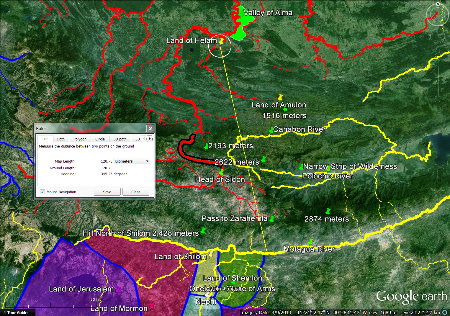
The Narrow (Small) Neck of Land showed why many Book of Mormon students think a) the narrow (small) neck of land, b) Lib's city, c) the east-west Bountiful/Desolation line, d) Hagoth's port and e) the place where the sea divides the land are all clustered near each other along f) the Nephite west coast. We showed plausible correlates on the modern map for all 6 of these geographic referents and demonstrated with satellite imagery how our candidates are a good fit to the text. That is a lot going on in a relatively compact area (the Municipio of Tonala, Chiapas) but there is more. In this post we analyze in-depth the narrow pass mentioned in Alma 50:34, Alma 52:9 and Mormon 3:5-8 as well as the narrow passage referenced in Mormon 2:29. We also look at the fortified defensive line described in Helaman 4:6-8.

      A natural question: Do all 3 references to the "narrow pass" refer to the same topographic feature? Yes. Common textual motifs such as borders of the lands Bountiful & Desolation, movement into the lands northward and southward, fortifications, military activity and proximity to the sea assure us that we are dealing with the same place on the Nephite map.

      A second question: Are the "narrow pass" and the "narrow passage" the same thing? Probably not. The text in Mormon 2:29 lacks most of the motifs mentioned above, so we will assume the narrow pass and narrow passage are two different topographic features.

      A third question: Is the narrow pass near the narrow neck of land? Yes. In point #18 of the article "Narrow and Small Things" we identified three textual motifs common to the passages (Alma 22:32, Alma 63:5 and Ether 10:20) describing the narrow (small) neck of land: a) the narrow or small neck of land was located near the land southward/land northward border which was also the land Bountiful/Desolation border, b) the narrow (small) neck of land was on the seacoast, with 2 of the 3 relevant texts identifying the sea as the west sea, and c) the narrow (small) neck was a travel corridor for people going northward or southward. We find all 3 textual motifs in the passages (Alma 50:34, Alma 52:9, and Mormon 3:5-8) describing the narrow pass: a) the land southward/land northward border which was also the land Bountiful/Desolation border appears prominently in these passages, b) the narrow pass was near the seacoast, with 1 of the relevant texts specifically mentioning the west sea, and c) the narrow pass was in a travel corridor for people going northward or southward. There is also a fourth textual motif that further links the narrow neck and narrow pass together geographically: Alma 22:33 describes Nephite guards and armies who prevented the Lamanites from moving through the narrow neck of land area into the land northward. Denying Lamanite access to the land northward at this particular point was a strategic Nephite military objective. We find the same thing in Alma 50:34-35. Teancum militarily engaged Morianton to prevent the Nephite dissenters from moving into the land northward. In Alma 52:9 Captain Moroni ordered Teancum to militarily fortify and secure the narrow pass area to prevent Lamanite incursions into the land northward. Over 400 years later Mormon did the same thing. Mormon 3:5-6 talks about armies and fortifications attempting to prevent the Lamanites from breaching a Nephite defensive line established by the narrow pass. The conclusion is unmistakable. All 6 texts are describing the same locale using similar words and concepts. The narrow neck of land and the narrow pass are very near each other.

      This means the 15 textual criteria we established for the narrow (small) neck of land (see the blog article "The Narrow (Small) Neck of Land") are directly relevant to the narrow pass as well.           

      Careful exegesis allows us to identify sixteen additional criteria the narrow pass must satisfy, enumerated as 1 - 16 with aqua shading.

      Morianton and his people were moving northward but had not yet reached the land northward Alma 50:33 when they encountered Teancum and his army. Teancum was moving southward, coming to the battle from the Desolation (northward) side of the Bountiful/Desolation line Alma 50:34. Both groups were in a hurry and would have traveled via efficient routes. Teancum had the advantage that he could travel through Nephite controlled areas while Morianton, with the Nephite equivalent of an all points bulletin and a warrant out for his arrest, would have avoided places with a strong Nephite presence. Where did Teancum come from? Alma 50:35 tells us that Teancum had been with Captain Moroni in the fortified city of Moroni. So, Teancum traveled from the extreme south eastern corner of Nephite lands to the west coast and arrived at the east-west Bountiful/Desolation border ahead of Morianton. We should find 2 logical travel routes 1 into the narrow pass. One route should come from the northward (Desolation) side of the Bountiful/Desolation line and the other should come from the southward (Bountiful) side.

      Coming up from the southward, the narrow pass led a) by the sea 2 and b) into the land northward 3Alma 50:34. The next textual phrase has perplexed many Book of Mormon students: "yea, by the sea on the west and on the east"Alma 50:34. Were there 2 seas here? No. Royal Skouson has taught us that "yea clauses" in the Book of Mormon expand on an immediately prior phrase. There was only one sea, the one the narrow pass was adjacent to. But, at this place in Nephite geography, the one sea whose primary direction was west also had an eastern extension. We will find a salt water || dry land || salt water topographic pattern 4 by the narrow pass. It sounds like a coastal sandbar fronting a salt water lagoon.

      Teancum and his troops fought a battle, killed Morianton and repatriated the Nephite dissenters who followed him by the narrow pass in the 24th year of the reign of the judges, ca. 68 B.C. There must be land immediately adjacent to the narrow pass large enough for two armies 5 to engage in battle. We are not told the size of the armies. No adjectives such as "small" or "large" modify the singular noun "army." Based on our analysis of the term "small" in the article "Narrow and Small Things" we estimate an army to have been at minimum 3,000 troops. Our analysis of troop strengths elsewhere in the text (see the article "Population Sizes and Casualty Counts") reinforces this number as reasonable for the size of a militia from a newly-planted land (Morianton) on the Nephite settlement frontier ca. 68 B.C.

      Two years after defeating Morianton by the narrow pass, Teancum received orders from his commanding officer, Captain Moroni, to militarily fortify the land Bountiful and secure the narrow pass Alma 52:9 with a portion of his troops. The remainder of Teancum's forces and Teancum himself remained in the general vicinity of the city Bountiful on the extreme northern edge of the Nephite east coast. The term "fortify" is not a great deal of help. 6 years earlier, Captain Moroni had his troops busily digging up "heaps" and "ridges" of earth around every city throughout "all the land" under Nephite control Alma 50:1. Securing the narrow pass, though, gives us a quantifiable textual requirement to consider. The narrow pass had to be small enough that an army probably not exceeding 5,000 men 6 could prevent movement along it. The narrow pass was clearly a natural choke point in the terrain 7 because Lamanite control of this strategic west coast area would bottle up the Nephites and deny them access to their land northward escape route Alma 52:9. It is important to note that at the precise time Teancum received these orders, the Lamanites already controlled most of the Nephite east coast from Moroni on the south to Mulek on the north.

      Over 400 years later, ca. A.D. 360, Mormon was the supreme commander of Nephite military forces. He gathered much of the Nephite nation together in the area around the city Desolation 8 just north of the east-west Bountiful/Desolation line Mormon 3:5 by the narrow pass. This means the area northward of the narrow pass opens up into an expanse wide enough 9 to accommodate at minimum several hundred thousand people. This also means the area just north of the narrow pass had a high carrying capacity 10. In other words, enough food could be produced in this area to feed the large Nephite population gathered there.

      We saw in Alma 50:34 and Alma 52:9 that when coming from the southward, the narrow pass led into the land northward. From Mormon's perspective already in the land northward, the narrow pass led into the land southward Mormon 3:5. This means a portion of the narrow pass was northward of the east-west Bountiful/Desolation line and another portion was southward 11.

      Mormon caused the Nephites to fortify their lands around the city Desolation against Lamanite invasion "with all our force"Mormon 3:6. Mormon knew this was the Nephite's last real chance to hold sizable contiguous territory for a substantial period of time. The fortifications he directed were extraordinary 12. Captain Moroni, one of Mormon's heroes (see Alma 48:17), directed extensive fortification efforts using earth and stone Alma 48:8 throughout the entire Nephite nation which ranged from the sea east to the sea west. Mormon's fortifications were more intensive in a limited area. Early in his career, Mormon had directed the fortifications around Angola that ultimately proved ineffective Mormon 2:4. Late in his career, Mormon's military engineering was so effective that not only did the Nephites win two decisive battles around the city of Desolation Mormon 3:7-8, they could have remained in and around their fortified city indefinitely Mormon 4:4 had they not arrogantly gone on the offensive and mounted a disastrous invasion of Lamanite lands which decimated their ranks.

      The Lamanites came down to the city of Desolation to battle their ancient foes Mormon 3:7. This means the city of Desolation was lower in elevation 13 than the Lamanite homelands. The city of Desolation was on the seacoast 14 because after a battle large numbers of Lamanite dead were cast into the sea Mormon 3:8.

      The narrow pass crossed the Bountiful/Desolation border which was also the land southward/land northward border. "Bountiful" was a political entity in Nephite times, but the name also had ecological connotations. See the article "Bountiful Context" in this blog. We should find observable differences 15 between the lands Bountiful and Desolation that justify the ecological implications of the term "Bountiful."

      The narrow pass must be narrow 16. Anything over 5 kilometers wide would be inconsistent with Nephite usage of the term "narrow" as we found in the article "Narrow and Small Things."

      Our candidate for the narrow pass is the route the Isthmian Railroad follows today as it winds around the southern flank of Cerro Bernal and the northern shore of Laguna de la Joya. This map shows our narrow  pass in green in its Mesoamerican context. The Mezcalapa-Grijalva River in blue is shown as it flowed in early Nephite times (See the blog article "Wandering River").
      Proposed Narrow Pass in Green on the Pacific Coast of Chiapas
      This map shows a closeup of the narrow coastal plain between the mountains and the sea. The magenta line represents the modern railroad, with the section we are designating the narrow pass in green.
      Isthmian Railroad in Magenta, Proposed Narrow Pass in Green
      And this map shows the narrow pass in context with the other six geographic features (narrow (small) neck of land, Bountiful/Desolation line, city of Lib, Hagoth's port, place where the sea divides the land, and sea west) we discussed in the prior article "The Narrow (Small) Neck of Land." The white line is the continental divide running along the ridge line of the Sierra Madre Mountains. The blue line is a tributary of the Mezcalapa-Grijalva river, and the yellow lines are small rivers emptying into the Pacific Ocean. As before, the magenta line shows the route of the Trans Isthmian Railroad with the section we call the narrow pass shown in green.
      Proposed Narrow Pass, Narrow Neck and Nearby Features
      Let's see how our proposed narrow pass fits the sixteen textual requirements outlined above.

      1. A number of minor trails are known from the Central Depression of Chiapas over the Sierra Madre down to the Chiapas coast, but there are two major routes that people used anciently and still use today. See Carlos Navarrete, "The Prehispanic System of Communications Between Chiapas and Tabasco" in Thomas A. Lee, Jr. and Carlos Navarrete, Mesoamerican Communication Routes and Cultural Contacts, Papers of the New World Archaeological Foundation Number 40, Provo:  BYU NWAF, 1978. This map shows modern Mexican highways in yellow. The northward route into the Tonala area comes from Cintalapa or Villa Corzo through a natural pass in the Sierra Madre Mountains (highlighted as a green circle) and into Arriaga before coming southward into Tonala. The magenta line represents the Trans Isthmian Railroad.
      Northward Pass Through the Sierra Madre Mountains into Arriaga
      The southward route into Tonala goes from Motozintla over a natural pass in the Sierra Madre Mountains (highlighted as a green circle) into Huixtla, and from there along the coastal route northward into Mapastepec and beyond.
      Southward Pass Through the Sierra Madrea Mountains into Huixtla
      This map shows the Narrow Pass area with the two major routes over the Sierra Madre Mountains highlighted as green circles.
      Northward and Southward Routes into the Tonala Area
      We do find 2 logical travel routes into our proposed narrow pass, one coming in from the northward (Desolation) side and the other from the southward (Bountiful) side. Criterion 1 satisfied.

      2, 3. Coming from the southward, our proposed narrow pass is 3.5 kilometers across the Barra San Marcos [our narrow (small) neck of land] from the open Pacific Ocean.
      Proposed Narrow Pass by the Sea
      It certainly does lead by the sea into the land northward (across the red Bountiful/Desolation line). Criteria 2 & 3 satisfied.

      4. Now things get really interesting. At this precise point along the Chiapas coast, the topography deftly matches Mormon's description of a narrow pass by the sea on the west and also on the east. The Pacific Ocean is the sea on the west. The salt water Laguna de la Joya is a credible eastward extension of the west sea. On this map, we call it "Sea West East" which means that part of the sea west that lies east of the narrow neck of land.
      Proposed Narrow Pass Leading by the
      Sea on the West and on the East
      Our narrow pass clearly goes by the sea west, the Pacific Ocean, and then by the eastward extension of the sea west, the Laguna de la Joya. Criterion 4 satisfied.

      5. Just south of the Bountiful/Desolation line, there is an area west of our narrow pass large enough to have been the battlefield where Teancum slew Morianton. It is highlighted as a red-shaded polygon in the map below.
      Proposed Teancum Morianton Battlefield
      The red-shaded polygon covers 46 square kilometers, much more than enough territory for a battlefield accommodating 6,000 to 10,000 combatants. Criterion 5 satisfied. As a point of comparison, the 2010 Mexican census from INEGI reported the modern city of Tonala, shown on the map above, with a population of 35,322.

      6. To determine the defensibility of our proposed narrow pass, we selected 8 points along it and set a .5 kilometer transect perpendicular to it at each point. Transects begin at the water's edge and run up the slope of Cerro Bernal. In one case, the transect is 1 kilometer in length because the Trans Isthmian Railroad is already .5 kilometer from the coastline. This map shows the 8 transects in white.
      8 Transects Perpendicular to our Proposed Narrow Pass
      Google Earth has a feature called "Elevation Profile" that graphs the elevation along a line. This is the elevation profile for Narrow Pass Transect #7. It shows a steep rise from near sea level to over 100 meters in elevation across the .5 kilometer length of the transect.
      Elevation Profile, Narrow Pass Transect 7
      We see very similar results on all 8 transects. Moving from southward to northward, maximum transect elevations are 109 meters, 127 meters, 171 meters, 87 meters, 127 meters, 50 meters (on the 1 kilometer long transect), 107 meters, and 111 meters. We chose transect lengths of .5 kilometers (500 meters) because history shows that is a reasonable length for a defensive line protected by a small army of a few hundred men. At each of our 8 sample points, attackers would have had a very small coastal plain to maneuver before encountering the steep, heavily forested slopes of Cerro Bernal where defenders would have held a significant uphill advantage.

      The narrow coastal plain around Cerro Bernal is clearly a place where a Nephite army of fewer than 5,000 troops could have prevented large scale northward movement. Criterion 6 satisfied.

      7. To show the dramatic terrain around our proposed narrow pass, we turn on shaded relief, resulting in this map.
      Proposed Narrow Pass Area in Shaded Relief
      Cerro Bernal is a spur of the Sierra Madre nearly 1,000 meters in elevation. It is the place along the entire Chiapas coast where the mountains come closest to the sea. This creates a natural choke point in the topography where movement northward or southward is channeled in three narrow travel corridors. The Trans Isthmian Railroad, a portion of which we have designated the narrow pass, follows the middle of these corridors. Criterion 7 satisfied.

      8, 9. The following map shows our concept of the land Bountiful in green overlay and the land Desolation in brown overlay with the east west Bountiful/Desolation line in red between them.
      Proposed City of Desolation Area North of the
      East West Bountiful/Desolation Line 
      Two things are readily apparent on the map above. 1) A poorly studied ancient site known to archaeologists as Paredon lies on the coast of Mar Muerto just north of our Bountiful/Desolation line. Paredon could have been the city of Desolation. The surveyed ruins are engulfed by the modern city of Paredon which had a population of 6,126 in the 2010 Mexican Census. So, we find a candidate for the city of Desolation in the precise place where our model predicted it should be. 2) The coastal plain which is less than 1 kilometer wide along most of our narrow pass broadens out to 12 kilometers between the cities of Paredon and Tonala as the yellow ruler on the map above indicates. Assuming that the greater city of Desolation area where Mormon concentrated the Nephites ran from our east west Bountiful/Desolation line to the Tiltepec River and was bounded on the west by the Mar Muerto and on the east by our proposed border of the land Desolation, the area would have looked like the yellow-shaded polygon on the map below.
      Proposed Greater City of Desolation in Yellow
      The area in yellow is 278 square kilometers. As a point of comparison, Washington D.C. has a surface area of 177 square kilometers. Is this Tonala, Chiapas area large enough to have been the Nephite capital from ca. A.D. 360 to ca. A.D. 363? Yes. 278 square kilometers should have been adequate space for the events being described in Mormon chapters 3 & 4. Criteria 8 & 9 satisfied.

      10. The Mexican government uses the 2,348 municipios in the country as primary units for statistical reporting and analysis. The municipio of Tonala is shown in the map below.
      Municipio of Tonala, Chiapas, Mexico
      Among the 122 municipios in the state of Chiapas, Tonala is the leading producer of fish and shrimp. The large Mar Muerto is one of the most productive fisheries in all of Mexico, and the city of Paredon is the leading fishing port on the Mar Muerto coast. Tonala also exports large quantities of beef. It is the third most important cattle ranching area in Chiapas. Other important agricultural exports include corn and mangoes. See production statistics published by SAGARPA, Secretaria de Agricultura, Ganaderia, Desarrollo Rural, Pesca y Alimentacion. As a large net exporter of foodstuffs, the Tonala area has a high carrying capacity. Criterion 10 satisfied.

      11. As the map below shows, the Cerro Bernal mountain spur extends north westerly beyond our Bountiful/Desolation line shown in red. This means our narrow pass, shown in green, crosses over the land southward/land northward border and can properly be described as leading into the land southward when one is coming from a northward direction, or leading into the land northward when one is coming from a southward direction.
      Proposed Narrow Pass Northward and Southward
      of the Bountiful/Desolation Line
      Criterion 11 satisfied.

      12. If we have sited the city and land Desolation in the right place, we should find evidence of unusually effective fortifications in use anciently, and we do. The area around Tonala has archaeological sites described as "megalithic" or in other words, built of very large stone blocks. And the type of stone being used? Granite with a hardness of 6 on the mohs scale. The Tonala area is unique in all Mesoamerica in its use of megalithic architectural granite. Some of the granite blocks are 3 meters long and weigh more than a ton. This is a geologic surface map of Mexico published in 1992 by the Instituto de Geologia de la UNAM showing where the granite came from.
      Granite Outcroppings in the Tonala, Chiapas Area
      The red oval on the map above highlights the location of the kind of granite used anciently as building material. The stone came from the Cerro Bernal and a small area immediately north of the modern city of Tonala. This particular type of architectural grade granite is quite rare in Mexico, but abundant in the precise location we have identified as the narrow neck of land - narrow pass area.

      In 2007, INAH began a major excavation project at the large site of Iglesia Vieja 4 kilometers north of the city of Tonala. The lead investigator is Akira Kaneko. An accessible early field report is Akira Kaneko, "Investigacion Arqueologica en la Region Tonala de la Costa del Pacifico de Chiapas" in J. P. Laporte, B. Arroyo and H. Mejia, XXII Simposio de Investigaciones Arqueologicas en Guatemala, 2008, Guatemala City: Museo Nacional de Arqueologia y Etnologia, 2009. Some items of interest to Book of Mormon students from the Kaneko report:
      • Tzutzuculi was an Olmec site that flourished from ca. 1,000 B.C. to ca. 400 B.C.Originally it had more than 14 major mounds. 11 large sculptures have been discovered to date, including a stone head .91 meters high. No megalithic architecture is known from this site.
      • Tiltepec was an Olmec site that flourished from the middle preclassic to the late preclassic, ca. 950 B.C. to ca. 400 B.C. More than 60 mounds have been reported, as well as 36 sculpted monuments carved from granite.
      • La Perseverancia was a large site that flourished from ca. 400 B.C. to ca. A.D. 200. It is similar in many ways to Izapa and Takalik Abaj, but without any known stone sculpture. This site used large granite blocks for structural cornerstones and stairways.
      • Iglesia Vieja consists of 80 structures in 5 architectural groups covering 60 hectares. Structures are built on natural hills. Some structures are surrounded by walls. Megalithic granite is used throughout. The large blocks are joined without mortar. Radio carbon dates from this site range from A.D. 242 to A.D. 385.
      • The site of Ciudad Perdida on Cerro Bernal had close ties with Iglesia Vieja. It was also built with metalithic granite throughout. It is located strategically on the narrowest part of the Chiapas coast to control movement along the coastal travel route.
      • The site of Los Horcones sits beside Cerro Bernal. It had more than 100 structures oriented north - south. 4 stelae, carved from granite, are known. Most archaeologists believe Los Horcones was a trading center and one of its main functions was to control the travel route between Teotihuacan (near Mexico City) and Kaminaljuyu (Guatemala City).
      • Over 20 ancient sites are known in the Tonala area. The earliest sites were located by rivers in the typical Olmec and Mesoamerican pattern. Later sites from the late preclassic and early classic (ca. A.D. 200 to A.D. 400) were built atop natural hills to maximize defensive potential. The later sites also made more extensive use of megalithic granite. Many sites are clearly located to control transit routes along the Chiapas coast. This part of the Chiapas coast was strategically located on a natural transportation corridor. 
      • The human effort required to construct large sites with heavy granite blocks was enormous. This area is blessed with a natural environment that provided enough food to sustain large populations, freeing up labor for massive public works.
      This map shows the 4 sites studied to date that were built with megalithic granite architecture.
      4 Ancient Megalithic Granite Architecture Sites
      And this map shows 13 of the 20+ archaeological sites currently known to science in the Municipio of Tonala, Chiapas.
      13 Known Archaeological Sites in and around Tonala
      So, unique in all Mesoamerica, we do find extraordinary defensive fortifications made of granite sitting atop natural hills in the precise area where we have sited the narrow neck of land and the narrow pass. Criterion 12 satisfied.

      Megalithic architecture has been reported at a number of Maya sites. This map shows Kaneko's list of known sites built with very large stone blocks.
      Megalithic Architecture in Mesoamerica
      The Maya sites all used some form of limestone which averages a hardness of 3 on the mohs scale. The granite used in the Tonala sites was orders of magnitude more difficult to work, but also much more effective as a defensive building material.

      13. Our candidate for the city of Desolation, Paredon, is essentially at sea level on the coast of the large Mar Muerto. Practically anywhere the Lamanites would have come from would have been up in elevation relative to Paredon.
      Paredon, Chiapas Surrounded by the Sierra Madre Mountains
      This topography precisely fits the text. The Lamanites would have come down to battle the Nephites in their city Desolation by the sea. Criterion 13 satisfied.

      14. Zooming in on our candidate city of Desolation, Paredon, we see that it is indeed on the seacoast of the large Mar Muerto lagoon that opens to the Pacific Ocean. 
      The Ancient Site of Paredon by the Sea
      Criterion 14 satisfied.

      15. Our proposed boundary between the lands of Bountiful and Desolation is very near the political border between the modern Mexican states of Chiapas to the southward and Oaxaca to the northward. The east west Bountiful/Desolation line is shown in red on the map below.
      Bountiful/Desolation Line near the  Chiapas/Oaxaca Border 
      Part of the meaning of "Desolation" in Nephite parlance was cultural, derived from the presence of Jaredite ruins in the land Alma 22:30. This is a map of known Olmec and Olmec-influenced sites northward from our Bountiful/Desolation line in red.
      Bountiful/Desolation Line Relative to the Olmec Heartland
      The orange line surrounds Olmec heartland sites in southern Veracruz and western Tabasco. The magenta line represents the Trans Isthmian Railroad that follows the ancient communication route between the Chiapas coast and the Gulf of Mexico. The yellow line is our representation of the route Mulek and his colony took landing first in the Papaloapan River Basin, coasting by the Coatzacoalcos and Mezcalapa-Grijalva River Basins and finally settling in the Usumacinta River Basin. Northward from our Bountiful/Desolation line in red, the ancient route to the Veracruz coast passed by the Olmec sites Tzutzuculi, Tiltepec, Laguna Zope, and Tepalcate before crossing the center of the Isthmus of Tehuantepec and entering the Olmec heartland via the site of Las Limas. This direct connection between the Tzutzuculi/Tiltepec area and the Olmec heartland supports our use of the term "Desolation" near Tonala.

      Another part of the meaning of "Desolation" in Nephite usage was ecological. Desolation had far fewer trees than Bountiful Helaman 3:6-7Helaman 3:9. This map based on satellite imagery from NASA shows land cover with denser vegetation darker shades of green.
      NASA Land Cover Classification 
      The red line is our east west Bountiful/Desolation line referenced in Alma 22:32. The yellow line is our proposed boundary between the entire lands of Bountiful and Desolation. It is clear that vegetation is much denser on the Bountiful side of the border.

      Satellite imagery also has the ability to map forest canopy heights. In this map from NASA, darker green means taller trees.
      NASA Forest Canopy Heights
      It is obvious that there are more trees and taller trees on the Bountiful side of the border.

      This image is from NASA's famed Blue Marble series. It shows our area of interest in the dry season.
      NASA Blue Marble Image - Dry Season
      Clearly, the earth is much greener on the Bountiful side of the border.

      This map from INEGI shows areas of dense vegetation.
      Areas of Dense Vegetation per INEGI
      Desolation has fewer areas of dense vegetation than Bountiful.

      This is a map from INEGI showing average annual precipitation. We are only showing isobars for those areas that receive more than 1,500 millimeters of precipitation each year.
      Areas Receiving more than 1,500 Millimeters
      of Average Annual Precipitation per INEGI
      In the southern part of the Isthmus of Tehuantepec, our Bountiful/Desolation border is a pretty stark line. All points immediately on the Bountiful side of the boundary receive at least 1,500 millimeters of precipitation annually. Almost all points immediately on the Desolation side of the border are drier.

      Rainfall is reflected in stream flow. This map shows rivers and streams emptying into the Pacific in yellow. Tributaries of the Mezcalapa-Grijalva are show in blue. Our east west Bountiful/Desolation line is in red, and our proposed boundary between the entire lands of Bountiful and Desolation is in brown.
      Streams Emptying into the Pacific
      As you move northward across the east west Bountiful/Desolation line and travel across our land Desolation,  the streams become fewer and further between.

      The Bountiful/Desolation line which is also the land southward/land northward line clearly separates areas that differ politically, culturally (in antiquity) and ecologically. In general, the area we have called "Bountiful" has denser vegetation, more and taller trees, higher rainfall and more flowing streams than the area we have called "Desolation." There is ample justification for the ecological implications of our use of the term "Bountiful." Criterion 15 satisfied.

      16. Our proposed narrow pass truly is narrow according to the Nephite sense of that term. Here is a closeup of our narrow pass skirting around the south western edge of Cerro Bernal.
      Proposed Narrow Pass around Cerro Bernal
      At the point indicated by the yellow ruler in the image above, the coastal plain flanking Cerro Bernal is .29 kilometers wide. This is narrow enough to fit the definition we have established based on Nephite usage of the term. Criterion 16 satisfied.

      Our candidate for the narrow pass, the route of the Trans Isthmian Railroad around Cerro Bernal and Laguna de la Joya, is a decidedly good fit to the text. It comfortably meets all 16 criteria we developed through careful reading.

      A single verse, Mormon 2:29, refers to a geographic feature called the narrow  passage which led into the land southward. The context was ca. A.D. 350 when the Nephites negotiated a treaty with the Lamanites and Gadianton Robbers. The Nephites got the entire land northward, their enemies the entire land southward. There are 3 reasons we believe the narrow passage was in the same locality as the narrow (small) neck of land and the narrow pass:
      • The language Mormon used to describe the narrow passage (which led into the land southward) is identical to his description of both the narrow (small) neck of land (which led into the land northward) Alma 63:5 and the narrow pass (which led into the land southward) Mormon 3:5.
      • The narrow passage was clearly at the border between the lands northward and southward. All other references in the text to this border can be shown in context to refer to the area near the narrow (small) neck of land and the narrow pass.
      • Events in the text after A.D. 350 (Mormon 3:5) show that the Nephites were in the area near the narrow (small) neck of land and the narrow pass.
      This means there were 3 different land routes to move between the lands northward and southward:
      • via the narrow (small) neck of land
      • via the narrow pass
      • via the narrow passage
      Our candidate for the narrow passage is the route followed by Mexican Federal Highway 200 as it passes between Cerro Bernal and the Sierra Madre Mountains. This  map shows our proposal as an aqua colored line.
      Proposed Narrow Passage in Aqua
      This map shows the 3 different land routes to move between the lands northward and southward. The narrow (small) neck of land route is shown in purple, the narrow pass route in green, and the narrow passage route in aqua.
      3 Routes Across the Bountiful/Desolation Line
      The known archaeological sites in the Municipio of Tonala, Chiapas correlate remarkably well with the 3 land routes we have identified. Cabeza de Toro and Las Animas are on Barra San Marcos which we correlate with the narrow (small) neck of land. Estacion Mojarras guards our narrow pass. And, Ocuilapa, La Polca and Los Horcones all straddle our proposed narrow passage. Fraccion Mujular and Ciudad Perdida overlook our narrow passage from the heights of Cerro Bernal, while Perseverancia is just down the road following the same trajectory. So, the locations of the ancient sites in the area support our 3 proposed travel routes through the constricted Cerro Bernal area.
      Ancient Sites Correlated with our 3 Routes
      across the Bountiful/Desolation Line
      One final question: Is the proposed narrow passage truly narrow? This is a closeup of the area around the site of Los Horcones.
      Proposed Narrow Passage near the Site of Los Horcones
      As the yellow ruler on the map above indicates, our narrow passage at this point measures 1.77 kilometers from mountain to mountain. Our analysis (see the article "Narrow and Small Things") suggests that a topographic feature less than 5 kilometers wide could reasonably be considered "narrow" according to Nephite usage. Our narrow passage candidate easily qualifies. An archaeologist who recently worked in this area, Claudia Garcia-Des Lauriers, called the passage a "narrow natural corridor" Claudia Garcia-Des Lauriers, "The Early Classic Obsidian Trade at Los Horcones, Chiapas, Mexico,"FAMSI: 2008. 

      One final feature will complete our map of the narrow (small) neck of land, narrow pass area. Helaman 4:7 describes a fortified east west defensive line that lay entirely within the land of Bountiful on the west coast. It had the familiar trappings of military defenders trying to keep the Lamanites from invading the land northward. Our candidate for this fortified line is shown in red on the map below, beginning at the modern town of La Polka on the shores of Laguna de la Joya, passing through the site of Los Horcones, and terminating at an elevation of of 514 meters in the Sierra Madre.
      Proposed East West Bountiful Defensive Line with Ruler
      These are the 3 textual requirements for this fortified line (in aqua) we have gleaned from our reading:
      1. There was a land near the land Bountiful southward from Bountiful Helaman 4:5.
      2. The defensive line began at the west sea and terminated at an unspecified location to the east Helaman 4:7.
      3.The line was approximately 15 straight line kilometers long based on the standard Nephite unit of measure "a day's journey" discussed in the article "Land Southward Travel Times."

      1. In the map above, the land Desolation is represented with a brown overlay. The land Bountiful is represented with a green overlay. The land which was near the land Bountiful is represented with a blue overlay. The land of Joshua mentioned in Mormon 2:6 may be a later appellation for this same land. There is a plausible space southward from our land Bountiful that could have been the land which was near the land Bountiful. Criterion 1 satisfied.

      2. In the map above, the east west Bountiful defensive line begins at the salt water Laguna de la Joya which is an eastward extension of the Pacific Ocean. It runs east, up the slopes of the Sierra Madre Mountains. This feature is very similar to the east west Bountiful/Desolation line that figures so prominently in our discussion of the narrow (small) neck of land, narrow pass area. Our Bountiful/Desolation line begins at the Mar Muerto and terminates at an elevation of 525 meters. Our Bountiful defensive line begins at the Laguna de la Joya and terminates at an elevation of 514 meters. Criterion 2 satisfied.

      3. The ruler placed on the map above shows the length of our Bountiful defensive line as 15 straight line (air) kilometers. Criterion 3 satisfied.

      Have any ancient fortifications been discovered along our proposed Bountiful defensive line? F. Richard (Ric) Hauck has reported fortification walls at the site of Los Horcones (Joe V. Andersen, personal communication). The megalithic architecture at the site of Ciudad Perdida was defensive in nature. This poorly studied hilltop fort overlooked the natural travel corridor we have identified as the Book of Mormon's narrow passage. See Akira Kaneko, "Investigacion Arqueologica en la Region Tonala de la Costa del Pacifico de Chiapas" in J. P. Laporte, B. Arroyo and H. Mejia, XXII Simposio de Investigaciones Arqueologicas en Guatemala, 2008, Guatemala City: Museo Nacional de Arqueologia y Etnologia, 2009.

      So, our proposed east west Bountiful defensive line is a good fit to the text with 3 of 3 criteria correlating well.

      We end up with a map that includes these 15 features from Nephite geography:
      • Bountiful defensive line (1 day's journey) Helaman 4:7 (red line running east from the modern town of La Polka on the shores of Laguna de la Joya)
      • Bountiful/Desolation line (1.5 day's journey) Alma 22:32, 3 Nephi 3:23 (red line running east from a point south of the modern city of Paredon on the shores of Mar Muerto) 
      • city of Desolation Mormon 3:5-7 (ancient site of Paredon)
      • city of Lib Ether 10:19-20 (ancient site of Tzutzuculi)
      • Hagoth's port Alma 63:5 (Mar Muerto coast south of the modern city of Paredon)
      • land Bountiful Alma 63:5 (green overlay, political but also ecological entity)
      • land Desolation Alma 63:5 (brown overlay, political entity with ancient cultural, ecological implications)
      • land which was near the land Bountiful Helaman 4:5 (blue overlay)
      • narrow (small) neck of land Alma 22:32, Alma 63:5, Ether 10:20 (purple path runs through it into the land northward)
      • narrow pass Alma 50:34, Alma 52:9, Mormon 3:5 (green path following Trans Isthmian Railroad)
      • narrow passage Mormon 2:29 (aqua path following Mexican National Highway 200)
      • place where the sea divides the land Ether 10:19-20 (outlet of Mar Muerto to the Pacific)
      • sea on the west and on the east Alma 50:34 (Pacific Ocean & Laguna de la Joya)
      • Teancum - Morianton battlefield Alma 50:34-35 (coastal plain between Mar Muerto & Laguna de la Joya)
      • west sea Alma 63:5 (Pacific Ocean)
      As with all images on this blog, click to enlarge.
        15 Proposed Nephite Geographic Features near Tonala, Chiapas

        The Narrow Strip of Wilderness

        $
        0
        0
        The Book of Mormon makes a single reference to the narrow strip of wilderness Alma 22:27 but this natural feature on the Nephite/Lamanite landscape looms large in any attempt to correlate the text with the modern map. Actually, there are other references to the narrow strip of wilderness, but under different names. For example:
        • Alma 22:29 calls it the wilderness at the head of the river Sidon
        • Alma 27:14 calls it the wilderness which divided the land of Nephi from the land of Zarahemla
        • Alma 50:11 calls it the line between the Nephites and the Lamanites, as well as (the line) between the land of Zarahemla and the land of Nephi
        • Alma 50:13 calls it the line of the possessions of the Lamanites
        Detailed exegesis of these texts yields 32 criteria that will help us identify the narrow strip of wilderness on modern maps. These requirements are enumerated 1 - 32 below in aqua.
          The narrow strip of wilderness was the northern boundary 1 of the greater land of Nephi. This land of Nephi border was relatively straight 2, particularly along its eastern section Alma 50:8. The land of Nephi was continental in scope, running from the east sea Alma 50:8 to the west sea 3 Alma 50:11 which is precisely the sense of  Alma 22:27 when it says that the land of Nephi ran even to the sea on the east and on the west. The narrow strip of wilderness itself was oriented east west 4 and ran from the sea east even to the sea west 5Alma 22:27. North of the narrow strip of wilderness lay the greater land of Zarahemla. Early in its history (ca. 90 B.C.), this greater Zarahemla was confined to the central Sidon corridor and environs and did not yet reach the east sea 6. The east coast was filled with Lamanites Alma 22:29 who had been driven eastward by the expansion of Nephite settlements moving their direction See the blog article "Expansion of the Nephite Nation." The Nephites finally reached the east sea ca. 72 B.C. when they founded the city of Moroni Alma 50:13.

          Note 1. In terms of geographic content, Alma 22 and Alma 50 are parallel texts describing the Nephite geo-political situation from Mormon's point of view in 2 axial periods: ca. 90 B.C. (when the 4 sons of Mosiah were beginning their missionary labors among the Lamanites at the beginning of the reign of the judges) and ca. 72 B.C. (when Captain Moroni was expanding the size of the Nephite nation toward its territorial maximum just before the Nephite golden age Alma 50:23) respectively.

          In the earlier period (ca. 90 B.C.) the greater land of Zarahemla did not yet extend to the west coast either. Lamanites lived on the coast west of Zarahemla Alma 22:28. Emboldened by Captain Moroni's strategic innovation, fortified cities, the Nephites only began a westward push ca. 72 B.C. Alma 50:11 and by ca. 66 B.C. we see the first mention in the text Alma 52:11 of Nephite settlement along the west coast of greater Zarahemla. Nephites had earlier established a defensive outpost at a strategic location along the west coast, but it was in the  land Bountiful Alma 22:33 just southward from the land Desolation. See the final map in the article "The Narrow Pass and Narrow Passage" for our correlation of the east west Bountiful/Desolation line in context with 14 other Nephite geographic features clustered near each other in the Municipio of Tonala, Chiapas. So, it is clear why Mormon said the Nephites, ca. 90 B.C., were nearly surrounded by Lamanites Alma 22:29. They had Lamanites on the east coast, the west coast, and south of the narrow strip of wilderness. Eventually the Nephite domain, like the Lamanites before them, extended from sea to sea 7 Helaman 11:20.

          The narrow strip of wilderness had some circularity to it near the west coast 8Alma 22:27. This is the sense of the phrase "round about on the borders of the seashore." Additional wilderness lay north of the  narrow strip of wilderness and south of the then (ca. 90 B.C.) inhabited portions of the greater land of Zarahemla 9Alma 22:27. Keep in mind that ca. 90 B.C. the Nephites had begun settling eastward from the central Sidon corridor but had not yet established settlements in their west. See the articles "Ammonihah Noah & Sidom all East of Sidon" and "Sidon East then West." Continuing further west, the narrow strip of wilderness passed by the southern border of the land of Manti 10 and then passed by the head of the river Sidon 11 Alma 22:27.

          Note 2. It order to understand Mormon's thought process in Alma 22:27 it is important to keep in mind that he passes three times from east to west. The first pass describes the land belonging to the King of the Lamanites which stretched from the sea on the east to the (sea) on the west. The second pass describes the narrow strip of wilderness boundary that separated the greater land of Zarahemla on the north from the greater land of Nephi on the south. The narrow strip of wilderness also ran from the sea east even to the sea west with some circular (round about) irregularity near the west coast. The third pass follows the narrow strip of wilderness again (running from the east towards the west), filling in some details (of only the eastern half) along the way. As you move west along the narrow strip of wilderness, you come first to wilderness south of the greater land of Zarahemla, second to the southern boundary of the land of Manti (which was east of Sidon - see the blog article entitled "Manti"), and third to the head of Sidon. The Sidon ran generally from south to north 12 (See the article "Sidon South to North") through the center 13 Helaman 1:24-27 or heart Helaman 1:18 of Nephite lands. In the parallel passage Alma 50:11, Mormon indicates a Nephite geo-political shift through a textual shift. The geo-political shift was that the Nephites had fulfilled their manifest destiny in the east and their strategic focus was now on the west and beyond into the land northward. The textual shift is that every reference prior to Alma 50:11 mentions the east before the west (As Alma 22:27 does 3 times). Alma 50:11 starts out in the east (east wilderness) and then mentions that the Nephite military under Captain Moroni forcibly ejected the Lamanaites from Nephite lands in the west. From that point on in the Book of Mormon, all east west couplets mention the west before the east. Mormon describes the narrow strip of wilderness line beginning at the west sea and running eastward by the head of the river Sidon. And what do we find in that western half of the narrow strip of wilderness boundary? Nephite control north of the line (after ca. 72 B.C.), the land Bountiful (by the west sea) 14 Alma 63:5 and the land northward beyond Bountiful 15 Alma 22:33..

          The head of the river Sidon deserves some analysis of its own. The relevant scriptural passages are Alma 22:27, Alma 22:29, Alma 43:22, Alma 50:11, and Alma 56:25. The foregoing has shown that the head of Sidon was on the extreme southern boundary of Nephite territory 16 a considerable distance inland from both the east sea 17 [starting at the east sea, you come to wilderness (The Nephites had not yet settled Moroni nor Nephihah ca. 90 B.C.) and then the land of Manti before you get to the head of Sidon Alma 22:27] and the west sea 18 [we learn from Helaman's epistle to Captain Moroni that Judea (near the west coast), Antiparah, Cumeni and Zeezrom Alma 56:14-15 all lay west of the head of Sidon which was immediately south of Manti]. This confirms that the upstream head of Sidon and the downstream local land of Zarahemla were both roughly in the center of Nephite lands. There was a logical route 19 for the Lamanites under Zerahemnah to travel from the land of Antionum near Jershon (near the east sea Alma 27:22, Alma 31:3) in a south westerly arc through the wilderness [see the article "A Note About Wilderness" for perspective - wilderness meant absence of Nephite (or Lamanite as the case may be) political control, not absence of human beings] and then passing by the head of Sidon before attempting an unsuccessful invasion of Manti Alma 43:22. This wilderness south and west of Antionum (ca. 74 B.C.) is probably the same wilderness Mormon was describing in Alma 22:27 that lay east of Manti and north of the narrow strip of wilderness (ca. 90 B.C.). This was clearly part of the big east wilderness (east relative to the local land of Zarahemla and the central Sidon corridor) that Captain Moroni cleared Alma 50:11 before founding Moroni Alma 50:13 and Nephihah Alma 50:14 ca. 72 B.C. By coming into the land of Manti from the south near the head of Sidon, rather than a more direct route simply entering from the east, the Lamanites under Zerahemnah hoped to achieve an element of surprise 20 Alma 43:22. Coming in from a generally north easterly direction, it was possible to pass by the head of Sidon without crossing over it 21 Alma 43:22. One could then cross Sidon itself from east to west further downstream 22 Alma 43:35. Coming from the west one would cross over 23 the head of Sidon en route to Nephihah Alma 56:25. A persistent thread of Book of Mormon geographical exegesis interprets the phrase "running from the east towards the west" in Alma 22:27 to mean that the river Sidon itself flowed in a westerly direction at this point in its course. I (Kirk Magleby) do not read the text that way. I believe Mormon was referring to the narrow strip of wilderness rather than the river. Nevertheless, in deference to this alternate viewpoint, we will consider that the river Sidon may have flowed from east to west 24 in the immediate vicinity of the head of Sidon before turning generally northward past the local lands of Manti, Melek, Minon, Zarahemla and Gideon.

          What is the head of a river? 1 Nephi 8:17 is not a great deal of help. The head of a river is clearly upstream from one's point of view along the main channel. Is it the headwaters like Lake Itasca spawning the Mississippi? the tributary furthest from the mouth like Mount Mismi in Arequipa Province, Peru 6,800 kilometers from the Amazon's mouth in the Atlantic? Not necessarily. Genesis 2:10 (repeated in Moses 3:10 and Abraham 5:10) describes the head of a river as the origin point of distributaries, each of whom is a river in its own right. Consulting the Oxford English Dictionary, we find that the head of a river can be a) the point at which a stream either enters or exits a lake, b) the highland source of a stream, or c) the confluence point where two tributaries join to form a new river. The area around Three Rivers Stadium in Pittsburgh, for example, is often referred to as the head of the Ohio because the Allegheny coming in from the north joins the Monongahela coming in from the south at that point. So, the geographic feature we call the head of the river Sidon must meet one of these commonly accepted definitions 25 for a "head" of a river.

          Turning our attention again to the narrow strip of wilderness boundary, the area was large enough to accommodate the people of Ammon (Anti Nephi Lehies) 26 while they waited word from the Nephites about a new homeland Alma 27:14-15. On the other hand, it was small enough to justify the adjective "narrow"27 (See the article "Narrow and Small Things"). The dictionary definition of a "strip" is something much longer than it is wide. The most famous strip of land in U.S. History was the Cherokee Strip (not to be confused with the much wider Cherokee Outlet). It had a 3.96 kilometer wide section in the modern state of Kansas and a 3.2 kilometer wide section in what is now Oklahoma between the 96th and 100th meridians of longitude. The Cherokee strip was approximately 362 kilometers long and 7 kilometers wide. So, our narrow strip of wilderness should conform to commonly held notions of what constitutes a "strip" of land 28.
          From a continental perspective, the narrow strip of wilderness was small enough to be considered a "line"29 Alma 50:11, Alma 50 13.

          The narrow strip of wilderness had properties that made it a natural line of defense 30 for the Nephites who placed fortifications at key points along its northern edge Alma 50:10-11.

          The narrow strip of wilderness was the principal boundary between the Nephites and Lamanites Alma 22:27, Alma 50:11, groups who differed politically, ethnically and religiously, but who shared a very similar material culture. We would expect to find evidence of this littoral function 31 along our boundary line in the archaeological literature.

          The narrow strip of wilderness should exhibit characteristics of wilderness 32 (human occupation on a modest scale) throughout most of its extent.

          Our candidate for the narrow strip of wilderness is the boundary between the North American and the Caribbean tectonic plates that runs from the Caribbean just north of Livingston, Izabal, Guatemala to the Pacific near Huixtla, Chiapas, Mexico.
          Boundary of North American and Caribbean Tectonic Plates
          This striking natural feature, visible from space, is a long string of cliffs with many streams flowing east west at their base. Over much of its length, it is known as the Polochic fault, named after the eastward flowing Polochic River that empties into Lake Izabal. Here is a perspective from 2 geologists: M. Guzman-Speziale & J.J. Meneses-Rocha.
          East West Polochic Fault 
          And this is what the plate boundary looks like in the celebrated Blue Marble imagery from NASA, marked with a small red arrow. This image is from the month of October, the height of the rainy season. As with all images on this blog, click to enlarge.
          North American Caribbean Tectonic Plate Boundary
          Shown in NASA Blue Marble Imagery (October) 
          Another image shows our narrow strip of wilderness, marked with a small red arrow, on a shaded relief map. Notice how clearly the circularity shows up as the North American Caribbean Tectonic Plate Boundary goes through a major mountain pass in the Sierra Madre and then down to the Pacific coast. This is the area between Motozintla and Huixtla, Chiapas where Mexican Federal Highway 211 runs today.
          North American Caribbean Tectonic Plate Boundary
          Shown on Shaded Relief Map
          And, a final image shows the northern edge of our narrow strip of wilderness in white with a map of major rivers. The Usumacinta network is in red. The Mezcalapa-Grijalva system is in blue. All other drainage basins are in yellow.
          Proposed Narrow Strip of Wilderness with Major River Systems
          Clicking to enlarge this image, you will notice a nearly unbroken string of rivers (Lake Izabal is part of the Polochic drainage system) immediately south of the white line. These rivers flow at the base of the long line of cliffs we correlate with the narrow strip of wilderness.

          Assessing our candidate for the narrow strip of wilderness in light of our 32 textual requirements, these are our results.

          12345. This map shows our proposed narrow strip of wilderness in green with the greater land of Nephi immediately south of it in white overlay.
          Proposed Narrow Strip of Wilderness in Green
          with Greater Land of Nephi in White Overlay
          Our narrow strip of wilderness is the northern boundary of the greater land of Nephi. The northern boundary of the greater land of Nephi runs in a relatively straight line along its eastern section. See the 135 kilometer long black line in the image above that runs from the Caribbean to the confluence of the Samilja with the Polochic. Our proposed land of Nephi does run from the Caribbean to the Pacific, from the sea east to the sea west. Our correlation of the narrow strip of wilderness is oriented east-west. The ruler in the image above is on a heading of 263.23 degrees. 270 degrees would be due west. And, our narrow strip of wilderness does run from the sea east to the sea west. Criteria 1 - 5 satisfied.

          6. This map shows what we believe the Nephite nation looked like ca. 90 B.C., the time period Mormon was describing in his geographical essay in Alma 22. For background, see the articles "Expansion of the Nephite Nation" and "The Church in Zarahemla." The river in red represents the Sidon (Chixoy - Salinas - Usumacinta) with two of its principal tributaries, the San Pedro coming in from the east and the Lacantun coming in from the west.
          One Interpretation of Nephite & Lamanite Lands ca. 90 B.C.
          The 2 white circles and 2 white ellipsoids represent Nephite settlements. Notice the incipient eastward expansion out from the culture core along the San Pedro River. The white circles represent defensive outposts. The areas enclosed in black represent Lamanite or other non-Nephite territory. The yellow areas, the Chontalpa in Tabasco and the Mirador Basin in the Peten were probably never under Nephite control at any time. The two small black circles represent Piedras Negras to the north and the Altar de Sacrificios/Dos Pilas area to the south at the confluence of the Pasion (not shown) with the Salinas that forms the Usumacinta. Except for the defensive outpost in the land Bountiful on the west sea, the Nephites at this time had settled primarily along the central Sidon corridor. The green line represents the narrow strip of wilderness with the greater land of Nephi shown in white overlay south of it. Lamanites inhabited large areas both east and west of the central Sidon corridor. This is the sense of Mormon's comments that the Nephites were nearly surrounded by Lamanites Alma 22:29 and had taken possession of the central Sidon corridor from the narrow strip of wilderness on the south to the land Bountiful on the north. According to this vision, the Nephites ca. 90 B.C. had not yet reached the east coast, although they were moving in that direction, pushing the Lamanites before them. Criterion 6 satisfied.

          7. This map shows our correlation of Nephite lands and cities as they existed ca. 57 B.C. when battle-wounded Captain Moroni retired to his home in the city of Zarahemla Alma 62:42-43.
          Proposed Nephite Lands & Cities ca. 57 B.C.
          If our correlation is correct, The Nephites by the end of Captain Moroni's career had planted settlements on both coasts and the Nephite nation did extend from the sea east to the sea west. Criterion 7 satisfied.

          8. The North American Caribbean tectonic plate boundary has been a subduction zone during much of geologic time. That is the reason for the long string of cliffs that create a distinct line on the landscape visible from space. That line runs generally east to west from the Rio Dulce (Livingston) on the Guatemalan Caribbean coast to the Guatemala Mexico border at Amatenango de la Frontera, Chiapas. This is the place where the large Cuilco river changes from a westerly to a northerly direction of flow. From that point to Motozintla, Chiapas and then down to the city of Huixtla, Chiapas, the tectonic plate boundary bends southward in a wide (approx. 30 kilometer radius) arc. This is the circularity we believe Mormon had in mind when he described the narrow strip of wilderness running "round about on the borders of the seashore"Alma 22:27.
          Proposed Narrow Strip of Wilderness Running
          Round About through the Sierra Madre
          The red line on the map above shows the northern edge of our proposed narrow strip of wilderness curving southward on its westward extent through the Sierra Madre mountains along the Pacific coast of Chiapas. Our correlation for the narrow strip of wilderness does run "round about" as it approaches the sea west. Criterion 8 satisfied.

          91011. Beginning at the east coast, the narrow strip of wilderness ca. 90 B.C. passed 3 geographic features as it ran westward toward the center of Nephite lands.
          Focus on Our Correlation of Eastern Nephite Lands ca. 90 B.C. 
          First, the narrow strip of wilderness passed south of wilderness inhabited by idle Lamanites. The white lines enclose territory we believe was settled by Nephites ca. 90 B.C. The black line encloses territory (the Mirador Basin) we don't think was ever part of the Nephite nation. The green polygon represents our view of the large east wilderness prior to the establishment of the lands of Sidom, Noah or Jershon (or the city of Aaron). Those were the first places settled by the Nephites east of the central Sidon corridor.

          Second, the white circle encloses our candidate for the land of Manti. After passing by wilderness, the narrow strip of wilderness ran south of the land of Manti.

          Third, a green push pin shows the location of our candidate for the head of Sidon.

          In our correlation, the narrow strip of wilderness does pass by wilderness, Manti and then the head of Sidon as it runs from east to west. Criteria 9, 10 & 11 satisfied.

          1213. From the head of Sidon, the big river flowed generally northward through the center or heart of Nephite lands in the land southward. Our candidate for the head of Sidon is the quadruple confluence of the Chixoy-Negro with the Salama, Carchela, and an unnamed tributary of the Chixoy that we in the Book of Mormon Google Earth Model (see the article "Book of Mormon Model") call Tributary Chixoy E.
          Proposed Sidon (Usumacinta) Running Northward through
          the Center or Heart of Nephite Lands
          The ruler on the map above shows a heading of 328.02 degrees where 360 would be due north, 270 would be due west and 315 would be due northwest. So, beginning at our head of Sidon where the Departments of Alta Verapaz, Baja Verapaz and Quiche come together and ending at the mouth of the Usumacinta near Frontera, Tabasco, our proposed Sidon does run in a northerly direction through the central part of Nephite territories in the land southward. Criteria 12 & 13 satisfied.

          1415. Focusing on the western half of the narrow strip of wilderness, we find that our model precisely conforms to the Nephite text. After Captain Moroni cleared the Lamanites from the west wilderness Alma 50:11 ca. 72 B.C., Nephite settlements (such as Judea) were founded in the greater land of Zarahemla along the west coast. Moving further northward, we find the land Bountiful also on the west coast and even further northward the land Desolation. The Bountiful/Desolation line was the boundary between the land southward and the land northward.
          Focus on our Correlation of Western Nephite Lands ca. 72 B.C.
          Criteria 14 & 15 satisfied.

          161718. Geographers identify the confluence of the Chixoy-Negro with the Salama as the point where the Chixoy river begins. The Chixoy becomes the Salinas at the Guatemala Mexico border and then the Usumacinta at the Pasion confluence. This area today is a reservoir backed up behind Chixoy Dam, the largest hydroelectric installation in Gautemala. The green circle has a radius of .75 kilometer. In that compact space, 4 streams come together to form the mighty Chixoy. V. Garth Norman in the 1960's identified this point as the head of Sidon. All the work we have done in recent years substantiates Garth's correlation.
          Confluence of the Chixoy-Negro, Salama, Carchela and
          an Unnamed Stream to Form the Chixoy
          Zooming out, we see that our proposed head of Sidon is the place where the Chixoy system ends its eastward direction of flow, reverses course and runs westward for 26 kilometers, and then begins to flow generally northward.
          Chixoy River System Flowing East, then West, and Finally North
          Zooming out still further to a continental scale, we see that our proposed head of Sidon is on the extreme southern edge of our greater land of Zarahemla, represented in white overlay on the map below.
          Proposed Greater Land of Zarahemla in White
          North of the Head of Sidon
          Putting a ruler on the map, we compute the straight line distance from our head of Sidon to both coasts.
          Air Distance from the Pacific to the Head of the Chixoy
          The results: Pacific Ocean to the head of the Chixoy = 231 kilometers. Caribbean Ocean to the  head of the Chixoy = 196 kilometers. Our candidate for the head of Sidon is a considerable distance inland from both coasts. Criteria 16, 17 & 18 satisfied.

          19. The logical route for Zerahemnah ca. 74 B.C. from our correlation of the Jershon Antionum border (Belize River) to the head of Sidon south of Manti would be down the Caribbean coastal plain of Belize and up the Polochic. This route is shown in white on the map below.
          Proposed Route for Zerahemnah Marching from the
          Jershon Antionum Border to the  Head of Sidon
          Replacing the default Google Earth base map with shaded relief shows why this route makes sense - it skirts around the rugged Maya Mountains.
          Proposed Zerahemnah Route with Shaded Relief
          There is a logical route Zerahemnah could have traveled from our proposed land of Antionum to the head of Sidon. This route does go "round about in the wilderness away by the head of the river Sidon"Alma 43:22 as the text requires. Criterion 19 satisfied.

          20. We correlate the city of Manti with the site of Chama, a large trading center at the confluence of the Chixoy with the Sachichaj. See the blog article "Manti." On the map below, the white line represents Zerahemnah's likely line of march around Hill Riplah and down to a crossing of the Chixoy. The concentric circle symbols represent battle grounds. Z12 represents Captain Lehi's victory over Zerahemnah east of Sidon. Z13 represents Captain Moroni's final victory over Zerahemnah west of Sidon. (See the article "Sidon East then West" for a list of 35 battles fought in the greater land of Zarahemla enumerated Z1 - Z35). By crossing Sidon from east to west, Zerahemnah hoped to take the city of Manti by surprise.
          Likely Zerahemnah Battles East and West of Sidon South of Manti
          As the map above makes clear, the level ground around our city of Manti is east of Sidon. By crossing over to the thinly populated mountainous terrain west of the river, Zerahemnah's forces could approach the city undetected. The Lamanites never executed their plan. For an extended treatment of Captain Moroni's brilliant battle tactic that led to the decisive defeat of a much larger enemy force, see the articles "Manti" and "Captain Moroni in Space and Time." The point is that had Zerahemnah been able to cross the river with his troops and invade Manti from the west (crossing the river a second time from west to east), he could have surprised Manti with little advance warning. Criterion 20 satisfied.

          Note: How did the ancients cross a large river such as the Chixoy with an army? They lashed a long string of canoes together several abreast and lashed planks on top, creating a crude pontoon bridge. When Hernan Cortes traveled across northern Tabasco and through the Peten in 1524 on his way to quell a rebellion in Honduras, he and the other Europeans were amazed at the natives' skill building these portable pontoon bridges that were so sturdy they allowed even Spanish horses and cannon to easily cross wide rivers.

          2122. Zerahemnah came from the Antionum Jershon border far to the north east of the head of Sidon. He passed by (about 11 air kilometers away in our correlation) the head of Sidon without ever crossing over it, then crossed Sidon from east to west further downstream. This map shows his likely route in white.
          Probable Route of Zerahemnah Passing by the  Head of Sidon
          The lay of the land in this area allows travel precisely as the text in Alma 43:22 and Alma 43:40 describe.
          Criteria 21 & 22 satisfied.

          23. On the other hand, according to Helaman's epistle to Captain Moroni, if the Lamanites garrisoned in the western city of Antiparah had wanted to invade the distant city of Nephihah, they would have crossed the head of Sidon en route. This map shows the likely route in white.
          Probable Route Antiparah to Nephihah Crossing the Head of Sidon
          "Cross the head of Sidon" probably meant cross over the Salama and possibly the Carchela at their  confluence with the Chixoy-Negro. The lay of the land in this area supports travel precisely as the text in Alma 56:25 describes. Criterion 23 satisfied.

          24. Some students of the Book of Mormon interpret Alma 22:27 to mean the river Sidon itself rather than the narrow strip of wilderness ran east to west in the immediate vicinity of the head of Sidon. Downstream from the Salama confluence, the Chixoy does flow westward for about 25 kilometers before turning generally northward. The region within the green circle on the map below highlights this westward flowing section of the river.
          Chixoy Flowing Westward Downstream
          from the Salama Confluence
          Our candidate for the river Sidon (Chixoy - Salinas - Usumacinta) does flow westward just downstream from our head of Sidon. Criterion 24 satisfied.

          25. The geographic feature we have identified as the head of Sidon is the confluence of four streams (the Chixoy - Negro, Salama, Carchela and an unnamed stream) that all come together within 1.5 kilometers of each other to form a new river - the Chixoy.
          The Confluence of 4 Streams that Form the Chixoy
          This meeting of the waters precisely fits one of the standard English definitions of a "head" of a river. Geographers pinpoint this very place (the confluence of the Chixoy-Negro with the Salama) as the head of the Chixoy. Criterion 25 satisfied.

          26. When the people of Ammon (Anti Nephi Lehies) left the greater land of Nephi and travelled to the greater land of Zarahemla to dwell among the Nephites, they probably followed a route like the one shown in white on the map below. Important way points north of Guatemala City (Kaminaljuyu) included Salama, Baja Verapaz and Coban, Alta Verapaz.
          Typical Ancient Route From Kaminaljuyu (Proposed Nephi)
          to Chama (Proposed Manti) via Salama and Coban
          Notice how similar the ancient trail shown above was to the modern highway route between Guatemala City and Coban.
          Google Maps Route Guatemala City (A) to Coban (B) via Salama
          Alma 27:14 tells us the people of Ammon waited in the narrow strip of wilderness while Ammon and his brethren consulted with their fellow Nephites about a homeland for the Lamanite converts. How large a group were the people of Ammon? The text does not specify, but we have some demographic indicators that will help us derive an informed estimate.
          • Mormon tells us they numbered in the thousands Alma 23:5 and they came from 4 Lamanite lands (Ishmael, Middoni, Shilom, Shemlon) and 3 cities (Nephi, Lemuel, Shimnilom) Alma 23:9-12
          • In Alma 23:13 Mormon suggests that entire Lamanite cities were converted en masse.
          • 1,005 were passively slain by their wicked brethren Alma 24:22
          • More than 1,005 repentant converts immediately joined their ranks Alma 24:26 
          • Ammon said they numbered in the thousands Alma 26:4Alma 26:13
          • Alma also said they numbered in the thousands Alma 37:9
          • They were able to internally raise an army of 2,000 young men of fighting age Alma 53:18
          • Approximately one year later, they were able to send 60 more young men to the front Alma 57:6
          • They absorbed 4,000 former Lamanite warriors who came to live among them in the land of Melek Alma 62:17
          Taking all these metrics together, it is likely that the people of Ammon numbered about 40,000 people. Helaman's 2,000 stripling warriors would then have represented about 5% of the group's population. History shows that a military participation rate of 5% is on the high end of reasonable for most societies and a rate of 10% would be unsustainable under normal circumstances.

          Could 40,000 people reasonably have pitched their tents Alma 27:25 and camped for a few weeks with their flocks and herds Alma 27:14 in the territory we have identified as the narrow strip of wilderness along the Nephi to Manti travel route? Yes. The map below shows our area of interest.
          Proposed Narrow Strip of Wilderness near Head of Sidon
          Our narrow strip of wilderness is in green. Our Sidon (the Chixoy) is in red. The river shown in yellow is the Cahabon. The white line represents the ancient travel route between Salama and Coban. The modern town of Coban is clearly visible near the top of the image. The surface area of our narrow strip of wilderness between the Chixoy and the Cahabon is close to 80 square kilometers. 40,000 people camping in this area would result in a temporary population density of 500 per square kilometer, about the same as the Netherlands or South Korea, considerably less than Taiwan and about half that of Bangladesh. The current population density of Guatemala is 142 per square kilometer. As a point of comparison, the population of the city of Coban in 2005 was just over 86,000. So, our proposed narrow strip of wilderness was large enough to temporarily accommodate the estimated population of the people of Ammon. Criterion 26 satisfied.

          272829. The North American Caribbean tectonic plate boundary is a long string of cliffs represented by a green ribbon on the map below. The actual cliff faces are wider in some areas than in others, but on average the area is 3.3 kilometers wide.
          North American Caribbean Tectonic Plate Boundary in Green
          This is a closeup of the area around Huehuetenango, Guatemala.
          North American Caribbean Tectonic Plate Boundary near Huehuetenango
          The ruler on the map above shows the green band is 4.27 kilometers wide at the point indicated.

          Our candidate for the narrow strip of wilderness truly is "narrow" according to Nephite usage of that term. See the article "Narrow and Small Things." It is 460 kilometers long and averages 3.3 kilometers wide, so it clearly qualifies to be a "strip" according to the dictionary definition of that term (much longer than it is wide). Modern geographers often refer to it as a "line" mirroring Nephite terminology. Criteria 27 - 29 satisfied.

          30.  Obviously a cliff face can be a formidable natural defensive barrier if the defenders control the high ground. We will focus on an area along the Polochic river in the Department of Alta Verapaz, Guatemala.
          The red line on the map below is the northern edge of our narrow strip of wilderness.
          Narrow Strip of Wilderness Along the Polochic
          Next, we turn on a shaded relief layer in Google Earth to highlight relative elevation. This makes the cliffs stand out in stark contract to more level terrain.
          Line of Cliffs Along the Polochic
          Placing a transect through the town of Tamahu, we let Google Earth calculate an elevation profile which shows the Polochic valley running through cliffs on either side. In 4.82 air miles of lateral run, the transect goes from 1,938 meters elevation down to the river at 1,028 meters and back up to 1,914 meters on the other side. The steepest cliffs are on the north side of the river.
          Elevation Profile of the Polochic Valley at Tamahu
          Here is another perspective of the Tamahu area using the terrain layer in Google Maps as our visualization tool.
          Terrain around Tamahu, Alta Verapaz, Guatemala
          There are only a limited number of natural passes through this long line of cliffs. This topography gave the Nephites a strategic defensive advantage by reducing the number of points along the line they needed to fortify. Criterion 30 satisfied.

          31. Archaeologists divide the Maya area into 3 distinct regions:
          • The northern lowland Maya in the Yucatan Peninsula
          • The southern lowland Maya from the Gulf Coast of Tabasco through the Peten to the Caribbean
          • The highland Maya in highland Guatemala and the central depression of Chiapas
          This is a map of the generally accepted boundaries between these 3 cultural regions.
          Maya Area in White with Highland Lowland Boundaries
          Superimposing our correlation of the narrow strip of wilderness and head of Sidon on the map of Maya cultural regions, the correspondences are obvious.
          Proposed Narrow Strip of Wilderness and Head of Sidon
          Overlaid on Map of Maya Cultural Regions
          Not only is the North American Caribbean tectonic plate boundary a significant part of the north south division between the southern lowland Maya and the highland Maya, but the head of the Chixoy is also a key point in the east west border between these ancient groups. The archaeological literature does contain corroboration for an ancient littoral function associated with our narrow strip of wilderness and head of Sidon. Criterion 31 satisfied.

          32. The line we correlate with the Book of Mormon narrow strip of wilderness does demonstrate wilderness characteristics throughout most of its length. It is sparsely populated today. Take a close look at this map showing NASA's Earth Lights at Night. As with all images on this blog, click to enlarge. Notice the small red arrow pointing to a faint line of light that stretches from coast to coast. This line of light shows the location of the east west rivers running at the base of the cliffs that make up our narrow strip of wilderness. Humans tend to settle along streams of water. Also notice there is very little human habitation immediately north of this line of light.
          NASA's Earth Lights at Night Image with Red Arrow Indicating
          Faint Line of Light Extending East West Coast to Coast  
          In another view of Earth Lights at Night, we place the red line marking the northern edge of our narrow strip of  wilderness on the image and mark major population centers along its route. Coban is 15 kilometers north of the red line. Huehuetenango is 8 kilometers south of it. Immediately south of the red line NASA satellite imagery shows little human habitation which is not surprising since humans tend not to settle on steep mountain slopes. Once the line gets out of the Sierra Madre and into the Chiapas coastal plain, population increases significantly as seen in the area around Huixtla, Chiapas.
          Northern Edge of Proposed Narrow Strip of Wilderness
          Overlaid on Earth Lights at Night
          We can get a rough idea of ancient population densities by analyzing the incidence of archaeological sites known to science in a given territory. This is a very interesting map. It shows most of the 6,000+ sites in the Electronic Atlas of Ancient Maya Sites (EAAMS) dataset shown as black pyramids, major Mesoamerican river systems (plotted to date - this is slow, tedious work) in red (Usumacinta), blue (Mezcalapa-Grijalva) and yellow (all others), our correlates for 21 Book of Mormon cities, and the North American Caribbean tectonic plate boundary, our candidate for the narrow strip of wilderness.
          EAAMS Data, Rivers, Proposed Book of Mormon Cities
          and the Likely Narrow Strip of Wilderness 
          Zooming in on our proposed narrow strip of wilderness, we find 12 ancient sites actually within the boundaries of the territory we have designated. Most of those sites are located in natural passes, not on steep mountain slopes. The total surface area of the polygon we call the narrow strip of wilderness is 1,469 square kilometers. Dividing 12 by 1,469 we get an average site density of .0081 sites per square kilometer.
          EAAMS Data, Rivers and the Likely Narrow Strip of Wilderness
          The average site density of the entire Maya area is .017 sites per square kilometer, more than double that of our narrow strip of wilderness. Our proposed narrow strip was lightly settled in antiquity, and those settlements were largely confined to natural passes through the line of steep mountain cliffs.

          With small modern populations and relatively few ancient sites, the North American Caribbean tectonic plate boundary area did and does have wilderness characteristics. Criterion 32 satisfied.

          With 32 of 32 textual requirements comfortably satisfied, it is likely that the North American Caribbean tectonic plate boundary is the narrow strip of wilderness Mormon had in mind when he engraved the phrase in Alma 22:27.

          Plainness

          $
          0
          0
          Nephi set a high standard for clarity and precision in his oral communication "I have spoken plainly that ye cannot err"2 Nephi 25:20. He wanted his words to communicate effectively "my soul delighteth in plainness unto my people that they may learn"2 Nephi 25:4. "I glory in plainness; I glory in truth; I glory in my Jesus"2 Nephi 33:6. Nephi taught that deity values this same standard of lucidity "[The Lord] doeth nothing save it be plain unto the children of men"2 Nephi 26:33. Father Lehi, quoting Joseph son of Jacob (Israel), said the words of the Book of Mormon itself would be "simpleness"2 Nephi 3:20. Following this tradition of unambiguity in Nephite culture, King Benjamin spoke "plainly unto you that ye might understand" Mosiah 2:40. Alma reprised Nephi when he taught that the Nephites had received divine communication "in plain terms, that we may understand, that we cannot err"Alma 13:23.

          Nephi said it best "For my soul delighteth in plainness; for after this manner doth the Lord God work among the children of men. For the Lord God giveth light unto the understanding; for he speaketh unto men according to their language, unto their understanding"2 Nephi 31:3.

          If this kind of clear and understandable prose works for unshaken faith 2 Nephi 31:19, repenting of our sins 2 Nephi 31:13, baptism by water 2 Nephi 31:17, receiving the Holy Ghost 2 Nephi 31:18, and enduring to the end 2 Nephi 31:20 it also works for the sea east Helaman 11:20, the narrow (small) neck of land Alma 22:32 and the narrow strip of wilderness Alma 22:27.

          Motive
          The Book of Mormon has wonderfully enriched our lives. We pray the Nephite scripture becomes a much more significant force for good worldwide. We consider the degree of market penetration it has achieved since 1830 (the Book of Mormon is an integral part of the daily thought processes of a few million people) modest. We believe a verifiable ancient setting will help many more people take this inspired masterpiece seriously.

          Modus Operandi
          We use the 2009 Yale University Press edition of the Book of Mormon to take advantage of Royal Skousen's decades of painstaking work piecing together the text that fell from the lips of the Prophet Joseph as he had the Nephite plates open in front of him. We link to the lds.org 2013 edition of the text whenever possible as a convenience to readers and to keep ourselves honest. If we cite a scriptural passage, we go to some effort to ensure the text at that point really says what we claim it says. We take the text at face value assuming the words that fell from the Prophet's lips meant the same thing they would have in Elizabethan (King James) English.
          • We assume consistency in the text. If we find a pattern where a phrase carried a discernible meaning in Nephite usage, we assume compatible if not similar exegesis for all occurrences of that phrase. See Royal Skousen, "The Systematic Text of the Book of Mormon" in Journal of Book of Mormon Studies, Volume 11, Issue 2, Provo: Maxwell Institute, 2002.
          • For example, we consider "a day's journey for a Nephite"Helaman 4:7 to be a standard unit of measure in Nephite culture, not the result of some extraordinary feat of heroism. When we find the distance measure "a day and a half's journey for a Nephite"Alma 22:32 in the text we multiply our derivation of the standard unit (15 air kilometers - see the article "Land Southward Travel Times") by 1.5.
          • We expect textual meanings to fall within reasonable ranges given generally accepted English usage. If Mormon described a geographic feature as "narrow"Alma 63:5 we look for a place whose width does not exceed 5 kilometers (see the article "Narrow and Small Things"). A place 100 kilometers wide would be orders of magnitude too large.
          • We read for historical context. See the article "Captain Moroni in Space and Time" for an example of the insights this methodology is capable of.     
          We use Google Earth as our repository of geographic information and periodically update our complete Book of Mormon model so students of the text worldwide can reproduce our results.
          • If the text says a place was up or down relative to another place, we calculate vertical rise or fall. We have built two versions of a terrain plane that allow us to set an absolute altitude and quickly see what features rise above that elevation like volcanoes projecting through the clouds.
          • We follow the rivers. Rivers were the highways of the ancient world. We have invested several thousand hours plotting major river systems in southern Mesoamerica, but much more remains to be done before our watershed map is reasonably complete. The Olmec typically sited settlements on streams. The Maya did the same. Ditto the Zoque. We assume the Nephites were no different.
          • If the text says round about, we look for circularity in a path or movement.
          • If the text cites a cardinal direction, we let Google Earth calculate a heading where 360 is due north, 90 is due east, 180 is due south, and 270 is due west.
          • If the text uses some variant of the phrase "cross over" we look for an obstacle in the terrain (typically a mountain or river) separating two areas of roughly equivalent elevation.
          • If the text says a city had a "wilderness side" we look for an obvious terrain feature prominent enough to show up in satellite imagery.  
          We assume Mesoamerica. We find the correlation between the Book of Mormon text and Mesoamerica compelling, growing deeper and stronger over time.

          We correlate space and time. The Nephite nation was a very different entity ca. 90 B.C. than it was ca. 72 B.C. (see the articles "Expansion of the Nephite Nation" and "Sidon East then West") 

          We look for analogues in the real world. If the text says King Noah built wineries Mosiah 11:15, we find modern viticulture in the same area (see the article "King Noah's Wine").

          We do not assume territorial exclusivity. We view the Nephite nation as a confederated string of often non-contiguous settlements. We find the experience of Brigham Young and the Mormons in Utah instructive. During the 30 year period from 1847 to 1877, Brigham Young established settlements in what are today the states of Calfornia, Nevada, Arizona, New Mexico, Colorado, Wyoming and Idaho. Within this enormous geographic footprint, only a tiny fraction of the inhabitants saluted the flag Brigham Young raised on Ensign Peak overlooking the Salt Lake Valley 2 Nephi 15:26, 2 Nephi 21:12.

          We assume the Nephites and Lamanites were capable of extensive travel throughout their domain. Military junkets in the range of 300 - 600 kilometers across a surface area about the size of the state of Utah (219,887 square kilometers) do not strike us as anomalous.

          We assume Mormon intended us to solve the geography puzzle and when we are finished, every textual piece will fit although there will be missing pieces because the text as a geographic reference is incomplete Helaman 3:14.

          We ascertain fit between the text and the terrain before we go looking for archaeological sites. We view the text and satellite imagery as unimpeachable sources while the archaeology evolves with each new scientific advance. Antiquities in Mesoamerica are so pervasive that large parts of the area remain poorly studied and thousands of sites are still unknown to science.

          Results
          We began the current study in the fall of 2010 and authored the first blog article in August, 2011. At this point (April, 2013) we have analyzed about half the geographic features mentioned in the text in enough detail to postulate a defensible correlate on the modern map. The points of congruence we have found between the text and the topography in our model number in the hundreds. The number of blatant anomalies found to date is zero. If this pattern  holds through the geographic referents we have yet to analyze, the Book of Mormon map puzzle will be solved in the sense that anyone can reproduce our results using the powerful spatial analysis tools available in Google Earth. Whether a given student of the Nephite scripture agrees with our assumptions or our textual exegesis is another matter entirely. The degree of confidence we have in our correlations posited to date:
          The article "Book of Mormon Map" was updated April 22, 2013 to reflect this latest thinking and the article "Book of Mormon Model" was updated with the most recent Google Earth kmz file April 23, 2013.

                Things Near and Far

                $
                0
                0
                I was in north central Tennessee years ago looking for a gravel pit operated by one of my customers. Slightly disoriented, I stopped by a farmhouse where an older couple sat on the front porch. I asked them to please direct me to the mining operation. The fellow pointed down the road and said it was in that direction "a fur piece." His wife protested. "No," she insisted, "it ain't a fur piece, it's a short piece." When I finally found the quarry, it was about five miles down the road from the friendly farmhouse. To this day, I am unsure whether five road miles is generally considered "a fur piece" or "a short piece" in the vernacular of the Tennessee hills.

                The Book of Mormon uses the terms "near" and "far" to describe comparative spatial relationships. This article will attempt to quantify what the Nephites meant when they used these terms in a geographic context.

                1. After Lehi left Jerusalem, he and his family traveled near the shore of the Red Sea 1 Nephi 2:5. The Old World portion of the Lehite's journey has been studied many times by capable researchers (Aston, Brown, England, Hilton, Phillips, Potter, Wellington). Virtually all agree that the first leg of the eight year odyssey took the family from Jerusalem down the Great Rift Valley to the Gulf of Aqaba. That route is shown in white on the map below.
                Lehite's Journey in White from Jerusalem to the Red Sea
                Zooming in on the shores of the Gulf of Aqaba, we find a coastal plain seaward and a mountain range inland. Placing 4 transects at various points along the coastal plain, we measure the distance from sea level to 100 meters elevation. The results are 1.75, 2.5, 2.4 and .35 kilometers respectively. It is obvious why Nephi wrote the family traveled "near" the shoreline and when the mountains encroached they traveled "nearer" the shore 1 Nephi 2:5.
                4 Transects Measuring the Width of the Gulf of Aqaba
                Coastal Plain as it Rises to 100 Meters Elevation
                In this case, near the shore of the Red Sea probably meant within 5 kilometers of the water.

                2. After three days travel, Lehi and family camped in the valley of Lemuel near the mouth of the river Laman 1 Nephi 2:8. George Potter and colleagues have shown convincingly that the river Laman flowing through the Valley of Lemuel was probably a small perennial stream originating from a spring in Wadi Tayyib al Ism about 23 air kilometers north west of Al Bad, Saudi Arabia. See George Potter, "A New Candidate in Arabia for the Valley of Lemuel" in Journal of Book of Mormon Studies, Volume 8, Issue 1, Provo: Maxwell Institute, 1999. Their candidate for the river Laman is shown in yellow on the map below. The stream flow disappears into a gravel wash about 600 meters from the Gulf of Aqaba shoreline, but geological evidence indicates ca. 600 B.C. it may have reached the sea.
                Proposed River Laman Flowing into the Red Sea
                on the Western Coast of Saudi Arabia
                Zooming in on the stream area, we see steep cliffs on either side of the likely narrow valley of Lemuel.
                Closeup of the Proposed River Laman in Yellow
                If Lehi's camp was at the place we have indicated on the map above, it was .75 air kilometers from the Red Sea shoreline. In this case, near the mouth of the River Laman probably meant within 3 kilometers of the sea.

                3. Nephi found Laban in a drunken stupor lying on the ground near his (Laban's) house in Jerusalem 1 Nephi 4:7. We know from archaeological excavations that Jerusalem ca. 600 B.C. enclosed about 50 hectares within its city walls. See Margreet Steiner, Excavations in Jerusalem by K. M. Kenyon 1961 - 1967, Vol. III: The Settlement in the Bronze and Iron Ages (Sheffield: Sheffield Academic Press, 2001). This means Laban was at most a few hundred meters from his house.

                4. In Lehi's vision of the Tree of Life, he beheld a river of water flowing near the tree 1 Nephi 8:13. This verse makes no sense if the implied distance from the river to the tree exceeded a few hundred meters.

                5. As the houses of Lehi and Ishmael journeyed down the western coast of what is today Saudi Arabia, they followed the most fertile parts of the land in the borders near the Red Sea 1 Nephi 16:14. When the Book of Mormon text uses the term "borders" in conjunction with a body of water, it means the waterline as in Alma 51:32. So, the most fertile parts of the land were on the coast. We would expect to see concentrations of people living along the coast south southeast of the place the Nephites called Shazer which itself was four day's travel south southeast of the valley of Lemuel. The valley of Lemuel was three day's travel south of the area around the modern city of Aqaba at the northern tip of the Red Sea. Using George Potter's Valley of Lemuel location to calibrate distance, we estimate 1 day's travel = approximately 36 air kilometers, a little over twice the distance we expect in heavily-watered southern Mesoamerica. See the article "Land Southward Travel Times." This map shows our projected location of Shazer relative to Jerusalem, the northern tip of the Gulf of Aqaba, and the likely valley of Lemuel.
                Probable Shazer in Context
                A striking feature of this text is Nephi's degree of directional precision. He said from the valley of Lemuel they traveled in "nearly a south-southeast direction"1 Nephi 16:13 to Shazer. We set some cardinal direction   lines to test the prophet's accuracy.
                Testing the Directionality of Shazer From the Valley of Lemuel
                Nephi was spot on as they say in Britain. Do we have any reason to mistrust the Book of Mormon when it says north, south, east or west? No. Google Earth confirms the accuracy of the Nephite text 100% of the time. See the article "Plainness" for perspective.

                While camped at Shazer, the party sent out hunters who brought back wild game 1 Nephi 16:14, probably ibex. The Nubian Ibex, capra nubiana, is a desert goat that grows to 50 kilograms (110 pounds). Our proposed location for Shazer is only 10 kilometers from Duba, a city of 22,000 known as "the pearl of the Red Sea" where the Saudi royal family maintains a palace. Scholars of the Quran consider Duba the southern boundary of the ancient land of Midian noted for the relationship between Moses and his father-in-law, Jethro. The image below is from NASA's Earth City Lights series.
                Proposed Shazer 10 Kilometers North of Duba, Saudi Arabia
                This image shows the location of ibex habitat near Duba.
                Nubian Ibex Habitat near Duba, Saudi Arabia
                From their camp at Shazer, Nephi and his brothers would have traveled about 20 kilometers inland from the coast to reach herds of ibex. Continuing on their journey south southeast from Shazer, they stayed near the Red Sea and followed the directions on the Liahona to find the most fertile parts of the wilderness. They probably passed through some of the sites indicated on the map below. These are modern population centers, most of which were also ancient oases along the coastal caravan route. The base map is NASA's land cover classification system where urban areas show red.
                Modern Cities and Ancient Oases Along Lehi's Coastal Route
                Showing the same area with a shaded relief base map, the Red Sea coastal plain is obvious.
                Lehi's Coastal Route Showing Red Sea Coastal Plain
                In the case of 1 Nephi 16:14, near the Red Sea probably meant within 5 kilometers of the coast. Almost all population centers along this coastal plain are right on the water.

                6. Ammon and his brethren met King Limhi and his guards near the walls of the city of Nephi Mosiah 7:10. Our best candidate for the city of Nephi is John L. Sorenson's suggestion - Kaminaljuyu currently surrounded by metropolitan Guatemala City. I advise everyone to purchase a copy of Sorenson's Mormon's Codex when it becomes available through Deseret Book and the Maxwell Institute in September, 2013. John's magnum opus contains exciting new details about the Nephi - Kaminaljuyu correlation. In this case, the chance encounter between Ammon and King Limhi was probably less than 1 kilometer from the city walls and certainly no more than 2 - 3 kilometers.

                7. Zeniff and his followers, up from the land of Zarahemla, camped on a battlefield near the local land of Nephi Mosiah 9:4. This map represents our best current thinking about the local land of Nephi and environs.
                Proposed Local Land of Nephi and Lands Round About
                Much more work remains to be done to understand Lamanite lands and cities in detail, but some relationships are clear. First, Kaminaljuyu (likely city of Nephi) was right on the continental divide, the reason King Noah from his tower could overlook the lands of Shilom and Shemlon Mosiah 11:12. Second, the hill north of Shilom was enroute for travel either direction between the city of Nephi and the land of Zarahemla Mosiah 7:5, Mosiah 11:13. Third, people who wanted to get out of the city of Nephi undetected did not go through the land of Shilom - they skirted around Shilom probably going through the land of Mormon Mosiah 22:8, Mosiah 22:11. Fourth, the land of Mormon had some wilderness characteristics Mosiah 18:4. Fifth, Mormon was a place where hundreds of people could hide from suspicious authorities in the city of Nephi Mosiah 18:5, Mosiah 18:31.

                Soon after leaving the land of Nephi and going with Mosiahdown to the land of Zarahemla Omni 1:12-13 via the hill north of Shilom Mosiah 11:13 Zeniff returned up to the local land of Nephi as part of a military expedition Mosiah 9:1. We have elsewhere explained the likely reason (climate) why large numbers of Nephites, once in the relative safety of the local land of Zarahemla, quickly returned to an uncertain future in their previous homeland in the land of Nephi. See the article "Asking the Right Questions" Question #12. See also the articles "Water Fight on the River - Round Twelve" and "The Usumacinta/Sidon Correlation" Point 12. Key details from the record of this military expedition and Zeniff's subsequent mass emigration include:
                • A large number of Nephites returned from Zarahemla up to Nephi Omni 1:27
                • Once near the local land of Nephi, they sent out spies to determine Lamanite fighting strength. Zeniff was one of those spies. Mosiah 9:1.
                • Seeing admirable qualities among the Lamanites, Zeniff tried to convince his comrades and commander to make peace rather than war Mosiah 9:2.
                • The Nephite military commander ordered Zeniff's execution.
                • This order for a military death penalty sparked armed rebellion in the ranks.
                • Most of the men in the expedition, all except 50, were killed Omni 1:28, Mosiah 9:2. Zeniff was one of the survivors.
                • This Nephite on Nephite battle happened in the wilderness Omni 1:28, Mosiah 9:2.
                • Zeniff and the other 49 men returned to Zarahemla.
                • Zeniff immediately recruited a "considerable number" and led them back up to the land of Nephi Omni 1:29, Mosiah 9:3. For perspective on why 10,000 is probably a reasonable estimate of the number of people in Zeniff's colony, see the discussion of Mosiah 19:2 in the article "Narrow and Small Things." 
                • After many days wandering in the wilderness, this second group of emigres reached the land of Nephi and camped on the same battlefield where the military expedition had self-destructed only a short time before. This battlefield was near the local land of Nephi Mosiah 9:4.
                An important fact emerges from this analysis - a wilderness, not yet integrated into the security apparatus of the Lamanite polity ca. 200 B.C., was near the local land of Nephi. This wilderness harbored a Nephite fighting force while Zeniff and others gathered military intelligence. This wilderness later sheltered a large Nephite emigrant population while Zeniff and four of his associates visited king Laman in his capital city of Nephi Mosiah 9:5. The logical candidate for this wilderness is the land of Mormon which approximately 50 years later shielded Almaand his converts from wicked King Noah. In our correlation mapped above, the land of Mormon immediately adjoined the land of Shilom and the local land of Nephi on the west. In this case near the local land of Nephi probably meant immediately adjacent - sharing a common border. 

                8. King Noah built a very high tower in the city of Nephi near the temple Mosiah 11:12, Mosiah 19:5. Given the estimated size of the site of Kaminlajuyu ca. 160 B.C., the distance from the temple to the tower was probably less than 1 kilometer and certainly no more than 1 - 2 kilometers.

                9. In the waters of Mornon a thicket of small trees grew near the water Mosiah 18:5Mosiah 18:30 says a forest grew near the waters of Mormon. Where might we find the storied waters of Mormon? Tour operators for decades have been taking LDS travelers on boat rides across magnificent Lake Atitlan, often called "the most beautiful lake in the world." Located in the Department of Solola in western Guatemala, Lake Atitlan is a candidate for the waters of Mormon in many Book of Mormon New World geographic correlations. If we correlated the city of Nephi with Solola or even Patzicia, Lake Atitlan would make some sense. If the city of Nephi was ancient Kaminaljuyu in metro Guatemala City (the correlation we support), then Lake Atitlan is much too far away. Mosiah 18:23-25 makes it clear that Almafounded a typical church  with Sabbath day observance and people working at their day jobs six days a week. Mosiah 18:30-31 makes the land of Mormon the blessed location for all this religious activity. So, Nephites were leaving their homes and labors in the local land of Nephi and the land of Shilom and making day trips to the land of Mormon.

                Lake Amatitlan, only 18 air kilometers from Kaminaljuyu, is a possibility for the waters of Mormon, but there is intriguing textual evidence that the waters may have been a river rather than a lake. Here is the line of reasoning:
                • Almabaptized in the local land of Zarahemla following the pattern he had pioneered in Mormon Mosiah 25:18. Where did he baptize in Zarahemla? The only water mentioned in the local land of Zarahemla is the river Sidon. The Sidon formed the eastern boundary of the local land of Zarahemla Alma 2:15, Alma 6:7.
                • Almain his role as high priest consciously emulated his illustrious father and established his own bona fides by referencing his relationship with Alma1 and recounting his father's history Alma 5:3.
                • Almabaptized specifically in the waters of Sidon Alma 4:4. In this verse, Mormon purposely links Almawith Alma1.
                • The term "waters of Mormon" appears 6 times in the text e.g. Mosiah 18:8. The term "waters of Sidon" appears 7 times e.g. Alma 2:34. Clearly, the phrase "waters of" can refer to a river.    
                If the waters of Mormon were a river and if the land of Mormon was west of Kaminaljuyu as we have proposed, then this is about what a thicket of small trees would have looked like from the air.
                Thicket of Trees at the Confluence of the Sacsi with the Pixcaya
                Northwest of Guatemala City 
                According to NASA's forest canopy imagery, the trees above average less than 10 meters in height. Those are small trees by Guatemalan standards. Trees grow along stream beds at the water's edge. The thicket and forest of trees near the waters of Mormon probably grew right to the water line.

                10. The people of Ammon with their flocks and herds waited just south of the line that separated the land of Zarahemla on the north from the land of Nephi on the south. They camped near the borders of the land of Zarahemla Alma 27:14. We have previously determined that the narrow strip of wilderness separating the greater lands of Zarahemla and Nephi probably averaged about 3.3 kilometers in width. See point #27 in the article "The Narrow Strip of Wilderness." So, in this case, near the borders of Zarahemla probably meant no more than 5 kilometers distant.

                11. Captain Moroni hid his army in a valley west of river Sidon, near the river bank Alma 43:27. The context of the battle that followed indicates this valley could not have been more than 1-2 kilometers from the river, probably less. Views of our candidate for the valley west of Sidon where Moroniconcealed his troops are in the article "Manti."

                12. Amalickiah camped with his army in a valley near mount Antipas Alma 47:9. Emissaries shuttled back and forth between Amalickiah and Lehonti Alma 47:12. The entire army of Lehonti came down from the mountain and surrounded the men in the valley in the middle of the night Alma 47:14. The valley was clearly right at the foot of the mountain.

                13. Captain Moroni's fortifications included towers from which defenders could hurl stones at attackers who approached near the walls of a city Alma 50:5. The implied attackers could not have been further than 10 - 20 meters from the walls of a given city.

                14. Teancum led a small force on a march near the seashore to lure Lamanites out of the fortified city of Mulek Alma 52:22. We correlate Mulek with the site of Cerros, Corozal District, Belize. Thisis  map shows our model of the major troop movements involved in the battle of Mulek. Teancum's march near the sea is in magenta. Jacob's pursuit is in blue. Lehi's army coming south from the city of Bountiful is in red. Moroni's army coming north from the wilderness west of Mulek is in white.
                Model of the Battle of Mulek ca. 64 B.C.
                If Cerros really was Mulek, this was an impressive battle plan making brilliant use of the local terrain and demonstrating yet again Captain Moroni's military genius. See the article "Captain Moroni in Space and Time." In this case, near the seashore probably meant Teancum marched right along the beach to ensure the pursuing Lamanites were as fatigued as possible before they engaged the primary elements of the Nephite army.

                15. Teancum's decoy march led the Lamanites near the city Bountiful Alma 52:27. In our correlation, the city Bountiful was one of a cluster of sites now overspread by the large city of Chetumal, Quintana Roo. Teancum probably led the Lamanites under Jacob to the Rio Azul (Rio Hondo), our candidate for the boundary between the greater land of Zarahemla and the land Bountiful and the current border between Belize on the south and Mexico on the north. At the northernmost extent of their march, when they suspected a trap and turned around to return to Mulek as quickly as possible, the Lamanites would have been 2 - 4 kilometers from our proposed city Bountiful.

                16. Helaman led his army of 2,000 stripling warriors on a march near the city Antiparah Alma 56:31, Alma 56:33. The purpose of this march was to lure the Lamanites out of their fortified stronghold and lead them on a northward chase. To accomplish his purpose, Helaman would have had to pass within at least 5 kilometers of Antiparah, probably closer.

                17. Manti had a wilderness side near the city proper Alma 58:13, Alma 58:14. We have a high degree of confidence in our correlation of the city Manti with the site of Chama, Alta Verapaz. See the article "Plainness." Uplands north of Chama are heavily forested. Looking at a base map of NASA's forest canopy height imagery, we see a definite line immediately north of the site. Tracing that line in green gives us a visual representation of the wilderness side of our proposed city of Manti.
                Tall Forest Canopy Near Proposed City Manti
                The Chixoy River (Sidon) is shown in red with tributaries. The river shown in yellow is the Cahabon that flows past Coban, Alta Verapaz. In this case, the tall tree line is a mere 500 meters from the archaeological site of Chama and the heavily forested uplands begin 2 kilometers away.

                18. When the Lamanites who had been lured out of Manti returned near the city they saw the men of Helaman inside the fortifications Alma 58:29. The Lamanites must have been within 1 or 2 kilometers of the city to see men inside the defensive walls.

                19. The plains of Nephihah were near the city of Nephihah Alma 62:18. We correlate the city of Nephihah with the site of La Reforma near the town of El Prado in the Department of Peten, Guatemala. This map shows the region around our Nephihah with a terrain plane set to 190 meters absolute altitude. Elevations lower than 190 meters are in white. Higher ground shows through in natural colors. Notice that La Reforma is in a basin, rimmed by uplands on all sides.
                Region Around Proposed Nephihah Surrounded by Higher Ground
                Zooming in, we set the terrain plane at 150 meters absolute altitude and notice a 50 square kilometer area that is very level surrounded on all four sides by more hilly, broken country. We highlight this area with a green polygon representing our candidate for the plains of Nephihah.
                Proposed Plains of Nephihah
                The distance from our candidate city of Nephihah (La Reforma) to the edge of the flat lands is 2.88 kilometers.
                Distance from Flat Lands to the Site of La Reforma
                In this case, the city of Nephihah being near the Plains of Nephihah probably meant a distance of less than 5 kilometers from city center to level ground.

                20. A Nephite land, unnamed at ca. 35 B.C., was part of the greater land of Zarahemla, and near the land Bountiful Helaman 4:5. Some Nephite lands were clearly contiguous with other lands, while some were isolates. The local land of Zarahemla, for instance, shared a common border (the river Sidon) with the land of Gideon Alma 6:7. The lands of Melek and Manti, on the other hand, were probably stand alone outposts since no near neighboring lands are ever mentioned in the text. The unnamed land near the land Bountiful probably shared a common border with west coast Bountiful Helaman 4:7. (The land Bountiful had a west coast Alma 63:5, central [north of Zarahemla] Alma 22:29 and east coast component Alma 27:22.) This common border is implied in Helaman 4:6 when the Nephites fled into the land Bountiful, leaving all of the greater land of Zarehamla under Lamanite control Helaman 4:8. The land near the land Bountiful probably shared a common border with the land Bountiful like the land of Lehi did with the land of Morianton Alma 50:26.

                21. Nephihad a tower in his garden near the garden gate which fronted one of the major roads in the city of Zarahemla Helaman 7:10. This tower was probably no more than 30 or 40 meters from the garden gate because passersby walking along the road could understand what Nephiwas saying in his prayers atop his tower Helaman 7:11.

                22. The city of Jashon was near the land where Ammaron had deposited the Nephite record archive Mormon 2:17. We know from Mormon 1:3 that Ammaron hid the Nephite records in the hill Shim in the land Antum. We also know from Mormon 2:16 that the city Jashon was in the land Jashon. So, the land Jashon was near the land Antum. The land Jashon probably shared a common border with the land Antum like the land of Moroni did with the land of Nephihah Alma 50:14.

                23. The city Teancum, by the seashore, was near the city Desolation Mormon 4:3. We correlate the city Desolation with the site of Paredon on the eastern shore of Mar Muerto in Chiapas. We do not at this time have a viable candidate for the city Teancum. It was probably northwest of the city Desolation, also along the Mar Muerto coast. The Nephites recognized many different political entities. See the article "Nephite Political Geography." The two most prominent Nephite polities were cities and lands. In the typical pattern, a city with its surrounding agricultural or wilderness area was in a land with the same name Mosiah 23:25. Most Nephite lands were federated city states. In this blog, for example, the term "local land of Zarahemla" refers to the city Zarahemla and the surrounding cities, towns, villages, agricultural areas, natural features such as mountains and wilderness areas, etc. that were closely associated with the city of Zarahemla for trade, civil functions and religious ritual. See the article "Zarahemla" for other meanings the term "land of Zarahemla" carried in Nephite times. The city state, sometimes compared with similar patterns in ancient Greece and renaissance Italy, was also the dominant polity in Maya society. See Robert J. Sharer and Loa P. Traxler, The Ancient Maya, 6th Edition, Stanford, CA: Stanford University Press, 2006.

                Like the term "Zarahemla," the topynym "Desolation" has multiple meanings in the text. There was clearly a city Desolation on the west seacoast just north of the east west Bountiful/Desolation line, in the land Desolation Mormon 4:2. See the article "The Narrow Pass and Narrow Passage." In that article, we coined the term "greater city of Desolation" to describe the area around our proposed city of Desolation (Paredon). The city Desolation was the Nephite capital from ca. A.D. 360 to A.D. 363 and therefore must have included some ambient agricultural territory. We couldn't simply call the area around the city the "land Desolation" because the land Desolation was a very large territory that extended northward to the land of Ramah - Cumorah Alma 22:30. In fact, there is even one phrase in the text that applies the term "Desolation" to the entire land northward Alma 22:31. Teancum was probably similar to Desolation - a coastal city with environs in the extreme south eastern corner of the large land Desolation. This map shows our current view of the cities Desolation and Teancum in context.
                Proposed Greater Cities of Teancum & Desolation
                In this correlation, the greater cities of Teancum and Desolation shared a common border (the Tiltepec River) and the cities proper were about 4.5 kilometers distant. This association remains highly speculative because unlike Desolation, an archaeological site suitable for Teancum is not yet known to science (and could even be underwater if the shoreline of Mar Muerto has changed significantly in the last two millenia.
                So, in this case, the city Teancum near the city Desolation probably meant within 5 kilometers of each other.

                24. The Jaredite land of Moron was near the land the Nephites called Desolation Ether7:6. We know from the text that many Nephite lands bounded a river. For example, the local land of Zarahemla Alma 2:15 and the lands of Gideon, Minon, Melek and Manti all bordered the Sidon. See the articles "Gideon,""Minon,""Melek," and "Manti." In our correlation, the lands of Ammonihah and Sidom bordered the San Pedro and the lands of Noah and Nephihah bordered the Pasion. See the articles "Ammonihah" and "Sidom" and the various maps in the article "Book of Mormon Map." So, it is likely that the Nephite land Desolation bounded a river as well. (The text describes only two lands whose border was clearly not a river - the lands of Lehi and Morianton on the east coast. Cross claims for the same territory Alma 50:26 imply a political construct rather than a natural feature boundary.) If the Jaredite land Moron also bordered a river, it is likely that the lands Moron and Desolation shared the same river as a common boundary. We like John L. Sorenson's correlation of the land Moron with the highland valley of Oaxaca where the famous site of Monte Alban is located. This map shows a possible correlation for the lands of Moron and Desolation sharing the Tehuantepec River as a common border.
                Possible Lands of Moron (Jaredite) and Desolation (Nephite)
                We have not yet analyzed the textual references to Moron and Desolation in depth, so this correlation is tentative. Furthermore, it is possible that the Jaredite land of Moron was only "near" the Nephite land Desolation in one or two places rather than sharing a common border along 200+ kilometers as the map above shows. In those places where the two lands were near each other, is it likely they were contiguous as we have seen with land pairs.

                25. The valley of Shurr was near the hill Comnor Ether 14:28. This probably means the valley was at the base of the hill as we saw earlier with the valley where Amalickiah camped at the foot of Mount Antipas (point #12 above).

                26. Coriantumr and his army pitched their tents at the waters of Ripliancum. Shiz and his army pitched their tents near Coriantumr. Ether 15:8. The narrative in Ether 15 describes two armies engaged in irrational hand to hand combat to the death. On the field of battle, they were directly facing each other. Ether 14:24 explains Shiz' motive for relentlessly pursuing Coriantumr. On the day of battle, no significant travel is implied. The phrase "come to battle" is a stock phrase in Nephite usage Alma 62:19, Mormon 6:8 that simply meant the two antagonists began to fight. In this setting, the armies of Shiz and Coriantumr camped near each other probably meant they were not more than 2 - 3 kilometers distant.
                --
                27. Isaiah addressed the scattered tribes of Israel as people from far 1 Nephi 21:1, Isaiah 49:1. In this case, far clearly means thousands of kilometers.

                28. When the scattered tribes of Israel return, they will come from far 1 Nephi 21:12, Isaiah 49:12. Ditto. Thousands of kilometers.

                29. When the Israelites return to their original lands of inheritance, the Assyrians and Babylonians who once despoiled them will be far away 1 Nephi 21:19, Isaiah 49:19. The Assyrians inhabited the upper Tigris river in what is today northern Iraq. The Babylonian capital was on the middlle Euphrates river in what is today central Iraq. This map shows the distance from the Old City, Jerusalem to the ruins of ancient Babylon.
                Old City Jerusalem 871 Air Kilometers from the Ruins of Ancient Babylon
                So, in Book of Mormon and Biblical parlance, 871 straight line kilometers is considered far.

                30. In the last days, an ensign will be raised to the nations from far as part of the gathering of Israel 2 Nephi 15:26, Isaiah 5:26. We know where that ensign was raised - on Ensign Peak overlooking Salt Lake City. In this case, far means thousands of kilometers.

                31. At the scattering of Israel, the Lord removed men far away 2 Nephi 16:12, Isaiah 6:12. Thousands of kilometers.

                32. Isaiah addressed scattered Israel as ye of far countries 2 Nephi 18:9, Isaiah 8:9. Ditto. Thousands of kilometers.

                33. Isaiah said the Assyrian depredation of Israel would come from far 2 Nephi 20:3, Isaiah 10:3. The capital of the Assyrian empire was Assur on the upper Tigris in modern Iraq. The capital of the Northern Kingdom of Israel was Samaria, northwest of the modern city of Nablus in the Palestinian West Bank. This map shows the distance from the ruins of Samaria to the ruins of Assur.
                Ruins of Samaria 819 Air Kilometers from the Ruins of Ancient Assur
                So, in Book of Mormon and Biblical usage, 819 air kilometers is far.

                34. Isaiah describes Babylon as a far country relative to the kingdom of Judah 2 Nephi 23:5, Isaiah 13:5. See point #29 above. 871 air kilometers is far.

                35. At the gathering of Israel, people will be brought from far 2 Nephi 24:2. Note: this is one verse where the Book of Mormon version of Isaiah differs significantly from the King James text. In this case, far means thousands of kilometers.

                36. The Nephite land Desolation extended so far northward it came into the land Ramah-Cumorah where the Jaredites met their demise Alma 22:30. We accept the standard LDS Mesoamericanist correlation of Ramah-Cumorah in the Tuxtla  Mountains of southern Veracruz. The point of view in Alma 22:27-30 is the narrow strip of wilderness border between the greater land of Zarahemla on the north and the greater land of Nephi on the south. We correlate the narrow strip of wilderness with the North American Caribbean tectonic plate boundary that has created an east west line of cliffs along the fault. See the article "The Narrow Strip of Wilderness." The map below shows a distance ruler between our narrow strip of wilderness and Cerro Vigia, the peak often correlated with the hill Ramah-Cumorah.
                Distance from the Narrow Strip of Wilderness to Cerro Vigia
                Two things are obvious on the map above. A) It is 459 air kilometers from our narrow strip of wilderness to our Hill Ramah-Cumorah. This means 459 kilometers was considered far in the Nephite worldview. B) The place where the Jaredites were annihilated is truly northward. Our line is on a heading of 319.81 degrees where 360 is due north and 315 is due northwest.

                37. In the battle of Mulek, the distance the Lamanite forces retreated from near the city Bountiful until they met Captain Moroni's army was not far Alma 52:31. We have correlated the battle of Mulek with the area around the site of Cerros, Corozal District, Belize. See point #14 above for our map of this military engagement. In our reconstruction of the battle, Lamanite forces under Jacob had retreated no more than 8 kilometers from the northernmost point in their march when they encountered Captain Moroni and his forces waiting for them. In this case, a distance on the order of 8 kilometers was not far in Nephite terms.

                38. Helaman and his 2,000 stripling warriors lured a large Lamanite force out of the city of Antiparah and led them on a 3 day chase northward. On the 3rd day, the Lamanites did not pursue Helaman and his men far before they stopped, turned around, and began to engage Antipus. Alma 56:42. The context of this verse indicates Helaman and his men had traveled a few kilometers at most when they determined they were no longer being followed. So, a distance of perhaps 5 kilometers was not far in Nephite usage.

                39. In the days of Nephica. 1 B.C., unbelievers mocked prophecies of Christ saying the Jewish nation was in a far distant land where Nephites could not witness the events firsthand Helaman 16:20. In this case, far clearly meant thousands of kilometers.
                --
                Precis of our analysis of the terms "near" and "far."
                A. Any distance less than 5 kilometers could reasonably be considered near in Nephite terminology. This agrees precisely with the results of our analysis of the terms "narrow" and "small." See the article "Narrow and Small Things." Lands near each other typically shared a common border. Places near the sea were typically close enough to the shoreline to smell the salt water.
                B. Distances in the 5 - 8 kilometer range were not far in the Nephite worldview.
                C. Distances in the 400+ kilometer range were considered far in Nephite usage.
                What about a distance of 200 kilometers? Would the Nephites have called that far? We don't know. We simply lack data from the text to test that question. We do have the negative evidence that there are no occurrences of the word "far" in the Book of Mormon that we have correlated with a real world distance less than 400+ straight line kilometers. On that basis, our best current judgment is that 200 kilometers was a normal, routine, typical distance in Nephite affairs, neither near nor far.

                As a point of comparison, the Old Testament has many references to "near" and "far" in geographic contexts e.g. Jeremiah 48:24. The whole of the Israelite nation resided in the land between Dan on the north and Beer-sheba on the south. The phrase "from Dan to Beer-sheba" occurs 10 times in the Biblical text e.g. 1 Samuel 3:20 where it is synonymous with "all Israel." The distance from Dan to Beer-sheba is 235 air kilometers as the map below shows.
                Dan to Beer-sheba 235 Air Kilometers
                 In the Old Testament the distance from Dan to Beer-sheba was never called far. It was a comprehensive distance, representing the entirety of the united kingdom of ancient Israel, but it was considered a normal, routine, typical distance in Israelite affairs, neither near nor far.

                    Captain Moroni Epitaph

                    $
                    0
                    0
                    A Nephite carved stela erected in honor of Captain Moroni might read something like this:

                    Captain Moroni ca. 100 B.C. - ca. 56 B.C. was military commander-in-chief of the Nephite Republic when the nation achieved its territorial maximum. Perhaps more importantly, he was chief captain during the Nephite cultural zenith Alma 50:23. He was a patriot Alma 48:11-13, war hero with battle wounds Alma 52:35, motivator Alma 46:21, Christian Alma 46:18 and family man Alma 46:12. He was an able recruiter Alma 50:12, brilliant battlefield tactician Alma 43:53 and effective executive Alma 46:28. He was also an innovator Alma 49:8 whose creations (body armor, fortified cities) forever changed the nature of Nephite warfare Alma 49:11. He attracted superior leaders Alma 53:2, but invariably reserved the toughest assignments for himself Alma 52:11. His reputation provoked fear among the Lamanites Alma 62:31, although he was magnanimous in victory Alma 62:28. He was preceded by Zoram2 Alma 16:5 and succeeded by his son, Moronihah Alma 62:43. Appointed chief captain at the young age of 25 Alma 43:17, he led the nation's fighting forces for 15 years before retiring to his home in the city of Zarahemla Alma 62:42-43 where he enjoyed 4 peaceful years before his death at age 44.The pre-eminent Nephite historian, Mormon, considered Captain Moroni one of the greats Alma 48:17-18 and named his own son after him.

                    The article "Captain Moroni in Space and Time" details his illustrious military career.

                    By and By

                    $
                    0
                    0
                    In 1979 my wife and I lived in Somerville, Massachusetts where many of the locals had never ventured far from their home north of the Charles. One day we had a classic conversation with a neighbor.
                    "Where are you from?"
                    "Utah."
                    "Where's that?"
                    "By California."
                    "Oh, you're from the West are you? I have relatives in the West, in Chicago. Maybe you know them."
                    From a New England perspective in contemporary America, Utah is "by" California, but is it also "by" Illinois? We analyzed all occurrences of the term "near" in a geographic context in the Book of Mormon and concluded two points within about 5 air kilometers of each other would have been considered "near" in Nephite parlance. See the article "Things Near and Far." We will now attempt to quantify what the Nephites meant when they said a person, place or thing was "by" something else. This will take some time. In the pdf version of the raw 1981 LDS text available for download here, Adobe Reader finds 1,189 instances of the word "by." 109 of those instances have a geographic or at least spatial context. Netting out duplicates, we have 88 passages with discrete referents that were "by" one another.
                    Image A of Spreadsheet Analyzing All Occurrences
                    of the Word "by" in a Spatial Context in the Text
                    Image B of Spreadsheet Analyzing All Occurrences
                    of the Word "by" in a Spatial Context in the Text
                    Image C of Spreadsheet Analyzing All Occurrences
                    of the Word "by" in a Spatial Context in the Text
                    An unexpected pattern shows up in this data. In all cases, where Nephite authors used the word that came to be translated "by" in a spatial context, there was a perimeter, an edge, a littoral or what the Book of Mormon calls "borders." The dividing line could be between land and sea Alma 50:9, land and river Alma 43:51, or land and some other body of water Alma 17:34. It could divide flatter lands from a hill Mormon 6:2 or settled territory from wilderness Alma 8:3. The entrance or gate that divided a city from its environs Alma 49:18 was a place the term was used, as was the line separating private property from public commons Helaman 7:10. Two different groups of people in a standoff could be "by" each other Helaman 1:31 and a large land area was "by" its own borders Helaman 1:26. Sometimes the boundary was rectilinear Alma 50:13 although often it was curvilinear Alma 22:29 or circular Alma 47:14. The interface could even be multi-dimensional as when the Jaredite barges were submerged under the surface of the ocean Ether 6:7. A common theme in these passages is movement Mormon 5:5 or a path facilitating movement Alma 58:26.

                    Given the 100% positive correlation between the notion of a margin and the use of the word "by" in a spatial or geographic context in the text, it should not surprise us that estimated relative distances are modest. The referents in 49 of the 88 instances analyzed (55%) were probably within 200 meters of each other. The referents in 59 of the 88 instances analyzed (57%) were probably within 500 meters of each other. The referents in 78 of the 88 instances analyzed (88%) were probably within 5 air kilometers of each other. We estimate the maximum distance between entities "by" each other probably did not exceed 25 air kilometers.

                    The idea that any two entities the Nephites considered "by" each other were relatively proximate is supported when we look at some of the other prepositions the text uses in association with the term "borders" (the singular, "border," is not attested):
                    So, in the Nephite worldview, Utah would not have been "by" California. Utah would have been by both Nevada and Arizona, both of which would have been by California. Provo would not have been "by" Salt Lake City; although Provo would have been by Utah Lake, Salt Lake City would have been by the Great Salt Lake, and Utah County would have been by Salt Lake County.
                      

                    Test #6 Relative Distances

                    $
                    0
                    0
                    We have deduced a likely value for the Nephite standard unit of distance measure called "one days journey"Helaman 4:7. In the New World that value was probably close to 15 air or straight-line kilometers per day. See the article "Land Southward Travel Times." In the Old World, that distance was almost certainly greater. Camel caravans plying the sands of Arabia routinely travel 25 - 40 air kilometers per day. In this article we will investigate all instances of the term "day" with variants used in a travel context. We have previously analyzed the likely meaning of the terms "near,""not far," and "far" in the text. See the article "Things Near and Far." In Nephite usage, "near" probably meant a distance not to exceed 5 air kilometers. Distances of 5 - 10 air kilometers were "not far," and distances of 10 - 200 air kilometers were probably considered routine, neither near nor far. Our study shows a distance in excess of 400 air kilometers would have been considered "far" in Nephite terminology. Our model was shown to be in complete accord with this understanding of the distances implied by these words. Our recent analysis of the term "by" in spatial contexts (see the article "By and By") led us to conclude two entities that were by each other would probably not have been more than 25 air kilometers distant, with a high likelihood they were immediately adjacent. After some modifications to our model to accommodate newly-acquired insights (we extended the land of Jershon to the seacoast to comply with our new understanding of Alma 27:22) our model is now 100% compatible with this interpretation.

                    With this background, we are prepared to test our correlation against passages in the text where relative distance is either expressed or implied in terms of a day's travel.

                    1 Nephi 2:6 says Lehi and family traveled three days in the wilderness from the shores of the Red Sea to the valley of Lemuel. We correlate the shores of the Red Sea with the area around modern Aqaba, Jordan and follow George Potter's and Craig Thorsted's suggestion that the valley of Lemuel is a steep canyon about 2.5 air kilometers west of Tayyib al Ism, Saudi Arabia.
                    109 Air Kilometers from Shores of Red Sea to Valley of Lemuel
                    109/3 = 36.33 air kilometers per day which is feasible in the Near East.

                    1 Nephi 16:13 describes a four day journey from the valley of Lemuel to Shazer. Applying the same 36.33 air kilometer per day metric derived above, we locate Shazer along the 5 kilometer Saudi coastline between Wadi Maharish on the north and Wadi al Ghal on the south, about 15 air kilometers NW of modern Duba. The desert oasis Ra's Abu Sharirah is located precisely at this point.
                    146 Air Kilometers Valley of Lemuel to Shazer
                    1 Nephi 16:17 says the Lehites and Ishmaelites then traveled "many days" to the camp where Nephi broke his fine steel bow. Based on 1 Nephi 16:30 we site the camp of the broken bow at the foot of the most prominent mountain range along the coastal corridor between Duba on the north and Jeddah on the south. 2,279 meter Jabal Jar and 2,210 meter Jabal Radwa are peaks in this range. These mountains are home to the Nubian Ibex, a big game species still hunted today.
                    428 Air Kilometers from Shazer to Camp of the Broken Bow
                    428/36.33 = 11.78 days travel which fits the textual description of many days.

                    The next camp along the Arabian Red Sea coastal plain was Nahom in modern Yemen, "many days" south southeast 1 Nephi 16:33 of the camp of the broken bow. Nahom correlates well with Naham on the modern map, 51 air kilometers NE of the Yemeni capital, Sana'a.
                    1,179 Air Kilometers from Camp of the Broken Bow to Nahom
                    1,179/36.33 = 32.45 days, in line with what the Nephite text considers "many days"Mosiah 7:4.
                    --
                    At this point, it is appropriate to celebrate the astonishing accuracy of the Nephite scribes. We went to some trouble to analyze cardinal and ordinal directions in the text. See the article "Test #5 North, South, East and West." But, in that study we failed to properly note the subtle nuances of directionality in 1 Nephi 16:13-14, 33. The three legs of this long journey:
                    • Valley of Lemuel to Shazer was "nearly a south-southeast direction." Our mapped azimuth is 147.93 degrees, only 9.57 degrees off true south-southeast (157.5 degrees). Nephi's description could hardly be more exact.
                    • Shazer to Camp of the Broken Bow was "following the same direction." Our mapped azimuth is 140.91 degrees, only 7.02 degrees from the Valley of Lemuel to Shazer heading. Nephi's subsequent comment shows he observed even that minor difference.
                    • Camp of the Broken Bow to Nahom followed "nearly the same course as in the beginning." In other words, the vector from Camp of the Broken Bow to Nahom was closer to the original Valley of Lemuel to Shazer heading (147.93) than was the second leg (140.91). Our mapped azimuth for the third leg is 144.95 degrees, only 2.98 degrees off the original Valley of Lemuel to Shazer metric. Nephi's description is strikingly precise.
                    --
                    The Lehite voyage from Bountiful in modern Oman to first nheritance in modern Chiapas or Guatemala consisted of three segments:
                    A typical path through the Indian Ocean, skirting the north of Australia and across the Pacific would have been about 25,000 kilometers in length or about 63% of the circumference of the earth.
                    25,012 Kilometer Proposed Lehi Ocean Voyage
                    1 nautical mile = 1 minute of longitudinal arc = approximately 1.852 kilometers at the equator. 1 knot = travel speed of 1 nautical mile per hour. A rule of thumb in the sailing world is that a typical ship under favorable wind can travel at a speed of 5 knots. 5 knots = approximately 9.26 kilometers per hour or 222.24 kilometers in a 24 hour day. If the Lehites averaged 5 knots on their circumnavigation, their voyage would have required 25,012/222.24 = 112.54 days. Factoring in the four days of tempest when they went backward, 120 days at sea seems like a reasonable estimate for their length of voyage. That easily fits the textual description of "many days" followed by another leg of "many days."   

                    2 Nephi 5:7-8 says the early Nephites journeyed "many days" from the land of first inheritance to the local land of Nephi. We correlate first inheritance with the coastal plain near the site of Izapa and Nephi with the area around Guatemala City.
                     203 Air Kilometers from First Inheritance to Local Land of Nephi
                    203/15 = 13.53 days travel which qualifies as a journey of many days.

                    Mosiah chapter 7 tells the story of Ammon and 15 strong men who traveled from the local land of Zarahemla up into the wilderness Mosiah 7:3 and then up again from the wilderness to the local land of Nephi Mosiah 7:4. They wandered around disoriented for 40 days before finally arriving at the hill north of Shilom. What should have been about a 20 day trip based on air kilometers took twice as long. The circles on the map below represent quandary points, places where it would have been very easy for Ammon & company to take a wrong turn and get lost for a few days.
                    289 Air Kilometers from the Boca del Cerro Wilderness to the
                    Hill North of Shilom with Possible Detour Points Circled
                    This is a closeup of the Lacantun confluence.
                    Confluence of the Lacantun with the Upper Usumacinta
                    The Pasion Confluence.
                    Confluence of the Pasion with the Salinas to form the Usumacinta
                    And the Salama Confluence showing water backed up behind the Chixoy Dam.
                    Confluence of the Chixoy Negro with the Salama to form the Chixoy
                    This wild country could temporarily confuse travelers even today. The story of Ammon and his reconnaissance party is plausible given the terrain they traversed.

                    A more dramatic story of 43 strong men getting lost in the wilderness is told in Mosiah chapter 8. King Limhi's exploring party left the local land of Nephi bound for Zarahemla, but ended up at hill Ramah/Cumorah in the land northward. They were lost in the wilderness for "many days"Mosiah 8:8. This map shows the two known points on their epic journey.
                    664 Air Kilometers from Nephi to Ramah/Cumorah
                    We presume the Limhite explorers were not lost on their return trip back to Nephi, so the phrase "many days" applies to their outbound leg. 664/15 = 44.26 days, very close to the number the text explicitly calls "many" Mosiah 7:4.
                    --
                    I can't resist a little aside here. Even though first hand knowledge of the trail between Zarahemla and Nephi had been lost for two generations Mosiah 7:1, the people of Limhi almost certainly knew a few things about their former home:
                    • approximate distance from Nephi to Zarahemla
                    • general relationship to river Sidon
                    • general relationship to the seacoast at the mouth of Sidon
                    • approximate elevation of Zarahemla, whether it was in the highlands or the coastal plain
                    • approximate direction northward from Nephi
                    When they finally returned to their homes in Nephi, everyone including King Limhi thought the exploring party had discovered the ruins of Zarahemla Mosiah 7:14, 21:26. This map shows our correlation for Zarahemla, Nueva Esperanza; the leading candidate for Zarahemla on the Grijalva, Santa Rosa; and the known end points of the Limhi explorers' journey.
                    374 Air Kilometers Nephi to Zarahemla Candidate on the Usumacinta
                    256 Air Kilometers Nephi to Zarahemla Candidate on the Grijalva
                    Comparing the two candidates for Zarahemla:
                    • 664/374 = 1.78. If Zarahemla is Nueva Esperanza, the Limhi explorers overshot the correct distance by a factor of 1.78. 664/256 = 2.59. If Zarahemla is Santa Rosa, the Limhi explorers overshot the correct distance by a factor of 2.59. Would diligent Mosiah 8:8 men have overshot their goal by more than  a factor of 2.5? Our candidate on the Usumacinta better fits this criterion.
                    • The Limhi explorers clearly left the mountains and traveled a considerable distance through the coastal plain. They were looking for Zarahemla in the lowlands toward the seacoast. Our candidate at 25 meters elevation in the piedmont zone, 76 air kilometers from salt water satisfies this criterion. Santa Rosa at 475 meters elevation in the Central Depression of Chiapas and more than 260 air kilometers from the Gulf Coast simply does not fit this textual scenario.
                    • The Limhites' general line of travel (the wrong way to Zarahemla) closely paralleled the Grijalva for over 200 kilometers from the confluence of the Cuilco with the Selegua (the point geographers identify as the head of the Grijalva) to the great bend at the La Venta confluence. Clearly, the Grijalva is much more likely to have been the wrong river.
                    --
                    Zeniff and his followers spent "many days" wandering in the wilderness. This map shows a straight-line route from the wilderness south of the local land of Zarahemla to the wilderness north of the local land of Nephi.
                    296.14 Air Kilometers in the Wilderness between
                    Zarahemla on the North and Nephi on the South
                    296.14/15 = 19.74 days which certainly qualifies as many days.

                    When Ammon and his brethren helped King Limhi and his people escape from their Lamanite overlords, the group traveled in the wilderness for many days before reaching the land of Zarahemla Mosiah 22:13.This map shows a likely route of travel skirting around the land of Shilom through the wilderness of Mormon Mosiah 18:4, eastward down the Motagua, and then taking a sharp bend northward through the Salama Valley to the area around Coban, Alta Verapaz and from there down the Icbolay or San Roman (probably the San Roman because they did not pass through the land of Helam), Salinas, and Usumacinta to Boca del Cerro. We consider Boca del Cerro the spectacular interface point between the local land of Zarahemla on the north and the higher elevation wilderness on the south.
                    Limhi's Likely Route from Nephi to Zarahemla
                    325 Air Kilometers, 498 Trail Kilometers
                    325/15 = 21.66 which fits the text's description of many days in the wilderness.

                    The Lamanite army dispatched to pursue Limhi probably mustered from the land of Shemlon, source of other recent military activity Mosiah 10:7, 19:6. The wilderness north of Lamanite territory ca. 121 B.C. we think was north of the Motagua. The Lamanite pursuit force probably lost the people of Limhi's tracks Mosiah 22:16 somewhere in the Salama Valley. The black arc on the map below shows the approximate distance (30 air kilometers) the army would have traveled in 2 days' march.
                    30 Air Kilometer Arc from Lamanite Army Likely Muster Point
                    We next meet this Lamanite army Mosiah 23:30 in the land of Helam where Alma1 and his converts were busy making the jungle blossom as the rose. While wandering around lost for "many days" the Lamanites had come upon the priests of Noah newly-settled in the land of Amulon Mosiah 23:31. In one of the most curious plot twists in the Nephite narrative, neither the Lamanites nor the Amulonites knew the way back to Nephi Mosiah 23:35. The Amulonites had recently been night raiders preying on the people of Limhi in the land of Nephi Mosiah 21:21. Their transition from social parasites Mosiah 11:6 to farmers must have been jarring. They were only too happy to find new victims to exploit Mosiah 24:8. Based on Mosiah 24:1-2 we would expect Amulon to be more than a village. Based on Mosiah 18:35, 23:19 we would expect the population of the land of Helam to be on the order of 500 inhabitants. Our placement of the land of Helam is based on Mosiah 23:3. See the article "Helam." This map shows the straight-line distance from the north bank of the Motagua across from our land of Shemlon to our candidate for Amulon and then Helam. 91 + 47 = 138 air kilometers.
                    138 Air Kilometers Wilderness North of Shemlon to Amulon and Helam
                    138/15 = 9.2 days which qualifies as many days to be lost in the wilderness.

                    Mosiah 23:3 is one of the anchor points of Book of Mormon geography, the first leg of Alma1's tripartite journey from the local land of Nephi to the local land of Zarahemla. The 8 days' distance did not originate in Nephi proper. It was the distance the Nephites traveled after they entered the wilderness which we correlate with the Sierra de las Minas north of the Motagua River. The distance on the map below is 120.70 air kilometers from the north bank of the Motagua to our correlate for the land of Helam.
                    120.70 Air Kilometers in the Wilderness to Helam
                    The model predicts 8 X 15 = 120 air kilometers for this distance.

                    Mosiah 24:20 implies a long travel day as the Nephites fled to escape their captors. The distance on the map below is 20.03 air kilometers from our land of Helam to a point in the proposed valley of Alma.
                    20 Air Kilometers from Proposed Land of Helam to
                    Plausible Valley of Alma Downstream on the Sidon
                    20 air kilometers is in line with the distance we would expect for this transect.

                    The third leg of Alma1's journey was a 12 day trip from the valley of Alma to the local land of Zarahemla Mosiah 24:25. The model predicts a distance of 12 X 15 = 180 air kilometers. The measured straight-line distance between the two points shown below is 186.89 air kilometers, a reasonably good fit to the text.
                    186.89 Air Kilometers Valley of Alma to SE Corner
                    of the Local Land of Zarahemla
                    Alma 8:6 is another anchor point in the study of relative Nephite distances. This map shows our interpretation of the passage. See the articles "Ammonihah" and "Melek" for textual criteria under girding our correlations. 
                    City of Ammonihah 3 Days' Journey North of Land of Melek
                    45.03 Air Kilometers Distant
                    Our model predicts 3 X 15 = 45 air kilometers distance.

                    Alma chapter 8 describes Alma2's departure from Ammonihah, his travel toward the city of Aaron, and his angelic instruction to return to Ammonihah. We are not told how far the prophet traveled, but we do know he had "fasted many days"Alma 8:26 before Amulek provided hospitality. We correlate Ammonihah with the site of El Hormiguero II and Aaron with El Ceibal, both in Peten, Guatemala.
                    121 Air Kilometers from Ammonihah to Aaron
                    If Alma2 had traveled 2/3 of the way to Aaron before his special angel Alma 8:15 turned him around, his round-trip journey would have been 161 air kilometers long. 161/15 = 10.73 days travel which qualifies as a journey of many days.

                    The sons of Mosiah and their entourage journeyed "many days" in the wilderness to go up to the land of Nephi from the local land of Zarahemla Alma 17:9.
                    296.14 Air Kilometers Wilderness South of Zarahemla
                    to Wilderness North of Nephi
                    296.14/15 = 19.74 days which qualifies as many days.

                    Alma 22:32 says the boundary line between the land of Desolation on the north and the land of Bountiful on the south ran for a day and a half's journey from a point in the east to the west sea. Our model predicts 1.5 X 15 = 22.5 air kilometers. The use of the word "only" in this passage implies a modest distance.
                    23.02 Air Kilometers on the East-West Bountiful Desolation
                    Line from 522 Meters Elevation to Sea Level
                    Our map shows a very similar distance rising to an elevation of 522 meters up the slopes of the Sierra Madrea de Chiapas. The Nephites defended this line, trying to prevent Lamanite Alma 22:33, 52:9 or dissident Alma 50:34 incursion across it into the land northward. For detailed discussion of this highly strategic area, see the articles "The Narrow (Small) Neck of Land" and "The Narrow Pass and Narrow Passage." 

                    Helaman 4:7 describes a similar line further south, entirely contained within land Bountiful. According to our model this line should be about 15 kilometers from a point in the east to the west sea which at this point includes a saltwater lagoon behind a sandbar.
                    14.92 Air Kilometers from Salt Water to an Elevation of 516 Meters
                    From Laguna de la Joya to a point up the slopes of the Sierra Madre, 14.92 air kilometers is very close to our derived distance of one day's journey.

                    Ether 6:11 says the Jaredites were in their barges crossing the ocean for 344 grueling days. If the Jaredites crossed the north Pacific, their route would look something like the 2 images below.
                    Possible Jaredite Voyage from Origin
                    The origin point near Wenzhou in modern China was selected based on Ether 6:2. This is one of the few places along the entire Chinese coast with a 600+ meter peak seaside.
                    Possible Jaredite Voyage to Termination
                    This route is 13,658 kilometers long. 13,658/344 = 39.70 kilometers per day. The computerized drift model maintained by the International Pacific Research Center (IPRC) at the University of Hawaii tracks debris crossing the Pacific driven by surface currents and winds. 40 kilometers per day is toward the high end of the range, but certainly not unheard of for debris riding high in the water with significant wind exposure. Ether 6:5 describes just such a condition. On March 11, 2011, a magnitude-9 earthquake struck northeastern Japan, killing 18,000 people and causing a huge tsunami. According to the IPRC, buoyant debris from that tsunami first washed ashore in the continental U.S. 280 days later, lending credibility to our model of the Book of Mormon account.

                    The text uses the term "distance" three times. We illustrated our correlation for Alma 22:32 above. Alma 56:37 is quite interesting. This is a deliberate attempt on the part of Helaman1 to describe a distance greater than the standard Nephite unit of measure. The Nephite army marched for two full days and part of a third with hordes of the enemy in hot pursuit. After their feint was finished, they traveled in a relatively straight line northward. Their campsite on the first night was a "considerable distance" from the Lamanite bastion, Antiparah. This map shows our current correlation.
                    Helaman's First Campsite 23.69 Air Kilometers from Antiparah
                    If our deduced value for a routine Nephite travel day, 15 air kilometers, is correct, then 23.69 air kilometers in one day qualifies as a "considerable distance." Our estimate of the stripling warrior's first day's march from Judea, skirting Antiparah, toward the city beyond on the seashore, and then northward to their first campsite is 41.8 trail kilometers, definitely a considerable distance. An army of young men with adrenaline pumping will travel further in one day than an emigrant party. The terrain along the Pacific coastal plain of Chiapas is flat, with many small rivers. Hostile military travel in excess of 40 trail kilometers per day for two days in a row would have been strenuous, but not unreasonable.

                    A region of lakes in Central Mexico fits the description in Helaman 3:4 and Alma 50:29. The eastern portion of this territory has many rivers, particularly in the Papaloapan Basin which we correlate with the waters of Ripliancum Ether 15:8 and the Tuxtla Mountains which we correlate with the land of Cumorah Mormon 6:4.
                    Region of Lakes and Rivers in Land Northward
                    In the ca. 46 B.C. time period Helaman 3:4 refers to, Teotihuacan was in ascendancy near modern Mexico City. Teotihuacan was by the shores of a system of 5 ancient lakes that together covered a surface area of approximately 1,450 square kilometers.
                    • Lake Chalco in the southeast
                    • Lake Xochimilco in the southwest
                    • Lake Texcoco in the center
                    • Lake Xaltocan in the northeast
                    • Lake Zumpango in the northwest
                    A transect from the Bountiful Desolation line which was also the boundary between the lands northward and southward to modern Mexico City is 686.17 air kilometers long. That certainly qualifies as an "exceedingly great distance" in the Nephite world.
                      
                    Summary. We previously analyzed all occurrences of the terms "near" and "far" used in a spatial context in the Book of Mormon. See the article "Things Near and Far." We also analyzed every instance of the word "by" used in a spatial context. See the article "By and By." We just illustrated all 22 uses of the word "day" as a Nephite unit of measure for distance. We then looked at all instances of the word "distance" in the text. Our model is reasonable, 100% consistent with textual usage of these terms. Any viable model of the Book of Mormon should show similar text to map consistency.

                    We have not yet examined all terms with distance implications. At some point we still need to look at all occurrences of the words "journey" and "march" with variants and refine our understanding of "many" and "exceeding." 

                    Helam

                    $
                    0
                    0
                    After escaping King Noah's army Mosiah 18:34 Almaand approximately 450 converts fled eight days' journey Mosiah 23:3 into the wilderness and founded the city and land of Helam named after Alma1's right hand man Mosiah 18:12. Careful reading allows us to identify ten characteristics, highlighted in aqua, that will help us locate Helam on the modern map. 1. Helam was a waypoint between the local land of Nephi and the local land of Zarahemla Mosiah 24:25. Helam will be in the general line of travel between Kaminaljuyu (our correlate for the city of Nephi) on the south and Boca del Cerro (our correlate for the border between the local land of Zarahemla and its southern wilderness) on the north. 2. From the point Alma1's group entered the wilderness north of the local land of Nephi, they traveled eight days to Helam Mosiah 23:3. Helam will be approximately 8 X 15 = 120 air kilometers (see the article "Land Southward Travel Times") north of the local land of Nephi wilderness border. 3. Natural characteristics of the Helam area should qualify as "beautiful and pleasant"Mosiah 23:4. 4. Something in the environment caused Mormon to describe Helam's water as "pure"Mosiah 23:4. 5. The ground around Helam will be arable Alma 23:5. 6. The description in Mosiah 24:20 suggests a long travel day. We will find a candidate for the valley of Alma approximately 20 air kilometers from the land of Helam in the general direction of Zarahemla. 7. The valley of Alma will be approximately 12 X 15 = 180 air kilometers from Boca del Cerro Mosiah 24:25. 8. The distance from the point the Lamanite army pursuing Limhi entered the wilderness to the land of Amulon Mosiah 23:31 and from there to the land of Helam Mosiah 23:25 will qualify as "many days"Mosiah 23:30 travel. 9. Characteristics of the territory between Helam and Nephi will explain how both the priests of Noah and a Lamanite army could get lost Mosiah 23:35. 10. There will be one logical way to travel efficiently between Helam and Nephi Mosiah 23:36-37.

                    Our candidate for the land of Helam is the area around the confluence of the Rio Las Mulas and the Arroyo del Cerro with the Icbolay in the northern part of Alta Verapaz, Guatemala. The modern town of San Benito is 7 kilometers west across the Icbolay. This map shows the location about 14 kilometers south of the east-west Mexico-Guatemala line.
                    Proposed Land of Helam on the Icbolay River
                    1. The map below shows a typical ancient route (in white) from highland Guatemala to the middle Usumacinta following first the Motagua, then the Salama, then the Cahabon, then the San Roman, and finally the Salinas which becomes the Usumacinta at the Pasion confluence. Our proposed land of Helam is 35 air kilometers from this route. Criterion #1 satisfied.
                    Typical Ancient Route (in white) from Highland
                    Guatemala to the Usumacinta Coastal Plain
                    2. Almaand his followers could have entered the wilderness north of the local land of Nephi from any number of points along the north bank of the Motagua River. This map shows circles with radii of 80 kilometers centered on 3 of those possible departure points.
                    120 Air Kilometer Circles Centered on Points
                    along the North Bank of the Motagua
                    As the various circles show, our candidate for Helam is very close to 120 air kilometers (8 days' journey) from the north bank of the Motagua River. Criterion #2 satisfied.

                    3. Our land of Helam has a number of characteristics many would find pleasant or beautiful. For example, within a radius of 6.5 air kilometers, there are 8 different streams of water: the very large Chixoy, the large Icbolay, and the smaller Las Mulas, Limon with tributary, Lachua and Arroyo del Cerro with tributary. Within that same radius, there are several small lakes. Elevations range from 135 meters along the rivers to hills over 600 meters high. Dense forests cover the higher elevations. A series of rapids on the Icbolay provide cascading whitewater. 8 contemporary villages with populations ranging from 25 to 600 lie within the bounds of our circle.
                    6.5 Air Kilometer Radius Circle Around Proposed Helam
                    With rivers and streams, lakes, 465 meters of vertical rise, forests and whitewater rapids, this area has features that could plausibly be called beautiful and pleasant. Criterion #3 satisfied.

                    4. Mormon's description of Helam's "pure water" has always seemed curious. Southern Mexico, Guatemala and Belize have hundreds if not thousands of streams of water. Would not most of them have been relatively pure in Book of Mormon times? D&C 121:33 comes to mind, "How long can rolling waters remain impure?" Observing the environment around our Helam, Mormon's word choice makes perfect sense. 15 air kilometers to the west is Laguna Lachua, a Guatemalan National Park. It is a large Karstic lake similar to the famous cenotes of Yucatan. Its waters have a sulphurous smell. The name "Lachua" comes from Q'eqchi' and means smelly or fetid water. 10 air kilometers northwest of our Helam is the famous Maya site Salinas de los Nueve Cerros. The site sits beside a large salt dome that has been worked for over 3,000 years. This was the only inland source of salt in the entire Maya region. A stream called Arroyo Salinas carries brackish, salty water from the salt dome to the Chixoy. This is the reason the big river is called the Salinas from the Mexico line to the Pasion confluence where it becomes the Usumacinta.
                    Laguna Lachua Sulphur Water and Salinas de los
                    Nueve Cerros Salt Water near Proposed Helam
                    With sulphur and salt water in close proximity, Mormon's description of Helam's pure water seems logical and apt. Criterion #4 satisfied. Mormon uses the phrase "pure water" one other time in the text to describe the waters of Mormon Mosiah 18:5 which were also in a sylvan setting, associated with Almaand baptism. This makes it likely the term "multiply" in Mosiah 23:20 refers to religious conversions in addition to natural increase. Baptismal symbolism is also implied by the adjective "beautiful" applied uniquely to Mormon Mosiah 18:30 and Helam Mosiah 23:4, the only 2 places in the text to merit that appellation. This is certainly Mormon's way of indicating a relationship with and partial fulfillment of the prophecies in 1 Nephi 13:37; Mosiah 12:21, Mosiah 15:15-18; and 3 Nephi 20:40 explicated by Abinadi.

                    5. Farming takes place today in the area we have identified as Helam, so obviously the ground is arable and supports crop production. This satellite image shows worked fields on the outskirts of settlement just as the text describes Mosiah 23:25.
                    Agriculture in the Proposed Land of Helam
                    Criterion #6 satisfied.

                    6.Precisely where our model predicts, we find a valley bounded by the 500+ meter Rubelsanto mountains to the south, 300+ meter hills to the east, a 200+ meter ridge to the northeast, the very large Chixoy River to the west and the large San Roman River to the east.
                    Proposed Valley of Alma Ringed by Highlands and Rivers
                    As this map shows, a 20 air kilometer distance from our land of Helam fits comfortably in the proposed valley of Alma.
                    20 Air Kilometers Land of Helam to Valley of Alma
                    Downstream on the Chixoy, our candidate valley of Alma is clearly in the line of tavel toward Zarahemla in the coastal plain. Criterion #6 satisfied.

                    7. Our valley of Alma is 186.74 air kilometers distant from Boca del Cerro, the point we identify as the southeast corner of the local land of Zarahemla. Our model predicts 180 air kilometers based on Mosiah 24:25.
                    186.74 Air Kilometers Valley of Alma to Local Land of Zarahemla
                    Criterion #7 satisfied.

                    8. Based on recent military activity in the area, the Lamanite army dispatched to pursue Limhi probably originated in the land of Shemlon Mosiah 10:7, 19:6. They probably entered the wilderness north of the Motagua. We correlate the land of Amulon with the dual ruins San Vicente and Setal on the Setal River, tributary of the Icbolay. A transect from the bank of the Motagua north of our proposed land of Shemlon to our proposed land of Amulon is 91 air kilometers in length. A second transect from Amulon to Helam is 47 air kilometers in lenth. 91 + 47 = 138 air kilometers.
                    138 Air Kilometers Shemlon to Amulon to Helam
                    138/15 = 9.2 which qualifies as "many days" to be lost in the wilderness. Criterion #8 satisfied.

                    9. It is not hard to imagine both the priests of Noah and the Lamanite army getting lost in the broken country between Nephi and Helam. There were 5 major obstacles to navigate around and through. First was the Sierra de las Minas mountain range rising to heights above 2,800 meters between the Motagua and the Polochic shown here in Google Maps Terrain View.
                    Sierra de las Minas between the Motagua on
                    the South and the Polochic on the North
                    Second was the Narrow Strip of Wilderness - a band of cliffs along the Polochic Fault - shown as a green line on the map below.
                    Narrow Strip of Wilderness Line of Cliffs (in green)
                    Third was the Sierra de Xucaneb mountain range rising to heights above 2,600 meters between the Polochic and the Cahabon. The westward extension jutting into the great bend of the Chixoy we correlate with Hill Riplah south of Manti.
                    Sierra de Xucaneb between the Polochic on the South
                    and the Cahabon on the North
                    Fourth was the broad series of east-west elevations knows as the Sierra de Chama north of the Cahabon rising to heights above 1,900 meters.
                    Sierra de Chama North of the Cahabon
                    Fifth was the crazy quilt of rivers flowing in every direction. On the map below, the rivers in red are part of the Usumacinta drainage basin. The rivers in yellow flow to the Caribbean. The black lines are river courses detected by satellite-sensed elevation analysis, most of which we have not yet traced into our database of southern Mesoamerican rivers.
                    Sierra de Chama Rivers and Streams
                    As further evidence of the difficult nature of the terrain around our proposed land of Amulon, consider the following image from an eye altitude approximately 23 kilometers above the earth.
                    Broken Country around Land of Amulon
                    The mountains and rivers are all oriented east-west. The destination, Nephi, is south southwest. Hundreds of small rounded hillocks and depressions dot the landscape. It is no wonder travelers could become disoriented. Criterion #9 satisfied.

                    10. A surefire route exists from Helam back to Nephi. It follows the very large Chixoy River to the valley south of Manti, then the Cahabon, back to the Chixoy by the head of Sidon, and then the Salama to the pass over the Sierra de las Minas. That gets you back in the Motagua drainage where the mountains and rivers are predictable and much easier to navigate. The part of the Chixoy outlined in black is  generally avoided even today because it is so rugged. Switching back and forth between the Chixoy and the Cahabon to get across the narrow strip of wilderness probably contributed to the Amulonites' and Lamanites' disorientation in the first place.
                    Reliable Route Helam to Nephi
                    Alma1 shared the key - following the right rivers - and everyone got safely home Mosiah 23:38. Criterion #10 satisifed.

                    Our candidate for Helam comfortably meets all 10 textual criteria.

                    Things Peruvian

                    $
                    0
                    0
                    Garth Norman and I just returned from a 10 day expedition to Peru where we visited the following pre-Inca sites listed in approximate chronological order by date of first occupation:
                    • Caral near Supe, 3,000 B.C.
                    • Sechin near Casma, 2.800 B.C.
                    • Chavin de Huantar in the city of the same name, 2,400 B.C.
                    • Paracas Candelabra and shell middens near Paracas, 800 B.C.
                    • Palpa Lines near Palpa 600 B.C.
                    • Cahuachi near Nazca, 100 B.C.
                    • Pachacamac near Lurin in greater Lima A.D. 200
                    • Nazca Lines near Nazca A.D. 400
                    • Mateo Salado in Lima A.D. 1,100
                    In addition, we visited the following museums:
                    • Museo Nacional de Arqueologia, Pueblo Libre
                    • Museo Larco, Pueblo Libre
                    • Museo de Oro, Santiago de Surco
                    • Museo de la Nacion, San Borja
                    • Museo de Sitio, Pachacamac
                    • Museo Antonini, Nazca
                    • Museo Maria Reiche, Palpa
                    • Museo Nacional de Chavin, Chavin de Huantar
                    • Museo Regional Max Uhle, Sechin
                    We had the pleasure of a private lecture from Viktoria Nikitzki, student of Maria Reiche, at the Centro de Estudios Maria Reiche in Nazca. We examined several examples of Nazca puquios, deep rock-lined canals and tunnels designed to channel water flowing down from the Andes across that arid desert. We were able to investigate the Nazca and Palpa lines from three perspectives: a) from the air in a light aircraft, b) from atop a 610 meter hill known locally as the "mirador natural," and c) from the ground walking along modern dirt roads that intersect the lines. Our guide at Chavin has worked with John Rick of Stanford, director of the most recent excavations at the site. Our guide at Caral is part of the Peruvian Ministerio de Cultura team currently excavating and restoring the site.
                      Garth is well-informed in Mesoamerican archaeology and arguably the world's expert on the site of Izapa near Tapachula, Chiapas. In his latest book entitled Izapa Sacred Space: Sculpture Calendar Codex, Norman proposes a link between Izapa which sits at 15 degrees north latitude and Nazca which sits at 15 degrees south latitude. Our purpose on this trip was to test Garth's hypothesis and gather data to support or refute the Chavin - Olmec connection that others have suggested (Michael D. Coe, "An Olmec Design on an Early Peruvian Vessel,"American Antiquity 27 [1962]: 579-80.) It was Garth's first visit to Peru. I served my mission there in 1972 - 74 and have returned over a dozen times since. This was the first time, though, I have gone to Peru strictly to visit archaeological sites and museum collections. We were like a couple of boy scouts on a camp out with adventure and discovery around every corner.

                      Some of the things that delighted us:
                      • The famous Inca quipu (mnemonic device of knotted, colored cords) originated very early in the Andes. Crude examples have been found at Caral which is the earliest civilization known in the Americas.
                      • Ditto pan pipes and flutes which have been found at Caral.
                      • The current Peruvian logo, with a spiral forming the letter "P," derives from a bas relief spiral sculpted into one of the altars at Caral.
                      • Caral was pre-ceramic and pre-metal. Material culture consisted of worked stone, wood and bone with cotton and other natural fibers woven into cords and crude cloth. No evidence of warfare has been found at Caral.
                      • Sechin, on the other hand, had pottery, metal, more sophisticated textiles and a highly-developed culture of armed military conquest.
                      • Chavin was a major religious pilgrimage site with a large priestly class. 
                      • The well-known chakana or Andean (Inca) Cross is very early. A fine example is on the Lanzon, principal deity figure at Chavin. In addition to cardinal and inter-cardinal (ordinal) directionality, the chakana depicts the Andean belief in life above the earth, on the surface of the earth, and beneath the earth.
                      • Deity attributes from apex predators puma, anaconda, eagle (condor) and crocodile were depicted iconographically from Chavin through Inca times. These same attributes are important in Olmec and Izapan iconography. 
                      • The Viracocha deity known generally among Andean specialists as "dios de los baculos" or "god with staffs" was venerated from Chavin through Inca times.
                      • Sites align to the cardinal directions and to impressive points on the horizon. The temple at Chavin, for example, orients to the eastern sunrise while Sechin orients due north.
                      • Temples had windows or doors oriented such that the sun's rays only penetrated sacred precincts on certain days of the year. The Lanzon at Chavin, for instance, had a small window directly overhead that allowed sunlight to illuminate the granite shaft two times per solar year. Specialized temple architecture of this nature was widespread in antiquity.  
                      • Pyramids were built to model the contours of the surrounding mountains. The slopes of La Galeria at Caral, for example, follow the lines of the hill immediately behind it. This phenomenon is well-known at Teotihuacan.
                      • Garth has assiduously collected standard measure data for decades throughout the Middle East and the Americas. He added several dozen data points to his archive on this trip.
                      • The "death eye" prominent at Izapa and known throughout Mesoamerica (e.g. Dresden & Madrid Codices) is found on many carved human figures at Sechin. 
                      • There are 102 known huacas (archaeological ruins) in greater Lima including 5 on the Isla San Lorenzo off the coast of Callao. Most of them cluster along the 3 rivers that flow into the metropolitan area, the Chillon on the north, the Rimac in the center and the Lurin on the south. Settlement in the area was continuous from ca. 2,000 B.C. to European contact.
                      • Chavin controlled a vast territory about 600 kilometers long from Cajamarca on the north to the Lurin Valley (Lima) on the south. Its domain was about 350 kilometers wide from the Pacific coast on the west to the Ucayali basin east of Huanuco on the east. Chavin's influence extended further still, across 1,400 kilometers from Tumbes on the north to Nazca on the south.
                      • Rivers were central to settlement patterns in the Andes just as they were in Mesoamerica and the Old World. The confluence of two rivers was a propitious place. Caral is beside the Supe. Sechin is between the Sechin and the Casma, near their confluence. Chavin is at the confluence of the Huachecsa with the Mosna.
                      • Iconographic motifis well-known in Mesoamerica are abundant in early Peruvian sites. These include bands terminating in circles representing blood flow, U and V shaped sky panels, dual-headed serpents, step frets, water scrolls and peanuts representing fecundity.
                      • Ancient Andean symbolism is replete with representations of duality:
                        • male female
                        • day night
                        • earth sky
                        • life death
                        • divinity humanity     
                      I outlined a possible Viracocha - Jesus Christ relationship in a 1978 article entitled "Four Peruvian Versions of the White God Legend." Based on ethnohistorical accounts recorded in the Spanish and Indian Chronicles, I believe the passage in 3 Nephi 16:1-3 refers to a visit by the resurrected Christ to the Andean peoples.
                      Chakana Replica with Gold on Copper from Museo Larco
                      El Lanzon, Chavin, with Overhead Window

                      3 of the 6 Pyramids at Caral, Oldest Civilization in the Americas

                        Happy 90th, John Sorenson

                        $
                        0
                        0
                        Today was not really John L. Sorenson's birthday. He turned 90 on April 8th, 2014. But, today was a large birthday celebration with family and friends. It was a delight to spend a few moments with one of the greatest minds in Mormondom, the dean of LDS Mesoamericanists and the man who has done more than any other to help us understand the relationship between Nephite scripture and ancient American civilizations.

                        John L. Sorenson during the First NWAF
                        Field Season, Tabasco,Mexico, 1953
                        Another Photo of John L. Sorenson during the First NWAF
                        Field Season near Huimanguillo, Tabasco, Mexico, 1953
                        John L. Sorenson Lecturing in La Venta Park, Villahermosa, Tabasco
                        on the First (and Only) FARMS Tour to Mesoamerica, 1984 
                        Jack Welch, John Sorenson & Kirk Magleby, 1980 - 1985 FARMS Officers,
                        at John L. Sorenson's 90th Birthday Celebration, May 2, 2014

                        Imaging Izapa

                        $
                        0
                        0
                        The 79th Annual Meeting of the SAA, Society for American Archaeology, was held April 23 - 27, 2014 in Austin, Texas. On Sunday, April 27th, one of the sessions was a symposium on digital archaeology. Garth Norman and Jason Jones presented a paper about their work photographing the monuments of Izapa with RTI reflectance transformation imaging. This advanced 3D imaging technique reveals surface information not visible to the naked eye and results in more accurate renderings of plaster, wood or stone carvings than was possible in an earlier era using line drawings and traditional 2D photography. Richard D. Hansen, Director of the Mirador Basin Project, was in attendance and responded favorably to the Norman/Jones presentation.

                        After SAA wrapped up, the three of them were on the same plane to Guatemala City. Hansen went to his massive project site in the northern Peten, often called the cradle of Maya civilization. Norman and Jones went to Izapa and spent a week imaging more monuments, both in the Soconusco Archaeological Museum in Tapachula and on site. The data gathering phase of the Izapa imaging project, begun in 2010, is now substantially complete.

                        Jones posted a video (no audio) of some of the stela 5 imagery on YouTube. A video (with audio) of stela 4 imagery explains how RTI works and shows why the technique is so powerful for determining what the original artists actually carved despite weathering over the years that has degraded the surface of the stone.

                        A team from the Peabody Museum at Harvard is doing very similar work on a large scale with Maya monuments and inscriptions as part of their CMHI Corpus of Maya Hieroglyphic Inscriptions archival project.

                        A team from LSU is using the technique coupled with 3D printing to build plastic replicas of wooden Maya artifacts that have been preserved for centuries in saltwater lagoons and peat bogs, but which deteriorate rapidly when exposed to air.

                        Interestingly, the LSU underwater Maya project is in Payne's Creek not far from Punta Gorda, Belize and very close to the submerged ruins in the Tiger Mound area we correlate with the drowned city of Moroni 3 Nephi 8:9.

                        Proposed City of Moroni just offshore Punta Gorda, Belize 

                        Mormon Christianity

                        $
                        0
                        0
                        Stephen H. Webb was raised in the Stone-Campbell religious tradition (Churches of Christ, Disciples of Christ). As an adult he briefly espoused Lutheranism and then converted to Roman Catholicism. For the last several years, he has been an avid student of Mormonism. He holds a Ph.D. from the University of Chicago Divinity School. A theologian and philosopher of religion, he taught at Wabash College for 25 years, retiring in 2012. His penultimate book, Jesus Christ, Eternal God: Heavenly Flesh and the Metaphysics of Matter (New York: Oxford University Press, 2012) has a chapter on Mormonism and Joseph Smith's teachings about divine corporeality and spirit as refined matter. His latest book, Mormon Christianity: What Other Christians Can Learn from the Latter-day Saints (New York: Oxford University Press, 2013) is an insightful look at some of the ways Mormonism extends and enriches traditional Christianity. His next book, co-authored with Alonzo L. Gaskill, is an attempt to begin serious Roman Catholic - Mormon dialogue. Gaskill, raised Greek Orthodox, converted to Mormonism as a young adult and is currently on the BYU religion faculty.

                        Webb has lectured at BYU on three previous occasions. His lecture today treated some of the themes in Mormon Christianity which for obvious reasons has been well-received in the LDS scholarly community. I found some of his thinking on Joseph Smith and the Book of Mormon quite stimulating. The words that follow are from my notes of Webb's lecture. Inline scriptural citations are my additions.
                        • Joseph Smith as a theologian is both powerful and attractive.
                        • Mormons breathe more of the air of Jesus Christ's original church than any other Christians.
                        • Mormonism's open canon enhances the New Testament. It does not change the New Testament. Other branches of early Christianity (Gnosticism, Marcionism, Arianism) tried to change the New Testament. The creeds, particularly the Nicene creed, were responses to these heresies.
                        • Mormonism's enhancements to the Christian canon are not like chocolate added to milk that changes the nature of the milk. They are like another topping added to a banana split that makes the already attractive dessert even more delicious.
                        • Restoration movements in traditional Christianity have typically tried to strip away layers of tradition accumulated over centuries to get back to some idealized simplicity from a previous era. Joseph Smith's restoration is an addition, not a subtraction. The Book of Mormon says many plain and precious things were lost from original Christianity 1 Nephi 13:26-29 and need to be recovered.
                        • "Translation" in other Christian traditions today means an attempt by scholars to get back to the the earliest, cleanest and simplest texts of important writings. "Translation" to Joseph Smith meant exegesis, inspired accretions and fuller explications. The Joseph Smith Translation of the Bible, JST, removes very little and adds a great deal to the Biblical text. Joseph Smith's translation of the gold plates produced another testament that adds to both the Old and New Testaments in profound ways. Joseph's translations are not trying to change or simplify or de-mystify the Bible. They affirm and re-establish biblical authority.
                        • The King James Version, KJV, is not the most accurate translation of the Bible currently available, but it is almost certainly the most inspired. The KJV translators did what Joseph Smith did - made an ancient text come alive with language their contemporaries found compelling.
                        • The Book of Mormon is the last flowering of the King James brilliance.
                        • Joseph Smith lived within the Bible more than any other person of his age. The Book of Mormon established his prophetic bona fides but Joseph's worldview was thoroughly biblical.
                        • Yet, Joseph's Bible was not the same as the Lutheran, Wesleyan or Calvinist Bible. Joseph denied biblio solitude - the Bible in isolation. For Joseph, the Bible was singular but not alone, supreme but not barren. It was a living, breathing reality that could be made even more glorious through the restoration of ancient texts and ordinances. In an 1833 letter to his Uncle Silas, Joseph said the word spoken to Noah was not sufficient for Abraham and neither was the Bible sufficient for our day.
                        • In Joseph's world, the word of God is eternal but translatable. a translator is a mediator reading between scriptural lines. Translation is extrapolation and affirmation.
                        • Jews add targumim to the Torah. Catholics add tradition to the Bible. For Catholics, canon and creed work together in a seamless whole. The creeds are criteria. Creeds are extra-canonical scriptures meant to interpret the canon. A creed closes the canon and sets rules for how to read scripture. The Nicene creed expands the Bible.
                        • The Book of Mormon far surpasses the Nicene creed in affirming the hermeneutics of the Bible.
                        • In the Book of Mormon, Jesus Christ is God the Creator Mosiah 3:8, Helaman 14:12. In the Nicene creed, God the Father is the Creator.
                        • The Nicene creed omits the Old Testament narrative except for the single gloss on Genesis 1:1. The Book of Mormon fills in the gaps in the Old Testament. Who did Ezekiel see on His throne atop the dome of heaven? Ezekiel 1:26-28? Ezekiel saw Jesus Christ. The Book of Mormon makes this wonderfully clear. Old Testament theophanies should be cristophanies. The Book of Mormon is unapologetically christological in Old Testament times. Critics have assailed this as an egregious flaw in the text stemming from Joseph's naivete. It is actually a major strength. The Book of Mormon re-enthrones Jesus Christ pre-incarnation.
                        • Putting Jesus in Old Testament theophanies supported the Arian speculations, so the councils put a stop to that with the creeds.
                        • The Book of Mormon is a magnificent hermeneutical key to the Bible just as Nephi prophesied it would be 1 Nephi 13:40.
                        • For Mormons, the Book of Mormon is a rule of faith, a communal linguistic explication of their worldview.
                        • For Protestant fundamentalists, the Bible is one flat book with a single fold - the Old Testament and the New Testament. Catholics see small folds on almost every page with mystical readings and allegories. The Catholic Bible is book-ended with the authority of the Church on one side and the Nicene Creed on the other. Mormons have so many folds in so many different dimensions their Bible is more like a piece of origami art than a flat book.
                        • The Book of Mormon is more than a mere supplement to the Bible. It adds to the Bible without damaging it, but in ways that enhance and expand the original. After the Book of Mormon, the Bible is not the same as it was before. It is more profound, more cosmic, more glorious. The truth claims of the Bible are significantly strengthened with the addition of the Book of Mormon. These two books complement each other inside and outside. The Nephites, like Joseph Smith, lived in a world heavily influenced by the Bible.
                        • Thought doubles reality because you now have external forces and internal consciousness. The Book of Mormon is like the Bible thinking about itself. The two are intertwined in a productive, virtuous cycle.
                        • The five components of the Mormon canon (Old Testament, New Testament, Book of Mormon, Pearl of Great Price, Doctrine & Covenants) form a complex piece of 3D art. It is hard to tell where one begins and the other ends.
                        • Is the Atonement limited by human agency? In the JST, Joseph added that the famous phrase of Jesus on the cross, "Father, forgive them for they know not what they do"Luke 23:34 applied to the Roman soldiers who ignorantly sinned but not necessarily to the Jewish leadership who ordered the crucifixion with malice aforethought. The Book of Mormon explicitly says Christ's Atonement applies to those who ignorantly sin Mosiah 3:11.
                        • Webb had high praise for the BYU New Testament Commentary project. He called S. Kent Brown's commentary on the Gospel of Luke "brilliant." He finds the prospect of reading the New Testament in light of the expanded Mormon canon exciting.
                        • The uniquely Mormon scriptures are hermeneutical keys to the Bible in living, productive, symbiotic relationships with their host.
                        • Webb feels a personal calling to dialogue with Mormons. The conversations have blessed his life in many ways. Mormonism has made him a better Christian, particularly as it has helped him personally reconcile science and revealed religion.
                        • The strongest part of the Book of Mormon is its account of Christ's visit to the Americas. This helps us better understand Jesus' history before the incarnation. His post-resurrection ministry is strengthened by His pre-mortal ministry and vice versa.
                        • The Jesus of the Book of Mormon is a truly human, truly divine, robustly personal Savior. Jesus is the proclaimer, but He is also the good news. He is the cosmic Jesus.
                        • The Savior's ministry in the Americas helps us understand his descent into hell and the appropriate relationship we should have with our dead.Catholic excesses regarding the dead (inherit your father's ill-gotten estate and then pay the Church to get Dad out of purgatory) led to a Protestant repudiation of the Biblical concept of filial piety Leviticus 19:3. Protestants with few exceptions pay scant attention to the Savior's descent into hell. For Joseph Smith, baptism for the dead was one of the most important parts of God's plan for humanity.
                        • Orthodox Christian theology is closer to Mormon thought in many ways than Roman Catholicism is. With 300 million adherents, orthodoxy is the 2nd largest branch on the Christian tree. After a century of decline under the Nazis and then the Communists, orthodoxy is back in a big way. But, Orthodox Christians don't dialogue with anyone. Rooted in patristics and an unchanging liturgy, they view any form of compromise as heretical so the entire notion of ecumenical outreach is foreign to them.
                        • Mormonism should re-think the apostasy. The Christian body has preserved many wonderful things from the dawn of the era and those things should be celebrated rather than vilified. Mormonism can and should enhance Christianity without denigrating it.
                        Stephen Webb's Latest Book from Oxford University Press
                        Parenthetically, the reason so many Mormon titles are being published by Oxford these days may be largely commercial. A typical title from an academic press will sell 1,000 copies. Titles in the Mormon genre will typically sell at least 3,000 copies.

                        Thanks to BYU Studies, John W. Welch, editor-in-chief, and The Wheatley Institution, Richard N. Williams, founding director, for bringing Stephen H. Webb to Provo.
                          Viewing all 358 articles
                          Browse latest View live