Quantcast
Viewing all 358 articles
Browse latest View live

Strahler Stream Order

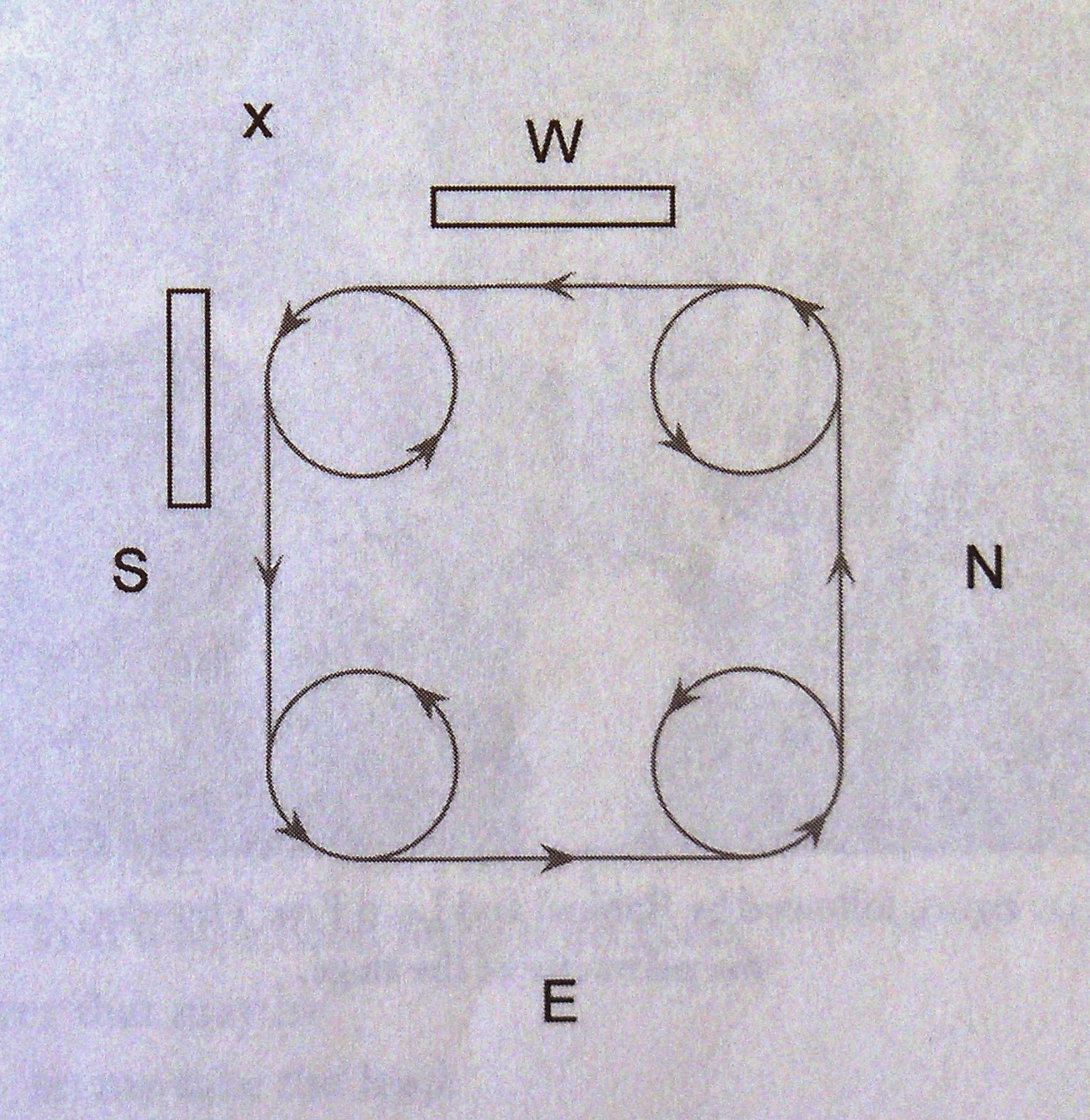
In 1952 Arthur Newell Strahler (1918 - 2002), a professor of geoscience at Columbia, published an influential article entitled "Hypsometric (Area-Altitude) Analysis of Erosional Topography" in Geological Society of America Bulletin 63. Strahler introduced a numbering system he called "stream order" to quantify the hierarchical branching networks that typify watercourses in drainage basins. A 1st order stream is very small and has no tributaries. The confluence of 2 or more 1st order streams creates a 2nd order stream. If a 1st order stream flows into a 2nd order stream, the result remains a 2nd order stream. But, when 2 or more 2nd order streams converge they form a 3rd order stream. Obviously, as a stream increases in upstream network complexity its stream order number increases.

The Allegheny and Monongahela are both 7th order streams as they converge at Pittsburgh, Pennsylvania. The Ohio is an 8th order stream at its confluence with the Mississippi at Cairo, Illinois. The Columbia is a 9th order stream as it discharges into the Pacific downstream from Portland, Oregon. The Mississippi is a 10th order stream at its mouth below New Orleans. The Nile is an 11th order stream as it flows through Egypt into the Mediterranean. The Amazon, largest river on earth, is a 12th order stream by the time it reaches the Atlantic.
Image may be NSFW.
Clik here to view.
Strahler Stream Order Classification System
Stream order has proven so useful it has become a global standard among limnologists. In contemporary usage, 1st - 3rd order watercourses are called headwaters streams or small streams. 4th - 6th order streams are called medium streams. 7th - 12th order streams are considered significant rivers or large streams. The Usumacinta, our candidate for river Sidon, is a 7th order stream. Other 7th order streams of note include the Colorado, Hudson, James, Potomac, Rio Grande, Susquehanna, and Trinity, The Tennessee is an 8th order stream, as is the Rhone south of Lyon, France. The Missouri is a 9th order stream by the time it reaches St. Louis as is the Illinois which joins the Mississippi 37 kilometers upstream.

The journal of the International Society of Limnology (SIL from the Latin) is Inland Waters. An important article appeared in Inland Waters (2012) 2 entitled "Global Abundance and Size Distribution of Streams and Rivers." It was written by John A. Downing of Iowa State University and 9 other co-authors from 6 different countries. Depending heavily on satellite imagery, they have compiled data estimates from more than 36 million streams of water across the planet. Their results show startling consistency that will help us understand what to expect as we analyze the Sidon.

Image may be NSFW.
Clik here to view.
J.A. Downing, et al. Anaylsis of all Streams Worldwide
Going from left to right, the first column is the Strahler stream order number. The second column is the total number of streams of surface water on the planet. The third column is the mean stream length from the source in kilometers. The fourth column is the combined length of all streams in kilometers and the fifth column is the mean stream channel width in meters. There is only one 12th order stream on earth, the  Amazon, while there are an estimated 28.55 million 1st order streams. These tiny brooks average 1.6 km in length and .8 meters in width. It is important to note that only one of the five 11th order streams - the Nile - is an independent river flowing to the sea. The other four 11th order streams are all tributaries of the Amazon. And, only three of the 10th order streams are independent rivers flowing to the sea, the Mississippi being one of them and the Niger in western Africa another. The other twenty 10th order streams are all tributaries of either the Nile or the Amazon.

These columns demonstrate what the authors call "well-defined scaling laws" that apply to branching patterns "applicable across diverse geological and geographical regions." For example, column two in the chart shows generally a 1 to 5 relationship between main streams and lesser streams of a lower order. In other words, any given stream will have an average of five tributaries of the next lower order. Column three shows generally a 1 to 2 relationship between tributaries and the length of their main stream. In other words, as two streams of a lesser order join, the resulting higher order stream will be on average twice as long as the tributaries. The actual branching algorithms involve more elegant math, but you get the idea. Drainage basins, like many other kinds of networks with branches and nodes, follow the tenets of branching theory whose laws and coefficients are so consistent as to be "tautologous" and "statistically inevitable" (J.A. Downing, et al.). Trees and blood vessels also follow branching theory laws.

Any given river may vary considerably from the norm. This chart shows the relationship between stream order and width for 400+ well-documented main streams. The dotted line plots median stream channel width in meters with data points scattered in normal distribution patterns.
Image may be NSFW.
Clik here to view.
J.A. Downing, et al. Analysis of 400+ Well-Known Streams
The relatively narrow Nile, the only 11th order main stream on earth, is an obvious outlier. Wetter regions have wider streams. For example, one study of the River Tyne basin in NE England found 1st order streams with a mean channel width of 3.5 meters and 2nd order streams with a mean channel width of 6 meters.

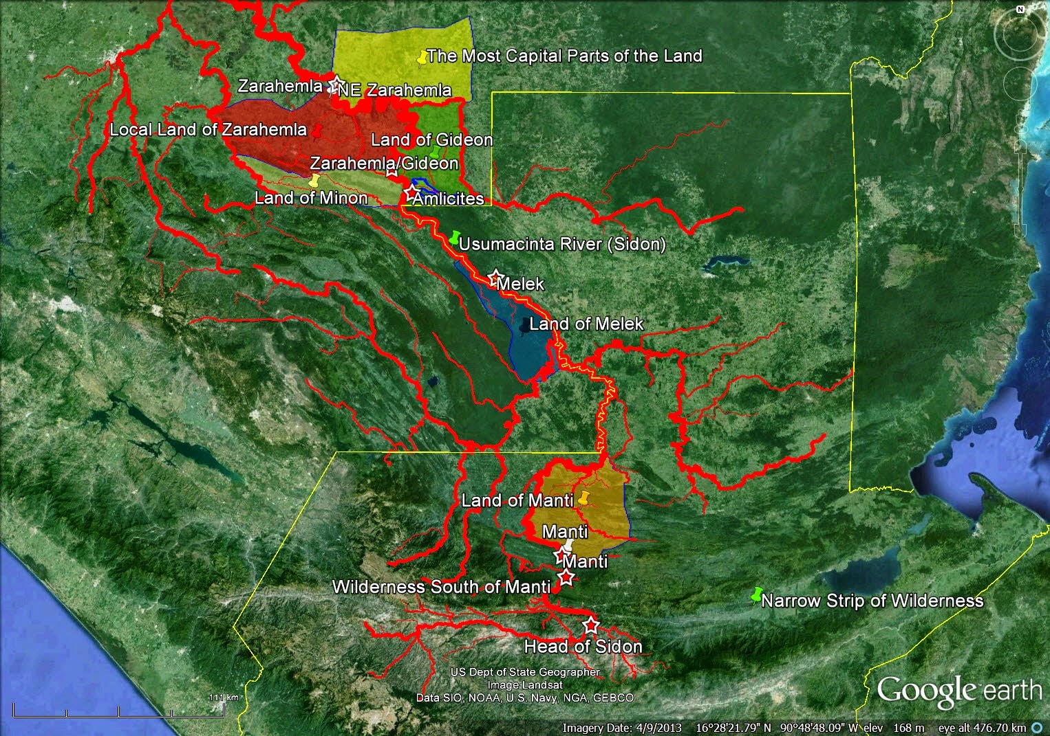
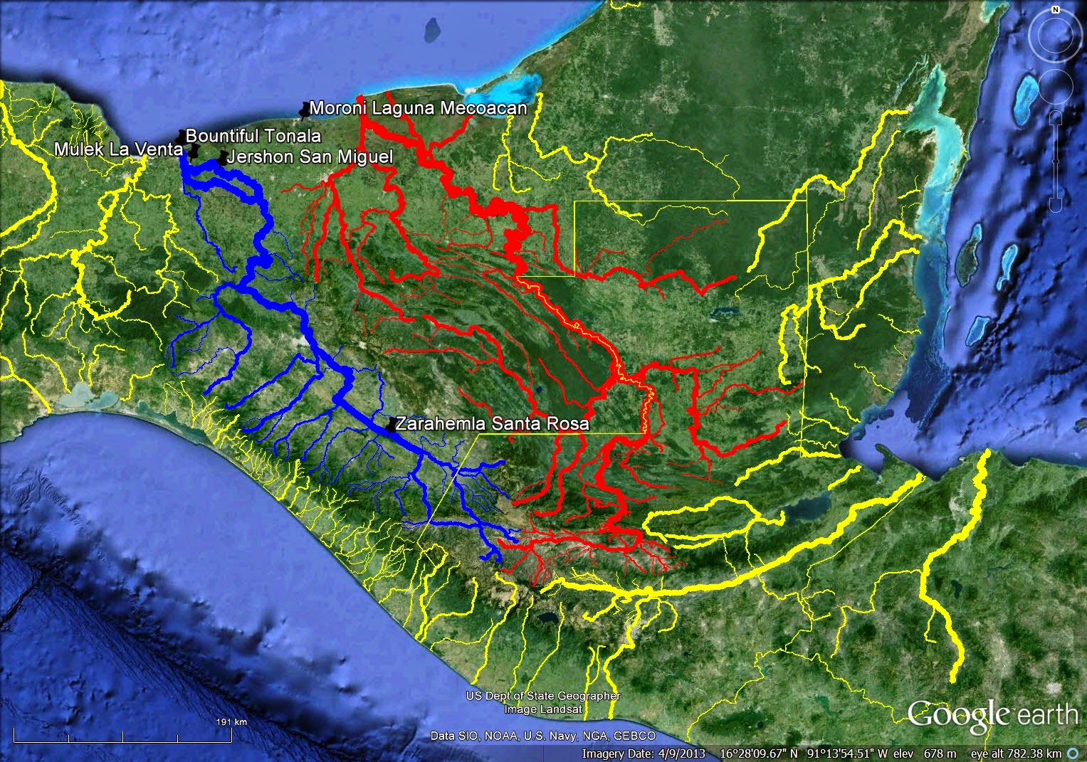
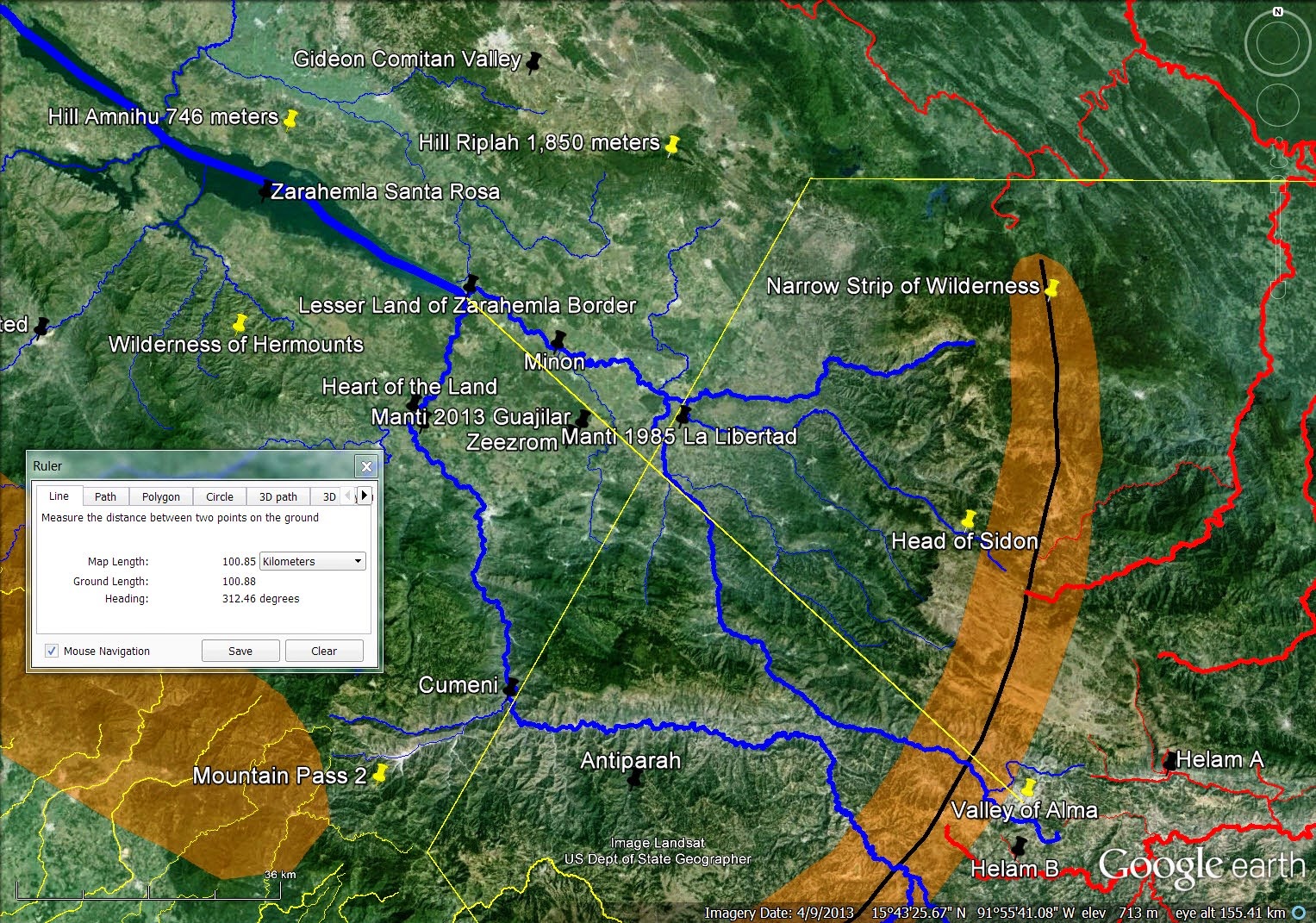
So what does all this imply for the river Sidon in the Book of Mormon? We know that Almaand his converts traveled a distance of 21 Nephite "days" to get from the city of Nephi to the local land of Zarahemla Mosiah 23:3, Mosiah 24:20, Mosiah 24:25. Our best estimate of the distance they traveled in one day is 15 air (straight-line) kilometers (see the blog article Land Southward Travel Times). This makes the city of Nephi/local land of Zarahemla distance about 320 air kilometers. We know the head of Sidon was south of Manti in the narrow strip of wilderness that separated the greater lands of Nephi and Zarahemla Alma 22:27, Alma 22:29, Alma 43:22, Alma 50:11. So, the distance head of Sidon/local land of Zarahemla probably did not exceed about 250 air kilometers. How far was it from the local land of Zarahemla to the sea? The land Bountiful lay north of the local land of Zarahemla Alma 22:29 (see the blog article Downstream from Zarahemla). The distance local land of Zarahemla/seacoast probably did not exceed about 200 air kilometers. So, the entire length of the river from head of Sidon to the sea likely did not exceed about 450 air kilometers. According to the chart above, we would expect the river Sidon to be a 7th or 8th order stream. A 9th order stream (mean global length 1,256 kilometers) seems long, even taking sinuosity (the tendency of a river to meander) into account. A 10th order stream (mean global length 2,891 kilometers) is entirely out of the question. Keep in mind there are only 5 rivers on earth that are 10th, 11th or 12th order streams flowing to the sea. Conversely, a 6th order stream (mean global length 103 kilometers seems short. A 5th order stream (mean global length 45 kilometers) is  entirely out of the question.

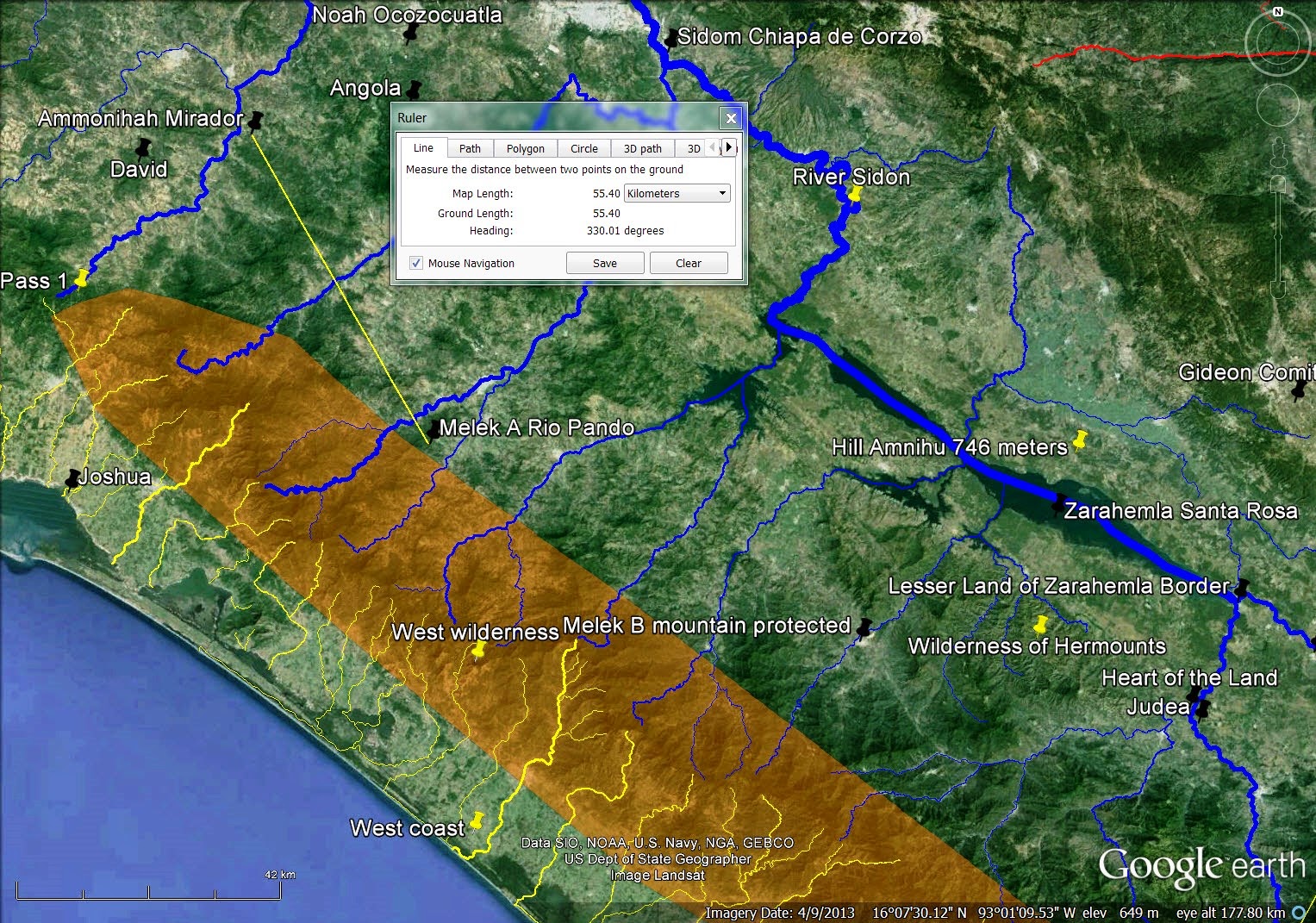
The fact that our candidate for Sidon - the Usumacinta - is a 7th order stream puts it in the ballpark of reasonableness. From our head of Sidon (the Salama/Chixoy Negro confluence) to salt water at the mouth of the Palizada (distributary of the Usumacinta) on the Laguna de Terminos is 382 air kilometers and to the principal mouth of the Usumacinta at Frontera is 435 air kilometers or 936 river kilometers. Principal tributary, the Chixoy Negro, adds another 175 river kilometers for a total length source to mouth of 1,111 kilometers. The Usumacinta, 7th largest river on earth by annual volume of water discharged (115 billion cubic meters which includes the Mezcalapa - Grijalva as a tributary in modern times), is a very large 7th order river.
Image may be NSFW.
Clik here to view.
Usumacinta - Candidate for River Sidon
Geographers place the head of the Usumacinta at the Pasion Confluence which is 328 air kilometers or 590 river kilometers from the principal mouth at Frontera, Tabasco.

Stream orders point out another important characteristic of water flow nomenclature. Headwaters streams (1st, 2nd & 3rd order) are generally not called rivers. They may be brooks, creeks, rivulets, forks, runs, burns or becks, but not rivers. The term "river" implies a certain size and a minimum level of upstream network complexity. Large streams (7th order or higher) are universally called rivers. Medium streams (4th - 6th order) are sometimes called rivers based on local custom. If a stream flows to the sea it is more likely to be called a river. If a stream is wide or carries a relatively high volume of water it is more likely to be called a river. These are the rivers of England. The noted Thames flowing past London is a 5th order stream, as are most English rivers. The Severn, longest river in the UK at 354 kilometers, is a 6th order stream.
Image may be NSFW.
Clik here to view.
The Rivers of England
The language of the Book of Mormon text that fell from the lips of the Prophet Joseph is now thought to be Early Modern English. See the article "Early Modern English." On the streets of London when Shakespeare was a child (ca. A.D. 1570) it is unlikely the term "river" would have referred to a stream smaller than 5th order.

The map above shows that many of England's rivers are longer than the 44.8 kilometers we would expect given the mean length of 5th order streams worldwide. The Thames, for example, is 346 kilometers long (7.7 X mean), the Trent measures 297 km (6.6 X mean) and the Great Ouse runs for 230 km (5.1 X mean). Compare that with our Sidon, which at 1,111 kilometers, is 4.7 X the global mean length of 7th order streams (237.4 km).

The following two images are from a spreadsheet listing well-known 7th order streams from 5 different countries.
Image may be NSFW.
Clik here to view.
Length of Selected 7th Order Streams a
56 rivers comprise our sample set.
Image may be NSFW.
Clik here to view.
Length of Selected 7th Order Streams b
8 7th order streams in our sample are longer than the Usumacinta, although none carries a greater volume of water.

Additional relevant information is in the article "OED on Rivers."

Sinuosity Index

One of the ways earth scientists classify rivers and streams is by their degree of deviation from a straight line. This metric is called sinuosity index or sinuosity coefficient. It is a simple calculation in this day of powerful geographic information systems such as Google Earth. You divide river kilometers by air (straight line) kilometers. A stream section (specialists typically call it a 'reach') with a sinuosity index less than 1.05 is nearly a straight line. Man-made canals achieve this level of rectitude, but it rarely occurs in nature. A stream reach with a sinuosity index between 1.05 and 1.25 is winding. A stream reach with a sinuosity index between 1.25 and 1.5 is twisting but still has low sinuosity. A stream reach with an index of 1.5 or more has high sinuosity and is meandering. A sinuosity index higher than 2 indicates extreme meandering. An S curve with identical 270 degree oxbows (270 degrees is 3/4 the circumference of a circle) has a sinuosity index of 3.33. If the oxbows close to 300 degrees, the sinuosity index increases to 5.24 and if they reach the very tight 330 degrees, the sinuosity index increases further to 11.13. In reality, stream reaches longer than 10 kilometers with a sinuosity index higher than 3 are rare.

There is generally an inverse relationship between slope gradient and sinuosity. Steeper slopes tend to produce straighter stream flows. Gentler slopes mean the stream is more susceptible to resistance in the channel (heavy vegetation is a prime source of resistance). Higher resistance creates more sinuosity.

We saw in the article "Water Fight on the River - Round Five" that higher sinuosity index numbers correlate with more traveler disorientation. In other words, the more a river meanders, the more likely a traveler is to get lost trying to follow it.

There are two places in the Book of Mormon text that are associated with travelers getting lost. One is the land of Manti which first appears chronologically ca. 90 B.C. Alma 22:27 as the southernmost outpost of Nephite settlement along the central Sidon corridor. All the narratives about travelers getting lost pre-date Manti. Once Manti was settled and the route Zarahemla/Manti was established via Gideon, travel along the central Sidon corridor became routine Alma 17:1.

The land of Helam is also associated with traveler disorientation. Both the priests of Noah and their Lamanite army overlords had to ask Almafor directions from Helam back to the land of Nephi Mosiah 23:35-36.

This means it is likely that both the lands of Manti and Helam are located in regions where the Sidon has high sinuosity index numbers.

In our correlation, the lands of Manti and Helam are both bounded by the Chixoy which has a very high sinuosity index of 2.58.
Image may be NSFW.
Clik here to view.
Sinuosity Indices along Reaches of the Proposed River Sidon
The Chixoy meanders and changes direction through sparsely-populated, hilly country covered with thick vegetation and tall trees. The entire main stem of the Usumacinta from source to mouth is an unusually sinuous river with an overall sinuosity index of 1,111/386 = 2.88.
Image may be NSFW.
Clik here to view.
Sinuosity Index = 2.88 along Entire Length of Proposed River Sidon
That portion of the river we think the Nephites called the Sidon (Chixoy/Salinas/Usumacinta) also has very high sinuosity (936/435 = 2.15).
Image may be NSFW.
Clik here to view.
Sinuosity Index = 2.15 along Proposed Nephite Rivr Sidon
Long distances, high sinuosity, low population density, hilly terrain, high forest canopies - the Chixoy/Salinas/Usumacinta region has many characteristics that make it easy for even seasoned travelers to get lost.

Main Stem

The main stem of a river is the principal channel from source to mouth, the channel where movement downstream causes the Strahler stream order number to increase by increments of one. If a river has many tributaries, and if the tributaries themselves are large streams, determining which channel is the main stem can be challenging as a traveler ascends or descends riverside trails. For example, suppose you were a traveler trying to go upstream on the Sidon from the local land of Zarahemla to the land of Nephi. As you came to this point, which we correlate with territory between Melek and Manti, would you correctly identify the main stem of the river?
Image may be NSFW.
Clik here to view.
Lacantun/Usumacinta Confluence Eye Altitude 1.44 Kilometers
Cartographers identify the main stem of a river with a thicker line on their map. We have followed this convention in the 384 streams we have plotted to date in our Google Earth repository of Mesoamerican watersheds. Imagine the difficulty, though, a traveler on the ground would have identifying the main stem of their target river in this region which we correlate with territory between Melek and Manti.
Image may be NSFW.
Clik here to view.
Chixoy/Salinas Confluence with the Pasion to Form the Usumacinta with
the Lacantun Confluence 42 River (17 Air) Kilometers Downstream
Is it any wonder Ammon and his 15 strong companions wandered in the wilderness Mosiah 7:4 as they attempted to navigate this cacophony of rivers? When we add in the additional streams plotted via NASA satellite remotely sensed elevation data, this landscape of approximately 12,000 square kilometers appears even more challenging.
Image may be NSFW.
Clik here to view.
Chixoy/Salinas Usumacinta/Lacantun Confluence Area
with Remotely Sensed Streams Plotted
Difficulty identifying the main stem of the Sidon almost certainly contributed to the traveler disorientation described in the Nephite annals.

Streamflow

Streamflow, aka discharge, aka channel runoff, is the volume of water in a stream flowing past a point in a specified period of time. The international standard unit of measure for streamflow is cubic meters per second. River discharge varies greatly from the rainy season to the dry season, so the most common comparative metric is annual average cubic meters per second. Obviously, streamflow in a channel increases as tributaries join the stream so the location where the flow was measured is an important factor. Streamflow for some rivers of interest expressed in annual average cubic meters/second measured at the mouth.
  • Amazon (world's largest river by far) 209,000
  • Congo (largest river in Africa) 41,200
  • Orinoco (2nd largest river in South America) 36,000
  • Saint Lawrence (drainage includes the Great Lakes) 16,800
  • Mississippi (drains 31 states & 2 Canadian provinces) 16,792
  • Columbia (drains 7 states & 1 Canadian province) 7,500
  • Usumacinta (our proposed Sidon) 4,774
  • Papaloapan (our proposed Ripliancum Ether 15:8) 2,609
  • Mezcalapa - Grijalva (John L. Sorenson's candidate for Sidon) 2,158 (tributary of the Usumacinta in modern times)
  • Coatzacoalcos (part of our proposed Land Northward/Land Southward boundary) 1,064
Following a battle south of Manti, the Nephite victors disposed of Lamanite dead by throwing their bodies into river Sidon whose waters carried the corpses to the sea Alma 44:22. Manti was the southernmost Nephite settlement along the central Sidon corridor. It was not far from the head of Sidon in the narrow strip of wildrness. Streamflow in the Sidon at the point of battle was adequate to carry large numbers of dead bodies hundreds of kilometers northward to the ocean. This means the Sidon south of Manti, not far from the river's head, was already a large and powerful stream. We correlate the city of Manti with the site of Chama about 30 air kilometers NW of Coban in Alta Verapaz. We think the Captain Moroni/Zerahemnah battle took place about 11 air kilometers south of Chama on the Chixoy. See the blog article "Manti."
Image may be NSFW.
Clik here to view.
Proposed Moroni/Zarahemnah Battlefield
The Chixoy River at this point has an annual average streamflow of 756 cubic meters/second. This makes it larger than the Colorado River at Lake Havasu, Arizona which (since 1971) is spanned by the original London Bridge.

Test #9 River Sidon

Compiling everything we have learned about river Sidon from the text and from the geomorphology of earth's rivers, we believe river Sidon will show these 23 characteristics identified below as 1 to 23
with aqua shading.

River Sidon is the only New World river mentioned by name in the text. Nephites in the land southward operated hemispherically, from sea to sea Alma 22:27. From this we infer that river Sidon is the dominant stream in the land southward 1.

Book of Mormon lands in the New World are described as well-watered Mosiah 8:8, Mosiah 23:4, Alma 50:29Helaman 3:4, 3 Nephi 9:7, 4 Nephi 1:9Mormon 6:4, Ether 15:8 with verdant forests 1 Nephi 18:25, Enos 1:3, Ether 10:19 supporting a significant lumber industry Alma 50:2, Helaman 3:10, abundant wildlife 1 Nephi 18:25, 2 Nephi 5:24, Alma 2:37, Ether 10:21 and large human populations 1 Nephi 12:1, Alma 2:27, Mosiah 8:8Mormon 1:7, Ether 10:21. Drought was unusual and catastrophic Helaman 11:6Ether 9:30. Both cases of drought mentioned in the text were caused not by normal weather patterns, but by divine intervention Helaman 11:4-6, Ether 9:28-30. From this we conclude the river did not flow through a desert or semi-arid region. Average annual precipitation in the river Sidon drainage basin is equal to or greater than the planet-wide mean 2.

The text of the Book of Mormon that fell from the lips of the Prophet Joseph was Early Modern English (see the blog article "Early Modern English"). In England in the 1500's the term "river" referred to a large stream with a Strahler Stream Order number of 5 or higher (see the blog articles "Strahler Stream Order" and "OED on Rivers"). Based on this lexical evidence, river Sidon has a Strahler Stream Order number of 5 or higher 3.

River Sidon flowed generally from south to north 4 (See the blog aritcle "River Sidon South to North").

We have estimated the straight-line (air) distance between the city of Nephi and the local land of Zarahemla at 320 kilometers (see the blog article "Land Southward Travel Times"). Land Bountiful was north of the local land of Zarahemla Alma 22:29. Land Bountiful was a coastal entity Alma 22:32-33, Alma 27:22Alma 63:5. The east-west narrow strip of wilderness separated the greater land of Nephi on the south from the greater land of Zarahemla on the north Alma 22:27. The head of Sidon was in this narrow strip of wilderness Alma 22:27-29. This means the head of Sidon was between the city of Nephi and the local land of Zarahemla. See the blog article "The Narrow Strip of Wilderness." This means the air distance from the head of Sidon to its mouth at the seacoast was probably not less than 160 kilometers (320/2) or greater than 640 kilometers (320x2) 5.

There is a documented relationship between Strahler Stream Order number and river length (See the blog article "Strahler Stream Order"). Based on reasonable distances for the total extension of Nephite lands, we would expect the Sidon to be either a 7th or an 8th order stream 6.

There is a documented relationship between Strahler Stream Order number and river width (See the  blog article "Strahler Stream Order"). Based on many examples known to science, we would expect the Sidon near its mouth to have a width in excess of 50 meters but less than 1,000 meters 7.

River Sidon in the text is a unitary stream. Neither tributaries nor distributaries are mentioned. There are no branches nor forks. This implies Sidon from head to mouth flows generally in one principal direction (See the section "Directionality" in the blog article "OED on Rivers") 8.

Test #10 Crossing Sidon

Seven passages in the text use a variant of the word "cross" to describe movement over Sidon. The word "ford" is not attested. All passages are in the book of Alma and all describe large groups in a military context. See the blog article "Crossing Things." These are the movements in textual order.
  • Nephite forces under Almacrossed Sidon from east to west from Gideon into the local land of Zarahemla just north of its border with Minon Alma 2:27, Alma 2:34-35
  • Lamanite forces crossed Sidon from west to east in wilderness south of Manti Alma 16:6
  • Zoramand his Nephite forces crossed Sidon from west to east from the local land of Zarahemla into Gideon, then marched south to the wilderness south of Manti Alma 16:7
  • Lamanite forces under Zerahemnah came around the north side of hill Riplah, down a valley and crossed Sidon from east to west. Lehi2 and his men engaged the Lamanites from their rear, while across Sidon Moroniand his forces engaged them at their front. Alma 43:35, Alma 43:40
  • Lamanite forces dug in along the southwestern border of Nephite lands were afraid to cross over the head of Sidon to mount an attack on Nephihah Alma 56:25
Large rivers typically have a limited number of places where crossing is practical. Steep canyon walls, swift currents or lateral wetlands make crossing difficult and hazardous. Because of this, the battlefield where Zoramengaged the Lamanite invasion force returning from Ammonihah + Noah and the valley where  Lehi2 drove Zerahemnah's men into the river are almost certainly the same place. Both are described as the wilderness south of the land of Manti Alma 16:6, Alma 43:27, 32. By the same token, the place where Nephite forces under Alma2 crossed from Gideon into the local land of Zarahemla and the place where Nephite forces under Zoram2 crossed from the local land of Zarahemla into Gideon are almost certainly the same crossing.

This leaves us with only 3 actual river crossing locations.
  1. Local land of Zarahemla just north of Minon to the west, land of Gideon to the east
  2. Opposing valleys west and east of the river in wilderness south of Manti
  3. Head of Sidon
This is our correlation showing all 3 crossings as stars on the modern map.
Image may be NSFW.
Clik here to view.
Three River Crossing Points Described in the Text
In our age, when people want to cross a river regularly, they build a bridge. There are 11 bridges over the Chixoy/Salinas/Usumacinta river from the head of the Chixoy to the mouth of the river at Frontera, Tabasco. The map below shows the bridges, marked with a square icon. Some archaeologists are convinced the Maya built a suspension bridge over the Usumacinta at Yaxchilan. 10 meter foundation platforms that may have supported bridge towers are still visible in the river at low water. We call this tantalizing possibility the "Ancient Yaxchilan Bridge." See point #15 in the blog article "The Usumacinta/Sidon Correlation" for an artist's rendering of the hypothesized 7th century A.D. bridge.
Image may be NSFW.
Clik here to view.
1 Possible Ancient & 11 Modern Bridges over the Proposed Sidon
Zooming in, we see that a modern bridge has been constructed at each of the 3 precise locations where our model predicts a Book of Mormon river crossing.
Image may be NSFW.
Clik here to view.
Boca del Cerro Bridge
Boca del Cerro is on the fall line where the mountains end and the coastal plain begins.
Image may be NSFW.
Clik here to view.
La Union Bridge
La Union is north of Cerro Pampajche which we correlate with Hill Riplah and south of the site of Chama which we correlate with Manti.
Image may be NSFW.
Clik here to view.
Bridge over Chixoy Dam
Chixoy Dam is where the Chixoy - Negro, Salama, Carchela and Santa Gertrudis all come together to form the Chixoy.

These were strategic places in Book of Mormon times. They are strategic places today which is why bridges have been built there.

In addition, the text describes other river crossings whose locations we can deduce.
  • Nephite forces under Alma2 crossed Sidon from west to east from the local land of Zarahemla to Gideon to engage the Amlicites on Hill Amnihu Alma 2:16-17. This is the same crossing location as #1 in the list above.
  • Amlicite survivors of the battle on Hill Amnihu crossed Sidon from east to west from Gideon to Minon to rendezvous with their Lamanite allies Alma 2:24. This location is not far from the valley of Gideon which itself was not far from Hill Amnihu. It has to be upriver from the main drainage basin in the Valley of Gideon because the Nephite army was encamped for the night in the Valley of Gideon and their retinue would have monitored the path from the army campsite back to the local land of Zarahemla.
  • On his first missionary journey beyond the local land of Zarahemla, Alma2 crossed Sidon from west to east from the local land of Zarahemla to Gideon Alma 6:7. This is the same crossing location as #1 in the list above. Upon his return from Gideon, Alma2 crossed Sidon from east to west, again in the same location Alma 8:1
  • After Alma2 & Amulek finished their missionary work in Sidom they crossed over Sidon from east to west and resided for a time in the local land of Zarahemla Alma 15:18. We know Sidom was in the east (see the blog article "Ammonihah, Noah & Sidom all East of Sidon"). It was close to Ammonihah Alma 15:1. We know Ammonihah was east of Gideon because Nehor was passing through Gideon to return to Ammonihah to preach Alma 1:7 when he murdered Gideon in the elderly hero's eponymous city. This means it is likely the local land of Zarahemla, Gideon, Ammonihan and Sidom were at similar latitudes. And this means Alma2 & Amulek probably crossed over Sidon at the same crossing location as #1 in the list above.
  • Alma2 was journeying southward from Gideon to Manti when he met the sons of Mosiah2 returning from their 14 year mission to the Lamanites Alma 17:1. Since Alma2 had his home in the local land of Zarahemela Alma 8:1, Alma 15:18 he crossed over Sidon from west to east at the same crossing location as #1 in the list above to begin his southward journey from Gideon.  Alma2 returned to his home in the local land of Zarahemla with his old friends, the sons of Mosiah2, by crossing yet another time across Sidon from east to west Alma 27:20 at the same crossing location. It is worth noting that Zarahemla east over Sidon to Gideon and then south to Manti seems to have been a standard route at this time in Nephite affairs. Zoram2 and his men took this same route to travel from the local land of Zarahemla to Manti Alma 16:7. The fact that Alma2 and the sons of Mosiah2 met on the trail going in opposite directions shows that the Gideon to Manti route had become standardized by ca. 77 B.C.
  • Korihor traveled from the local land of Zarahemla over Sidon eastward  to Jershon Alma 30:19 which was in the NE corner of Nephite lands just south of land Bountiful Alma 27:22. This makes it likely Korihor crossed Sidon to the NE through the most capital parts of the land en route to Jershon just as Coriantumr did about 23 years later en route to the city of Bountiful Helaman 1:23.
  • The people of Ammon (Anti-Nephi-Lehi) traveled from Jershon by the east sea across Sidon from east to west into the land of Melek Alma 35:13. There was a river crossing at Melek because Alma2 went from Melek west of Sidon north across the NW flowing river to Ammonihah east of Sidon Alma 8:6.
  • The Lamanites under Zerahemnah came in a sweeping motion southward from Jershon into the wilderness south of Manti. They intended to cross over Sidon from west to east at Manti to mount a surprise attack Alma 43:24. That is why they had to cross Sidon from east to west in the wilderness south of Manti Alma 43:35
  • The 4,000 Lamanites captured by Moroniand Parhoran (Yale text orthography) NW of Nephihah were sent to live with the people of Ammon in Melek Alma 62:17. They likely crossed over Sidon from east to west at Melek.
This gives us four more crossing points to add to our list. Sidon crossing locations attested or implied in the text from north to south:
  1. NE of the city of Zarahemla toward the most capital parts of the land
  2. Local land of Zarahemla just north of Minon to the west, Gideon to the east
  3. Amlicites from Gideon west to Minon
  4. Melek
  5. Manti
  6. Opposing valleys in the wilderness south of Manti
  7. Head of Sidon
This is a map of our correlation of the 7 river crossings described in the text shown as stars.
Image may be NSFW.
Clik here to view.
Seven River Crossing Locations Described in the Text
We saw above that three of the proposed Book of Mormon river crossings are right where a modern bridge stands today. That pattern continues.
Image may be NSFW.
Clik here to view.
Chama Bridge
Our proposed Manti crossing is at Chama Bridge.
Image may be NSFW.
Clik here to view.
Ancient Yaxchilan Bridge
Our proposed Melek crossing is right where some archaeologists place the Ancient Yaxchilan Bridge.
Image may be NSFW.
Clik here to view.
Puente Usumacinta
And, finally, our proposed Northeast Zarahemla crossing is precisely where the largest bridge over the Usumacinta River stands today, the Puenta Usumacinta that carries Mexican Federal Highway 186 coming from Villahermosa and going to Chtumal on the Caribbean. The ruin we correlate with the Nephite city of Bountiful, by the way, is in a suburb of Chetumal.

The only one of our Book of Mormon river crossings without an ancient or modern bridge is the point south of the Valley of Gideon where the Amlicites went over the river to join their Lamanite comrades who had come undetected up the central Sidon corridor into Minon.

See point #40 in the blog article "Test #9 River Sidon" for a description of Ron Canter's 2004 Rio Usumacinta Navigation Survey. Experienced rivermen scientists found six places along the upper Usumacinta where wear patterns from ropes on mooring stones indicated canoes tied up in that location during Maya times. On the map blow we call these six places "bollards." The survey also found six places where cross currents made for easy canoe transit back and forth across the river. On the map below we call these six places "ferries."
Image may be NSFW.
Clik here to view.
Bollards and Ferries along the Usumacinta from Yaxchilan to Pomona
Our proposed Amlicite crossing is precisely where the 2004 Rio Usumacinta Navigation Survey found ancient bollards and excellent crossing conditions at San Jose Usumacinta.
Image may be NSFW.
Clik here to view.
San Jose Usumacinta Bollards & Ferry
The survey also found many bollards and very good crossing conditions at Yaxchilan. So, all 7 of our proposed Book of Mormon river crossing points have one or more of the following validations:
  • an ancient or modern bridge
  • ancient mooring stones where canoes were tethered
  • cross currents and eddys that allowed easy paddling across the river
When Cortez came through Tabasco and the Peten in 1524 en route to Honduras, he and his large military entourage including cavalry and cannon crossed many rivers. In every case they crossed on hastily-constructed pontoon bridges. The Spaniards marveled how quickly their native allies were able to construct such bridges, and how sturdy the structures were as heavy loads passed over them. When the Spaniards conquered Guatemala, they found many rope suspension bridges in use by the indigenous peoples. When Europeans first entered the Soconusco (Pacific coast of Chiapas & western Guatemala) they found vast numbers of canoes stationed at river crossings that were available as a public utility similar to the way European cities provide fleets of bicycles for public use. So how did Nephites and Lamanites cross over Sidon? They absolutely did not wade across. The notion that Book of Mormon peoples forded the river like Mormon Handcart Pioneers crossing the Sweetwater is utter nonsense. Many smaller streams in Mesoamerica are too large for pedestrian fording. let alone the mighty Usumacinta. The Nephites and Lamanites crossed Sidon the same way the ancient Maya did and their descendants still do, in fleets of small watercraft or on bridges.

One more important point needs to enter our discussion of river crossings. There are certain places, typically inside steep canyons, where river crossings are rarely attempted. The terrain is simply too rough. Here is a map showing seven reaches of the Chixoy/Salinas/Usumacinta where crossings are unlikely.
Image may be NSFW.
Clik here to view.
Seven Canyons on the Chixoy/Salinas/Usumacinta
The 2004 Rio Usumacinta Navigation Survey found no evidence of ancient boat harboring along these difficult sections of the river. They did find one mooring stone that would have served to warp boats (pull them upstream with a rope tied to a stationary object) up Chicozapote Falls. None of our proposed Book of Mormon crossing locations fall within these problematic reaches of the river.

From the text we identified 7 unique places where Nephites and Lamanites crossed Sidon. We then compared these 7 points with the locations of 1 ancient and 11 modern bridges, 6 places with ancient canoe mooring stones, and 6 places where currents and eddies favor river crossings. We then compared our 7 Book of Mormon locations with 7 canyons where river crossings would be difficult and hazardous. We found 100% correspondence between proposed Book of Mormon locations and known likely locations for river crossings. We found zero correspondence between proposed Book of Mormon river crossings and difficult canyon terrain. We submit that any viable Book of Mormon map should show a similarly high degree of fit to the text with compelling external validation.

    Hill Riplah

    I appreciate Ryan Williams' insights that sparked the research behind this article. Ryan served his mission in Guatemala and is exceptionally well-traveled in and well-informed about the region.

    I have generally avoided the etymology of Book of Mormon geographic names or personal names because much of the material in print on this subject is highly speculative. The one exception to date in this blog is the wilderness of Hermounts. See point #4 in the article "Hermounts." I am not persuaded by the linkage some have suggested between the names 'Hermounts' and 'Tehuantepec'. See the blog article "Isthmuses" for the very late origin of the Nahuatl name 'Tehuantepec'.

    Ripliancum, on the other hand, is explicitly defined in the text. Ether 15:8 says the name meant "large, or to exceed all." Our correlate for Ripliancum, the Papaloapan delta in Veracruz, is the largest wetlands in our land northward. The Papaloapan is the 2nd largest river in Mexico by volume of water discharged. (The Usumacinta is the largest and the Mezcalapa-Grijalva which joins the Usumacinta in modern times is the 3rd largest.) The excellent Book of Mormon Onomasticon maintained by Paul Y. Hoskisson, Stephen D. Ricks, Robert F. Smith and John Gee offers etymologies for 'Ripliancum' meaning surpassing, outstanding, massive, strong and abundant. 'Riplah' likewise connotes fertile or abundant. This means hill Riplah Alma 43:31, 35 is probably a large hill like Ripliancum is a large river.

    Other hills of note in the text are the hill north of Shilom Mosiah 7:5, Mosiah 7:16, Mosiah 11:13, hill Manti in the local land of Zarahemla Alma 1:15, hill Amnihu east of Sidon in the land of Gideon Alma 2:15-17, hill Onidah in the land of Antionum Alma 32:4, and hill Raman-Cumorah Mormon 6:2-11, Ether 15:11 in the land northward. We will compare our correlate for hill Riplah with each of these other five. We have not as yet dealt with hill Shim Mormon 1:3, Mormon 4:23, Ether 9:3. Serious students of the text correlate Shim with various peaks from Puebla to southern Veracruz.

    This is a big picture overview of the six hills we will compare and contrast.
    Image may be NSFW.
    Clik here to view.
    Six Proposed Book of Mormon Hills
    We correlate the hill north of Shilom with 2,428 meter Cerro Tuncaj in Baja Verapaz. In this image the semi-opaque white terrain plane is set at an altitude of 2,200 meters. Areas showing through in natural color are higher than 2,200 meters elevation. 
    Image may be NSFW.
    Clik here to view.
    Proposed Hill North of Shilom
    Vertical rise from the Motagua = 1,800 meters
    Approximate area = 120 square kilometers
    Grade = 18% running north from the Motagua to the summit

    Following V. Garth Norman, we correlate hill Manti with 588 meter Cerro El Mirador just south of the ruins of Palenque in Chiapas. In this image the terrain plane is set at an altitude of 320 meters.
    Image may be NSFW.
    Clik here to view.
    Proposed Hill Manti
    Vertical rise from the Chacamax = 420 meters.
    Approximate area = 24 square kilometers
    Grade = 31% running north from the Chacamax to the summit

    We correlate hill Amnihu with 400 meter Sierra del Lacandon just east of Boca del Cerro Canyon in Tabasco. In this image the terrain plane is set at an altitude of 220 meters.
    Image may be NSFW.
    Clik here to view.
    Proposed Hill Amnihu
    Vertical rise from the Usumacinta = 380 meters.
    Approximate area = 18 square kilometers.
    Grade = 22% running northeast from the Usumacinta to the summit
    Grade = 39% running northeast from the Usumacinta to the 300 meter contour line
    Grade = 72% running east from the Usumacinta in Boca del Cerro Canyon to the 300 meter contour line
    For more about the battle that took place on Hill Amnihu ca. 87 B.C. see the blog articles "Gideon" and "Minon."

    We correlate hill Onidah with 650 meter Starkey Hill north of the Belize in Cayo. In this image, the terrain plane is set at an altitude of 550 meters.
    Image may be NSFW.
    Clik here to view.
    Proposed Hill Onidah
    Vertical rise from the Belize = 275 meters.
    Approximate area = 140 square kilometers
    Grade = 15% running north from the Belize to the summit

    Following John L. Sorenson & David A. Palmer, we correlate hill Ramah-Cumorah with 840 meter Cerro El Vigia near Santiago Tuxtla in Veracruz. In this image the terrain plane is set at an altitude of 350 meters.
    Image may be NSFW.
    Clik here to view.
    Proposed Hill Ramah-Cumorah
    Vertical rise from the Tilapan = 700 meters.
    Approximate area = 40 square kilometers
    Grade = 20% running west from the Tilapan to the summit

    We correlate hill Riplah with 2,060 meter Cerro Pampache in the great bend of the Chixoy in Alta Verapaz. In this image the terrain plane is set at an altitude of 1,560 meters.
    Image may be NSFW.
    Clik here to view.
    Proposed Hill Riplah
    Vertical rise from the Chixoy = 1,670 meters.
    Approximate area = 220 square kilometers
    Grade = 23% running north from the Chixoy to the summit
    Grade = 84% running east from the Chixoy to the 1,500 ,meter contour line
    Grade = 81% running southeast from the Chixoy to the 1,500 meter contour line

    There are several ways this impressive hill is surpassing, outstanding, massive, strong and abundant compared with its peers:
    • It has the largest surface area at 220 square kilometers
    • It has the steepest slopes at more than 80% on its west flank (100% is a 45 degree angle where run = rise)
    • It has the longest ridge line at 24 kilometers east to west
    Cerro Pampache between the Chixoy and the Cahabon is the largest detached hill in highland Guatemala.
    Image may be NSFW.
    Clik here to view.
    Proposed Hill Riplah in Context
    The image above has the terrain plane set to 1,500 meters elevation with the white layer at full opacity.

    If the etymology described above and our correlations are correct, Riplah is a highly appropriate name for this major upland which is home to one of Guatemala's premiere cloud forests.  

    To see how we think the Moroni1, Lehi2 and Zerahemnah battle played out around this unique hill, see the blog articles "Manti" and "Captain Moroni in Space and Time."

    Test #11 The Big Picture

    We previously published ten tests based on disprovable criteria that we believe any viable Book of Mormon New World correlation will pass. The ten articles are:
    For our eleventh test we zoom out to an eye altitude higher than 1,000 kilometers (1 Megametre) above the surface of the earth to identify Book of Mormon lands in their hemispheric context based on large-scale continental criteria. We number these criteria 1 - 10 and they appear in aqua below.

    Two land masses 1 are oriented not north and south but northward and southward 2 from each other Alma 22:31-32, Helaman 3:8, 3 Nephi 3:24, 3 Nephi 6:2, Mormon 2:29, Ether 10:21.

    Since a key distance within the land southward (city of Nephi to local land of Zarahemela) is on the order of 320 air kilometers (see the blog articles "Land Southward Travel Times" and "Plotting Alma") the distance the diligent Mosiah 8:8 Limhi explorers traveled probably did not exceed 2X that amount (see the blog article "Test #8 Limhi Expedition"). This means the distance from the city of Nephi to hill Ramah-Cumorah in the land northward probably did not exceed 640 air kilometers. Even allowing for generous interpretations of ambiguous passages such as Helaman 3:4 the extent of the world known to Nephite scribes prior to Moroni2's post-holocaust peregrinations probably did not exceed 2X the length of the Nephi/Ramah-Cumorah axis. This means the world of the Book of Mormon in the Western Hemisphere probably did not exceed 1,300 air kilometers in length at its maximum extent 3 and territory beyond those bounds was terra incognita as far as Mormon was concerned.

    If the land southward constituted approximately one-half of the Nephite known world we would expect a maximum extent on the order of 700 air kilometers. Any distance in the land southward exceeding 1,000 air kilometers is probably out of the question 4. Furthermore, the land southward has some island characteristics 2 Nephi 10:20 being nearly surrounded by water Alma 22:32 5. We interpret that phrase to mean at least 75% of the land southward is waterfront littoral as opposed to land bridge.

    The lands northward and southward are surrounded by four seas associated with the cardinal directions Helaman 3:8 6.

    Four entities explicitly run from the east sea to the west sea. In order from south to north they are:
    One entity, commonly thought to be continental in scope, explicitly does NOT run from the east sea to the west sea. The narrow (small) neck of land is a localized feature associated with only the west sea Alma 22:32, Alma 63:5. This does not mean there is not a substantial land bridge between the lands northward and southward. It just means the land bridge is not the feature the Book of Mormon calls the narrow (small) neck.

    1. In our correlation, two land masses conjoin at the Isthmus of Tehuantepec. Topographically the isthmus contains the pass between the Sierra Madre mountain ranges on either side of it.
    Image may be NSFW.
    Clik here to view.
    Proposed Nephite Known World
    Culturally the isthmus has been a dividing line for millenia. This map shows the Olmec heartland and the Maya area.
    Image may be NSFW.
    Clik here to view.
    Olmec Heartland and Maya Area
    Another rendering of Mesoamerica showing the limits of the Maya area.
    Image may be NSFW.
    Clik here to view.
    National Geographic December 1997
    Major cultural areas in Mesoamerica according to the Foundation for Ancient Mesoamerican Studies, Inc.
    Image may be NSFW.
    Clik here to view.
    FAMSI Map of Cultural Areas
    The cultural boundary at the Isthmus of Tehuantepec persisted into Aztec times.
    Image may be NSFW.
    Clik here to view.
    Aztec Empire at Conquest by Ian Mladjav
    The isthmian region continues to be a political boundary today. The modern line between Veracruz and Oaxaca northward and Tabasco and Chiapas southward is essentially the Maya/non-Maya line from antiquity.
    Image may be NSFW.
    Clik here to view.
    Modern Mexican State Boundaries
    Politically, Central America today consists of the countries between Guatemala and Belize northward to Panama southward. Physiographically, many geographers include the Mexican states of Tabasco, Chiapas, Campeche, Yucatan and Quintana Roo in Central America. Merriam Webster, for example, defines Central America as the territory between the Isthmus of Tehuantepec northward and the Isthmus of Panama southward.

    Our correlation of the Nephite land northward with Mexican territory north of the isthmus and the land southward with Mexican-Central American territory south of the isthmus has topographical, cultural and physiographical precedents. Criterion 1 satisfied.

    2. These are vectors we think the Nephites had in mind when they coined the terms "land northward" and "land southward."Both originate at the mouth of the Suchiate which forms the border between Mexico northward and Guatemala southward. We correlate this area with Lehi's landing.
    Image may be NSFW.
    Clik here to view.
    Northward Southward Azimuths
    The 315 degree vector passes through our narrow neck of land, the east-west Bountiful/Desolation line, and the Bountiful/Desolation line along the upper Coatzacoalcos. The 323 degree vector passes through our hill Ramah-Cumorah. Lands along these azimuths on either side of the Isthmus of Tehuantepec are clearly in a northward-southward relationship. Criterion 2 satisfied.

    3. We believe the world known to the Nephite record keepers extended from about Mexico City westward to about the Ulua River in modern day Honduras eastward. The air distance between these two at the points indicated is 1,256 kilometers.
    Image may be NSFW.
    Clik here to view.
    Straight Line Distance Mexico City to Ulua River
    Criterion 3 satisfied.

    4. Our correlation of the Nephite land southward extends from the Coatzacoalcos westward to the Ulua eastward, and from northern Yucatan northward to the Pacific coast of Guatemala southward. No straight line distance in this vast territory exceeds 955 kilometers.
    Image may be NSFW.
    Clik here to view.
    Proposed Land Southward Maximum Distances
    Criterion 4 satisfied.

    5. This is how we envision Mormon's description in Alma 22:32.
    Image may be NSFW.
    Clik here to view.
    Proposed Land Southward Nearly Surrounded by Water
    The total length of the red line on the map above is 3,808 kilometers. 3,363 kilometers are waterfront littoral. 445 kilometers are land bridge. This works out to be 88% water and 12% land. Criterion 5 satisfied.

    6. Our model has seas in each of the four directions just as the text describes.
    Image may be NSFW.
    Clik here to view.
    Four Seas in the Cardinal Directions
    Criterion 6 satisfied.

    7, 8, 9, 10. Moving from the south to the north, greater Nephi, the narrow strip of wilderness, greater Zarahemla and Bountiful are all continental entities running from sea to sea.
    Image may be NSFW.
    Clik here to view.
    Four Entities from Sea East to Sea West
    Criteria 7, 8, 9 and 10 satisfied.

    The correlation illustrated clearly fits all ten big picture textual criteria. We submit that any viable Book of Mormon model should display a similarly high degree of fit to the text.

    Geology of the Book of Mormon

    Tyler Livingston, recently named President of Book of Mormon Archaeological Forum, showed me a new book a few days ago. I immediately purchased a copy, read it, and wrote a favorable review on Amazon. The book is entitled Geology of the Book of Mormon by Jerry D. Grover, Jr., PE, PG.
    Image may be NSFW.
    Clik here to view.
    Important New Book
    Grover is both a geologist and an engineer. 222 pages of lavishly illustrated text are followed by 122 bibliographic refererences, one of which is this blog, and a 3 page index. The real glory of the book, though, are the 91 striking visuals, many of them from online sources. The cover features images of Popocatepetl, the most active volcano in Mexico, from the Mixtec Codex Vindobonensis C, aka Mexicanus I, and from the Toltec-Chicimec Codex Rios, aka Vaticanus A. The impressive cover photo is of a Chilean volcano that erupted in 2011. John L. Sorenson's son, Curtis, prepared the splendid maps in Mormon's Codex: An Ancient American Book (Salt Lake City: Deseret Book and Neal A. Maxwell Institute for Religious Scholarship, 2013). Grover worked with Curtis to enhance some of John's maps and figures 1 - 5, 82, 85, and 87 in Geology are either direct copies or adaptations of maps from Mormon's Codex.

    Seasoned professionals reading the Book of Mormonin light of their expertise often find exciting insights. See the blog article BMAF 2014 for discoveries Wade Miller made when he engaged the text based on his experience as a geologist and paleontologist. Miller's Science and the Book of Mormon (Laguna Niguel: KCT & Associates, 2010) explores fauna in pre-columbian Mesoamerica. See the blog article "The Legal Cases in the Book of Mormon" for another book I highly recommend. It contains insights Jack Welch gleaned through decades of experience in Biblical Law. The Book of Mormon has material enough for specialists in dozens of disciplines to study it in depth.

    Ben L. Olsen worked in Mexico, Guatemala and Belize as a petroleum geologist for Shell Oil Co. After taking a Book of Mormon tour with Joe Allen, Olsen wrote a small piece entitled "Some Thoughts Regarding Geology and the Book of Mormon." Bart J. Kowallis wrote an article entitled "In the Thirty and Fourth Year: A Geologist's View of the Great Destruction in 3 Nephi" that appeared in BYU Studies 37:3, 1997. In 55 pages he summarizes evidence from Papua, New Guinean oral traditions, an Egyptian stela ca. 1,500 B.C., and modern earth sciences to explain 3 Nephi 8-10 as an explosive volcanic eruption similar to Tambora (1815 Volcanic Explosivity Index - 7) or Krakatoa (1883 VEI - 6). That prompted Benjamin R. Jordan to write the short article "Many Great and Notable Cities were Sunk: Liquefaction in the Book of Mormon" that appeared in BYU Studies 38:3, 1999 where he describes a natural phenomenon that can sink coastal cities even without a tsunami.

    None of these previous geological overviews approaches the depth or scope of Grover's work. Geology of the Book of Mormon attempts not only to explain the natural disasters the Nephites described but also to help identify Book of Mormon cities based on the location of Mesoamerican tectonic plates, volcanoes, fault lines and hurricane tracks.

    This image from NASA's Goddard Space Flight Center shows the major tectonic plate boundaries that heavily influence volcanic and seismic activity on the planet.
    Image may be NSFW.
    Clik here to view.
    Global Plate Tectonic Boundaries
    The Book of Mormon area in Mesoamerica has a triple junction of the North American, Caribbean and Cocos Plates.
    Image may be NSFW.
    Clik here to view.
    North American, Caribbean and Cocos Plates Junction
    In Mexico and Guatemala the North American and Caribbean Plate boundary is known as the Cuilco- Chixoy-Polochic Fault. Slippage along this fault has created an east-west line of steep mountains we correlate with the narrow strip of wilderness in Alma 22:27. See the blog article "The Narrow Strip of Wilderness."

    A Book of Mormon Trifecta

    If the Book of Mormon geography problem is solved in this generation as I believe it will be, these three resources will prove pivotal:
    1. The 2009 Yale edition of the text edited by Royal Skousen. Based on the best scholarship currently available, this is as close as we can come to the words that fell from the lips of the prophet as he dictated to his scribes in the moment of translation. The Lord's target language was Early Modern English (A.D. 1470 - 1700+) and the translation process was largely controlled by a higher power. See the blog article "Early Modern English." We can take this text at face value, read with precision and ferret meaning from every word. This is our tool for textual analysis.  
    2. The Oxford English Dictionary. The OED, in process since 1857, is the ultimate authority on English. It can help us grasp the nuanced meanings of words and phrases as they were understood in the time of Shakespeare and the King James Bible. This is  our tool for lexical analysis. The combination of the Yale edition and the OED are still subject to interpretive assumptions. To understand our assumptions, see the blog articles "Plainness" and "Some Questions and a Rule."
    3. Google Earth. World's most widely-used geographic information system can quickly prove or disprove hypotheses. Is point A higher in elevation than point B? Is B east of A? How many air kilometers separate A from B? Where are the mountains? rivers? swamps? dense foliage? How high is the tree canopy? Are known mineral reserves nearby? Does an area exhibit wilderness characteristics? Where are the known archaeological sites in the area? How many square kilometers are in a tract of land? How many people live in the area today? What routes do the modern roads and railroads follow? These and dozens of similar questions can be answered with specialized data sets rendered in Google Earth. Then, as a model begins to come together, Google Earth is an ideal repository because most Book of Mormon students on the planet can access it with minimal effort and expense. This is our tool for spatial analysis.
    Our tool for chronological analysis, admittedly crude, is the timeline published in the 1980 and 2013 LDS editions of the text. We are aware of the excellent work being done by Randall P. Spackman ("The Jewish/Nephite Lunar Calendar" in Journal of Book of Mormon Studies 7/1, 1998) but have not yet incorporated it into our research methodology. Our tools for cultural analysis include such important works as John L. Sorenson's Mormon's Codex: An Ancient American Book (Salt Lake City: Deseret Book and the Neal A. Maxwell Institute for Religious Scholarship, 2013).

    The 2009 Yale edition hardbound costs $30 - $40 and a Kindle edition is available. The OED online edition costs $295 per year for an individual subscription in the US and Canada. Many libraries and academic institutions subscribe. Google Earth is free to download on Linux, Windows and Mac. The Google Earth Pro edition costs $399 per year for a single user license. The free version has 95% of the functionality in the paid version and will be adequate for almost all students of the Nephite text.

    Using all three resources extensively, we have analyzed a key feature in Nephite, Lamanite and Jaredite geography, the narrow (small) neck of land, from a variety of perspectives. A precis of this analysis illustrates the way the Book of Mormon trifecta can facilitate clear, definitive correlations based on data-driven, reproducible results. 
    • Since many people correlate the Isthmus of Tehuantepec with the narrow (small) neck, we used Google Earth and Microsoft Excel to list 53 well-known isthmuses in ascending order by width. Tehuantepec, at 216 km, is the widest isthmus in our sample set and may be the widest on earth. It is 10X the width of the mean and 73X the width of the median of our sample. As isthmuses go, Tehuantepec is huge, even gigantic. Its surface area (as defined by geographers) is 57,629 square kilometers which is nearly 3X the size of the modern nation of Israel. Correlating it with the diminutive language in the text (narrow, small) is ludicrous. See the blog article "Isthmuses."
    • Reading the text closely, we identified 17 occurrences of the word "narrow," 10 occurrences of the allied word "strait," and 50 occurrences of the word "small." Analyzing all passages containing these 77 occurrences, we deduced a reasonable upper limit for the width of the things being described. This included a preliminary look at 15 land forms in 6 different countries with the word "neck" in their name. Our results from this textual and spatial analysis: to be either "narrow" or "small" in Book of Mormon parlance a geographic feature will probably not exceed 5 km in width with 20 km the extreme upper limit of plausibility. See the blog article "Narrow and Small Things."
    • We then analyzed all occurrences of the word "neck" in the text and discovered an interesting passage (2 Nephi 18:8) where this word is used in a geographic context. Exegesis on this passage led us to conclude the Isaiah neck would not have exceeded 5 km in width and was probably closer to 2 km. See the blog article "Another Geographic Neck."
    • Immersing ourselves in the text, we identified 15 criteria any candidate narrow (small) neck must satisfy. Key findings: a) Orientation is generally southward to northward, b) The neck fronts one and only one sea - the west sea. c) The neck is near the east-west Bountiful/Desolation line that rises in the east and terminates at the west sea. d) The east-west line is situated in a place where the topography aids defense and can help a standing army control hostile southward-northward movement. e) The east-west line is on the order of 22.5 km in length according to our derivation of the standard Nephite unit of distance measure documented in the blog article "Land Southward Travel Times," f) The neck is near a harbor suitable for berthing and launching ocean-going vessels. g) The neck is near an important Olmec (Jaredite) archaeological site. h) The neck is near an inlet of the ocean or an outlet (mouth) where an inland saltwater lagoon breaches the coastal sandbar. i) Southward from the narrow neck is terrain suitable for a game preserve. j) The width of the neck does not exceed 5 - 20 km. Using Google Earth we then showed how our candidate for the narrow (small) neck, the Barra San Marcos running along the Pacific coast of Chiapas, fits all 15 criteria comfortably. See the blog article "The Narrow (Small) Neck of Land."
    • Further close reading of the text led us to the conclusion that other significant Book of Mormon geographic features lay in close proximity to the neck.. These include a) the narrow pass, b) the narrow passage, and c) the east-west defensive line described in Helaman 4:7. We identified 16 textual criteria the narrow pass must satisfy, non enumerated criteria the narrow passage must satisfy, and 3 criteria the fortified line must satisfy. Using Google Earth we then showed how our candidates for these 3 geographic features fit all criteria clearly and precisely. See the blog article "The Narrow Pass and Narrow Passage." With this analysis complete, we had identified an ecosystem of 16 geographic features from the text, all in the immediate vicinity of the narrow (small) neck of land. There were enough intersecting and mutually reinforcing lines of reasoning supporting our correlations we felt comfortable in April, 2013 claiming a 90% confidence level in this portion of our map. See the blog article "Plainness." That confidence level has since risen as we have pursued additional lines of inquiry.
    • After a visit to Sant-Malo, France, we were convinced our analysis in blog article "The Narrow Pass and Narrow Passage" point 12 was solid (pun intended.) The use of granite as a defensive architectural building material affords a logical explanation for the otherwise enigmatic passage in Mormon 4:4. See the blog article "French Connection" point 6.   
    • As soon as a second witness (Stanford Carmack) corroborated Royal Skousen's conclusions about Elizabethan, Jacobean and Caroline English and tight control over the translation process (see the blog article "Early Modern English") we felt impressed to focus attention on the 1500's and 1600's. Using Google Earth, Microsoft Excel and a few historical records, we came up with an alphabetized list of 115 necks of land from the English colonial era whose names persist on modern maps. We ventured into Australia and New Zealand for a few examples actually called "narrow neck." This was a major expansion and refinement of the research we published in November, 2012 under the title "Narrow and Small Things." How many necks of land are there along the eastern seaboard of North America? Hundreds. Our sample set of 115 is comprehensive but by no means exhaustive. Important things we learned about necks of land named in the Early Modern English era: a) They averaged 2.0 kilometers in width. Barra San Marcos is 2.0 km wide. b) They were almost all (98%) peninsulas rather than isthmuses. Barra San Marcos is a peninsula. c) Most of them (87%) fronted salt water and/or estuaries. Barra San Marcos fronts estuarial waters on one side and open ocean on the other. We illustrated 8 example necks from our sample set of long, slender coastal sandbars similar to Barra San Marcos. See the blog article "Necks of Land."
    • Having some experience with languages other than English, we were curious how LDS translators had rendered Alma 22:32, Alma 63:5 and Ether 10:20 in various romance languages. This is important because the way a language commonly describes a particular land form tells us salient things about the land form itself. We found 6 "tongues" of land, 5 "strips" and 1 "isthmus." See the blog article "Romance Languages." These expressions lend support to our notion of a slender, peninsular land form.
    • Finally, we immersed ourselves in the OED to understand Early Modern English senses of words and phrases such as "narrow,""small neck," and "led into." See the blog article "OED on Necks of Land." Some key findings: a) Something "narrow" has a length considerably larger than its width or breadth. This corroborates Barra San Marcos, but disqualifies the Isthmus of Tehuantepec. b) In 1676, Englishmen along the coast of Tabasco used the term "small neck of land" to describe the long, slender sandbar Barra del Panteon which fronts the open ocean on one side and a network of saltwater lagoons on the other. The correspondences with Barra San Marcos, 270 air kilometers distant, could hardly be more striking. c) The Early Modern English sense of the word "between" came from "by twin" meaning an independent entity C adjunct to but not integral with A and B, both of whom share significant commonalities. From this we conclude the narrow (small) neck of land was not a seamless continuation of either the land southward or the land northward, but another kind of land form entirely, aligned with the other two. In this sense, Barra San Marcos fits perfectly while the Isthmus of Tehuantepec fails utterly. d) The sense of the phrase "led into" which occurs 4 times in the text associated with 3 different geographic features is a distinctive, independent entity in communication with another entity like a gate to a garden or a path to a forest. Again, Barra San Marcos fits this sense of meaning in contrast with the Isthmus of Tehuantepec which clearly does not. Furthermore, the directionality of the narrow neck, pass and passage specified in the text is a striking corroboration of our correlation.
    With the convergence of all these streams of evidence, we are now 98% confident our correlation of the narrow (small) neck of land with Barra San Marcos along the Pacific coast of Chiapas is correct. Ric Hauck and Joe Andersen have been trying to get us to pay attention to this area around Tonala, Chiapas since at least the 1980's (See F. Richard Hauck, Deciphering the Geography of the Book of Mormon, Salt Lake City: Deseret Book, 1988. 98% is as far as we are willing to go right now because archaeological excavation will always have the last word. We are also 98% confident that the Usumacinta is river Sidon, the Caribbean is sea east, and the Pacific is sea west.

    We believe this methodology - mining the Yale edition, OED and Google Earth for meaning - will eventually result in a working consensus on Book of Mormon New World geographic correlations through the same proven iterative process of reproducible results that drives science generally. Most of the historical disagreements among LDS Mesoamericanists stem from these four questions:
    1. What does the text say and what does it not say? The Yale edition solves this problem. It provides a de facto standard for scholarly inquiry.
    2. What do the words in the text mean? Now that we know we are dealing with Early Modern English, careful reading in the OED pretty much solves this problem.
    3. Does a particular geographic feature fit the text? With appropriate data sets, Google Earth can tell us yes or no quite quickly.
    4. Do ancient cultural resources fit the text? This data will remain forever tentative because of the dynamic nature of Mesoamerican scholarship. Significant new archaeological fieldwork will be required to advance the state of this art. 
    The methodology described above will facilitate consensus on questions 1 - 3. Question 4 remains open to interpretation as new discoveries continually enhance our understanding of the ancient cultures in our area of interest.

      Top 10 LDS Intellectuals (1969)

      In 1969, four years after founding the Mormon History Association and three years before becoming Church Historian succeeding Howard W. Hunter, Leonard J. Arrington surveyed notables and compiled a list of the most influential LDS intellectuals in history. The top 10 on his list in order:
      1. B.H. Roberts
      2. Orson Pratt
      3. Joseph Smith, Jr.
      4. Sterling M. McMurrin
      5. James E. Talmage
      6. John A. Widtsoe
      7. Lowell L. Bennion
      8. Hugh W. Nibley
      9. Parley P. Pratt
      10. E.E. Ericksen
      Image may be NSFW.
      Clik here to view.
      B.H, Roberts (1857-1933)
      Brigham H, Roberts published New Witnesses for God: Vol II The Book of Mormon in 1903. That was followed by New Witnesses for God: Part III The Evidences of the Truth of the Book of Mormon in 1909. His polemical Studies of the Book of Mormon were not published until 1985. Roberts knew the text exceptionally well. He laid the foundation for modern Book of Mormon studies. He read widely trying to shed light on Jaredite, Lehite and Mulekite culture and geography. Panama was his narrow neck of land.
      Image may be NSFW.
      Clik here to view.
      Orson Pratt (1811-1881)
      Orson Pratt's 1879 Salt Lake City edition of the Book of Mormon established the chapter and verse structure used in all LDS editions since. He advocated a hemispheric geographic model with Panama as the narrow neck.
      Image may be NSFW.
      Clik here to view.
      Joseph Smith, Jr. (1805-1844)
      Joseph Smith, Jr. in his youth saw the Nephites and Lamanites in vision as related by Lucy Mack Smity in History of Joseph Smith by His Mother. He later recognized elements of their culture when he read a copy of John Lloyd Stephens' 1841 blockbuster Incidents of Travel in Central America, Chiapas and Yucatan and saw Frederick Catherwood's stunning illustrations. The Prophet and his close associates, John Taylor and Wilford Woodruff, partipated in the enthusiasm for Book of Mormon correlations that swept through Nauvoo in the wake of Stephens' book.
      Image may be NSFW.
      Clik here to view.
      James E. Talmage (1862-1933)
      James E. Talmage was the central figure behind the 1920 Salt Lake edition of the text. In 1921, as a member of the Quorum of the Twelve, he convened a series of Book of Mormon geography hearings. The Panama-centric hemispheric model was still very much in vogue at that time, although a Mesoamerican setting was being discussed following the significant RLDS 1917 publication by Louis E Hills (Geography of Mexico and Central America from 2234 BC to 421 ADadvocating the Usumacinta as the Sidon.
      Image may be NSFW.
      Clik here to view.
      John A. Widtsoe (1872-1952)
      John A. Widtsoe had a driving curiosity about the Nephite text. While President of the European Mission headquartered in London, he assigned one of his missionaries, Franklin S. Harris, Jr., to comb the British Museum collecting evidences for the Book of Mormon. The result was their joint 1935 publication Seven Claims of the Book of Mormon: A Collection of Evidences. Widtsoe championed the BYU Department of Archaeology, founded in 1946 with M. Wells Jakeman as chairman. He was instrumental in recruiting Hugh W. Nibley to BYU.
      Image may be NSFW.
      Clik here to view.
      Hugh W. Nibley (1910-2005)
      Hugh W. Nibley is generally regarded as the father of modern Book of Mormon studies. His seminal 1952 publication Lehi in the Desert and the World of the Jaredites set a new standard for comparative studies and established a paradigm that many LDS ancient scripture scholars follow today. Nibley drove the first jeep ashore at Utah Beach on D-Day, all the while thinking about how utterly remarkable the Book of Mormon is.

      Six of Arrington's top ten LDS intellectuals were significant Book of Mormon scholars. 

      Uto-Aztecan

      BMAF has just posted a very important new article by Brian D. Stubbs, a linguist on the faculty of Utah State University, San Juan (Blanding) Campus. Click on this link to read the article. Stubbs is one of world's foremost experts on the Uto-Aztecan language family whose languages include Shoshoni, Comanche, Ute, Hopi and Nahuatl. Nahuatl was the language of the post-classic Aztec Empire headquartered at Tenochtitlan in modern-day Mexico City. He has published in The International Journal of American LinguisticsIJAL and with Mexico's Instituto Nacional de Antropologia e Historia INAH. In 2010, he and collaborators published White Mesa Ute: A Dictionary and Lessons. He has worked on a Tewa vocabulary. Stubbs' major publication Uto-Aztecan: A Comparative Vocabulary appeared in 2011. This 435 page masterwork analyzes over 2,700 cognate sets from forty branches of the language family. The book, three decades in the making, is highly regarded among native American linguists as is Stubbs' website, Uto-Aztecan.

      This map shows contemporary language family distributions in Mesoamerica with Uto-Aztecan in red.
      Image may be NSFW.
      Clik here to view.
      Native American Language Families in Modern Mesoamerica
      Obviously, Mayan was the language of the Maya. Mixe-Zoquean was probably the language of the Olmec. Oto-Manguean was the language of the Mixtec and Zapotec. Uto-Aztecan was the language of the Aztec. The language of Teotihuacan remains a linguistic enigma.

      Stubbs' accomplishments in native American linguistics are impressive for one scholarly lifetime, but there is much more to the man. He was trained at BYU and the University of Utah in Near Eastern languages and has expertise in Egyptian, Hebrew, Arabic and Aramaic. Many LDS scholars, once they achieve a certain stature in their profession, are reluctant to deal with the Book of Mormon for fear of damage it might cause their careers. Brian Stubbs is one of those brave souls (John E. Clark is another) who has not shied away from serious engagement with Mormon's Codex (John L. Sorenson's apt term). His 1988 FARMS Preliminary Report entitled "Elements of Hebrew in Uto-Aztecan: A Summary of the Data" caused quite a ripple in Book of Mormon scholarly circles. That article was described in "Hebrew and Uto-Aztecan: Possible Linguistic Connections" in John W. Welch, editor, Reexploring the Book of Mormon (Salt Lake City: Deseret Book and FARMS, 1992). Other articles of interest to students of ancient scripture followed. See the list of publications by Brian D. Stubbs maintained by BYU's Neal A. Maxwell Institute for Religious Scholarship.

      Many have been anxiously waiting for a book-length treatment by Stubbs of his 1988 material. That now appears imminent and the 16 page BMAF article entitled "Egyptian and Semitic in Uto-Aztecan" is the appetizer for what promises to be a full on scholarly banquet. See the blog article "Book Notice - Exodus Lost by Stephen C. Compton" for information about another important book that shows powerful ancient historical connections between Egypt and the Olmec.

      Kaqchikel Chronicles

      I am indebted to Mayaphile Ryan Williams for information that led to this research.
      Image may be NSFW.
      Clik here to view.
      Kaqchikel Chronicles Published by UT Austin
      Kaqchikel Chronicles: The Definitive Edition, with translation and exegesis by Judith M. Maxwell and Robert M. Hill II (Austin: University of Texas Press, 2006) is a 771 page (Part 1 Introduction and Linguistic Commentary 80 pages, Part 2 The Chronicles 691 pages) book of mytho-historical narratives from highland Guatemala. The largest text in the collection, the Xajil Chronicle aka Anales de los Xahil, was written in Kaqchikel, a Mayan dialect, using Latin characters by Francisco Hernandez Arana Xajila in 1571, He was copying from an earlier indigenous and probably pictorial source no longer extant. Adrian Recinos published a translation called Annals of the Cakchiquels in Spanish (Mexico City: Fondo de Cultura Economica, 1950) and English (Norman: University of Oklahoma Press, 1953) bundled with the K'iche'Title of the Lords of Totonicapan. In 1992 native Kaqchikel linguists, U.S. Kaqchikel linguists and anthropologists collaborated at a University of Texas Maya Hieroglyphic Workshop to re-translate a portion of the text. The 2006 publication resulted from their efforts.

      This post will explore many ways the Kaqchikel Chronicles correspond with the Book of Mormon, aka Mormon's Codex: An Ancient American Book (John L. Sorenson's apt terminology).

      1. The Kaqchikel Chronicles were originally in Kaqchikel, a post-classic Mesoamerican language, recorded in Latin characters, then translated by scholars into various European languages beginning in 1855. The Book of Mormon was originally in an unknown Mormon 9:34 pre-classic Mesoamerican language with Hebrew roots Mormon 9:33. For a known Mesoamerican language with some demonstrated Hebrew roots, see the blog article "Uto-Aztecan." The Book of Mormon was recorded in reformed Egyptian characters Mormon 9:32. For a powerful demonstration of significant Egyptian influence on the Olmec, read Stephen C. Compton's book Exodus Lost described in a previous blog aritcle. The Book of Mormon was translated with divine aid into Early Modern English (see the blog article "Early Modern English") by unlettered 24-year-old Joseph Smith Jr. and published in 1830. It has since been translated in whole or in part into 113 languages, one of which is Kaqchikel.

      2. The precontact Kaqchikel were divided into two groups, a western polity centered on Iximche just south of modern Tecpan, Chimaltenango, Guatemala and an eastern polity centered on Mixco Viejo, Chimaltenango, about 31 kilometers NW of modern Guatemala City. Both Iximche and Mixco Viejo are in what we consider to be the greater land of Nephi in the Book of Mormon's land southward, although neither site existed in Nephite times. The principal settlement in the greater land of Nephi we believe was Kaminaljuyu, now part of urban Guatemala City.

      3. The documents that make up the chronicles are clearly lineage-centric, focused on the Kaqchikel. Information about the K'iche' and other rival groups is included only as details relate to the Kaqchikel. Heroic origin narratives include others as a way of explaining their existence, but the protagonists are ancestral Kaqchikel. The Book of Mormon is a lineage history focused on the Nephites. Heroic origin narratives mention Lamanites and others, but always from the point of view of the Nephite record-keepers who cast themselves as the good guys.

      4. The documents that make up the chronicles come from several genres: origin myth, heroic narrative including military actions, continuous year-count annals, genealogies, tribute lists and court records. The Book of Mormon has all of these and more, including sermons, missionary journals, epistles, etc. Mosiah 7:22 and Mosiah 19:15 are tribute lists. The terrific book The Legal Cases in the Book of Mormon describes Nephite jurisprudential process, including formal court proceedings. Ether 10:31 is one of many elite genealogies in the text. Alma 63:7-9 is a classic year-count annal. Approximately one-eighth of Mormon's abridgement is all about war. 1 Nephi 18 is a fine example of heroic narrative. Even in the first generation, Laman and Lemuel considered their dynastic founding narrative a myth 1 Nephi 2:11.

      5. Females are scarce in the pages of the Kaqchikel Chronicles, as they are in the Book of Mormon.

      6. The Kaqchikel revered Tollan or Tula as a faraway place of pre-eminent political power and cultural influence. Nobles received investiture of authority in Tollan. Lowland Maya epigraphy depicts Tollan as a place of cattails. First Teotihuacan, then Toltec Tula Hidalgo with its eastern counterpart, Chichen Itza, and finally Aztec Tenochtitlan all played the role of Tollan in their era.
      We correlate the Book of Mormon city of Jacobugath 3 Nephi 9:9 with Teotihuacan. It was in the northern extremity of Nephite terra cognita 3 Nephi 7:12-13 far beyond Nephite or Lamanite political control. The Nephite far north was a land of lakes and rivers Alma 50:29, Helaman 3:4.
      Image may be NSFW.
      Clik here to view.
      Kaqchikel Iximche and Likely Tollan Sites
      Lake Chapala in Jalisco is modern Mexico's largest at 1,100 square kilometers. Lovely Lake Catemaco in the Tuxtlas has a surface area of 74 square kilometers. The largest lake system in Mexico in Book of Mormon times was in the valley where Mexico City sits today. Lake Chalco to the southeast, Lake Xochimilco to the southwest, Lake Texcoco in the middle, Lake Xaltocan to the northeast and Lake Zumpango to the northwest had a combined surface area exceeding 1,400 square kilometers. These were shallow lakes with many islands. Tenochtitlan was on an island in Lake Texcoco. Tula Hidalgo was 33 air kilometers to the NW. The Avenue of the Dead in Teotihuacan was 8 air kilometers to the East. Iximche was about 1,000 air kilometers distant. No rivers are shown in the central Mexican portion of the map above, not because they do not exist, but because it is very tedious to plot rivers as paths in Google Earth and our efforts have been spent in the core Book of Mormon area.

      7. Monarchs preserve crown jewels as symbols of legitimacy. The Kaqchikel were no different. Their kingly regalia included gem stones, precious metals, feathers and weapons of war. Nephite crown jewels, passed down dynastic lines, included records on precious metal plates, the Liahona, the sword of Laban Mosiah 1:16 and the gem stone interpreters Mosiah 8:13, Mosiah 28:13-16.

      8. The Kaqchikel were organized into:
      • Chinamit which recent research indicates was a territorial rather than kin unit. These were villages, towns or cities. Founding lineages enjoyed elite status within their chinamit. 
      • Amaq' which was a close alliance of continguous chinamits. These were regional polities. One of its chinamits was dominant in each amaq'. An amaq' retained its identity and political structure even when its inhabitants migrated en masse to another location. 
      • Winaq which was a confederation of Amaq's. The best English translation is "people" or "nation."
      Book of Mormon peoples were organized into:
      • Villages, towns and cities Mosiah 27:6, Alma 23:14, Mormon 5:5. These local polities honored their founders Alma 8:7.
      • Lands which were allied contiguous cities. These regional polities had principal cities of the same name Mosiah 23:20, Alma 8:18. The people of Ammon in the land of Jershon migrated en masse to the land of Melek Alma 35:13. Residents of the land of Morianton attempted to move as a group to the land northward Alma 50:25-36.
      • The Nephites used both "nation" and "people" to describe their confederation Moroni 8:27.
      9. In AD 1493 the Tuquche' amaq' left the Kaqchikel winaq. Ca. 87 BC the people of Amlici in Ammonihah rebelled and temporarily seceded from the Nephite nation Alma 2:9-11. Ca. 74 BC the Zoramites in the land of Antionum left the Nephite nation and joined the Lamanite empire Alma 31:4, Alma 35:11, Alma 43:4.

      10.


      Driven Snow

      I am indebted to Ted Stoddard who provided the information that led to this research. His excellent article entitled "The Whiteness of the Driven Snow: An Evaluation of the Word 'Snow' in the Book of Mormon" is hosted on the BMAF website.

      1 Nephi 11:8 is the Book of Mormon's only reference to wintry weather, but it is clear from that verse Nephihad some knowledge of snow. That knowledge could have come from the version of the Old Testament contained on the brass plates of Laban. Pre-exilic books in the King James Version of the Old Testament mention the word "snow" 18 times. 7 of those verses contain the simile "white as snow" which is the sense of Nephi's meaning.

      Nephicould also have had first-hand experience with snow either in the Old World or the New.

      Old World
      • Mount Hermon, the highest peak in Israeli-controlled territory at 2,236 meters, receives enough snowfall to support skiing most years. Mt. Hermon Ski Resort opened in 1971. It has 5 chairlifts and 14 runs with a combined length of 45 kilometers. The resort capacity is 12,000 skiers a day on the mountain.
      • Jerusalem and environs experience occasional snowstorms. For the unusually heavy snows of 1950 that blanketed even the shores of the Dead Sea, see the Wikipedia article "1950 Snow in Israel." The snow accumulation in Jerusalem reached 60 centimeters that year.
      • January 2, 1992 Most parts of Jerusalem were covered with 50 centimeters of snow.
      • January 27, 2000 30 centimeters of snow accumulated in Jerusalem. See Ted Stoddard's article above for a photograph and more details.
      • December 12-13, 2013 Snow shut down Ben Gurion Airport in Tel Aviv. Some parts of Jerusalem had 40 centimeters accumulation.
      • January 7, 2015 20 centimeters of snow fell on Jerusalem, leaving 17,000 homes without power.
      • February 21, 2015 35 centimeters of snow accumulated in Jerusalem, closing all roads in and out of the city.
      Image may be NSFW.
      Clik here to view.
      Church of All Nations, Garden of Gethsemane Feb 20, 2015
      Snow was not common in Jerusalem ca. 600 BC, but it was not unknown and Nephicertainly could have experienced it during his youth or childhood.

      New World

      After making landfall along the Pacific coast of Mexico or Central America, we think Nephispent most of his adult life in what is today Guatemala. Some higher elevations in Guatemala do experience snow. 3 volcanic peaks in Guatemala (Tajumulco, Tacana & Acatenango) rise above 3,960 meters (13,000 feet). Many years, they get snow on top. Arctic peoples famously have many words describing different kinds of snow. The Maya have only one word, "bat," which means both snow and hail, They knew what snow was, even though they didn't see it very often.

      This is a photo taken atop Tacana on the Mexico/Guatemala border.
      Image may be NSFW.
      Clik here to view.
      Snow on Tacana, 2010
      This is a photo taken on the trail to the summit of Tajumulco in the middle of January, 2010,
      Image may be NSFW.
      Clik here to view.
      Campsite on Tajumulco January, 2010
      This photo was taken on the slopes of Tajumulco three years later.
      Image may be NSFW.
      Clik here to view.
      Guatemalans Playing in the Snow on Tajumulco January 26, 2013
      Another photo taken that same day about 14 air kilometers away.
      Image may be NSFW.
      Clik here to view.
      Ixchiguan, San Marcos, Guatemala on January 26, 2013
      Ixchiguan sits at an elevation of 3,210 meters.

      And this is a photo of the twin volcanoes Fuego & Acatenango as seen from Antigua. Kaminaljuyu, which we believe was the city of Nephi, is 38 air kilometers from the summit of Acatenango. It is 22 air kilometers from the city of Antigua where this photo was taken. So, if Nephiwas at Kaminaljuyu as we suggest, he could have seen a sight similar to this.
      Image may be NSFW.
      Clik here to view.
      Snow atop Fuego & Acatenango January 2013
      Snow was not common in Guatemala ca. 600 BC, but it was not unknown. Nephicould have heard about it from others or even experienced it personally.

        Rabinal Achi

        In 2008 I took family members to St. Peter Stiftskeller Restaurant in Salzburg. Housed in a cave, the establishment claims to be the oldest restaurant in Central Europe. We enjoyed a unique ambiance dining in a place that has been serving food to travelers for over 1,200 years.

        I can only imagine the thrill of attending a play that has been performed since the early 1400's. That is possible each January in Rabinal, Baja Verapza, Gautemala. The drama is called Rabinal Achi "Man of Rabinal" aka Xajoj Tun "Dance of the Trumpets." It is the only pre-contact Mayan theater extant. The definitive modern edition of this UNESCO-designated masterpiece was published by Oxford University Press in 2003.
        Image may be NSFW.
        Clik here to view.
        Pre-contact Guatemalan Play
        Dennis Tedlock, translator, spent his career as a distinguished member of the English and Anthropology faculties at SUNY Buffalo. Tedlock is best known for his widely-read translation of the Popol Vuh published by Simon & Schuster in 1985 with a revised & expanded edition in 1996.

        In the 1400's the K'iche' capital was Utatlan near modern Santa Cruz del Quiche in Quiche. The Kaqchikel capital was Iximche near modern Tecpan Guatemala in Chimaltenango. The Rabinal capital was Rabinal in Baja Verapaz. The play is set in Rabinal and at the fortress on Kaqyuq'"Red Mountain", which overlooks the city from the north. Utatlan was about 70 air kilometers west of Rabinal. Iximche was about 65 air kilometers to the southwest.
        Image may be NSFW.
        Clik here to view.
        Capitals of Quichean Polities ca. AD 1430
        The main characters in the drama are:
        • Lord Five Thunder, Rabinal ruler
        • Man of Rabinal, one of Lord Five Thunder's warriors
        • Man of Quiche called Cawek of the Forest People
        The most prominent K'iche' ruler in that era was K'iq'ab'"Quicab" who took some Rabinal territory by force. Cawek was one of Quicab's warriors and may even have been his son. As the play opens Man of Rabinal has taken Cawek prisoner. Man of Rabinal eventually takes Cawek to Lord Five Thunder. The play ends with Cawek's execution atop Red Mountain.

        This is the second Quichean volume we are analyzing for possible Book of Mormon correspondences. The first was Kaqchikel Chronicles. This article will continue the numbering system from that previous article with the addition of "k" for a correspondence found in Kaqchikel Chronicles and "r" for a parallel from Rabinal Achi. When a person, place, or thing is found in both Kaqchikel Chronicles and Rabinal Achi both "k" and "r" are present.

        25 k r, 26 k r. Man of Rabinal asked Cawek "where is your mountain? where is your valley?" (p. 30). In other words, where are you from?

        43 k r. Lord Five Thunder's mountaintop fortress had great walls (p. 34).

        65 k r. Lord Five Thunder had a mun "slave" attending him (pp. 1, 309).

        68 k r. Man of Rabinal began many sentences with the phrase "To tell the truth" (p. 52).

        100 k r. Lord Five Thunder's vassals harvested honey for his sustenance (p. 36).

        104 k r. Ajaw Job' Toj "Lord Five Thunder" bore the name of Jun Toj "One Thunder," patron deity of the Rabinal nation (p. 344).
        --
        118 r. Lord Five Thunder employed the services of two warrior priests costumed as apex predators kot "eagle" and b'alam "jaguar" representing powerful forces of nature (p. 1). The Book of Mormon represents the entire animal kingdom with the phrase "beasts of the field and the fowls of the air"2 Nephi 2:13, Alma 34:10.

        119 r. Lord Five Thunder's young maiden daughter was called Uchuch Q'uq', Uchuch Raxom "Mother of Quetzal Feathers, Mother of Glistening Green (p. 345). When presented to Cawek, she carried additional titles "(Mother) of jade, of precious beads." The resplendent quetzal bird was sacred in ancient Mesoamerica and jade had great religious and spiritual value. The young girl is precious because she will fetch a high bride price. The Book of Mormon also calls a maiden a mother, describing a virgin who will give birth to deity 1 Nephi 11:18, 2 Nephi 17:14. The text describes her as precious Alma 7:10.

        120 r. Cawek of the Forest People was a renegade, not cultivating crops, and on the run (pp. 1, 30, 54, 56). The Book of Mormon describes a group of outlaws Helaman 11:28 who lived in the wilderness Helaman 11:31, did not cultivate crops 3 Nephi 4:19-20, and were hunted from place to place Helaman 6:37.

        121 r. Throughout the play, the couplets "ax and shield" (p. 1) or "weapon and shield" (p. 30) represent military power. Moronitranslated the similar couplet "with their swords and with their shields" from the Jaredite records Ether 15:24.

        122 r. The stone ax was an important weapon and symbol in Maya culture (p. 2) as it was in the Book of Mormon Enos 1:20, Mormon 6:9.

        123 r. The terms "sky, earth" are invoked dozens of times in the Rabinal Achi. This is an abbreviated version of the ancient phrase "Heart of Sky, Heart of Earth" referring to deity (p. 2). The Book of Mormon version of this phrase is "heaven and earth"2 Nephi 25:12, Jacob 2:5, Mosiah 4:9 which appears dozens of times in the text referring to the power of God 2 Nephi 29:7.

        124 r. K'iche' kings, including the most famous, Quicab, were from the lineage of Cawek (p. 3). Nephite kings were descendants of Nephi Mosiah 25:13.

        125 r. Cawek declared that because of his capture, his destiny had been turned upside down (p. 4). This same idea is expressed in the Book of Mormon in a similar way 2 Nephi 27:27 citing Isaiah 29:16.

        126 r. The Rabinal Achi, like much of Mesoamerican literature, is fatalistic with emphasis on prophecies and fulfillment (p. 4). Ditto the Book of Mormon 1 Nephi 12:20, 1 Nephi 13:35, Alma 45:10-11, Helaman 13:8-10 which goes to great lengths to document prophecies fulfilled Mormon 8:6-7.

        127 r. Cawek was put on trial before he was executed (p. 5). Alma 51:19 shows this was standard practice among the Nephites as well. Abinadi Mosiah 17:7 and Nehor Alma 1:10 both went through formal legal proceedings before being executed. See the blog article "The Legal Cases in the Book of Mormon."

        128 r. Cawek confessed to multiple misdeeds before he was dispatched (p. 5). In the Book of Mormon some malefactors confessed their sins before they died Jacob 7:16-20Alma 1:15, Alma 30:52-59.

        129 r. Cawek was executed atop Red Mountain. The top of Hill Manti was a place of execution in the lesser land of Zarahemla Alma 1:15.

        130 r. At one point in the drama, Cawek drinks a beverage Lord Five Thunder calls poison (p. 16). Poison figures in the Book of Mormon narrative as well Alma 47:18, Alma 55:30-32.

        131 r. Cawek wishes he could chop through "the root, the trunk" of Lord Five Thunder's family (p. 17) to eradicate the bloodline. The Book of Mormon also uses a tree as a metaphor for a family 2 Nephi 21:1 citing Isaiah 11:1, The entire chapter of Jacob 5 is an extended allegory in which trees represent people. Cawek's wording is similar to 3 Nephi 25:1 where the Savior cites Malachi 4:1 to mean a wicked person's bloodline can be destroyed at the root. In the Book of Mormon the phrase "hewn down" refers explicitly to trees 3 Nephi 14:19 and to people Mormon 6:11.

        132 r. Cawek raised a rebel army that threatened his own people (p. 17). This scenario plays out repeatedly in the Book of Mormon Alma 2:10, Alma 48:1-3, Helaman 1:15.

        133 r. Lord Five Thunder briefly considered the possibility that under different circumstances Cawek could have become his son-in-law (p. 17). In the Book of Mormon King Lamoni offered Ammon his daughter's hand in marriage Alma 17:24.

        134 r. Cawek was promised land as a reward for military service (p. 18). The Book of Mormon records an instance where Lamanites were given land following military service Alma 62:29.

        135 r. In a military campaign, Cawek spied on enemy forces (p. 18). Spies were common in Book of Mormon military strategies Mosiah 9:1, Alma 2:21, Alma 56:35.

        136 r. The Rabinal believed land could be cursed (p. 18). The Book of Mormon repeatedly mentions land being cursed Jacob 3:3, Alma 37:28, 3 Nephi 3:24.

        137 r. Man of Rabinal, a decorated warrior, had a gem inserted in a nose piercing (pp. 26, 278). The Book of Mormon mentions a nose jewel 2 Nephi 13:21 citing Isaiah 3:21.

        138 r. The Rabinal bound captives with henequen rope or cord (p. 28). In the Book of Mormon captives were bound with strong cords Alma 14:22, Alma 20:29, Alma 26:29.

        139 r. In his second speech, Cawek issues the injunctive "Listen!" (p. 31). The Book of Mormon equivalent is "give ear"2 Nephi 4:3, 2 Nephi 9:40Alma 36:1.

        140 r. In his second speech, Cawek uses the mournful exclamation "Alas" two times in a couplet invoking deity (p. 31). The Book of Mormon equivalent is "wo, wo" which is used in various contexts involving deity 1 Nephi 1:13, Mosiah 3:12, 3 Nephi 29:5.

        141 r. Words spoken by Man of Rabinal caused Cawek's face and teeth to hurt (p. 31). The Book of Mormon mentions a painful condition called gnashing of teeth Mosiah 16:2, Alma 14:21, Alma 40:13. The Book of Mormon also describes God's mouth and lips as active agents whose words can smite and slay 2 Nephi 30:9.

        142 r. Cawek addresses Man of Rabinal with the honorific title "Man of Glory" (p. 32). In the Book of Mormon, meritorious humans achieve glory 1 Nephi 14:14, Jacob 4:11, Alma 14:11. High ranking officials have earthly glory 2 Nephi 18:7, 2 Nephi 24:18, Ether 8:9. Glory is promised to the righteous in the hereafter Alma 22:14Alma 36:28.

        143 r. Cawek, in self-effacement, called himself a little bird (p. 35). The Book of Mormon compares rebellious Israel to small chicks 3 Nephi 10:4-6.

        144 r. Man of Rabinal accused Cawek of enticing Lord Five Thunder's subjects to leave his service (p. 36). Rebel leaders enticed Nephite dissenters to change loyalties and abandon their homeland Helaman 11:25, 3 Nephi 1:28.

        145 r. Nine Rabinal warriors died in battle and their forearms were used for the casualty count (p. 37). When Ammon maimed and killed robbers at the waters of Sebus, his Lamanite colleagues brought severed arms as proof of his exploits when they made their report to King Lamoni Alma 17:39.

        146 r. The Rabinal conceived of their capital city as the navel of the sky, navel of the earth (p. 38). The Nephite equivalent was "center"Helaman 1:24-27 or "heart"Helaman 1:18 of the land.

        147 r. The Rabinal had a place they called Pan Cha'lib'"Bountiful" or "Abundance" near Xoyab'aj "Joyabaj" (pp. 42, 292). The place name Bountiful is attested more than 30 times in the Nephite text Alma 53:3.
        Image may be NSFW.
        Clik here to view.
        The Rabinal Bountiful in Context
        148 r. The Rabinal used cacao beans as media of exchange, as well as q'ana "yellow" and saqi "white" pwaq "money." Gold was yellow and silver was white. (pp. 49, 295). Among the Nephites, gold and silver served as stores of value and media of exchange Mosiah 22:12, Alma 11:7.

        149 r. The Rabinal conceived their world as having chi kaj pa "four edges" and chi kaj xukutal "four corners" (pp. 50, 296). The Nephites conceived their world as having four quarters 1 Nephi 19:16, 3 Nephi 5:24-26.

        150 r. The Rabinal thought of territory as being pa jun warab' al "a day's journey" or pa kay warab' al "two days' journey" in length or width. A literal translation would be "one place to sleep" or "two places to sleep" (pp. 50, 296). The Nephite standard unit of distance measure was one day's journey Mosiah 23:3, Alma 8:6, Alma 22:32, Helaman 4:7. See the blog articles "Land Southward Travel Times" and "Test #6 Relative Distances."

        151 r. In his sixth speech, Man of Rabinal says Cawek lost his strength through misdeeds and no longer enjoyed a comparative military advantage over his enemies (p. 52). Mosiah 1:13 prophecies a time when the Nephites will become weak because of sin and no longer prevail over the Lamanites. Helaman 4:24 and Mormon 2:26 record fulfillment of that prophecy.

        152 r. Man of Rabinal gloried in his numerous posterity of descendants, children and sons (p. 53). Nephi saw in vision multitudes of Lehite descendants 1 Nephi 12:1.

        153 r. The Rabinal recognized a standard unit of distance measure they called a cord (p. 55). The Nephites had a standard unit of distance measure. See point #150 above. The Nephites also had standard units of measure for value Alma 11:4, volume of grain Alma 11:7, and time 3 Nephi 8:2.

        154 r. 

        English in the Book of Mormon

        On Saturday, March 14, 2015 I attended the conference "Exploring the Complexities in the English Language of the Book of Mormon" at BYU. Co-sponsored by Interpreter Foundation and BYU Studies, the presenters were Stanford Carmack, Jan J. Martin, Nick Frederick and Royal Skousen. Daniel C. Peterson introduced the conference and John W. Welch concluded it. Following are my notes.

        Stanford Carmack is an independent scholar who lives on Cape Cod. He holds degrees in Linguistics and Law from Stanford and a PhD in Hispanic languages and literature from UC Riverside. He has written three very important articles published in 2014 and 2015 in Interpreter: A Journal of Mormon Scripture:
        His presentation was entitled "Exploding the  Myth of Unruly Book of Mormon Grammar: A Look at the Excellent Match with Early Modern English."

        Robert F. Smith published the first Book of Mormon critical text with FARMS in the 1980's. Since 1988 Royal Skousen has been working on his critical text which reached a milestone in 2009 with the Yale University Press publication of The Book of Mormon: The Earliest Text. A Kindle edition appeared in 2013. Carmack is a contributor to Volume 3 of Skousen's critical text (in preparation).

        Carmack makes extensive use of the 54,000 and counting volumes in Early English Books Online EEBO. Literature Online (LION) is another of his fundamental resources, as is the OED. He not only finds examples of Book of Mormon words and phrases, but also plots their usage frequencies by time period. He has demonstrated, conclusively in my opinion, that the original English text of the Book of Mormon revealed to Joseph Smith has strong affinities with Early Modern English (EModE 1470 - 1700). This era in the evolution of the English language includes Shakespeare (1564 - 1616) and the King James Bible ( KJV 1611). See the blog article "Early Modern English."

        Carmack pointed out many examples of Book of Mormon vocabulary and syntax that are not in the KJV but are attested in EModE, thus dispelling the myth that Joseph simply plagiarized the Bible.

        Some of the interesting language constructs Carmack discussed:
        • "mights" KJV always uses the singular "might"
        • "nor no manner of"
        • "if it so be that"
        • "it supposeth me"
        • "him supposeth"
        • "did" as an affirmative past-tense marker. The Book of Mormon uses did + a verb to express past-tense 27% of the time - over 1,800 instances. The Bible uses this syntax less than 2% of the time. This usage was common in EModE, peaking about 1560 and then tapering off sharply. The Book of Mormon is a good 16th century match at a deep syntactic level.
        • "didst"& "did" in the same sentence
        • command syntax using "that" or "to" with an embedded verb
        • causative syntax "cause us that we should"
        • "adieu" which was very common in EModE
        • "wearied him with their teasings"
        • "have went,""have became"
        • "had ought,""had came,""had gave" 
        • "people which was"
        • "hath"& "hath" or even "hath,""hast,"& "hath" in the same sentence
        • "have"& "hath" in the same sentence
        • "engraven"& "molten" as verb stems
        • "even to that" meaning until
        • "th" versus "est" word endings
        • "ye" versus "thou"
        • "done" as a simple past-tense of "do."
        • "much provisions"
        • "should not do none" double negation
        The question on everyone's' lips after Carmack's rapid-fire delivery was why? Why would the Lord have revealed a text in 1829 in a language that had not been spoken anywhere on earth for several generations? Carmack gave four cogent answers:
        1. KJV affinity. This language has an old-fashioned biblical feel.
        2. Witness of the gift and power of God. This makes the Book of Mormon miracle even that much more astonishing. No other 19th century work uses EModE syntax, not even those that are consciously mimicking KJV style. This is simply beyond human capability.
        3. Translation facility. The Book of Mormon is translation literature. The Lord knew this text would be widely translated (113 languages currently). Shakespeare and the Bible are the most translated bodies of literature in history, so EModE provides a good base text to support translations.
        4. Plainness. Even though EModE syntax sounds odd, even erroneous to modern ears, the meaning is seldom in doubt. Some of modern English's ambiguities were not yet in the language in the EModE era.
        --
          Jan J. Martin, whose advanced degree is from University of York, is delightful to listen to. I found myself wondering if she was a Brit who has spent a lot of time in the States, or a Yank who has spent a lot of time in the UK. She is an American who has spent enough time in the UK that her speech is peppered with charming British English. She is a specialist in biblical translations, currently an Assistant Visiting Professor of Ancient Scripture at BYU. Her presentation was entitled "Charity, Priest, and Church versus Love, Elder, and Congregation: The Book of Mormon's Connection to the Debate between William Tyndale and Thomas More."

          More (1478 - 1535) was high church, clerical, Catholic. Tyndale (ca. 1494 - 1536) was low church, lay, Protestant. Theology is dependent on language. "God is but his word" was the way Tyndale phrased it. Alexander Campbell, one of Joseph Smith's most virulent critics, characterized the Book of Mormon as a crude compilation of the theological debates swirling on the American frontier in the 1820's. Martin showed the Nephite text is much more subtle, nuanced and sophisticated. It deftly navigates the waters between More and Tyndale just like every 16th century English Bible translation was forced to do. Major English Bible translations from Tyndale to the KJV:
          • Tyndale 1526
          • Coverdale 1535
          • Matthew's 1537
          • Great 1539
          • Geneva 1557
          • Bishops' 1568
          • Douay-Rheims 1582 (Catholic)
          • King James 1611
          More argued Greek New Testament agape should be translated "charity,"presbuteros "priest," and ekklesia "church." Tyndale passionately advocated for "love,""elder," and "congregation." Both men were executed in their prime and their debate was never resolved.

          All 8 of the Bible translations shown above favor "love" over "charity." The KJV uses "charity" 29 of 252 times which is 11.5%, a higher usage rate than in any of the other versions. The Book of Mormon uses "charity" 27 times and "love" 66 times, for a usage rate of 29%. The Book of Mormon also uses several qualifying adjectives with the word "love" such as "pure,""everlasting," and "perfect" which bring it close to the caritas of the Vulgate: love imbued with god-like qualities. 4 Nephi 1:15 is one example of the high standard to which "love" is usually held in the Book of Mormon. The Book of Mormon is a wonderful blend of charity, high order love such as the love of God, and carnal or materialistic love.

          All 8 of the Bible translations shown above favor "elder" over "priest" and the two terms are roughly synonymous with "high priest" being a separate office. Note that the 2013 LDS edition of the KJV does not follow the original 1611 text in many instances. The Book of Mormon, on the other hand, uses the word "priest" 105 times and the word "elder" in an ecclesiastical sense only 9 times. In this case, the Book of Mormon contradicts the KJV. In the Book of Mormon, "elder" and "priest" are separate offices with an elder superior to a priest. Elders ordain priests Moroni 3:1.

          The Bible translations up to 1540 use "congregation" 100% of the time. Beginning with the Geneva Bible, the word "church" predominates. The Book of Mormon has 235 instances of "church" and only 2 of "congregation." Tyndale thought the word "church" should be reserved for the "elect." The Book of Mormon church is thoroughly egalitarian.

          Far from being a clumsy parody of Jacksonian American theological polemics, the Book of Mormon beautifully synchronizes More's Catholicism with Tyndale's Protestantism. The Book of Mormon contribution to the More/Tyndale debate ends up a draw. Its refined treatment of theological and religious issues go much beyond Joseph Smith's innate capabilities. It should come as no surprise, then, that the Book of Mormon also deftly handles many other contentious issues that have riven Christianity for centuries such as favor earned versus grace freely given, authority through lineal descent versus the priesthood of all believers, culpability for original sin versus newborn innocence, essential sacraments versus confession of faith, etc.
          --
          Nick Frederick holds a PhD in the History of Christianity from Claremont. He is an Assistant Professor of Ancient Scripture at BYU where his research interests focus on intertextuality between the Bible, particularly the New Testament NT, and LDS scripture. His presentation was entitled "'Full of Grace, Mercy, and Truth': Exploring the Complexities of the Presence of the New Testament within the Book of Mormon."

          This was the presentation that caused me to re-examine my preconceptions. The Brass Plates of Laban are a plausible explanation for the presence of so much of Isaiah (about 1/3) in the Nephite text. I can easily understand why our risen Lord chose to quote Malachi 3 & 4 to the Nephites at the Temple in land Bountiful as recorded in 3 Nephi 24 & 25. The Savior's masterful recasting of Matthew 5-7 as the Sermon at the Temple in 3 Nephi 12-14 I find moving and persuasive. But Nephiquoting from the Acts of the Apostles ostensibly written by Luke ca. AD 70? That caused me to think more deeply than I ever have before about intertextual dependencies in the Book of Mormon.

          Biblicists classify instances of intertextuality as quotations, allusions and echos. Frederick has identified about 1,800 potential shared phrases between the New Testament and the Book of Mormon. Not counting 3 Nephi 12-14 reduces that number to 778. 333 are precise and therefore highly likely dependencies (quotations). 338 are very likely (allusions) and 107 are likely (echoes). New Testament phrases are quite evenly distributed throughout the entire Book of Mormon. The books of Matthew, John, Revelation, 1 Corinthians, Acts and Hebrews are the most referenced. Frederick wrote his dissertation on the many tight relationships between 3 Nephi 9 and John's prologue to his gospel.

          After showing dozens of instances of New Testament intertextuality with the Book of Mormon, Frederick began to explore patterns in the data.
          • Grand visions have similarities. 1 Nephi 11-14 corresponds in many ways with the Revelation of John.
          • The Book of Mormon weaves NT phraseology into complex literary tapestries that go far beyond mere cut and paste plagiarism.
          • We tend to focus on the similarities between the Sermon at the Temple and Matthew 5-7, but 3 Nephi, including chapters 12-14, have remarkable affinities with the writings of John.
          • The life experiences of Almaand the sons of Mosiahclosely mirror those of the Apostle Paul. We should not be surprised to find intertextuality between them and we do.
          • The correlation between Mormon 9 and Mark 16 is lengthy and precise. Both Mark and Moronisummarize the life and ministry of the Savior with its implications for believers.
          • The resurrected Savior explicitly says he shared the same words in the Old World and the New 3 Nephi 15:1. Jesus' logia are a necessary and sufficient urtext behind many dependencies such as Moroni 7:45 and 1 Corinthians13:4-7.
          • In the spirit of Nephi's "plainness in the which I know that no man can err"2 Nephi 25:7, the Book of Mormon often makes things explicit so as to be crystal clear. Deuteronomy 18:15, 19 is the source for both 1 Nephi 22:20 and Acts 3:22-23. The Lord Himself quoted Nephi in personally announcing the fulfillment of Moses' prophecy 3 Nephi 20:23.
          • The Book of Mormon is closer to the New Testament than it is to the Old Testament OT.
          • The Yale 2009 text is closer to the NT than is the LDS 1980-2013 text.
          • Context is often determinative. Passages about faith or priesthood have strong similarities.
          So why do we find Luke showing up in First and Second Nephi? In the time of Joseph Smith, the KJV was considered the voice and language of God. Steven C. Harper's aritcle "Infallible Proofs, Both Human and Divine: The Persuasiveness of Mormonism for Early Converts"Religion and American Culture 10 (1) 99-118 (Winter, 2000) shows that the reciprocity of the Book of Mormon and Bible mutually corroborating each other powerfully influenced the saints in Joseph Smith's day. Mormon 7:9 prophesied this intertextual validation.

          Lucy Mack Smith said Joseph Smith at age 18 had never read the entire Bible and was more inclined to meditation than to study. The fact that at age 24, from April 7 to July 1, 1829, he dictated almost the entire Book of Mormon in a revelatory marathon is nothing short of amazing. The Book of Mormon is precisely a "marvelous work and a wonder" as Nephiprophesied 2 Nephi 25:17 quoting Isaiah 2 Nephi 27:26, Isaiah 29:14 who alluded to King David Psalms 105:5 who echoed 1 Chronicles 16:2 or vice versa. So, finding intertextuality between the New Testament and the Book of Mormon should be a source of wonder for modern readers.

          Divine timekeeping is superior to mortal reckoning Moses 1:6. So, what seems anachronistic to us may be the power of God at work in the world inspiring various people in various places at various times. That is the clear message of 2 Nephi 29. 2 Nephi9 29:2 in particular says the words of the Nephites in the Book of Mormon will come through God's own mouth and be His own words. So, when we see Moses Deuteronomy 32:35 quoted by Isaiah Isaiah 34:8, Isaiah 35:4 and Jeremiah Jeremiah 51:6, the question becomes who quoted whom when Paul used similar terminology writing to both the Romans Romans 12:19 and the Jews Hebrews 10:30? In what way did the voice of the Lord come to Mormon Mormon 3:14 as he included the same words in his own writings Mormon 3:15? To what scripture was Moronireferring when he engraved his own version of the famous passage Mormon 8:20? We know that content has flowed and will flow freely between different groups of people 2 Nephi 29:13. We also know there is an underlying unity to God's word 2 Nephi 29:14 analogous to the latter-day gathering of Israel. In the final analysis the historical transmission process underlying textual criticism does not adequately account for the divine hand of providence at work in sacred writ. The real question then becomes "Is text X the word of God yes or no?" In the case of the Book of Mormon the answer is unequivocally yes.
          --
          Royal Skousen holds a PhD in Linguistics from the University of Illinois. He is a Professor of Linguistics and English at BYU. He has been the editor of the Book of Mormon Critical Text since 1988. His presentation was entitled "A theory! A theory! We have already got a theory, and there cannot be any more theories!"

          Skousen has a wonderfully dry, understated wit. Audiences have to pay attention because, like Nibley, some of Skousens best comments are unscripted & off the cuff. This is what we know about the translation process from eyewitnesses:
          • The text of the Book of Mormon was revealed to Joseph Smith word for word
          • The Prophet was not at liberty to express ideas in his own words
          • Words appeared in the interpreters or the seer stone
          • Joseph's head was buried in a hat to exclude light so he could better read the words 
          • Joseph could see 20 - 30 words at a time
          • He read aloud about 10 words at a time to his scribe who wrote them down
          • The scribe then read the text back to Joseph who compared it with the revealed words
          • When Joseph and his scribe felt they had the right words recorded, the divine display changed
          • The translation team worked for about 6 hours per day
          • Proper names were spelled out the first time they appeared
          • The process was transparent, out in the open, seen by all
          • The plates themselves, nearby but not consulted, were wrapped up in a cloth of some kind
          • After breaks, Joseph Smith began where they had left off without notes or prompting
          6 people left us eyewitness accounts of the translation methodology. One of the most important was Michael Morris, Emma Smith's brother-in-law. Morris never joined the Church.

          The Book of Mormon text uses systematic phraseology. 131 expressions appear 100% of the time, without exception. This remarkable standardization was a big help in the process of re-constructing the original text. Skousen's first inkling that the text may be pre-modern came in 1998 when Renee Bangerter suggested the "ceremony" in Mosiah 19:24 may actually be "sermon." The OED showed sermon meaning talk or conversation, but that usage died out after 1594. Then in 2003 Christian Gellinek suggested "pleading bar" for "pleasing bar" in Jacob 6:13. Pleading bars in judicial settings are attested in the 1600's.

          Once he began looking for archaic vocabulary, EModE terms were evident throughout the text:
          • require meaning request
          • cast arrows meaning shoot arrows
          • wrap meaning roll
          • for the multitude meaning as many as could
          • but if meaning unless
          • counsel meaning to counsel with
          • depart meaning divide in parts
          • errand meaning message
          • extinct meaning dead
          • detect meaning expose
          • withstand meaning oppose
          • retain meaning take back
          • thou meaning plural
          • descendant meaning plural
          • view meaning vision
          • unwearingness meaning unweariness
          • to become for oneself meaning to become of age, to become independent
          • morrow month meaning next month
          • wist meaning know
          Helaman 13:37 "in them days" (Yale Text) is boorish modern English. It was acceptable EModE usage. The word "and" in an interruptive or extended subordination clause takes you back to the main clause. EModE has multiple instances of "and" that we would consider run-on sentences in modern English. Examples are 1 Nephi 8:13, 3 Nephi 23:8 and Moroni 10:4. Book of Mormon vocabulary is filtered, massaged and carefully prepared. Every word was known to Joseph Smith and his scribes, although many meanings had changed since the EModE era.

          The Book of Mormon fits well in the 1500's. It takes an expansive view of mankind in line with the renaissance, enlightenment and reformation. It deals with many of the issues that were debated in reformed Protestantism.

          Abinadi was burned at the stake as a heretic. Mosiah 17:13 should read "scorched" not "scourged." During the 1500's, many people were burned at the stake along with their scriptures. "Secret combinations" describe Catholic and subversive political groups, not freemasons. The Book of Mormon refines the KJV resolutions of the Tyndale/More debate. The Book of Mormon is definitely low church in its practices, but high church in many of its doctrines. Mosiahand Alma1 had to wrestle with the same church/state issues that plagued the 1500's and 1600's. The Book of Mormon solution that excommunication was not a civil crime Mosiah 26:35-26 eventually became obvious to western society generally after the tumultuous EModE years.

          The Book of Mormon shows the hand of the Lord. Joseph Smith was not really its translator. He was its transmitter through divine instrumentality.
          --
          John W. (Jack) Welch read Greek Philosophy at Oxford and holds a JD from Duke. He is the Robert K. Thomas Professor of Law at BYU.

          All the presenters deserve our thanks and praise. "Thank" and "praise" are the same word in both Greek and Hebrew. Jack began serving as General Editor of BYU Studies in 1991. Since that time many significant discoveries have helped us better understand the Book of Mormon. The Book of Mormon is very complicated. We must take it seriously. Superficiality is quite offensive to the Lord. The presenters in this conference have taken a new tack and are examining the text through the lens of new disciplines. Practically every academic discipline has something important to contribute that will help elucidate the Book of Mormon. Welch then listed well over a dozen disciplines that have shed light on the Nephite text in our day. These include Arabic, the discovery of the Hittites in 1950, the Dead Sea Scrolls, Hebraisms, Statistics, Botany, Geography, Theology and now Historical Linguistics. Noting that March 14, 2015 was the 10th year anniversary of Hugh Nibley's funeral, Welch commented that Hugh would have enjoyed these conference proceedings.

          In a sacred text, every word counts for something. For years we thought bad grammar was an embarrassing weakness in the Book of Mormon. Looking at it now through an EModE lens we know it is one of the text's greatest strengths. We will find Hebrew, Elizabethan English, 19th century, 20th century, and even 21st century phraseology in the Book of Mormon. It is simply a miraculous, marvelous translation.

          Some of the research we take for granted today was not possible before the computer age. We now have the Yale text that we can compare quickly with many other databases. Jack has found over 3,000 possible New Testament phrases in the Book of Mormon. We know, for instance, that Alma 32 quotes from both the OT and NT. It includes wording from 22 discrete passages in many different books of the Bible. That level of synchronicity is beyond human capacity.

          Church historians of an earlier era were embarrassed at the image of Joseph Smith with his head buried in his hat. The hat is our strongest evidence of a divine translation through the gift and power of God. Joseph Smith was not consulting reference materials. He was not collaborating with a team of experts. He was reading words that appeared on a stone in the bottom of a hat. The whole thing is simply astonishing and supernatural.   

          Quichean Directionality

          Accurate correlation of the Book of Mormon with the Mesoamerican map requires interpretation of the words "north, south, east and west." In order to justify his geography, John L.Sorenson had to skew the cardinal directions so his east coast cities are actually north northwest of his Zarahemla. The map below shows the Mezcalapa - Grijalva River in blue as it ran in early Book of Mormon times. As with all images on this blog, click to enlarge.
          Image may be NSFW.
          Clik here to view.
          Five Book of Mormon Geonyms in the Sorenson Model
          I find Sorenson's rhetoric on this point absurd. The blog articles "Water Fight on the River - Round Ten" and "Test #5 North South East and West" detail why I believe the ancient Jewish "east," Mesoamerican "east," Book of Mormon "east," Early Modern English "east," Jacksonian American English "east," and contemporary English "east" all orient to sunrise.

          This article will explore directional cardinality as understood by the precontact Quiche of western highland Guatemala. My primary sources are two books by Dennis Tedlock, best known for his acclaimed translation of Popol Vuh.

          The first is Rabinal Achi published by Oxford University Press in 2003.
          Image may be NSFW.
          Clik here to view.
          2003 Tedlock Source
          The second is Breath on the Mirror, paperback edition, published by University of New Mexico Press in 1997. The original hardcover edition was published by Harper in 1993.
          Image may be NSFW.
          Clik here to view.
          1997 Tedlock Source
          Tedlock distinguished himself as a Quichean specialist while serving on the English and Anthropology Faculties at SUNY Buffalo. He received his PhD in 1968 from Tulane. For many years he was an assistant editor of Current Anthropology.

          Rabinal Achi is the only precontact Mayan theater extant. It is still performed in Rabinal, Baja Verapaz today. UNESCO recognized the dance drama in 2005 as one of the Masterpieces of the Oral and Intangible Heritage of Humanity. Breath on the Mirror, subtitled Mythic Voices and Visions of the Living Maya, is an ethnographic collection of stories gathered from priest-shamans and daykeepers in the K'iche' speaking Guatemalan highlands. Tedlock draws on his training in both anthropology and linguistics for erudite notes and commentary that relate the drama and stories to the ancient Quichean literary tradition, Maya archaeology, and highland Guatemalan geography.

          Four important precontact Quichean texts have survived. All four are now available in excellent academic editions that take advantage of the knowledge explosion precipitated by Mayan decipherment. The four are:
          Because its motifs were rendered on hundreds of stone, ceramic, wood and stucco surfaces from Yucatan to the Soconusco, the earliest dating to ca. 300 BC (Izapa stela 25), Popol Vuh is now generally recognized as the most important precontact Mesoamerican text extant. It shares a great deal of intertextual commonality with the other three Quichean works listed above.

          This corpus of precontact Quichean literature is significant to Book of Mormon studies because all credible Mesoamerican geographical correlations (Sorenson 1985, 2013; Hauck 1988; Allen 1989, 2008; Turner 2004; Norman 2006; Magleby 2011) place the city and land of Nephi in highland Guatemala. 208 correspondences between these Quichean texts and the Book of Mormon have been identified to date. See the blog articles "Kaqchikel Chronicles," and "Rabinal Achi." This article about cardinal directionality in the Quiche worldview constitutes correspondence #209.

          Rabinal Achi, aka Dance of the Trumpets, is performed on a square stage oriented to the four cardinal directions. Circular dances are performed at each of the four corners of the square. The play refers often to "four edges and four corners" (Rabinal pp. 106, 111) This is Tedlock's stage diagram (Rabinal p. 25).
          Image may be NSFW.
          Clik here to view.
          Rabinal Achi Stage Oriented to the Four Cardinal Directions
          When Cawek is executed at the end of the play, he faces west because the Maya associated sunset with death and descent into the underworld.

          In Cawek's seventh speech he describes the Quiche lords assembled at Utatlan as "Gathered Cane Plants, Gathered Lakes, Gathered Canyons, Gathered Birds" (Rabinal p. 65). In Man of Rabinal's ninth speech he calls the same assemblage "Gathered Cane Plants, Gathered Canyons, Gathered Lakes, Gathered Honey, Gathered Birds" (Rabinal p. 76). Tedlock explains that these names are various symbols of the length and breadth of Quiche territory. In particular, he describes Kuchuma Cho "Gathered Lakes" as referring to the five sacred Quiche lakes, one at each of the four cardinal directions with a fifth at the center near Utatlan. Kuchuma Tz'ikin "Gathered Birds" refers to fowl that flock together at lakes and wetlands. Kuchuma Aj refers to cane plants that grow in bodies of water (Rabinal p. 260). For more information about the five sacred lakes located at the four sides and center of the Quiche world, Tedlock refers his readers to Breath on the Mirror (Rabinal p. 340).

          Tedlock's diagram of the Quiche lake geography is a classic compass rose (Breath p. 88).
          Image may be NSFW.
          Clik here to view.
          Layout of Quiche Sacred Lakes at Each of the Four Cardinal Directions
          Tedlock then goes on to explain where each of these lakes is located on the modern map (Breath pp. 243,244). Chi'ul Landslide Place is between Nebaj and Cunen in Quiche. Tz'ujil Dripping Place is east of Joyabaj in Quiche. Panajachel Puppet Trees is on the north shore of Lake Atitlan in Solola. Socob Water Jar is due west of Momostenango in Totonicapan. The center lake, Lemoa'Mirror Water, is southeast of Santa Cruz del Quiche in Quiche. This map shows the five sacred lakes of the Quiche in context.
          Image may be NSFW.
          Clik here to view.
          Five Sacred Quiche Lakes
          In the precontact Quiche world, the four cardinal directions were the same ones we use today and their azimuths were plotted from the capital Utatlan at the center or heart of Quiche lands. In the Book of Mormon world we believe the four cardinal directions were the same ones we use today and their azimuths were plotted from the capital Zarahemla in the Sidon corridor at the center or heart of Nephite lands.

          In  the western Quiche town of Momostenango, Maya daykeepers continue to perform rituals at mountaintop shrines as their ancestors did before the Spanish invasion. Momostenango, which Tedlock calls "Altar Town," is surrounded by four sacred mountains oriented to each of the four cardinal directions. Quilaha is east, Socob west, Pipil north, and Tamancu south of Altar Town (Breath pp. 69, 84-85). This map shows the geography.
          Image may be NSFW.
          Clik here to view.
          Four Sacred Mountains Surrounding Momostenango
          Socob on the map above is the very same mountain as Water Jar on the map of Quiche lakes. Socob has some small pools near its summit. In K'iche' Socob means "water jar." Daykeepers break fired clay water jars and use the shards as holders to burn copal incense at shrines on certain propitious calendar days.

          Quichean Distance Measurement

          The Nephites in the New World employed a unit of distance measure they called one day's journey. Examples of this usage include:
          • Mosiah 23:3 Almaand his converts left the city of Nephi and environs, entered the wilderness, then traveled eight days' journey in the wilderness to the land of Helam.
          • Mosiah 24:20 Almaand his people traveled all one day from the land of Helam to the valley of Alma. This verse implies a longer than normal travel day.
          • Mosiah 24:25 Almaand his people traveled twelve days in the wilderness from the valley of Alma to the southern border of the lesser land of Zarahemla.
          • Alma 8:6 Almatravelled three days' journey north from the land of Melek to the city of Ammonihah.
          • Alma 22:32 An east-west boundary between the land Desolation on the north and the land Bountiful on the south was one and a half day's journey long. Mormon's use of the diminutive "only" implies this was a modest distance in Nephite affairs. See the blog article "A Nephite" for analysis showing this term meant an ordinary member of the Nephite polity rather than an elite individual with exceptional prowess.
          • Helaman 4:7 A shorter east-west fortification line entirely contained within land Bountiful was one day's journey long.
          The text describes a similar unit of measure in the Old World, although camel caravans treading the sands of the Levant or Arabia probably traveled a longer distance in one day than pedestrians in Mesoamerica 1 Nephi 2:6.

          In an attempt to deduce a likely straight-line distance for the Nephite New World "one day's journey," we looked at many known pre-industrial journeys in southern Mesoamerica. See the blog article "Land Southward Travel Times." Our conclusion: 15 air or straight-line kilometers is a reasonable distance for a cultural construct measuring one day's journey. The Book of Mormon map that has evolved through this blog since 2011 assumes a Nephite unit of distance measure equal to 15 air kilometers per day. The blog article "Test #6 Relative Distances" shows how well this derived metric correlates with the text.

          John L. Sorenson's model is much more problematic. Kaminaljuyu, Sorenson's correlate for the city of Nephi, sits on the continental divide at an elevation of 1,540 meters. A terrain plane set at 1,700 meters roughly defines the western edge of urban Guatemala City today. This provides a reasonable point where Almaand his converts could have entered the wilderness on their way to Helam.
          Image may be NSFW.
          Clik here to view.
          1,700 Meter Line 6 Kilometers West of Kaminaljuyu
          Sorenson has two potential locations for the land of Helam: Aguacatan or Malacatancito, both in Huehuetenango. Aguacatan, home to the scenic "nacimiento del rio San Juan" is 107 air kilometers from the wilderness west of Nephi. Malacatancito is 116 air kilometers distant.
          Image may be NSFW.
          Clik here to view.
          Alma's 8 Day Journey per the Sorenson Model
          If Aguacatan is Helam, a Nephite day's journey is 107/8 days = 13.38 air kilometers/day. If Malacatancito is Helam, the number is 116/8 = 14.5 air kilometers per day. These numbers are somewhat short, but still in the ballpark of reasonableness compared with the 15 air kilometers/day metric described above. They point out a stark contradiction, though, in Sorenson's map logic. He correlates the waters of Mormon with beautiful Lake Atitlan. Mosiah 18 describes Alma1's converts traveling to the waters of Mormon for Sabbath observances, then returning to their homes in the lands of Nephi and Shilom during the work week. The shortest possible distance between Kaminaljuyu and Lake Atitlan is 61 air kilometers, a four day journey given the Nephi to Helam distance plotted above. Round trip would be an eight or nine day journey.
          Image may be NSFW.
          Clik here to view.
          61 Air Kilometers Kaminaljuyu to Lake Atitlan
          If the city of Nephi is in the valley of Guatemala, Lake Atitlan is much too far away to be the waters of Mormon.

          Sorenson identifies Huehuetenango as the valley of Alma. It is 19 air kilometers distant from Aguacatan which fits the sense of Mosiah 24:20 nicely.
          Image may be NSFW.
          Clik here to view.
          19 Air Kilometers Aguacatan to Huehuetenango
          Malacatancito, on the other hand, is only 5 air kilometers from Huehuetenango. This distance is so short it directly contradicts the text.

          The distance from Sorenson's valley of Alma to his lesser land of Zarahemla is another serious contradiction. It is only 101 air kilometers from Huehuetenango to the head of the Mezcalapa-Grijalva at the confluence of the Cuilco with the Selegua.
          Image may be NSFW.
          Clik here to view.
          101 Air Kilometers Huehuetenango to Head of the Grijalva
          101/12 days = a mere 8.4 air kilometers per day. This small distance begs credulity. It is completely out of proportion with the Nephi to Helam and Helam to valley of Alma legs of the journey. No historical journey in southern Mesoamerica of which I am aware moved that slowly (see the blog article "Land Southward Travel Times." Even counting all the days they huddled freezing and dying in the snow, the Martin Handcart Company averaged 13.94 air kilometers per day. Even fighting battles along the way from Waka (El Peru) to Tikal, Fire is Born and his shock troops from Teotihuacan averaged 9.75 air kilometers per day in their AD 378 conquest of the Peten. Sorenson's valley of Alma to Zarahemla distance is unreasonably short and therefore a poor fit to the text.

          Sorenson offers two possible lands of Melek, one on Rio Pando and the other that he calls "mountain protected" west southwest of Santa Rosa on the Jaltenango. His Ammonihah is Mirador on the La Venta. The text explicitly says Ammonihah was three days' journey north of Melek Alma 8:6. Mirador is 55 air kilometers north northwest of the Rio Pando site. 55/3 days = 18.33 air kilometers/day which is on the high side but possible in southern Mesoamerica.
          Image may be NSFW.
          Clik here to view.
          55 Air Kilometers Rio Pando to Mirador
          On the other hand, Mirador is 123 air kilometers west northwest of the Jaltenango site, 123/3 days = 41 air kilometers/day which is ludicrous. Even that untenable number, though, pales in comparison with Sorenson's idea that the day and a half's journey in Alma 22:32 was across the entire Isthmus of Tehuantepec from the Gulf of Campeche to the Pacific, a distance of 216 air kilometers.
          Image may be NSFW.
          Clik here to view.
          216 Air Kilometers Across the Isthmus of Tehuantepec
          216/1.5 days = 144 air kilometers/day. This number is so large it is a whole order of magnitude beyond reasonableness. This is a summary of Sorenson's proposed distance metrics.
          • Malacatancito to Huehuetenango one long day = 5 air kilometers
          • Huehuetenango to head of the Grijalva one day = 8.4 air kilometers
          • Kaminaljuyu to Aguacatan one day = 13.38 air kilometers
          • Kaminaljuyu to Malacatancito one day = 14.50 air kilometers
          • Rio Pando to Mirador on the La Venta one day = 18.33 air kilometers
          • Aguacatan to Huehuetenango one long day = 19 air kilometers
          • Jaltenango to Mirador on the La Venta one day = 41 air kilometers
          • Gulf of Campeche to the Pacific one day = 144 air kilometers
          These glaring inconsistencies are a mass of confusion.

          The precontact Quichean nations of western highland Guatemala had a standard unit of distance measure they called "one day's journey." Plotted on modern maps, the distance works out to be very close to 15 air kilometers per day. Like the Nephites, Quiches & Rabinals were consistent in their usage of this metric. Our sources for these examples are the same two works by Dennis Tedlock we referenced in the blog article entitled "Quichean Directionality."

          In Cawek's fifth speech, he refers to the Rabinal domain in parallel verse as pa jun warab'al pa kay warab'al"one day's journey, two days' journey" (Rabinal p. 50). Movement references in Rabinal Achi are typically west to east. Rabinal territory after the conquests of Quicab in the early 15th century was close to 30 kilometers from west to east.
          Image may be NSFW.
          Clik here to view.
          Rabinal Lands ca AD 1430
          A good metric for this reference is 30/2 days = 15 air kilometers per day. When precontact Rabinals spoke of "one day's journey" they had in mind a distance of about 15 air kilometers. The Rabinal also had a smaller unit of distance measure they called k'a'm "cord" which works out to be about 18 meters in length. It was primarily used for demarcating land areas such as homesteads and cornfields, but it could also be used for measuring distances from point A to point B (Rabinal pp. 55-56).

          The distance from Chicabracan (Earthquake) to Utatlan (Quiche Mountain Quiche Valley) was considered very short (Rabinal p. 59). It was less than a day's journey (Rabinal p. 184). In fact, it was half a day's journey (Rabinal p. 258).
          Image may be NSFW.
          Clik here to view.
          8 Air Kilometers from Chicabracan to Utatlan
          A good metric for this reference is 8/.5 days = 16 air kilometers per day.

          The distance from Xol Chaqaj (Between the Wasp's Nests) to Chi K'otom / Chi Tikiram / chuch'a'xik (the place called Pitted and Planted) was less than a day's journey (Rabinal p. 254).
          The actual distance is slightly less than 10 air kilometers.
          Image may be NSFW.
          Clik here to view.
          Approximate Locations of Wasp's Nests, Pitted & Planted
          From Nim Xol (Great Hollow) on the Cahabon east of San Pedro Carcha to the mountain sacred to the Quiche deity Tohil was several days' journey (Breath p. 20). The actual distance turns out to be about 95 air kilometers.
          Image may be NSFW.
          Clik here to view.
          Distance from Great Hollow to Patohil
          95/15 - 16 air kilometers/day = a 6 days' journey which fits the description "several days."

          From Great Hollow on the Cahabon to the head of K'ulk'u Siwan (Rumbling Intestine Canyon) was a strenuous long day's journey (Breath p. 21). The actual distance is about 30 air kilometers.
          Image may be NSFW.
          Clik here to view.
          Distance from Great Hollow to Rumbling Intestine
          The distance from Xe Laju Kej (Quetzaltenango often locally called "Xelaju" or simply "Xela") to Utatlan was more than two but less than three days' journey (Breath p. 103). The actual distance is about 43 air kilometers.
          Image may be NSFW.
          Clik here to view.
          Distance from Quetzaltenango to Utatlan
          From the eastern shore of Lake Atitlan to the modern city of Antigua was a three days' journey (Breath p. 223).
          Image may be NSFW.
          Clik here to view.
          Lake Atitlan to Antigua Guatemala
          The distance is about 45 air kilometers. 45/3 days = 15 air kilometers per day.

          All of these data points taken together tell a consistent story. In the Quichean area of  highland Guatemala a normal day's pedestrian journey was and is a distance on the order of 15 - 16 air or straight-line kilometers. This is striking corroboration of the deduced Nephite metric used in this blog.

          Titulo de Totonicapan

          Totonicapan is a K'iche' speaking town in the western highlands of Guatemala. The Yax clan is its leading lineage. The Title of Totonicapan, composed in K'iche' using Latin script in 1554, was copied over time as the original deteriorated. It was translated into Spanish by Father Dionisio Jose Chonay in 1834. A copy of Chonay's translation made its way to France and a dual French/Spanish edition was published in 1885 as Titulo de los Senores de Totonicapan. A widely-read edition was published by Adrian Recinos in Spanish in 1950 and English in 1953, bundled with the Annals of the Cakchiquels.

          In a once-in-a-lifetime discovery, anthropologist Robert M. Carmack in 1973 found the K'iche' manuscript Chonay had used for his 1834 translation in a strong box maintained by the Yax family in Totonicapan. Carmack and James L. Mondloch authored a scholarly edition of the work in K'iche' and Spanish that was published by UNAM in 1983.
          Image may be NSFW.
          Clik here to view.
          Titulo de Totonicapan 1983 Edition
          Mayan decipherment really got underway at the first Palenque Roundtable convened in December, 1973. By the time El Titulo de Totonicapan appeared ten years later, the Maya studies discipline was still very young and fresh with important new discoveries appearing regularly. This volume by Carmack and Mondloch was a significant contribution to that progress. Scholarly versions of other Quichean texts soon followed. These are the editions of important precontact Quichean documents we are analyzing for Book of Mormon correspondences.
          • El Titulo de Totonicapan, translated by Robert M. Carmack & James L. Mondloch, Universidad Nacional Autonoma de Mexico, 1983
          • Popol Vuh, translated by Dennis Tedlock, Simon & Schuster, 1985, 1996
          • Rabinal Achi, translated by Dennis Tedlock, Oxford University Press, 2003
          • Kaqchikel Chronicles, translated by Judith M. Maxwell & Robert M. Hill II, University of Texas Press, 2006
          • Popol Vuh, translated by Allen J. Christenson, University of Oklahoma Press, 2007
          These four post-classic Quichean documents share many names, places, ideas, and narrative motifs. Their content is corroborated by artwork from many Mesoamerican sites. They also have a great deal in common with the pre-classic and early classic Mesoamerican codex called the Book of Mormon. That should not surprise us since the best current Book of Mormon scholarship places the land of Nephi in what would later become Kaqchikel, Quiche, and Rabinal territory in highland Guatemala. Furthermore, the Book of Mormon explicitly says the Lamanites kept records Mosiah 24:6, Helaman 3:15.The blog article "Kaqchikel Chronicles" analyzes 117 correspondences between that text and the Book of Mormon. The blog article "Rabinal Achi" analyzes an additional 91 correspondences between that text and the Book of Mormon, in addition to corroborating 20 of the Kaqchikel parallels. One additional important correspondence (#209) is documented in the blog article entitled "Quichean Directionality." The blog article "Quichean Distance Measurement" expands on correspondences previously identified. A correspondence with the letter "k" means it is found in Kaqchikel Chronicles, while "r" means Rabinal Achi and "t" refers to Titulo de Totonicapan.

          1 k r t. Titulo de Totonicapan was written in K'iche' using Latin script, then translated into Spanish (1834), French (1885) and English (1953) (pp.; 9-10).

          3 k t. Titulo de Totonicapan focuses on the Cawek lineage (p. 12).
          --
          210 t. When Chonay translated El Titulo de Totonicapan from K'iche' into Spanish in 1834, he omitted the first seven folios because they followed the Bible so closely. We now know the author(s) of the 1554 Totonicapan document were copying freely from Domingo de Vico's 1553 Theologia Indorum written in K'iche' as a Dominican missionary tract (p. 13). Vico's book included translations of biblical passages and Catholic traditions such as stories of Santa Ana and San Joaquin (parents of the Virgin Mary). The Book of Mormon also has many significant intertextual dependencies with both the Old and New Testaments. See the blog article entitled "English in the Book of Mormon" for notes from a March, 2015 conference at BYU that explored some of the quotations, allusions and echoes shared between the Book of Mormon and the Bible.

          211 t. Titulo de Totonicapan is the most important of a group of at least seven works written in K'iche' using Latin script in the colonial era in and around Totonicapan. Others include:
          • Titulo de Tamub II written in 1567, dealing with the Tamub lineage
          • Titulo de Caciques written in 1544, published in 1925
          • Titulo de C'oyoi published in 1979, dealing with the Cawek lineage in the Quetzaltenango area
          • Titulo de los Yaxes, dealing with the Yax lineage in the Totonicapan area
          The Book of Mormon is the most important result of a literary tradition that produced many works dealing with multiple lineages in several areas Helaman 3:13-15.

          212 t. The last page of the Titulo de Totonicapan contains a number of signatures (p. 12). Mormon signed his name at the end of the small plates of Nephi Words of Mormon 1:1. Moronisigned his name at the end of the plates of Mormon Moroni 10:1.

          213 t. Old Testament stories reproduced in the first seven folios of the Title end with the Babylonian captivity (p. 10). The brass plates of Laban included Old Testament writings up to the time immediately preceding the exile. The Babylonian captivity was a matter of prophecy among the Nephites 2 Nephi 1:4, 2 Nephi 25:10 until Mosiahdiscovered the Mulekites and it became part of the historical record Omni 1:15, Helaman 8:21.

          214 t. The Title is a compound document redacted from multiple sources (p. 13). Ditto the Book of Mormon Words of Mormon 1:3, Mormon 2:17-18, Ether  1:2.

          215 t. In their use of the biblical materials from Theologia Indorum, the Quiche authors of Titulo de Totonicapan quoted some passages outright, paraphrased others, and changed others to conform to their native cultural traditions (p. 13). The Book of Mormon quotes many biblical passages outright such as the Isaiah chapters and paraphrases others such as Nephi's glosses on Isaiah in 1 Nephi 22 and 2 Nephi 25. The Book of Mormon also describes a process of interpreting biblical passages in light of readers' or hearers' cultural traditions. The Book of Mormon term for this cultural accommodation is "liken"1 Nephi 19:23, 2 Nephi 11:2, 8.

          216 t. The Title was written by multiple authors, one of whom was a Quiche prince baptized Diego Reynoso (p. 15). Book of Mormon authors included Nephi1 Nephi 1:1, Zeniff Mosiah 9:1, Mormon Words of Mormon 1:9, and MoroniMormon 8:1.

          Iconographic Corroboration of Quichean Texts

          Many significant inter textual dependencies exist between precontact Quichean texts such as Popol Vuh, Title of Totonicapan, Kaqchikel Chronicles, and Rabinal Achi. The parallels are so precise and extensive that common originating environments for the various documents are undisputed. Historical references to events after ca. AD 1,300 in this literature have been widely verified by archaeological work done at post-classic sites in the Guatemalan highlands. The keystone text in the group, Popol Vuh, is further corroborated by many artistic representations found across millenia throughout the Maya world.

          A major conference entitled "In the Realm of the Vision Serpent, Decipherments and Discoveries in Mesoamerica: A Symposium in Homage to Linda Schele" was held on the campus of California State University Los Angeles CSULA on April 10-11, 2015. Julia Guernsey, a former student of Linda Schele now on the faculty at UT Austin, gave a presentation entitled "Preclassic Sculpture and its Relationship to the Popol Vuh." Guernsey finds a significant continuity of themes and motifs from ca. 300 BC to European contact. She sees Popol Vuh affinities with:
          • Izapa Stela 25
          • Izapa Stela 2
          • Izapa Stela 4
          • Izapa Altar 3
          • Blowgunner Vase, Justin Kerr's catalog number K1226
          • Itzamna Tribute Vase, Justin Kerr's catalog number K3413
          • Kaminaljuyu Stela 11
          • La Mojarra Stela 1
          • San Bartolo Murals
          The Izapan monument - Popol Vuh connection has been discussed since at least 1976 when V. Garth Norman analyzed it extensively in his Izapa Sculpture, Part 2: Text (Provo, Utah: BYU NWAF, Papers of the New World Archaeological Foundation, Number Thirty).

          As the same CSULA conference, Gabrielle Vail (New College of Florida) and Allen Christenson (BYU) gave a presentation entitled "The Maize God and New World Renewal Rituals among the Postclassic to Contemporary Maya." They see Popol Vuh echoes in:
          • Dresden Codex (Yucatan)
          • Madrid Codex (Chichen Itza)
          • Paris Codex (Yucatan, perhaps Mayapan)
          • Book of Chilam Balam of Chumayel
          • Palenque Tablet of the Foliated Cross
          with particularly striking parallels in the Madrid Codex.

          Mary Miller (Yale) co-authored The Blood of Kings with Linda Schele. In Los Angeles, Miller chaired a panel about Maya figurines. She finds many Popol Vuh allusions in Jaina-style figurines from a number of Maya sites such as Palenque, Jonuta, and Comalcalco in addition to Jaina Island.

          Not mentioned at the conference, but widely-known among Mayanists, are recently-discovered bas relief stucco panels at El Mirador portraying the same Maya creation myth described in the Popol Vuh.

          Justin Kerr illustrates dozens of artifacts that show very arbitrary and precise correlations with the Popol Vuh.

          This proliferation of similar themes and motifs across time and space is the reason the Popol Vuh is now regarded as the most important precontact Mayan text extant, an idea that would have been unthinkable in years past.

          This map shows some of the locations of iconographic or textual echoes from the Popol Vuh.
          Image may be NSFW.
          Clik here to view.
          Sites with Popol Vuh Themes or Motifs
          When we find significant correspondences between precontact Quichean texts and the Book of Mormon (as we do in the blog articles Kaqchikel Chronicles, Rabinal Achi, and Titulo de Totonicapan) we are comparing Mormon's Codex with mainstream, well-attested Mesoamerican counterparts.
          Viewing all 358 articles
          Browse latest View live